
Okeanos Explorer (EX1708): Musicians Seamounts (ROV & Mapping)
Vessel: NOAA Ship Okeanos Explorer; Expedition Dates: September 6 - 30, 2017
Project Principals: Kasey Cantwell, NOAA/OAR/OER (Expedition Coordinator); Michael White, NOAA/OAR/OER (Mapping Lead)
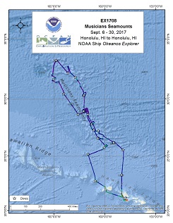
Operations for this cruise will be conducted 24 hours/day and consist of daily remotely operated vehicle (ROV), overnight mapping, and full shore-based participation via telepresence. Operations will include the use of the ship's deep water mapping systems (Kongsberg EM302 multibeam sonar, EK60 split-beam fisheries sonars, Knudsen 3260 chirp sub-bottom profiler sonar, and Teledyne Acoustic Doppler Current Profilers), XBT and CTD casts in support of multibeam sonar mapping operations, OER's two-body ROV Deep Discoverer and Seirios, and the ship's high-bandwidth satellite connection for continuous real-time ship-to-shore communications. Operations are planned in and around Hawaii, the US EEZ, and in the High Seas around the Musicians Seamounts.
Expedition Data and Resources
| Ship Navigation Data (ASCII) | Download | Use zip utility to open file |
| Ship SCS/Sensor Data (ASCII) | Download | Use zip utility to open file |
| Ship SCS/Sensor Data (NetCDF) | Open | NetCDF file format: Special software needed to read |
| Shipboard CTDs | Download | Use zip utility to open file |
| Mapping Products | Download | Use zip utility to open file |
| GIS Products | Download | Use zip utility to open file |
Submersible Data and Resources
| Dive Track KMLs | Download | Use zip utility to open file |
| Event Logs | Open | Click to open link |
| Cruise Video Collection Self-Service Portal | Open | Click to open link |
| Collected Specimens | Open | Click to open link |
| Submersible Navigation/Sensor Data (ASCII) | Download | Use zip utility to open file |
Collected Specimen Repositories
| Smithsonian Institution's National Museum of Natural History Research and Collections (Biological Samples) | Open | Click to visit repository website |
| Ocean Genome Legacy Center (OGL) at Northeastern University | Open | Click to visit repository website |
| Bernice Pauahi Bishop Museum's Marine Invertebrate Collection | Open | Click to visit repository website |
| Oregon State University's Marine Geology Repository | Open | Click to visit repository website |
Educational Resources
| Expedition Education Module | Open | Click to open Education Module |
| Lesson Plans (K-12) | Open | Click to open Lesson Plans |
| Education Materials Collection | Open | Click to open Education Materials |
Links to Archived Data and Resources
| Multibeam Archive Collection | Get Data | Click to Access Archive |
| Water Column Sonar Archive Collection | Get Data | Click to Access Archive |
| Trackline Data (Single-beam and Sub-bottom) | Get Data | Click to Access Archive |
| Physical, Chemical, and Biological Archive Collection | Get Data | Click to Access Archive |
| Collection of Documents | Get Data | Click to Access Archive |
| Expedition Metadata | Open | Click to view Metadata in xml format |
"Tropic of Cancer" Seamount
Area
"Tropic of Cancer" Seamount; Hawaiian Islands
Overview
| Date: | September 07, 2017 |
| Max Depth: | 1855.5 Meters |
| Bottom Time: | 3 Hours 40 Minutes 54 Seconds |
Purpose
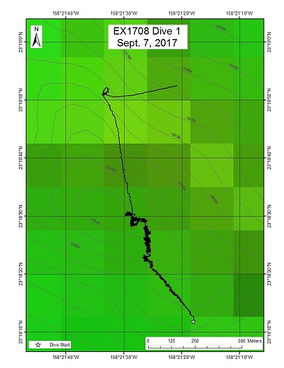
The main purpose of this dive was to validate predictive habitat suitability models for deep sea coral and sponge communities developed by NOAA's National Centers for Coastal Ocean Science. While no previous ROV or HOV dives have ever been conducted at this seamount, "Tropic of Cancer" seamount had high predicted habitat suitability for several deep coral genera, including: Antipatharia, Paragorgiidae, Isididae, Scleraxonia, Calcaxonia, Holaxonia, and Pennatulacea. This dive targeted high slopes and the summit ridge crest where suitability was predicted to be the highest. The first priority was to complete a photographic survey along the full transect. Secondarily, sample collections took place for unusual sightings or rare/novel species, along with rock samples to be used for age dating and geochemical study.
Download & View Files
| Dive Summary Report (PDF - 1.3 MB) | View/Download | Requires Adobe Acrobat Reader to view the Dive Summary Report |
| Dive Track (KML - 62.8 KB) | View/Download | Requires Google Earth or equivalent client to view the Dive Track |
| ROV Ancillary Data (Zip - 1.65 MB) | Download | Link takes you to a public FTP server |
| ROV CTD/Sensor Data (Zip - 5.18 MB) | Download | Link takes you to a public FTP server |
| Camera Platform Sensor Data (Zip - 4.75 MB) | Download | Link takes you to a public FTP server |
| Low-Resolution Video Clips (Zip - 9.14 GB) | Download | Link takes you to a public FTP server |
| Underwater Still Images (Zip - 87.6 MB) | Download | Link takes you to a public FTP server |
| Dive Video Collection Self-Service Portal | Open | Link takes you to an online video discovery and access tool |
"Beach" Ridge
Area
"Beach" Ridge; Musicians Seamounts
Overview
| Date: | September 08, 2017 |
| Max Depth: | 3285.5 Meters |
| Bottom Time: | 3 Hours 24 Minutes 59 Seconds |
Purpose
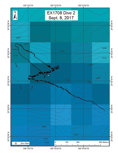
Deep-sea environments around the Musician Seamounts are unexplored. This dive was the first in a series whose purpose is to investigate the similarities and differences in community composition between seamounts and ridges in different parts of the Musicians Seamounts. Sharp elongate ridge features have been shown to harbor largescale, high-density coral communities on the NW Hawaiian Ridge. Therefore, there was a high potential that the elongate ridge-like feature of "Beach" Ridge was host to similar communities. The primary objective for this dive was to characterize the distribution and abundance of benthic fauna and acquire baseline information on deep sea habitats, seafloor geology, and biological communities with particular interest in deep-sea coral and sponge communities. A comparison of the diversity and distribution of coral and sponge communities across the seamounts to the north and to the Hawaiian Ridge and the broader North Pacific is important to understanding the biogeography and connectivity of communities in the Pacific. In addition, the biological and geological sampling at depth will enable a comparison with other areas of the Pacific sampled as part of NOAA's CAPSTONE program.
Download & View Files
| Dive Summary Report (PDF - 1.24 MB) | View/Download | Requires Adobe Acrobat Reader to view the Dive Summary Report |
| Dive Track (KML - 41.5 KB) | View/Download | Requires Google Earth or equivalent client to view the Dive Track |
| ROV Ancillary Data (Zip - 1.58 MB) | Download | Link takes you to a public FTP server |
| ROV CTD/Sensor Data (Zip - 6.31 MB) | Download | Link takes you to a public FTP server |
| Camera Platform Sensor Data (Zip - 5.84 MB) | Download | Link takes you to a public FTP server |
| Low-Resolution Video Clips (Zip - 11.2 GB) | Download | Link takes you to a public FTP server |
| Underwater Still Images (Zip - 89.4 MB) | Download | Link takes you to a public FTP server |
| Dive Video Collection Self-Service Portal | Open | Link takes you to an online video discovery and access tool |
Beethoven Ridge
Area
Beethoven Ridge; Musicians Seamounts
Overview
| Date: | September 09, 2017 |
| Max Depth: | 2534.5 Meters |
| Bottom Time: | 5 Hours 20 Minutes 35 Seconds |
Purpose
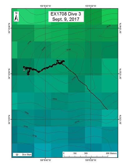
The primary objective for this dive was to characterize the distribution and abundance of benthic fauna. A comparison of the diversity and distribution of coral and sponge communities across the seamounts to the north, the Hawaiian Ridge, and the broader North Pacific is of particular importance to understanding biogeography and connectivity of communities in the Pacific. Sharp elongate ridge features have been shown to harbor large-scale, high-density coral communities on the NW Hawaiian Ridge. As such, the elongate ridges in these areas have a high potential to host similar communities. The priorities were to complete a videographic survey along the transect and collect unique or representative biological and geological samples while covering as much of the feature as possible.
Download & View Files
| Dive Summary Report (PDF - 1.39 MB) | View/Download | Requires Adobe Acrobat Reader to view the Dive Summary Report |
| Dive Track (KML - 69.1 KB) | View/Download | Requires Google Earth or equivalent client to view the Dive Track |
| ROV Ancillary Data (Zip - 1.82 MB) | Download | Link takes you to a public FTP server |
| ROV CTD/Sensor Data (Zip - 6.5 MB) | Download | Link takes you to a public FTP server |
| Camera Platform Sensor Data (Zip - 6 MB) | Download | Link takes you to a public FTP server |
| Low-Resolution Video Clips (Zip - 11.8 GB) | Download | Link takes you to a public FTP server |
| Underwater Still Images (Zip - 157 MB) | Download | Link takes you to a public FTP server |
| Dive Video Collection Self-Service Portal | Open | Link takes you to an online video discovery and access tool |
Sibelius Seamount
Area
Sibelius Seamount; Musicians Seamounts
Overview
| Date: | September 10, 2017 |
| Max Depth: | 2655.1 Meters |
| Bottom Time: | 5 Hours 23 Minutes 59 Seconds |
Purpose
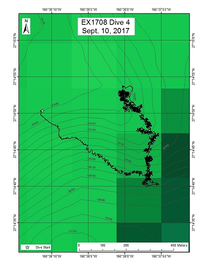
The primary objective for this dive was to characterize the distribution and abundance of benthic fauna along a scarp on the eastern side and upper flank of a large indentation, or cut-out, in the seamount, proposed to be the headwall section of a landslide. A comparison of the diversity and distribution of coral and sponge communities across the seamounts to the north and to the Hawaiian Ridge and the broader North Pacific is of particular importance to understanding biogeography and connectivity of communities in the Pacific. The first priority was to complete a photographic survey along the transect, covering as much of the feature as possible. Secondarily, sample collections occurred for unusual sightings, or rare/novel species. A representative rock sample was also taken for further petrologic, geochemical, and/or dating analyses.
Download & View Files
| Dive Summary Report (PDF - 1.41 MB) | View/Download | Requires Adobe Acrobat Reader to view the Dive Summary Report |
| Dive Track (KML - 82.2 KB) | View/Download | Requires Google Earth or equivalent client to view the Dive Track |
| ROV Ancillary Data (Zip - 1.88 MB) | Download | Link takes you to a public FTP server |
| ROV CTD/Sensor Data (Zip - 8.16 MB) | Download | Link takes you to a public FTP server |
| Camera Platform Sensor Data (Zip - 7.61 MB) | Download | Link takes you to a public FTP server |
| Low-Resolution Video Clips (Zip - 14.7 GB) | Download | Link takes you to a public FTP server |
| Underwater Still Images (Zip - 182 MB) | Download | Link takes you to a public FTP server |
| Dive Video Collection Self-Service Portal | Open | Link takes you to an online video discovery and access tool |
Gounod Seamount
Area
Gounod Seamount; Musicians Seamounts
Overview
| Date: | September 11, 2017 |
| Max Depth: | 2934.3 Meters |
| Bottom Time: | 4 Hours 51 Minutes 53 Seconds |
Purpose
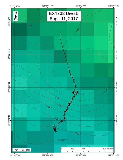
The primary objective for this dive was to characterize the distribution and abundance of benthic fauna at Gounod Seamount. A comparison of the diversity and distribution of coral and sponge communities across the seamounts to the north and to the Hawaiian Ridge and the broader North Pacific is of particular importance to understanding biogeography and connectivity of communities in the Pacific. The first priority was to complete a photographic survey along the transect, covering as much of the feature as possible. Secondarily, sample collections occurred for unusual sightings, or rare/novel species. A representative rock sample was also taken for further petrologic, geochemical, and/or dating analyses. The dive plan was to survey one of a series of small cratered features close to the summit of Gounod Seamount. These volcanic constructs were identified in the multibeam data as a sequence of terraced pancake cones, a landform seen elsewhere in the main and Northwestern Hawaiian Islands. While not especially rare, it is a curious feature because of its eruption style and geomorphological representation. The primary objective for this dive was to characterize the distribution and abundance of benthic fauna and to collect rock samples that can be used to determine the age of the feature and geochemistry of its host rock. A comparison of the diversity and distribution of coral and sponge communities across the seamounts to the north and to the Hawaiian Ridge and the broader North Pacific is of particular importance to understanding the biogeography and connectivity of communities in the Pacific. The dive satisfies the CAPSTONE science themes to "Identify and map vulnerable marine habitats - particularly high-density deep-sea coral and sponge communities," and to "investigate the geologic history of Pacific seamounts".
Download & View Files
| Dive Summary Report (PDF - 1.36 MB) | View/Download | Requires Adobe Acrobat Reader to view the Dive Summary Report |
| Dive Track (KML - 25.9 KB) | View/Download | Requires Google Earth or equivalent client to view the Dive Track |
| ROV Ancillary Data (Zip - 1.74 MB) | Download | Link takes you to a public FTP server |
| ROV CTD/Sensor Data (Zip - 6.42 MB) | Download | Link takes you to a public FTP server |
| Camera Platform Sensor Data (Zip - 6.22 MB) | Download | Link takes you to a public FTP server |
| Low-Resolution Video Clips (Zip - 12.1 GB) | Download | Link takes you to a public FTP server |
| Underwater Still Images (Zip - 111 MB) | Download | Link takes you to a public FTP server |
| Dive Video Collection Self-Service Portal | Open | Link takes you to an online video discovery and access tool |
Debussy Seamount- Aborted Dive
Area
Debussy Seamount- Aborted Dive; Musicians Seamounts
Overview
| Date: | September 13, 2017 |
| Max Depth: | n/a |
| Bottom Time: | n/a |
Purpose
Dive aborted early. See EX1708 Dive 7 for dive on Debussy Seamount.
Download & View Files
| Dive Summary Report (PDF - 638 KB) | View/Download | Requires Adobe Acrobat Reader to view the Dive Summary Report |
| ROV Ancillary Data (Zip - 605 KB) | Download | Link takes you to a public FTP server |
| ROV CTD/Sensor Data (Zip - 477 KB) | Download | Link takes you to a public FTP server |
| Camera Platform Sensor Data (Zip - 480 KB) | Download | Link takes you to a public FTP server |
| Low-Resolution Video Clips (Zip - 1.26 GB) | Download | Link takes you to a public FTP server |
| Underwater Still Images (Zip - 4.7 MB) | Download | Link takes you to a public FTP server |
| Dive Video Collection Self-Service Portal | Open | Link takes you to an online video discovery and access tool |
Debussy Seamount
Area
Debussy Seamount; Musicians Seamounts
Overview
| Date: | September 13, 2017 |
| Max Depth: | 2054.1 Meters |
| Bottom Time: | 3 Hours 7 Minutes 44 Seconds |
Purpose
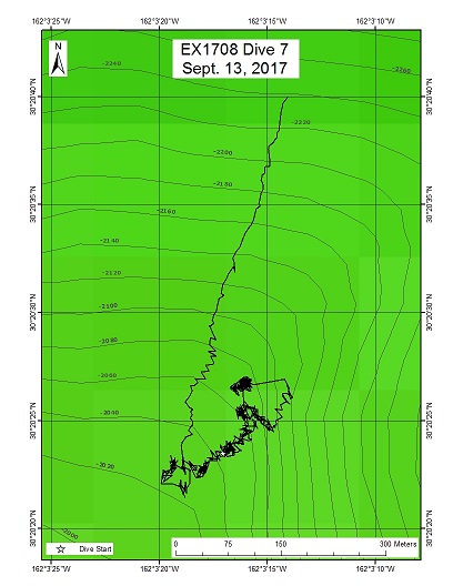
This is the first of two dives that will investigate the similarities and differences in community composition between two relatively isolated seamounts (Mussorgsky and Debussy) that occupy the gap between the two main groups of the Musicians Seamounts. The primary objective for this dive was to characterize the distribution and abundance of benthic fauna, in particular corals, to examine the diversity, biogeography, and connectivity of coral living at Debussy Seamount compared to the isolated Mussorgsky Seamount and to the rest of the sites visited during this expedition. A comparison of the diversity and distribution of coral and sponge communities across the seamounts to the north and to the Hawaiian Ridge and the broader North Pacific will help describe the biogeography and connectivity of communities in the Pacific. The dive satisfies the CAPSTONE science theme to "Identify and map vulnerable marine habitats - particularly high-density deep-sea coral and sponge communities."
Download & View Files
| Dive Summary Report (PDF - 1.37 MB) | View/Download | Requires Adobe Acrobat Reader to view the Dive Summary Report |
| Dive Track (KML - 19.2 KB) | View/Download | Requires Google Earth or equivalent client to view the Dive Track |
| ROV Ancillary Data (Zip - 1.59 MB) | Download | Link takes you to a public FTP server |
| ROV CTD/Sensor Data (Zip - 4.59 MB) | Download | Link takes you to a public FTP server |
| Camera Platform Sensor Data (Zip - 4.28 MB) | Download | Link takes you to a public FTP server |
| Low-Resolution Video Clips (Zip - 8.24 GB) | Download | Link takes you to a public FTP server |
| Underwater Still Images (Zip - 97.7 MB) | Download | Link takes you to a public FTP server |
| Dive Video Collection Self-Service Portal | Open | Link takes you to an online video discovery and access tool |
Wagner Seamount
Area
Wagner Seamount; Musicians Seamounts
Overview
| Date: | September 14, 2017 |
| Max Depth: | 2432.4 Meters |
| Bottom Time: | 5 Hours 26 Minutes 52 Seconds |
Purpose
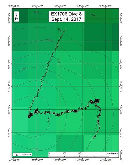
One of the main objectives of this dive was to collect representative rock samples of the feature for geochemical analysis and isotopic dating so as to examine the interaction of hot spot and mid-ocean ridge interactions. The other objective for this dive is to characterize the distribution and abundance of benthic fauna, in particular corals, to examine the diversity, biogeography, and connectivity of corals living the northern seamount group compared to those observed in the southern seamount group and to the rest of the sites visited during this expedition. A comparison of the diversity and distribution of coral and sponge communities across the seamounts to the north and to the Hawaiian Ridge and the broader North Pacific will help describe the biogeography and connectivity of communities in the Pacific. The dive satisfies the CAPSTONE science themes to "investigate the geologic history of Pacific seamounts" and to "identify and map vulnerable marine habitats - particularly high-density deep-sea coral and sponge communities."
Download & View Files
| Dive Summary Report (PDF - 1.37 MB) | View/Download | Requires Adobe Acrobat Reader to view the Dive Summary Report |
| Dive Track (KML - 28.9 KB) | View/Download | Requires Google Earth or equivalent client to view the Dive Track |
| ROV Ancillary Data (Zip - 1.72 MB) | Download | Link takes you to a public FTP server |
| ROV CTD/Sensor Data (Zip - 6.28 MB) | Download | Link takes you to a public FTP server |
| Camera Platform Sensor Data (Zip - 6.04 MB) | Download | Link takes you to a public FTP server |
| Low-Resolution Video Clips (Zip - 11.6 GB) | Download | Link takes you to a public FTP server |
| Underwater Still Images (Zip - 139 MB) | Download | Link takes you to a public FTP server |
| Dive Video Collection Self-Service Portal | Open | Link takes you to an online video discovery and access tool |
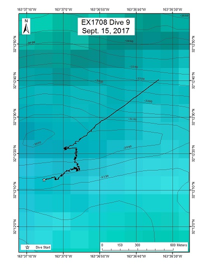
Verdi Seamount
Area
Verdi Seamount; Musicians Seamounts
Overview
| Date: | September 15, 2017 |
| Max Depth: | 3098.3 Meters |
| Bottom Time: | 2 Hours 36 Minutes 40 Seconds |
Purpose
This dive had two main purposes. One was to explore a deep volcanic elongate ridge feature and collect rock samples to provide clues as to the origin of the lineament and the surrounding seamounts, informing a better understanding of the geologic history of the region. Thus, it satisfies the CAPSTONE theme to "investigate the geologic history of Pacific seamounts." The second purpose of the dive was to inform biogeographic patterns of benthic fauna throughout the Musicians Seamounts. A comparison of the diversity and distribution of biological communities (namely,corals and sponges) across the seamounts and to the Hawaiian Ridge and the broader North Pacific will help describe the biogeography and connectivity of communities in the Pacific. This dive satisfies the CAPSTONE science theme to "Identify and map vulnerable marine habitats - particularly high-density deep-sea coral and sponge communities."
Download & View Files
| Dive Summary Report (PDF - 1.18 MB) | View/Download | Requires Adobe Acrobat Reader to view the Dive Summary Report |
| Dive Track (KML - 14.3 KB) | View/Download | Requires Google Earth or equivalent client to view the Dive Track |
| ROV Ancillary Data (Zip - 1.44 MB) | Download | Link takes you to a public FTP server |
| ROV CTD/Sensor Data (Zip - 5.03 MB) | Download | Link takes you to a public FTP server |
| Camera Platform Sensor Data (Zip - 4.68 MB) | Download | Link takes you to a public FTP server |
| Low-Resolution Video Clips (Zip - 8.79 GB) | Download | Link takes you to a public FTP server |
| Underwater Still Images (Zip - 83.9 MB) | Download | Link takes you to a public FTP server |
| Dive Video Collection Self-Service Portal | Open | Link takes you to an online video discovery and access tool |
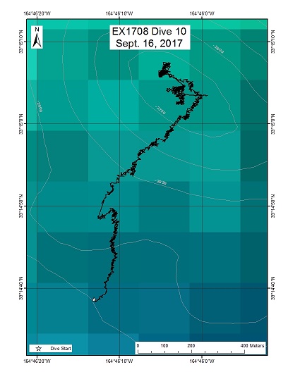
Shostakovich Seamount
Area
Shostakovich Seamount; Musicians Seamounts
Overview
| Date: | September 16, 2017 |
| Max Depth: | 2869.7 Meters |
| Bottom Time: | 4 Hours 44 Minutes 19 Seconds |
Purpose
One purpose of Dive 10 was to explore the summit of a volcanic elongate ridge known as Shostakovich Seamount, providing clues as to the origin of the lineament and surrounding seamounts. Thus, it satisfies the CAPSTONE theme to "investigate the geologic history of Pacific seamounts." Secondly, this dive endeavored to contribute to the knowledge of biogeographic patterns of benthic fauna throughout the Musicians Seamounts. A comparison of the diversity and distribution of biological communities (namely, corals and sponges) across the seamounts and to the Hawaiian Ridge and the broader North Pacific will help describe the biogeography and connectivity of communities in the Pacific. This dive satisfies the CAPSTONE science theme to "Identify and map vulnerable marine habitats - particularly high-density deep-sea coral and sponge communities." The third objective of this dive was to explore and characterize the water column, the largest and least known biome on the planet.
Download & View Files
| Dive Summary Report (PDF - 1.44 MB) | View/Download | Requires Adobe Acrobat Reader to view the Dive Summary Report |
| Dive Track (KML - 72.3 KB) | View/Download | Requires Google Earth or equivalent client to view the Dive Track |
| ROV Ancillary Data (Zip - 1.96 MB) | Download | Link takes you to a public FTP server |
| ROV CTD/Sensor Data (Zip - 7.89 MB) | Download | Link takes you to a public FTP server |
| Camera Platform Sensor Data (Zip - 7.33 MB) | Download | Link takes you to a public FTP server |
| Low-Resolution Video Clips (Zip - 14.1 GB) | Download | Link takes you to a public FTP server |
| Underwater Still Images (Zip - 154 MB) | Download | Link takes you to a public FTP server |
| Dive Video Collection Self-Service Portal | Open | Link takes you to an online video discovery and access tool |
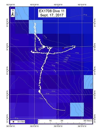
Water Column 1
Area
Water Column 1; Musicians Seamounts
Overview
| Date: | September 17, 2017 |
| Max Depth: | 1003 Meters |
| Bottom Time: | n/a |
Purpose
The water column is one of the most underexplored environments on the planet. Basic information is lacking on the distributions and abundances of midwater organisms in most parts of the globe, and the vicinity of the Musicians Seamounts remains poorly explored. ROV visual surveys provide crucial data on the distributions, abundances, and behaviors of a variety of midwater animals. ROV surveys are especially well-suited to observe the understudied gelatinous fauna, which commonly fall apart using traditional net sampling methods. Collecting acoustic backscatter data (Simrad EK60) throughout the cruise - including during ROV transects - will complement the ROV surveys by providing critical information on the depth and extent of deep scattering layers, diel vertical migrations, and ROV avoidance behavior.
Download & View Files
| Dive Summary Report (PDF - 798 KB) | View/Download | Requires Adobe Acrobat Reader to view the Dive Summary Report |
| Dive Track (KML - 206 KB) | View/Download | Requires Google Earth or equivalent client to view the Dive Track |
| ROV Ancillary Data (Zip - 1.17 MB) | Download | Link takes you to a public FTP server |
| ROV CTD/Sensor Data (Zip - 6.46 MB) | Download | Link takes you to a public FTP server |
| Camera Platform Sensor Data (Zip - 6.3 MB) | Download | Link takes you to a public FTP server |
| Low-Resolution Video Clips (Zip - 11.2 GB) | Download | Link takes you to a public FTP server |
| Underwater Still Images (Zip - 83.8 MB) | Download | Link takes you to a public FTP server |
| Dive Video Collection Self-Service Portal | Open | Link takes you to an online video discovery and access tool |
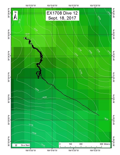
Mussorgsky Seamount
Area
Mussorgsky Seamount; Musicians Seamounts
Overview
| Date: | September 18, 2017 |
| Max Depth: | 2058.6 Meters |
| Bottom Time: | 5 Hours 40 Minutes 12 Seconds |
Purpose
The purpose of this dive was to carry out the second of two dives to investigate the similarities and differences in community composition between two isolated seamounts (Mussorgsky and Debussy) that occupy the gap between the two main groups of the Musicians Seamounts. The primary objective for this dive was to characterize the distribution and abundance of benthic fauna, in particular corals, to examine the diversity, biogeography, and connectivity of corals living here compared to the lesser isolation of Debussy Seamount. Data from this dive will be used to compare benthic fauna distribution to Debussy Seamount and to the rest of the sites visited during this expedition. A comparison of the diversity and distribution of coral and sponge communities across the seamounts to the north and to the Hawaiian Ridge and the broader North Pacific will help describe the biogeography and connectivity of communities in the Pacific. The dive satisfies the CAPSTONE science theme to "Identify and map vulnerable marine habitats - particularly high-density deep-sea coral and sponge communities."
Download & View Files
| Dive Summary Report (PDF - 1.38 MB) | View/Download | Requires Adobe Acrobat Reader to view the Dive Summary Report |
| Dive Track (KML - 90.9 KB) | View/Download | Requires Google Earth or equivalent client to view the Dive Track |
| ROV Ancillary Data (Zip - 1.75 MB) | Download | Link takes you to a public FTP server |
| ROV CTD/Sensor Data (Zip - 5.32 MB) | Download | Link takes you to a public FTP server |
| Camera Platform Sensor Data (Zip - 6.11 MB) | Download | Link takes you to a public FTP server |
| Low-Resolution Video Clips (Zip - 11.6 GB) | Download | Link takes you to a public FTP server |
| Underwater Still Images (Zip - 137 MB) | Download | Link takes you to a public FTP server |
| Dive Video Collection Self-Service Portal | Open | Link takes you to an online video discovery and access tool |
Paganini Seamount
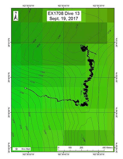
Area
Paganini Seamount; Musicians Seamounts
Overview
| Date: | September 19, 2017 |
| Max Depth: | 1812.2 Meters |
| Bottom Time: | 5 Hours 41 Minutes 16 Seconds |
Purpose
The primary objective for this dive was to characterize the distribution and abundance of benthic fauna. A comparison of the diversity and distribution of coral and sponge communities across the seamounts to the north and to the Hawaiian Ridge and the broader North Pacific is of particular importance to understanding biogeography and connectivity of communities in the Pacific. The dive satisfies the CAPSTONE science theme to "Identify and map vulnerable marine habitats - particularly high-density deep-sea coral and sponge communities."
Download & View Files
| Dive Summary Report (PDF - 1.38 MB) | View/Download | Requires Adobe Acrobat Reader to view the Dive Summary Report |
| Dive Track (KML - 128 KB) | View/Download | Requires Google Earth or equivalent client to view the Dive Track |
| ROV Ancillary Data (Zip - 1.85 MB) | Download | Link takes you to a public FTP server |
| ROV CTD/Sensor Data (Zip - 6.36 MB) | Download | Link takes you to a public FTP server |
| Camera Platform Sensor Data (Zip - 7.31 MB) | Download | Link takes you to a public FTP server |
| Low-Resolution Video Clips (Zip - 13.9 GB) | Download | Link takes you to a public FTP server |
| Underwater Still Images (Zip - 223 MB) | Download | Link takes you to a public FTP server |
| Dive Video Collection Self-Service Portal | Open | Link takes you to an online video discovery and access tool |
Liszt Seamount
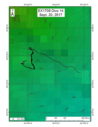
Area
Liszt Seamount; Musicians Seamounts
Overview
| Date: | September 20, 2017 |
| Max Depth: | 2564.5 Meters |
| Bottom Time: | 5 Hours 19 Minutes 47 Seconds |
Purpose
This dive was the first of two dives to investigate the interaction between hot spot volcanism and fracture zones. Lizst Seamount is directly over the closely-spaced fracture zones. Specifically, this dive investigated the geomorphology and targeted rock collections to look for evidence of different magma types or rock composition at areas close to the Murray Fracture Zone. Another goal was to seek evidence of postemplacement deformation of the volcanic edifice due to continuing motion across the fracture zone. This dive also surveyed the biologic communities present on the seafloor to characterize their distribution and abundance.
Download & View Files
| Dive Summary Report (PDF - 1.44 MB) | View/Download | Requires Adobe Acrobat Reader to view the Dive Summary Report |
| Dive Track (KML - 77.1 KB) | View/Download | Requires Google Earth or equivalent client to view the Dive Track |
| ROV Ancillary Data (Zip - 1.86 MB) | Download | Link takes you to a public FTP server |
| ROV CTD/Sensor Data (Zip - 5.94 MB) | Download | Link takes you to a public FTP server |
| Camera Platform Sensor Data (Zip - 6.01 MB) | Download | Link takes you to a public FTP server |
| Low-Resolution Video Clips (Zip - 12.2 GB) | Download | Link takes you to a public FTP server |
| Underwater Still Images (Zip - 127 MB) | Download | Link takes you to a public FTP server |
| Dive Video Collection Self-Service Portal | Open | Link takes you to an online video discovery and access tool |
Mozart Seamount
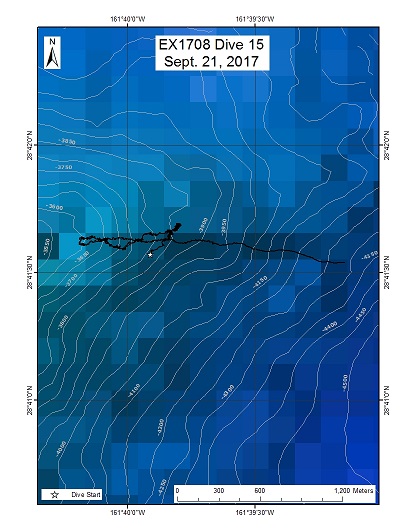
Area
Mozart Seamount; Musicians Seamounts
Overview
| Date: | September 21, 2017 |
| Max Depth: | 3854.1 Meters |
| Bottom Time: | 5 Hours 58 Minutes 13 Seconds |
Purpose
This dive was the second of two dives to investigate the interaction between hotspot volcanism and fracture zones. Mozart Seamount is near the Murray Fracture zone, but not directly intersecting it. Specifically, the purpose of this dive was to investigate the geomorphology and to target rock collections to look for evidence of different magma types or rock composition at areas close to the Murray Fracture Zone, along with any differences between Mozart Seamount and observations made at Liszt Seamount (Dive 14). Another goal was to seek evidence of post-emplacement deformation of the volcanic edifice due to continuing motion across the fracture zone. This dive also surveyed the biologic communities present on the seafloor to characterize their distribution and abundance.
Download & View Files
| Dive Summary Report (PDF - 1.54 MB) | View/Download | Requires Adobe Acrobat Reader to view the Dive Summary Report |
| Dive Track (KML - 42.5 KB) | View/Download | Requires Google Earth or equivalent client to view the Dive Track |
| ROV Ancillary Data (Zip - 1.97 MB) | Download | Link takes you to a public FTP server |
| ROV CTD/Sensor Data (Zip - 7.37 MB) | Download | Link takes you to a public FTP server |
| Camera Platform Sensor Data (Zip - 7.42 MB) | Download | Link takes you to a public FTP server |
| Low-Resolution Video Clips (Zip - 14.6 GB) | Download | Link takes you to a public FTP server |
| Underwater Still Images (Zip - 210 MB) | Download | Link takes you to a public FTP server |
| Dive Video Collection Self-Service Portal | Open | Link takes you to an online video discovery and access tool |
Water Column 2
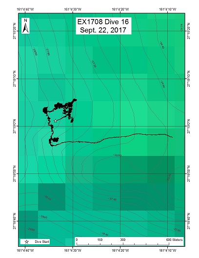
Area
Water Column 2; Musicians Seamounts
Overview
| Date: | September 22, 2017 |
| Max Depth: | 1001.3 Meters |
| Bottom Time: | n/a |
Purpose
The water column is one of the most underexplored environments on the planet. Basic information is lacking on the distributions and abundances of midwater organisms in most parts of the globe, and the vicinity of the Musicians Seamounts remains poorly explored. ROV visual surveys provide crucial data on the distributions, abundances, and behaviors of a variety of midwater animals. ROV surveys are especially well-suited to observe the understudied gelatinous fauna, which commonly fall apart using traditional net sampling methods. Collecting acoustic backscatter data (Simrad EK60) throughout the cruise - including during ROV transects - will complement the ROV surveys by providing critical information on the depth and extent of deep scattering layers, diel vertical migrations, and ROV avoidance behavior.
Download & View Files
| Dive Summary Report (PDF - 813 KB) | View/Download | Requires Adobe Acrobat Reader to view the Dive Summary Report |
| Dive Track (KML - 185 KB) | View/Download | Requires Google Earth or equivalent client to view the Dive Track |
| ROV Ancillary Data (Zip - 1.2 MB) | Download | Link takes you to a public FTP server |
| ROV CTD/Sensor Data (Zip - 5.99 MB) | Download | Link takes you to a public FTP server |
| Camera Platform Sensor Data (Zip - 6.27 MB) | Download | Link takes you to a public FTP server |
| Low-Resolution Video Clips (Zip - 11.2 GB) | Download | Link takes you to a public FTP server |
| Underwater Still Images (Zip - 102 MB) | Download | Link takes you to a public FTP server |
| Dive Video Collection Self-Service Portal | Open | Link takes you to an online video discovery and access tool |
Rapano Ridge
Area
Rapano Ridge; Musicians Seamounts
Overview
| Date: | September 23, 2017 |
| Max Depth: | 2050.3 Meters |
| Bottom Time: | 5 Hours 45 Minutes 11 Seconds |
Purpose
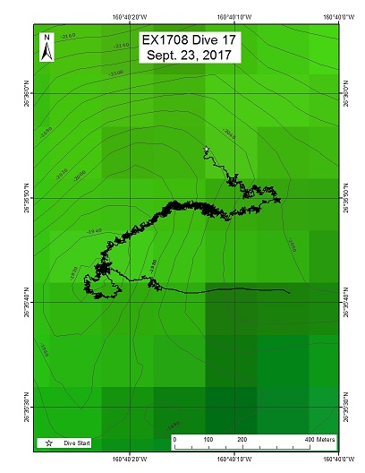
The primary objective for this dive is to characterize the distribution and abundance of benthic fauna. The dive is part of a series that will investigate the similarities and differences in community composition between seamounts and ridges in different parts of the Musicians Seamounts. A comparison of the diversity and distribution of coral and sponge communities across the seamounts to the north and to the Hawaiian Ridge and the broader North Pacific is of particular importance to understanding biogeography and connectivity of communities in the Pacific.
Download & View Files
| Dive Summary Report (PDF - 1.32 MB) | View/Download | Requires Adobe Acrobat Reader to view the Dive Summary Report |
| Dive Track (KML - 122 KB) | View/Download | Requires Google Earth or equivalent client to view the Dive Track |
| ROV Ancillary Data (Zip - 1.83 MB) | Download | Link takes you to a public FTP server |
| ROV CTD/Sensor Data (Zip - 7.29 MB) | Download | Link takes you to a public FTP server |
| Camera Platform Sensor Data (Zip - 7.4 MB) | Download | Link takes you to a public FTP server |
| Low-Resolution Video Clips (Zip - 14.2 GB) | Download | Link takes you to a public FTP server |
| Underwater Still Images (Zip - 231 MB) | Download | Link takes you to a public FTP server |
| Dive Video Collection Self-Service Portal | Open | Link takes you to an online video discovery and access tool |
Schumann Seamount
Area
Schumann Seamount; Musicians Seamounts
Overview
| Date: | September 24, 2017 |
| Max Depth: | 2317.4 Meters |
| Bottom Time: | 5 Hours 34 Minutes 10 Seconds |
Purpose
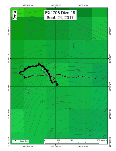
The primary objective for this dive was to characterize the distribution and abundance of benthic fauna. A comparison of the diversity and distribution of coral and sponge communities across the seamounts to the north and to the Hawaiian Ridge and the broader North Pacific is of particular importance to understanding biogeography and connectivity of communities in the Pacific. Sharp elongate ridge features have been shown to harbor large-scale, high-density coral communities on the NW Hawaiian Ridge. As such, the elongate ridges in these areas have a high potential to host similar communities. The dive satisfies the CAPSTONE science theme to "Identify and map vulnerable marine habitats - particularly high-density deep-sea coral and sponge communities."
Download & View Files
| Dive Summary Report (PDF - 1.45 MB) | View/Download | Requires Adobe Acrobat Reader to view the Dive Summary Report |
| Dive Track (KML - 90.5 KB) | View/Download | Requires Google Earth or equivalent client to view the Dive Track |
| ROV Ancillary Data (Zip - 1.87 MB) | Download | Link takes you to a public FTP server |
| ROV CTD/Sensor Data (Zip - 5.93 MB) | Download | Link takes you to a public FTP server |
| Camera Platform Sensor Data (Zip - 5.92 MB) | Download | Link takes you to a public FTP server |
| Low-Resolution Video Clips (Zip - 11.6 GB) | Download | Link takes you to a public FTP server |
| Underwater Still Images (Zip - 123 MB) | Download | Link takes you to a public FTP server |
| Dive Video Collection Self-Service Portal | Open | Link takes you to an online video discovery and access tool |
Mendelsohn Seamount
Area
Mendelsohn Seamount; US EEZ around Hawaii, South of Musicians / North of Hawaiian Islands
Overview
| Date: | September 25, 2017 |
| Max Depth: | 1795.8 Meters |
| Bottom Time: | 4 Hours 29 Minutes 39 Seconds |
Purpose
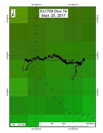
Mendelsohn Seamount is a bit of an enigma. Is it part of the Musicians Seamounts or a separate second parallel chain of seamounts to the Hawaiian chain? The offset bunch of seamounts located between the Hawaiian Ridge and the Liliokalani Ridge are enigmatic. The fork at the end of the Liliokalani seamount chain is also enigmatic (i.e., How does a hot spot create a fork?). One potential explanation is they are an endpoint for a hot spot plume that originated in the Liliokalani hot spot trace but much later, thus explaining the forked nature of the latter. Additional rock samples could be very useful in determining if this hypothesis is correct. This could also help inform general plate tectonic questions that linger with the Hawaiian hot spot chain regarding where the plate actually changed direction, or rather, did the Hawaiian plume drifted to form the bend? In other words, if a second trace recorded a similar bend, then the plate must have changed direction. Biologically, this seamount also sits at a pivotal point. It could serve as a biological stepping stone for benthic communities. Data from this dive will help establish the connection between the NWHI and the Musicians Seamounts. A comparison of the diversity and distribution of coral and sponge communities across the Musicians Seamounts to the north and to the Hawaiian Ridge and the broader North Pacific is of particular importance to understanding the biogeography and connectivity of communities in the Pacific.
Download & View Files
| Dive Summary Report (PDF - 1.22 MB) | View/Download | Requires Adobe Acrobat Reader to view the Dive Summary Report |
| Dive Track (KML - 98.4 KB) | View/Download | Requires Google Earth or equivalent client to view the Dive Track |
| ROV Ancillary Data (Zip - 1.58 MB) | Download | Link takes you to a public FTP server |
| ROV CTD/Sensor Data (Zip - 4.82 MB) | Download | Link takes you to a public FTP server |
| Camera Platform Sensor Data (Zip - 5 MB) | Download | Link takes you to a public FTP server |
| Low-Resolution Video Clips (Zip - 9.51 GB) | Download | Link takes you to a public FTP server |
| Underwater Still Images (Zip - 129 MB) | Download | Link takes you to a public FTP server |
| Dive Video Collection Self-Service Portal | Open | Link takes you to an online video discovery and access tool |
Middle Bank
Area
Middle Bank; Just outside of PMNM, US EEZ Hawaii
Overview
| Date: | September 26, 2017 |
| Max Depth: | 477.7 Meters |
| Bottom Time: | 7 Hours 3 Minutes 10 Seconds |
Purpose
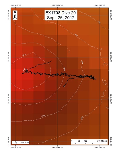
This dive, located just outside the boundary of PMNM, was carried out at the request of the Monument staff and NOAA NOS NCCOS. The objectives were 1) to explore fish and invertebrate boundary communities and 2) ground truth coral habitat suitability and taxonomic richness models based on multibeam sonar bathymetry and slope data. Management unit species within the precious coral and bottomfish fisheries were of particular interest. The selection of this dive site on Middle Bank was based on high-resolution multibeam bathymetry, slope, and backscatter data revealing the presence of a pinnacle feature that likely had populations of bottomfish and precious corals. In addition, regional coral habitat suitability models indicated it was close to an area that had high potential habitat suitability for the occurrence of seven or more genera of coral species. Draft models were produced as a collaborative effort by NOAA NOS NCCOS as part of a BOEM-funded Biogeographic Assessment of the Main Hawaiian Islands. More information about the project can be found at: http://coastalscience.noaa.gov/projects/detail?key=163.
Download & View Files
| Dive Summary Report (PDF - 1.41 MB) | View/Download | Requires Adobe Acrobat Reader to view the Dive Summary Report |
| Dive Track (KML - 241 KB) | View/Download | Requires Google Earth or equivalent client to view the Dive Track |
| ROV Ancillary Data (Zip - 1.79 MB) | Download | Link takes you to a public FTP server |
| ROV CTD/Sensor Data (Zip - 6.21 MB) | Download | Link takes you to a public FTP server |
| Camera Platform Sensor Data (Zip - 6.24 MB) | Download | Link takes you to a public FTP server |
| Low-Resolution Video Clips (Zip - 11.6 GB) | Download | Link takes you to a public FTP server |
| Underwater Still Images (Zip - 170 MB) | Download | Link takes you to a public FTP server |
| Dive Video Collection Self-Service Portal | Open | Link takes you to an online video discovery and access tool |
Caiman Targets
Area
Caiman Targets; Oahu
Overview
| Date: | September 28, 2017 |
| Max Depth: | n/a |
| Bottom Time: | n/a |
Purpose
To investigate a series of sonar anomalies in an effort to locate the remains of the Japanese fast submarine I-203 (Sentaka-type) captured at the end of WWII, brought to Pearl Harbor as part of the 5-submarine prize fleet, and disposed near this area in 1946. If found, conduct non-invasive survey focusing on the innovative features of this rare fast attack vessel.
Download & View Files
| Dive Summary Report (PDF - 707 KB) | View/Download | Requires Adobe Acrobat Reader to view the Dive Summary Report |
| Dive Track (KML - 81.5 KB) | View/Download | Requires Google Earth or equivalent client to view the Dive Track |
| ROV Ancillary Data (Zip - 1.06 MB) | Download | Link takes you to a public FTP server |
| ROV CTD/Sensor Data (Zip - 6.13 MB) | Download | Link takes you to a public FTP server |
| Camera Platform Sensor Data (Zip - 6.11 MB) | Download | Link takes you to a public FTP server |
| Low-Resolution Video Clips (Zip - 11.1 GB) | Download | Link takes you to a public FTP server |
| Underwater Still Images (Zip - 81.9 MB) | Download | Link takes you to a public FTP server |
| Dive Video Collection Self-Service Portal | Open | Link takes you to an online video discovery and access tool |
USS Baltimore
Area
USS Baltimore; Oahu
Overview
| Date: | September 29, 2017 |
| Max Depth: | n/a |
| Bottom Time: | n/a |
Purpose
Maritime heritage dive to conduct non-invasive video survey of remains of USS Baltimore, late 19th-century USN protected cruiser scuttled near Oahu in 1944, including: documentation of specific 19th-century features; photogrammetry and mosaic data compilation; assessment of scuttling damage; assessment of preservation/deterioration status; marine species inventory.
Download & View Files
| Dive Summary Report (PDF - 705 KB) | View/Download | Requires Adobe Acrobat Reader to view the Dive Summary Report |
| Dive Track (KML - 240 KB) | View/Download | Requires Google Earth or equivalent client to view the Dive Track |
| ROV Ancillary Data (Zip - 1.14 MB) | Download | Link takes you to a public FTP server |
| ROV CTD/Sensor Data (Zip - 6.21 MB) | Download | Link takes you to a public FTP server |
| Camera Platform Sensor Data (Zip - 6.42 MB) | Download | Link takes you to a public FTP server |
| Low-Resolution Video Clips (Zip - 11.5 GB) | Download | Link takes you to a public FTP server |
| Underwater Still Images (Zip - 175 MB) | Download | Link takes you to a public FTP server |
| Dive Video Collection Self-Service Portal | Open | Link takes you to an online video discovery and access tool |

