
New England and Canada ROV and Mapping
Vessel: NOAA Ship Okeanos Explorer; Expedition Dates: August 26, 2019 to September 15, 2019
Ports: Halifax, Nova Scotia to North Kingstown, RI
Project Principals: Daniel Wagner, NOAA/OAR/OER (Expedition Coordinator); Michael White, NOAA/OAR/OER (Mapping Lead)
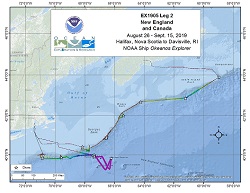
Using OER's dual-body ROV, the expedition completed 12 successful dives ranging in depth from 306 to 2,668 meters that explored a wide diversity of habitats and geological features, including deep-sea coral and sponge communities, deep-sea fish habitats, midwater habitats, submarine canyons, seamounts, and more. Midwater explorations at depths ranging from 700 to 2,175 meters were conducted during one ROV dive in order to investigate the diversity and abundance of the largely unknown pelagic fauna of the region. Overall, hundreds of different species were observed during ROV dive operations, including several potentially undescribed species and several range extensions. Throughout the expedition, 124 biological samples were collected (35 primary and 89 associated taxa), 26 of which likely represent either range expansions or potential new species. The remainder of the biological samples were collected to support studies on connectivity and biogeographic patterns across the Atlantic Ocean. Six high-density communities of deep-sea corals and sponges were documented during the expedition, including a high-density forest of bamboo corals at depths of 1,100 meters inside Gully Canyon, and a highly diverse and dense assemblage of deep-sea sponges and corals at depths of 2,500-2,650 meters on Retriever Seamount, which is among the deepest known such communities in the region. Additional patches of high-density communities of deep-sea corals and sponges were documented during dives on an unnamed canyon, Kinlan Canyon, Bear Seamount, and Veatch Canyon. Other noteworthy ROV observations included records of three large (> 1 meter) individuals of the endangered Atlantic Halibut, Hippoglossus hippoglossus.Additionally, ROV dives documented various unique geological features, including inactive fluid expulsion features inside Verrill Canyon, evidence of recent sediment transport within Oceanographer Canyon, and a continuous sequence of carbonate rock (>100 meters thick) with near vertical relief at Veatch Canyon. Five geological samples were collected to support laboratory analyses that will increase our understanding of the geological context of this region.
Expedition Data and Resources
| Expedition Summary Report (PDF - 7.26 MB) | Open | Click to open link |
| Mapping Summary Report (PDF - 2.15 MB) | Open | Click to open link |
| Ship Navigation Data (ASCII) | Download | Use zip utility to open file |
| Ship SCS/Sensor Data (ASCII) | Download | Use zip utility to open file |
| Ship SCS/Sensor Data (NetCDF) | Open | NetCDF file format: Special software needed to read |
| Shipboard CTDs | Download | Use zip utility to open file |
| Mapping Products | Download | Use zip utility to open file |
| GIS Products | Download | Use zip utility to open file |
Submersible Data and Resources
| Dive Summaries | Download | Use zip utility to open file |
| Dive Tracks | Download | Use zip utility to open file |
| ROV Dive Event Logs | Open | Click to open link |
| Cruise Video Collection Self-Service Portal | Open | Click to open link |
| Specimens Collected During Dive Operations | Download | Click to open link |
| Submersible Navigation/Sensor Data (ASCII) | Download | Use zip utility to open file |
Collected Specimen Repositories
| Smithsonian National Museum of Natural History (Biological Samples) | Open | Click to visit repository website |
| Oregon State University's Marine Geology Repository | Open | Click to visit repository website |
Educational Resources
| Expedition Education Module | Open | Click to open Education Module |
| Lesson Plans (K-12) | Open | Click to open Lesson Plans |
| Education Materials Collection | Open | Click to open Education Materials |
Publication Resources
| NOAA Central Library OER Bibliography | Open | Click to open OER Bibliography |
Links to Archived Data and Resources
| Multibeam Archive Collection | Get Data | Click to Access Archive |
| Water Column Sonar Archive Collection | Get Data | Click to Access Archive |
| Single-beam and Sub-bottom Data Archive Collection | Get Data | Click to Access Archive |
| Physical, Chemical, and Biological Archive Collection | Get Data | Click to Access Archive |
| Expedition Metadata | Open | Click to view Metadata in xml format |
Gully Canyon
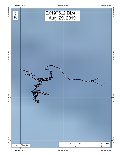
Area
Gully Canyon; U.S. and Canadian Atlantic Continental Margin
Overview
| Date: | August 29, 2019 |
| Max Depth: | 1348 Meters |
| Bottom Time: | 3 Hours 58 Minutes 56 Seconds |
Purpose
This dive was located within the Gully Marine Protected Area (MPA), which protects the largest submarine canyon in the Western North Atlantic. This productive environment is host to a number of protected fish and marine mammal species, and assessment of biodiversity is critical for effective MPA management. The dive was meant to explore the eastern wall of the Gully Canyon, which has never been surveyed with deep-sea submersibles. Additionally, this dive sought to document and collect several species of sponges and corals which are thought to be new to science. Furthermore, this dive sought to explore the recent geological activity of the canyon in the form of seabed ripples, fresh debris fields, and axial canyon incision.
Download & View Files
| Dive Summary Report (PDF - 1.98 MB) | View/Download | Requires Adobe Acrobat Reader to view the Dive Summary Report |
| Dive Track (KML - 68.2 KB) | View/Download | Requires Google Earth or equivalent client to view the Dive Track |
| ROV Ancillary Data (Zip - 4.28 MB) | Download | Link takes you to a public FTP server |
| Camera Platform Sensor Data (Zip - 4.93 MB) | Download | Link takes you to a public FTP server |
| Low-Resolution Video Clips (Zip - 10.2 GB) | Download | Link takes you to a public FTP server |
| Underwater Still Images (Zip - 112 MB) | Download | Link takes you to a public FTP server |
| Dive Video Collection Self-Service Portal | Open | Link takes you to an online video discovery and access tool |
Verrill Steps
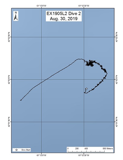
Area
Verrill Steps; U.S. and Canadian Atlantic Continental Margin
Overview
| Date: | August 30, 2019 |
| Max Depth: | 2506 Meters |
| Bottom Time: | 3 Hours 13 Minutes 22 Seconds |
Purpose
The purpose of this dive was to explore deeper depths (~2500 m) inside Verrill Canyon, which have not previously been surveyed. Specifically, this dive sought to explore step-like features of Verrill Canyon, thought to have been formed by turbidity currents; the steep relief between steps was expected to prpvode suitable habitat for deep-sea corals and sponges. The dive further sought to explore the geological setting of the steps, as well as survey and sample biological communities along them.
Download & View Files
| Dive Summary Report (PDF - 3.37 MB) | View/Download | Requires Adobe Acrobat Reader to view the Dive Summary Report |
| Dive Track (KML - 67.4 KB) | View/Download | Requires Google Earth or equivalent client to view the Dive Track |
| ROV Ancillary Data (Zip - 5.79 MB) | Download | Link takes you to a public FTP server |
| Camera Platform Sensor Data (Zip - 4.81 MB) | Download | Link takes you to a public FTP server |
| Low-Resolution Video Clips (Zip - 10.5 GB) | Download | Link takes you to a public FTP server |
| Underwater Still Images (Zip - 83.3 MB) | Download | Link takes you to a public FTP server |
| Dive Video Collection Self-Service Portal | Open | Link takes you to an online video discovery and access tool |
Vazella Sponge Grounds
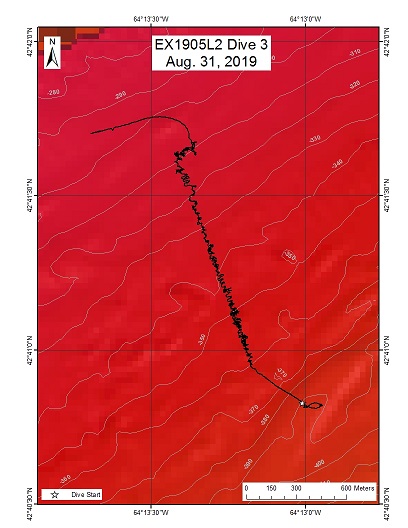
Area
Vazella Sponge Grounds; U.S. and Canadian Atlantic Continental Margin
Overview
| Date: | August 31, 2019 |
| Max Depth: | 360 Meters |
| Bottom Time: | 5 Hours 54 Minutes 5 Seconds |
Purpose
This location on the Scotian Shelf was predicted to have high habitat suitability for Vazella sponges by models. This dive sought to test those habitat suitability models and add data (presence or absence) for future model iterations.
Download & View Files
| Dive Summary Report (PDF - 1.72 MB) | View/Download | Requires Adobe Acrobat Reader to view the Dive Summary Report |
| Dive Track (KML - 66.7 KB) | View/Download | Requires Google Earth or equivalent client to view the Dive Track |
| ROV Ancillary Data (Zip - 4.47 MB) | Download | Link takes you to a public FTP server |
| Camera Platform Sensor Data (Zip - 6.02 MB) | Download | Link takes you to a public FTP server |
| Low-Resolution Video Clips (Zip - 12.1 GB) | Download | Link takes you to a public FTP server |
| Underwater Still Images (Zip - 130 MB) | Download | Link takes you to a public FTP server |
| Dive Video Collection Self-Service Portal | Open | Link takes you to an online video discovery and access tool |
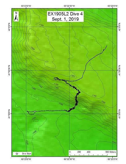
Northeast Channel
Area
Northeast Channel; U.S. and Canadian Atlantic Continental Margin
Overview
| Date: | September 01, 2019 |
| Max Depth: | 1496 Meters |
| Bottom Time: | 5 Hours 51 Minutes 54 Seconds |
Purpose
The Northeast Channel dive site was located immediately proximal to the Northeast Channel Coral Conservation Area, designed to protect deepwater coral and sponge communities from bottom contact fishing. The purpose of the dive was to characterize the deep-sea benthic community inside this current area of interest, which is under consideration for expansion of the protected area. Furthermore, the dive sought to investigate the geological origins of this site, presumed to be composed of glacial trough mouth fan materials.
Download & View Files
| Dive Summary Report (PDF - 2.33 MB) | View/Download | Requires Adobe Acrobat Reader to view the Dive Summary Report |
| Dive Track (KML - 67.7 KB) | View/Download | Requires Google Earth or equivalent client to view the Dive Track |
| ROV Ancillary Data (Zip - 5.36 MB) | Download | Link takes you to a public FTP server |
| Camera Platform Sensor Data (Zip - 6.09 MB) | Download | Link takes you to a public FTP server |
| Low-Resolution Video Clips (Zip - 13.5 GB) | Download | Link takes you to a public FTP server |
| Underwater Still Images (Zip - 135 MB) | Download | Link takes you to a public FTP server |
| Dive Video Collection Self-Service Portal | Open | Link takes you to an online video discovery and access tool |
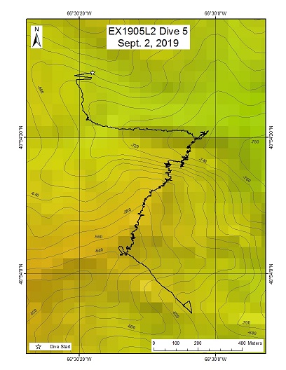
Unnamed Canyon
Area
Unnamed Canyon; U.S. and Canadian Atlantic Continental Margin
Overview
| Date: | September 02, 2019 |
| Max Depth: | 758 Meters |
| Bottom Time: | 6 Hours 35 Minutes 17 Seconds |
Purpose
This unnamed canyon, as well as many nearby shelf-sourced minor canyons in this region have mostly been unexplored. Kinlan Canyon, located south of this unnamed canyon, is known to be suitable habitat for Lophelia pertusa coral communities. The planned dive track was designed to cross the canyon axis and thereby sought to assess the geologically recent sediment transport history of the canyon, as well as investigate the benthic communities of the area.
Download & View Files
| Dive Summary Report (PDF - 2.18 MB) | View/Download | Requires Adobe Acrobat Reader to view the Dive Summary Report |
| Dive Track (KML - 66.6 KB) | View/Download | Requires Google Earth or equivalent client to view the Dive Track |
| ROV Ancillary Data (Zip - 5.10 MB) | Download | Link takes you to a public FTP server |
| Camera Platform Sensor Data (Zip - 6.68 MB) | Download | Link takes you to a public FTP server |
| Low-Resolution Video Clips (Zip - 13.1 GB) | Download | Link takes you to a public FTP server |
| Underwater Still Images (Zip - 151 MB) | Download | Link takes you to a public FTP server |
| Dive Video Collection Self-Service Portal | Open | Link takes you to an online video discovery and access tool |
Kinlan Canyon

Area
Kinlan Canyon; U.S. and Canadian Atlantic Continental Margin
Overview
| Date: | September 03, 2019 |
| Max Depth: | 1076 Meters |
| Bottom Time: | 4 Hours 27 Minutes 8 Seconds |
Purpose
Two previous dives have been conducted in Kinlan Canyon, including a ROV Deep Discoverer dive in 2013 and a ROV ROPOS dive in 2017. Both of those dives documented communities of the reef-building coral Lophelia pertusa. The purpose of this dive was to assess the intra-canyon extent of Lophelia pertusa and other coral and sponge communities. This was also a tribute dive dedicated to the memory of Dr. Brian Kinlan, a former NOAA scientist who pioneered the use of predictive habitat suitability modeling for scientific exploration and conservation, after who this canyon was named.
Download & View Files
| Dive Summary Report (PDF - 3.11 MB) | View/Download | Requires Adobe Acrobat Reader to view the Dive Summary Report |
| Dive Track (KML - 66.6 KB) | View/Download | Requires Google Earth or equivalent client to view the Dive Track |
| ROV Ancillary Data (Zip - 5.41 MB) | Download | Link takes you to a public FTP server |
| Camera Platform Sensor Data (Zip - 4.87 MB) | Download | Link takes you to a public FTP server |
| Low-Resolution Video Clips (Zip - 10.5 GB) | Download | Link takes you to a public FTP server |
| Underwater Still Images (Zip - 122 MB) | Download | Link takes you to a public FTP server |
| Dive Video Collection Self-Service Portal | Open | Link takes you to an online video discovery and access tool |
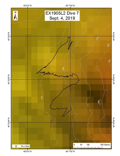
Oceanographer Canyon
Area
Oceanographer Canyon; U.S. and Canadian Atlantic Continental Margin
Overview
| Date: | September 04, 2019 |
| Max Depth: | 600 Meters |
| Bottom Time: | 1 Hours 54 Minutes 6 Seconds |
Purpose
This site was located within the canyons unit of the Northeast Canyons and Seamounts Marine National Monument. Previous dives within Oceanographer Canyon documented dense deep-sea coral communities, and the dive location was predicted to be highly suitable for coral habitat. This dive also sought to expand knowledge on coral distribution within the canyon.
Download & View Files
| Dive Summary Report (PDF - 1.51 MB) | View/Download | Requires Adobe Acrobat Reader to view the Dive Summary Report |
| Dive Track (KML - 64.6 KB) | View/Download | Requires Google Earth or equivalent client to view the Dive Track |
| ROV Ancillary Data (Zip - 2.75 MB) | Download | Link takes you to a public FTP server |
| Camera Platform Sensor Data (Zip - 3.10 MB) | Download | Link takes you to a public FTP server |
| Low-Resolution Video Clips (Zip - 5.88 GB) | Download | Link takes you to a public FTP server |
| Underwater Still Images (Zip - 70 MB) | Download | Link takes you to a public FTP server |
| Dive Video Collection Self-Service Portal | Open | Link takes you to an online video discovery and access tool |
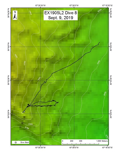
Bear Seamount eastern slope
Area
Bear Seamount eastern slope; U.S. and Canadian Atlantic Continental Margin
Overview
| Date: | September 09, 2019 |
| Max Depth: | 2139 Meters |
| Bottom Time: | 5 Hours 18 Minutes 19 Seconds |
Purpose
The purpose of this dive was to explore a previously unsurveyed area on the southeast corner of Bear Seamount for deep-sea corals and sponges. Additionally, this dive sought to Investigate whether there is surficial evidence for apparent normal faulting cutting across the width of Bear Seamount.
Download & View Files
| Dive Summary Report (PDF - 1.45 MB) | View/Download | Requires Adobe Acrobat Reader to view the Dive Summary Report |
| Dive Track (KML - 68.1 KB) | View/Download | Requires Google Earth or equivalent client to view the Dive Track |
| ROV Ancillary Data (Zip - 4.87 MB) | Download | Link takes you to a public FTP server |
| Camera Platform Sensor Data (Zip - 6.97 MB) | Download | Link takes you to a public FTP server |
| Low-Resolution Video Clips (Zip - 14.9 GB) | Download | Link takes you to a public FTP server |
| Underwater Still Images (Zip - 121 MB) | Download | Link takes you to a public FTP server |
| Dive Video Collection Self-Service Portal | Open | Link takes you to an online video discovery and access tool |
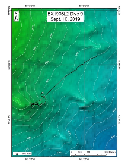
Retriever Seamount
Area
Retriever Seamount; U.S. and Canadian Atlantic Continental Margin
Overview
| Date: | September 10, 2019 |
| Max Depth: | 2671 Meters |
| Bottom Time: | 4 Hours 38 Minutes 16 Seconds |
Purpose
Previous dives on Retriever Seamount targeted depths >3,800 m and <2,400 m. This dive sought to explore the depth range between those two previous dives in order to add valuable new information on the diversity of habitats across various depth ranges of Retriever Seamount. Additionally, this dive explored the southeast corner of Retriever Seamount, an area of the seamount which has also not been explored. The site was expected to be highly suitable habitat for deep-sea corals and sponges as a result of the steepness of its slopes slopes identified via seafloor mapping.
Download & View Files
| Dive Summary Report (PDF - 2.28 MB) | View/Download | Requires Adobe Acrobat Reader to view the Dive Summary Report |
| Dive Track (KML - 68.3 KB) | View/Download | Requires Google Earth or equivalent client to view the Dive Track |
| ROV Ancillary Data (Zip - 5.39 MB) | Download | Link takes you to a public FTP server |
| Camera Platform Sensor Data (Zip - 6.69 MB) | Download | Link takes you to a public FTP server |
| Low-Resolution Video Clips (Zip - 13.5 GB) | Download | Link takes you to a public FTP server |
| Underwater Still Images (Zip - 137 MB) | Download | Link takes you to a public FTP server |
| Dive Video Collection Self-Service Portal | Open | Link takes you to an online video discovery and access tool |
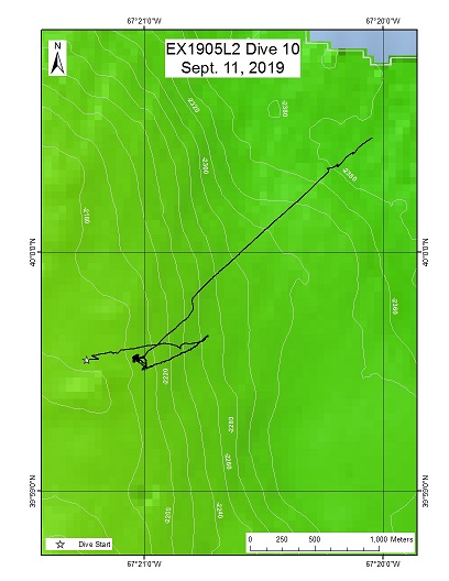
Bear Seamount Midwater
Area
Bear Seamount Midwater; U.S. and Canadian Atlantic Continental Margin
Overview
| Date: | September 11, 2019 |
| Max Depth: | 2181 Meters |
| Bottom Time: | 0 Hours 51 Minutes 49 Seconds |
Purpose
This dive site was located just north of Bear Seamount, within the Northeast Canyons and Seamounts Marine National Monument. There have been extensive nekton trawling surveys in the vicinity of this site, as well as several ROV dives that explored benthic habitats on Bear Seamount. However, to date there have been no midwater ROV dives on the seamount. This dive therefore sought to collect valuable midwater video data that can be compared to historic midwater trawl data.
Download & View Files
| Dive Summary Report (PDF - 1.14 MB) | View/Download | Requires Adobe Acrobat Reader to view the Dive Summary Report |
| Dive Track (KML - 67.7 KB) | View/Download | Requires Google Earth or equivalent client to view the Dive Track |
| ROV Ancillary Data (Zip - 3.69 MB) | Download | Link takes you to a public FTP server |
| Camera Platform Sensor Data (Zip - 5.77 MB) | Download | Link takes you to a public FTP server |
| Low-Resolution Video Clips (Zip - 11.1 GB) | Download | Link takes you to a public FTP server |
| Underwater Still Images (Zip - 77.5 MB) | Download | Link takes you to a public FTP server |
| Dive Video Collection Self-Service Portal | Open | Link takes you to an online video discovery and access tool |
Veatch Canyon

Area
Veatch Canyon; U.S. and Canadian Atlantic Continental Margin
Overview
| Date: | September 12, 2019 |
| Max Depth: | 1342 Meters |
| Bottom Time: | 5 Hours 46 Minutes 55 Seconds |
Purpose
The purpose of this dive was to explore the eastern wall of Veatch Canyon in a region that has not yet been surveyed by deep-sea submersibles. Habitat suitability models predicted that this area contained suitable habitat for deep-sea corals.
Download & View Files
| Dive Summary Report (PDF - 1.75 MB) | View/Download | Requires Adobe Acrobat Reader to view the Dive Summary Report |
| Dive Track (KML - 67.9 KB) | View/Download | Requires Google Earth or equivalent client to view the Dive Track |
| ROV Ancillary Data (Zip - 4.79 MB) | Download | Link takes you to a public FTP server |
| Camera Platform Sensor Data (Zip - 6.98 MB) | Download | Link takes you to a public FTP server |
| Low-Resolution Video Clips (Zip - 12.8 GB) | Download | Link takes you to a public FTP server |
| Underwater Still Images (Zip - 154 MB) | Download | Link takes you to a public FTP server |
| Dive Video Collection Self-Service Portal | Open | Link takes you to an online video discovery and access tool |
Block-Alvin Intercanyon

Area
Block-Alvin Intercanyon; U.S. and Canadian Atlantic Continental Margin
Overview
| Date: | September 14, 2019 |
| Max Depth: | 1277 Meters |
| Bottom Time: | 6 Hours 18 Minutes 55 Seconds |
Purpose
The purpose of the dive was to explore a minor box canyon located between Block and Alvin Canyons. The dive track was designed to traverse across steep terrain that was predicted to provide suitable habitat for deep-sea corals and sponges. This site was also close to the Ocean Observatories Initiative (OOI) Pioneer Array. Thus, benthic data collected during the dive would be linkable to long-term oceanographic datasets collected at the Pioneer Array.
Download & View Files
| Dive Summary Report (PDF - 2.83 MB) | View/Download | Requires Adobe Acrobat Reader to view the Dive Summary Report |
| Dive Track (KML - 68.1 KB) | View/Download | Requires Google Earth or equivalent client to view the Dive Track |
| ROV Ancillary Data (Zip - 5.97 MB) | Download | Link takes you to a public FTP server |
| Camera Platform Sensor Data (Zip - 7.15 MB) | Download | Link takes you to a public FTP server |
| Low-Resolution Video Clips (Zip - 13.9 GB) | Download | Link takes you to a public FTP server |
| Underwater Still Images (Zip - 221 MB) | Download | Link takes you to a public FTP server |
| Dive Video Collection Self-Service Portal | Open | Link takes you to an online video discovery and access tool |

