
2021 North Atlantic Stepping Stones: New England and Corner Rise Seamounts
Vessel: NOAA Ship Okeanos Explorer; Expedition Dates: June 30, 2021 to July 29, 2021
Ports: Newport, RI to Newport, RI
Project Principals: Kasey Cantwell, NOAA/OAR/OER (Expedition Coordinator); Kimberly Galvez, NOAA/OAR/OER (Expedition Coordinator); Shannon Hoy, NOAA/OAR/OER (Mapping Lead)
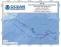
The 2021 North Atlantic Stepping Stones: New England and Corner Rise Seamounts expedition (EX-21-04) was a combined mapping and remotely operated vehicle (ROV) expedition to the seamounts of the Northwest Atlantic that took place between June 30 and July 29, 2021. Operations during this 30-day at sea expedition included a combination of ROV dives in support of NOAA Ocean Exploration and itís partner priorities as well as exploratory mapping operations targeting areas containing no or poor quality modern mapping data. The initial focus was on the U.S. Northeast Seamount and high seas areas, however, during the expedition weather altered the planned transect to outside Bermudan waters where three dives took place before rejoining the planned dive sites exploring a total of 19 seamounts and one canyon (Hydrographer) for water column exploration. During the expedition, 20 Deep Discoverer ROV dives were conducted from 300 m to 4187 m water depth for a total of 154 hours of bottom time, and surveyed using EM 304 multibeam sonar 54,710 square km over 30 days at sea. All data associated with this expedition have been archived and are publicly available through the NOAA Archives.
Expedition Data and Resources
| Expedition Summary Report (PDF - 5.17 MB) | Open | Click to open link |
| Mapping Summary Report (PDF - 1.75 MB) | Open | Click to open link |
| Ship Navigation Data (ASCII) | Download | Use zip utility to open file |
| Ship SCS/Sensor Data (ASCII) | Download | Use zip utility to open file |
| Ship SCS/Sensor Data (NetCDF) | Open | NetCDF file format: Special software needed to read |
| Bulk Data Download | Download | Use zip utility to open file |
| Shipboard CTDs | Download | Use zip utility to open file |
| Mapping Products | Download | Use zip utility to open file |
Submersible Data and Resources
| Dive Summaries | Download | Use zip utility to open file |
| Dive Tracks | Download | Use zip utility to open file |
| ROV Dive Event Logs | Open | Click to open link |
| Cruise Video Collection Self-Service Portal | Open | Click to open link |
| Specimens Collected During Dive Operations | Download | Click to open link |
| Submersible Navigation/Sensor Data (ASCII) | Download | Use zip utility to open file |
Collected Specimen Repositories
| Smithsonian National Museum of Natural History (Biological Samples) | Open | Click to visit repository website |
| Oregon State University's Marine Geology Repository | Open | Click to visit repository website |
Educational Resources
| Education Materials Collection | Open | Click to open Education Materials |
Links to Archived Data and Resources
| Water Column Sonar Archive Collection | Get Data | Click to Access Archive |
| Single-beam and Sub-bottom Data Archive Collection | Get Data | Click to Access Archive |
| Physical, Chemical, and Biological Archive Collection | Get Data | Click to Access Archive |
| Expedition Metadata | Open | Click to view Metadata in xml format |
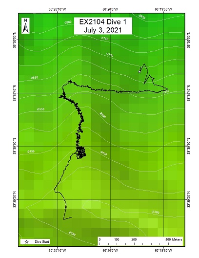
"North Bermuda Tritop"
Area
"North Bermuda Tritop"; Twin peaked seamount northeast ~ 270 miles NE of Bermuda (outside Bermuda EEZ)
Overview
| Date: | July 03, 2021 |
| Max Depth: | 2591.5 Meters |
| Bottom Time: | 4 Hours 28 Minutes 28 Seconds |
Purpose
The primary objective of this dive is to explore and characterize ecological conditions and geological features of this previously unexplored seamount.
Download & View Files
| Dive Summary Report (PDF - 2.13 MB) | View/Download | Requires Adobe Acrobat Reader to view the Dive Summary Report |
| Dive Track (KML - 77 KB) | View/Download | Requires Google Earth or equivalent client to view the Dive Track |
| ROV Ancillary Data (Zip - 11.1 MB) | Download | Link takes you to a public FTP server |
| ROV CTD/Sensor Data (Zip - 5.31 MB) | Download | Link takes you to a public FTP server |
| Camera Platform Sensor Data (Zip - 6.36 MB) | Download | Link takes you to a public FTP server |
| Low-Resolution Video Clips (Zip - 12.4 GB) | Download | Link takes you to a public FTP server |
| Underwater Still Images (Zip - 160 MB) | Download | Link takes you to a public FTP server |
| Dive Video Collection Self-Service Portal | Open | Link takes you to an online video discovery and access tool |
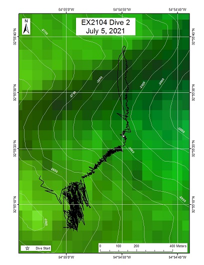
Congress Seamount South
Area
Congress Seamount South; High Seas east of Nashville Seamount. Potentially part of the New England Seamount Chain
Overview
| Date: | July 05, 2021 |
| Max Depth: | 2815.2 Meters |
| Bottom Time: | 4 Hours 54 Minutes 5 Seconds |
Purpose
Explore a previously unmapped and poorly explored seamount to see if there is a biological or geological connection between Congress Seamount and the New England Seamount or Corner Rise Seamount chains.
Download & View Files
| Dive Summary Report (PDF - 2.05 MB) | View/Download | Requires Adobe Acrobat Reader to view the Dive Summary Report |
| Dive Track (KML - 78.5 KB) | View/Download | Requires Google Earth or equivalent client to view the Dive Track |
| ROV Ancillary Data (Zip - 12 MB) | Download | Link takes you to a public FTP server |
| ROV CTD/Sensor Data (Zip - 5.76 MB) | Download | Link takes you to a public FTP server |
| Camera Platform Sensor Data (Zip - 6.62 MB) | Download | Link takes you to a public FTP server |
| Low-Resolution Video Clips (Zip - 13.5 GB) | Download | Link takes you to a public FTP server |
| Underwater Still Images (Zip - 174 MB) | Download | Link takes you to a public FTP server |
| Dive Video Collection Self-Service Portal | Open | Link takes you to an online video discovery and access tool |
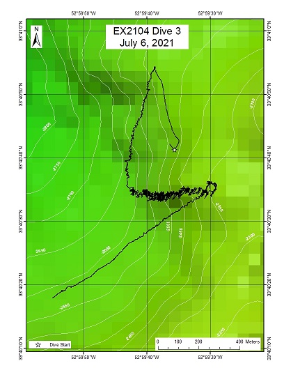
"Hopscotch" Seamount
Area
"Hopscotch" Seamount; South of Corner Rise Seamounts
Overview
| Date: | July 06, 2021 |
| Max Depth: | 2639.8 Meters |
| Bottom Time: | 4 Hours 49 Minutes 36 Seconds |
Purpose
First exploration of an unexplored and largely unmapped seamount to characterize the biological and geological habitats. This dive was primarily chosen for logistical purposes, but samples and data from here can help inform how the Corner Rise Seamounts, New England Seamounts, and other surrounding seamounts are connected.
Download & View Files
| Dive Summary Report (PDF - 2.07 MB) | View/Download | Requires Adobe Acrobat Reader to view the Dive Summary Report |
| Dive Track (KML - 79.4 KB) | View/Download | Requires Google Earth or equivalent client to view the Dive Track |
| ROV Ancillary Data (Zip - 11.4 MB) | Download | Link takes you to a public FTP server |
| ROV CTD/Sensor Data (Zip - 5.71 MB) | Download | Link takes you to a public FTP server |
| Camera Platform Sensor Data (Zip - 6.4 MB) | Download | Link takes you to a public FTP server |
| Low-Resolution Video Clips (Zip - 13.4 GB) | Download | Link takes you to a public FTP server |
| Underwater Still Images (Zip - 154 MB) | Download | Link takes you to a public FTP server |
| Dive Video Collection Self-Service Portal | Open | Link takes you to an online video discovery and access tool |
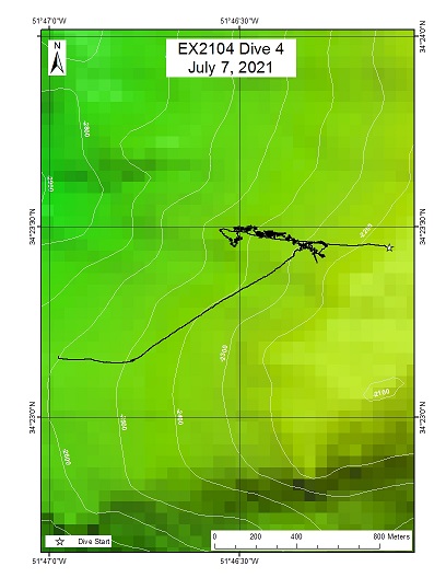
"Dumbbell" Seamount
Area
"Dumbbell" Seamount; Seamount within the Corner Rise Seamount Chain area
Overview
| Date: | July 07, 2021 |
| Max Depth: | 2411.9 Meters |
| Bottom Time: | 5 Hours 15 Minutes 39 Seconds |
Purpose
Exploration of a previously unexplored seamount.
Download & View Files
| Dive Summary Report (PDF - 2.87 MB) | View/Download | Requires Adobe Acrobat Reader to view the Dive Summary Report |
| Dive Track (KML - 78.4 KB) | View/Download | Requires Google Earth or equivalent client to view the Dive Track |
| ROV Ancillary Data (Zip - 12.1 MB) | Download | Link takes you to a public FTP server |
| ROV CTD/Sensor Data (Zip - 5.95 MB) | Download | Link takes you to a public FTP server |
| Camera Platform Sensor Data (Zip - 6.61 MB) | Download | Link takes you to a public FTP server |
| Low-Resolution Video Clips (Zip - 13.8 GB) | Download | Link takes you to a public FTP server |
| Underwater Still Images (Zip - 179 MB) | Download | Link takes you to a public FTP server |
| Dive Video Collection Self-Service Portal | Open | Link takes you to an online video discovery and access tool |
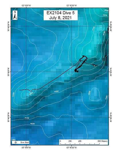
Rockaway Seamount
Area
Rockaway Seamount; Corner Rise Seamounts
Overview
| Date: | July 08, 2021 |
| Max Depth: | 4187.2 Meters |
| Bottom Time: | 3 Hours 11 Minutes 28 Seconds |
Purpose
Deep exploration of Rockaway Seamount to visualize the deep flank of this guyot, collect rock samples for aging and composition, and document the biological community present.
Download & View Files
| Dive Summary Report (PDF - 2.51 MB) | View/Download | Requires Adobe Acrobat Reader to view the Dive Summary Report |
| Dive Track (KML - 77.7 KB) | View/Download | Requires Google Earth or equivalent client to view the Dive Track |
| ROV Ancillary Data (Zip - 12.2 MB) | Download | Link takes you to a public FTP server |
| ROV CTD/Sensor Data (Zip - 6.21 MB) | Download | Link takes you to a public FTP server |
| Camera Platform Sensor Data (Zip - 6.51 MB) | Download | Link takes you to a public FTP server |
| Low-Resolution Video Clips (Zip - 13.5 GB) | Download | Link takes you to a public FTP server |
| Underwater Still Images (Zip - 112 MB) | Download | Link takes you to a public FTP server |
| Dive Video Collection Self-Service Portal | Open | Link takes you to an online video discovery and access tool |
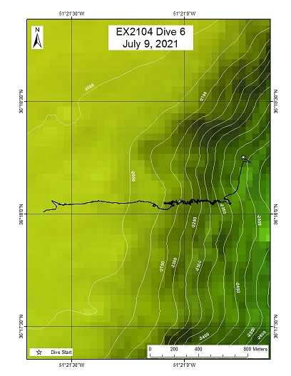
Castle Rock
Area
Castle Rock; Most northern seamount in the Corner Rise Seamount chain
Overview
| Date: | July 09, 2021 |
| Max Depth: | 2331.3 Meters |
| Bottom Time: | 5 Hours 36 Minutes 50 Seconds |
Purpose
Exploration of the Northern end of the Corner Rise Seamount Chain.
Download & View Files
| Dive Summary Report (PDF - 3.16 MB) | View/Download | Requires Adobe Acrobat Reader to view the Dive Summary Report |
| Dive Track (KML - 77 KB) | View/Download | Requires Google Earth or equivalent client to view the Dive Track |
| ROV Ancillary Data (Zip - 12.9 MB) | Download | Link takes you to a public FTP server |
| ROV CTD/Sensor Data (Zip - 5.74 MB) | Download | Link takes you to a public FTP server |
| Camera Platform Sensor Data (Zip - 6.52 MB) | Download | Link takes you to a public FTP server |
| Low-Resolution Video Clips (Zip - 13.6 GB) | Download | Link takes you to a public FTP server |
| Underwater Still Images (Zip - 224 MB) | Download | Link takes you to a public FTP server |
| Dive Video Collection Self-Service Portal | Open | Link takes you to an online video discovery and access tool |
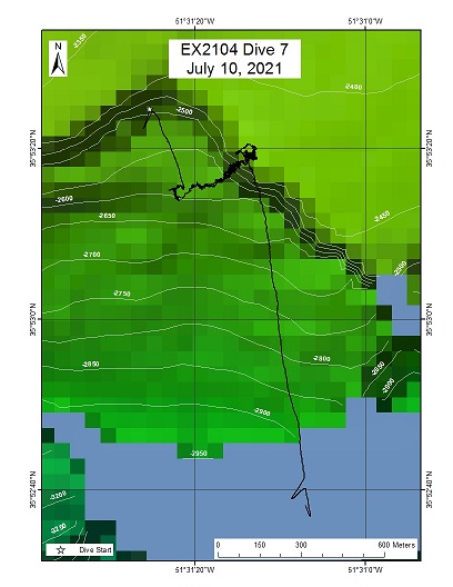
"Corner Rise 1"
Area
"Corner Rise 1"; Unnamed seamount within the North-West quadrant of the Corner Rise Seamount Complex
Overview
| Date: | July 10, 2021 |
| Max Depth: | 2593.7 Meters |
| Bottom Time: | 4 Hours 36 Minutes 14 Seconds |
Purpose
Explore an unexplored and unmapped seamount.
Download & View Files
| Dive Summary Report (PDF - 2.81 MB) | View/Download | Requires Adobe Acrobat Reader to view the Dive Summary Report |
| Dive Track (KML - 77.9 KB) | View/Download | Requires Google Earth or equivalent client to view the Dive Track |
| ROV Ancillary Data (Zip - 12.2 MB) | Download | Link takes you to a public FTP server |
| ROV CTD/Sensor Data (Zip - 5.78 MB) | Download | Link takes you to a public FTP server |
| Camera Platform Sensor Data (Zip - 5.93 MB) | Download | Link takes you to a public FTP server |
| Low-Resolution Video Clips (Zip - 12.7 GB) | Download | Link takes you to a public FTP server |
| Underwater Still Images (Zip - 170 MB) | Download | Link takes you to a public FTP server |
| Dive Video Collection Self-Service Portal | Open | Link takes you to an online video discovery and access tool |
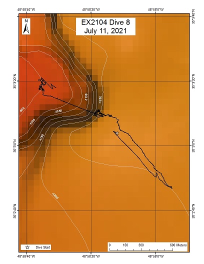
MacGregor Seamount
Area
MacGregor Seamount; Large seamount within the Eastern portion of the Corner Rise Seamount Complex
Overview
| Date: | July 11, 2021 |
| Max Depth: | 1272.1 Meters |
| Bottom Time: | 4 Hours 49 Minutes 57 Seconds |
Purpose
Explore an unexplored seamount.
Download & View Files
| Dive Summary Report (PDF - 2.45 MB) | View/Download | Requires Adobe Acrobat Reader to view the Dive Summary Report |
| Dive Track (KML - 79.8 KB) | View/Download | Requires Google Earth or equivalent client to view the Dive Track |
| ROV Ancillary Data (Zip - 11.5 MB) | Download | Link takes you to a public FTP server |
| ROV CTD/Sensor Data (Zip - 6.05 MB) | Download | Link takes you to a public FTP server |
| Camera Platform Sensor Data (Zip - 6.41 MB) | Download | Link takes you to a public FTP server |
| Low-Resolution Video Clips (Zip - 12.8 GB) | Download | Link takes you to a public FTP server |
| Underwater Still Images (Zip - 156 MB) | Download | Link takes you to a public FTP server |
| Dive Video Collection Self-Service Portal | Open | Link takes you to an online video discovery and access tool |
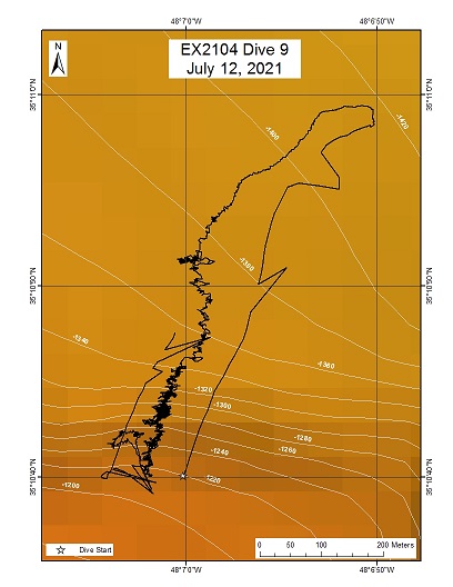
Yakutat Seamount - Shallow
Area
Yakutat Seamount - Shallow; Large seamount near the Eastern margin of the Corner Rise Seamount Complex
Overview
| Date: | July 12, 2021 |
| Max Depth: | 1365.6 Meters |
| Bottom Time: | 5 Hours 53 Minutes 22 Seconds |
Purpose
Explore an unexplored region of a large seamount.
Download & View Files
| Dive Summary Report (PDF - 3.7 MB) | View/Download | Requires Adobe Acrobat Reader to view the Dive Summary Report |
| Dive Track (KML - 80.4 KB) | View/Download | Requires Google Earth or equivalent client to view the Dive Track |
| ROV Ancillary Data (Zip - 7.31 MB) | Download | Link takes you to a public FTP server |
| ROV CTD/Sensor Data (Zip - 6.1 MB) | Download | Link takes you to a public FTP server |
| Camera Platform Sensor Data (Zip - 6.36 MB) | Download | Link takes you to a public FTP server |
| Low-Resolution Video Clips (Zip - 13.2 GB) | Download | Link takes you to a public FTP server |
| Underwater Still Images (Zip - 252 MB) | Download | Link takes you to a public FTP server |
| Dive Video Collection Self-Service Portal | Open | Link takes you to an online video discovery and access tool |
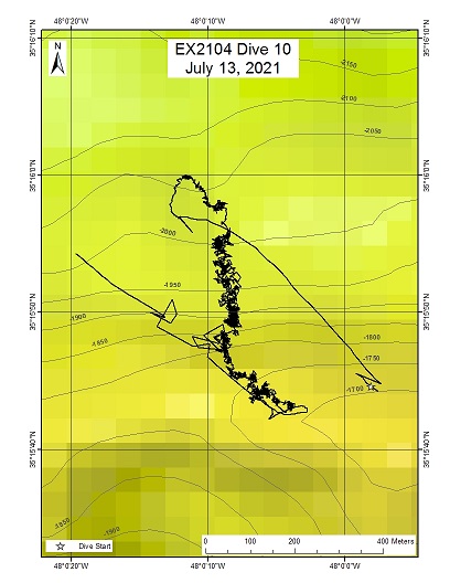
Yakutat Seamount - Deep
Area
Yakutat Seamount - Deep; Large seamount near the Eastern margin of the Corner Rise Seamount Complex
Overview
| Date: | July 13, 2021 |
| Max Depth: | 1982.9 Meters |
| Bottom Time: | 5 Hours 36 Minutes 23 Seconds |
Purpose
Explore an unexplored region of a large seamount.
Download & View Files
| Dive Summary Report (PDF - 2.61 MB) | View/Download | Requires Adobe Acrobat Reader to view the Dive Summary Report |
| Dive Track (KML - 78.1 KB) | View/Download | Requires Google Earth or equivalent client to view the Dive Track |
| ROV Ancillary Data (Zip - 12.5 MB) | Download | Link takes you to a public FTP server |
| ROV CTD/Sensor Data (Zip - 6.38 MB) | Download | Link takes you to a public FTP server |
| Camera Platform Sensor Data (Zip - 6.7 MB) | Download | Link takes you to a public FTP server |
| Low-Resolution Video Clips (Zip - 13.5 GB) | Download | Link takes you to a public FTP server |
| Underwater Still Images (Zip - 231 MB) | Download | Link takes you to a public FTP server |
| Dive Video Collection Self-Service Portal | Open | Link takes you to an online video discovery and access tool |
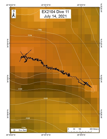
Caloosahatchee Seamount
Area
Caloosahatchee Seamount; Large seamount near the center of the Corner Rise Seamount Complex
Overview
| Date: | July 14, 2021 |
| Max Depth: | 1247.1 Meters |
| Bottom Time: | 3 Hours 14 Minutes 21 Seconds |
Purpose
Explore an unexplored region of a large seamount.
Download & View Files
| Dive Summary Report (PDF - 2.58 MB) | View/Download | Requires Adobe Acrobat Reader to view the Dive Summary Report |
| Dive Track (KML - 83.5 KB) | View/Download | Requires Google Earth or equivalent client to view the Dive Track |
| ROV Ancillary Data (Zip - 8.85 MB) | Download | Link takes you to a public FTP server |
| ROV CTD/Sensor Data (Zip - 4.3 MB) | Download | Link takes you to a public FTP server |
| Camera Platform Sensor Data (Zip - 4.33 MB) | Download | Link takes you to a public FTP server |
| Low-Resolution Video Clips (Zip - 9.09 GB) | Download | Link takes you to a public FTP server |
| Underwater Still Images (Zip - 169 MB) | Download | Link takes you to a public FTP server |
| Dive Video Collection Self-Service Portal | Open | Link takes you to an online video discovery and access tool |
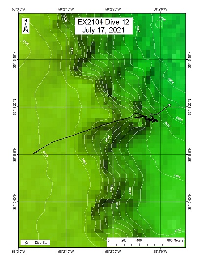
"Y" seamount (unmapped, unnamed)
Area
"Y" seamount (unmapped, unnamed); New England Seamounts, Eastern End
Overview
| Date: | July 17, 2021 |
| Max Depth: | 2806.8 Meters |
| Bottom Time: | 4 Hours 58 Minutes 18 Seconds |
Purpose
Explore new seamount area.
Download & View Files
| Dive Summary Report (PDF - 2.83 MB) | View/Download | Requires Adobe Acrobat Reader to view the Dive Summary Report |
| Dive Track (KML - 77.8 KB) | View/Download | Requires Google Earth or equivalent client to view the Dive Track |
| ROV Ancillary Data (Zip - 12.7 MB) | Download | Link takes you to a public FTP server |
| ROV CTD/Sensor Data (Zip - 6.24 MB) | Download | Link takes you to a public FTP server |
| Camera Platform Sensor Data (Zip - 6.31 MB) | Download | Link takes you to a public FTP server |
| Low-Resolution Video Clips (Zip - 13.5 GB) | Download | Link takes you to a public FTP server |
| Underwater Still Images (Zip - 215 MB) | Download | Link takes you to a public FTP server |
| Dive Video Collection Self-Service Portal | Open | Link takes you to an online video discovery and access tool |
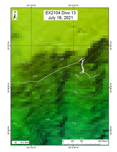
"Near Hodgsen" seamount (unmapped, unnamed)
Area
"Near Hodgsen" seamount (unmapped, unnamed); New England Seamounts, Eastern End
Overview
| Date: | July 18, 2021 |
| Max Depth: | 2531.2 Meters |
| Bottom Time: | 5 Hours 14 Minutes 11 Seconds |
Purpose
Explore new seamount area.
Download & View Files
| Dive Summary Report (PDF - 2.12 MB) | View/Download | Requires Adobe Acrobat Reader to view the Dive Summary Report |
| Dive Track (KML - 79.2 KB) | View/Download | Requires Google Earth or equivalent client to view the Dive Track |
| ROV Ancillary Data (Zip - 12 MB) | Download | Link takes you to a public FTP server |
| ROV CTD/Sensor Data (Zip - 6.48 MB) | Download | Link takes you to a public FTP server |
| Camera Platform Sensor Data (Zip - 6.28 MB) | Download | Link takes you to a public FTP server |
| Low-Resolution Video Clips (Zip - 13.7 GB) | Download | Link takes you to a public FTP server |
| Underwater Still Images (Zip - 217 MB) | Download | Link takes you to a public FTP server |
| Dive Video Collection Self-Service Portal | Open | Link takes you to an online video discovery and access tool |
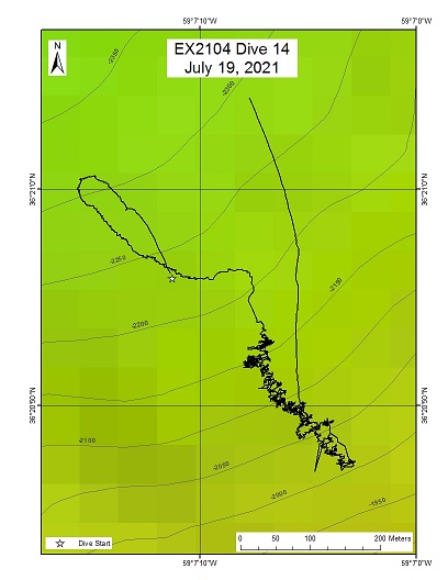
"Seven" Seamount (formally "Baby")
Area
"Seven" Seamount (formally "Baby"); Mid area of the New England Seamounts
Overview
| Date: | July 19, 2021 |
| Max Depth: | 2143.9 Meters |
| Bottom Time: | 5 Hours 36 Minutes 8 Seconds |
Purpose
Exploration of an unmapped and unnamed seamount.
Download & View Files
| Dive Summary Report (PDF - 3.37 MB) | View/Download | Requires Adobe Acrobat Reader to view the Dive Summary Report |
| Dive Track (KML - 76.1 KB) | View/Download | Requires Google Earth or equivalent client to view the Dive Track |
| ROV Ancillary Data (Zip - 7 MB) | Download | Link takes you to a public FTP server |
| ROV CTD/Sensor Data (Zip - 6.24 MB) | Download | Link takes you to a public FTP server |
| Camera Platform Sensor Data (Zip - 6.14 MB) | Download | Link takes you to a public FTP server |
| Low-Resolution Video Clips (Zip - 13.7 GB) | Download | Link takes you to a public FTP server |
| Underwater Still Images (Zip - 243 MB) | Download | Link takes you to a public FTP server |
| Dive Video Collection Self-Service Portal | Open | Link takes you to an online video discovery and access tool |
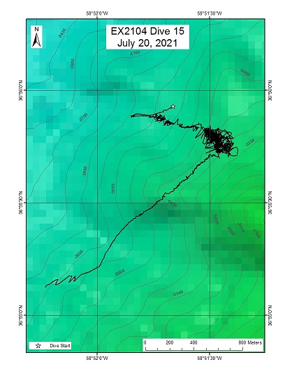
Allegheny Seamount
Area
Allegheny Seamount; Easterm end of the New England Seamount Chain
Overview
| Date: | July 20, 2021 |
| Max Depth: | 3446.6 Meters |
| Bottom Time: | 3 Hours 34 Minutes 13 Seconds |
Purpose
Explore deep Allegheny seamount.
Download & View Files
| Dive Summary Report (PDF - 3.31 MB) | View/Download | Requires Adobe Acrobat Reader to view the Dive Summary Report |
| Dive Track (KML - 77.5 KB) | View/Download | Requires Google Earth or equivalent client to view the Dive Track |
| ROV Ancillary Data (Zip - 6.87 MB) | Download | Link takes you to a public FTP server |
| ROV CTD/Sensor Data (Zip - 5.8 MB) | Download | Link takes you to a public FTP server |
| Camera Platform Sensor Data (Zip - 5.94 MB) | Download | Link takes you to a public FTP server |
| Low-Resolution Video Clips (Zip - 12.6 GB) | Download | Link takes you to a public FTP server |
| Underwater Still Images (Zip - 159 MB) | Download | Link takes you to a public FTP server |
| Dive Video Collection Self-Service Portal | Open | Link takes you to an online video discovery and access tool |
Gosnold Seamount
Area
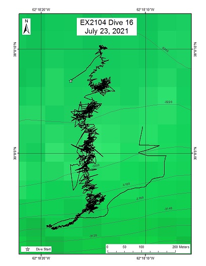
Gosnold Seamount; Saddle area between the North and south peaks of Gosnold
Overview
| Date: | July 23, 2021 |
| Max Depth: | 3237.9 Meters |
| Bottom Time: | 3 Hours 55 Minutes 1 Seconds |
Purpose
Explore saddle area at deeper depths than previous explorations on Gosnold.
Download & View Files
| Dive Summary Report (PDF - 4.04 MB) | View/Download | Requires Adobe Acrobat Reader to view the Dive Summary Report |
| Dive Track (KML - 81.1 KB) | View/Download | Requires Google Earth or equivalent client to view the Dive Track |
| ROV Ancillary Data (Zip - 13.5 MB) | Download | Link takes you to a public FTP server |
| ROV CTD/Sensor Data (Zip - 6.13 MB) | Download | Link takes you to a public FTP server |
| Camera Platform Sensor Data (Zip - 6.07 MB) | Download | Link takes you to a public FTP server |
| Low-Resolution Video Clips (Zip - 13.3 GB) | Download | Link takes you to a public FTP server |
| Underwater Still Images (Zip - 206 MB) | Download | Link takes you to a public FTP server |
| Dive Video Collection Self-Service Portal | Open | Link takes you to an online video discovery and access tool |
Gosnold Seamount (Shallow)
Area
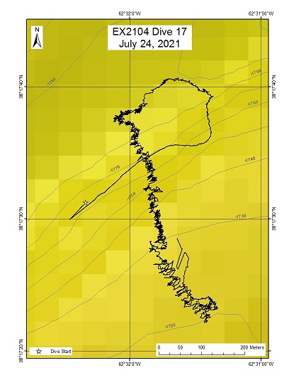
Gosnold Seamount (Shallow); Summit area, NW corner of seamount
Overview
| Date: | July 24, 2021 |
| Max Depth: | 1782.8 Meters |
| Bottom Time: | 4 Hours 48 Minutes 4 Seconds |
Purpose
Explored a new area of a previously explored seamount.
Download & View Files
| Dive Summary Report (PDF - 3.11 MB) | View/Download | Requires Adobe Acrobat Reader to view the Dive Summary Report |
| Dive Track (KML - 78.1 KB) | View/Download | Requires Google Earth or equivalent client to view the Dive Track |
| ROV Ancillary Data (Zip - 11.5 MB) | Download | Link takes you to a public FTP server |
| ROV CTD/Sensor Data (Zip - 5.18 MB) | Download | Link takes you to a public FTP server |
| Camera Platform Sensor Data (Zip - 5.47 MB) | Download | Link takes you to a public FTP server |
| Low-Resolution Video Clips (Zip - 11.8 GB) | Download | Link takes you to a public FTP server |
| Underwater Still Images (Zip - 167 MB) | Download | Link takes you to a public FTP server |
| Dive Video Collection Self-Service Portal | Open | Link takes you to an online video discovery and access tool |
"Asterina" Seamount
Area
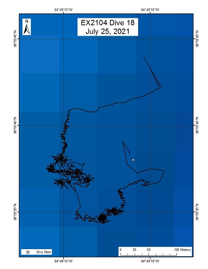
"Asterina" Seamount; Western end of the New England Seamount Chain, part of a series of three deep seamounts
Overview
| Date: | July 25, 2021 |
| Max Depth: | 3791.9 Meters |
| Bottom Time: | 0 Hours 39 Minutes 32 Seconds |
Purpose
Explore a seamount.
Download & View Files
| Dive Summary Report (PDF - 2.26 MB) | View/Download | Requires Adobe Acrobat Reader to view the Dive Summary Report |
| Dive Track (KML - 48.4 KB) | View/Download | Requires Google Earth or equivalent client to view the Dive Track |
| ROV Ancillary Data (Zip - 9.37 MB) | Download | Link takes you to a public FTP server |
| ROV CTD/Sensor Data (Zip - 3.89 MB) | Download | Link takes you to a public FTP server |
| Camera Platform Sensor Data (Zip - 4.03 MB) | Download | Link takes you to a public FTP server |
| Low-Resolution Video Clips (Zip - 9.35 GB) | Download | Link takes you to a public FTP server |
| Underwater Still Images (Zip - 71.8 MB) | Download | Link takes you to a public FTP server |
| Dive Video Collection Self-Service Portal | Open | Link takes you to an online video discovery and access tool |
Retriever Seamount
Area
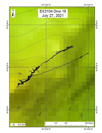
Retriever Seamount; Northern summit pinnacle
Overview
| Date: | July 27, 2021 |
| Max Depth: | 1935.8 Meters |
| Bottom Time: | 4 Hours 49 Minutes 15 Seconds |
Purpose
Shallowest dive to date on Retriever, exploring a cone feature on the top of the plateau.
Download & View Files
| Dive Summary Report (PDF - 2.6 MB) | View/Download | Requires Adobe Acrobat Reader to view the Dive Summary Report |
| Dive Track (KML - 79.5 KB) | View/Download | Requires Google Earth or equivalent client to view the Dive Track |
| ROV Ancillary Data (Zip - 12.5 MB) | Download | Link takes you to a public FTP server |
| ROV CTD/Sensor Data (Zip - 6.1 MB) | Download | Link takes you to a public FTP server |
| Camera Platform Sensor Data (Zip - 6.6 MB) | Download | Link takes you to a public FTP server |
| Low-Resolution Video Clips (Zip - 13.8 GB) | Download | Link takes you to a public FTP server |
| Underwater Still Images (Zip - 260 MB) | Download | Link takes you to a public FTP server |
| Dive Video Collection Self-Service Portal | Open | Link takes you to an online video discovery and access tool |
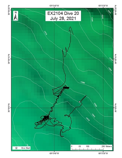
Hydrographer Canyon
Area
Hydrographer Canyon; Canyon on the northeastern shelf edge of the U.S.
Overview
| Date: | July 28, 2021 |
| Max Depth: | n/a |
| Bottom Time: | n/a |
Purpose
Explore the water column in Hydrographer Canyon.
Download & View Files
| Dive Summary Report (PDF - 2.1 MB) | View/Download | Requires Adobe Acrobat Reader to view the Dive Summary Report |
| Dive Track (KML - 78.7 KB) | View/Download | Requires Google Earth or equivalent client to view the Dive Track |
| ROV Ancillary Data (Zip - 9.65 MB) | Download | Link takes you to a public FTP server |
| ROV CTD/Sensor Data (Zip - 5.07 MB) | Download | Link takes you to a public FTP server |
| Camera Platform Sensor Data (Zip - 5.54 MB) | Download | Link takes you to a public FTP server |
| Low-Resolution Video Clips (Zip - 10.8 GB) | Download | Link takes you to a public FTP server |
| Underwater Still Images (Zip - 196 MB) | Download | Link takes you to a public FTP server |
| Dive Video Collection Self-Service Portal | Open | Link takes you to an online video discovery and access tool |

