
Windows to the Deep 2021: Blake Plateau
Vessel: NOAA Ship Okeanos Explorer; Expedition Dates: October 26, 2021 to November 15, 2021
Ports: Charleston, NC to Port Canaveral, FL
Project Principals: Matt Dornback, NOAA/OAR/OER (Expedition Coordinator); Derek Sowers, NOAA/OAR/OER (Mapping Lead)
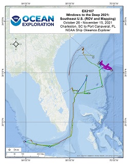
The Windows to the Deep 2021: Southeast U.S. ROV and Mapping expedition (EX-21-07) was a combined mapping and remotely operated vehicle (ROV) expedition to the Blake Plateau and Florida Straits that took place between October 26 and November 15, 2021. Operations during this 21-days at sea expedition included a combination of ROV dives in support of NOAA Ocean Exploration and its partner priorities. The primary focus of this expedition was the Blake Plateau, including its escarpment, off the coast of the Southeast U.S., but three dives were also conducted in the western and central Florida Straits due to weather conditions. Overall, 14 dives were completed, including two explorations of the water column, several dives to mound and ridgelike structures likely to be bioherms, two deeper dives to explore the steep Blake Escarpment, and one dive to document a lone sinkhole in the southeast region of the Blake Plateau. ROV dives were conducted from 300 m to 3650 meters water depth for a total of 47 hours of bottom time, and 15,800 square km were mapped using EM 304 multibeam sonar . All data associated with this expedition have been archived and are publicly available through the NOAA Archives.
Expedition Data and Resources
| Expedition Summary Report (PDF - 2.82 MB) | Open | Click to open link |
| Ship Navigation Data (ASCII) | Download | Use zip utility to open file |
| Ship SCS/Sensor Data (ASCII) | Download | Use zip utility to open file |
| Ship SCS/Sensor Data (NetCDF) | Open | NetCDF file format: Special software needed to read |
| Bulk Data Download | Download | Use zip utility to open file |
| Shipboard CTDs | Download | Use zip utility to open file |
| Mapping Products | Download | Use zip utility to open file |
Submersible Data and Resources
| Dive Summaries | Download | Use zip utility to open file |
| Dive Tracks | Download | Use zip utility to open file |
| ROV Dive Event Logs | Open | Click to open link |
| Cruise Video Collection Self-Service Portal | Open | Click to open link |
| Specimens Collected During Dive Operations | Download | Click to open link |
| Submersible Navigation/Sensor Data (ASCII) | Download | Use zip utility to open file |
Collected Specimen Repositories
| Smithsonian National Museum of Natural History (Biological Samples) | Open | Click to visit repository website |
| Oregon State University's Marine Geology Repository | Open | Click to visit repository website |
Educational Resources
| Education Materials Collection | Open | Click to open Education Materials |
Links to Archived Data and Resources
| Water Column Sonar Archive Collection | Get Data | Click to Access Archive |
| Single-beam and Sub-bottom Data Archive Collection | Get Data | Click to Access Archive |
| Physical, Chemical, and Biological Archive Collection | Get Data | Click to Access Archive |
| Expedition Metadata | Open | Click to view Metadata in xml format |
Reef Tracts
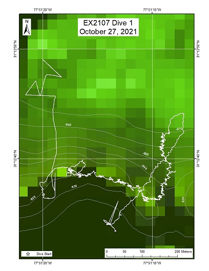
Area
Reef Tracts; Row of 65 m mounds on the Blake Plateau
Overview
| Date: | October 27, 2021 |
| Max Depth: | 867.6 Meters |
| Bottom Time: | 6 Hours 10 Minutes 16 Seconds |
Purpose
Exploration and collections
Download & View Files
| Dive Summary Report (PDF - 6.66 MB) | View/Download | Requires Adobe Acrobat Reader to view the Dive Summary Report |
| Dive Track (KML - 79.6 KB) | View/Download | Requires Google Earth or equivalent client to view the Dive Track |
| ROV Ancillary Data (Zip - 15.7 MB) | Download | Link takes you to a public FTP server |
| ROV CTD/Sensor Data (Zip - 6.26 MB) | Download | Link takes you to a public FTP server |
| Camera Platform Sensor Data (Zip - 6.26 MB) | Download | Link takes you to a public FTP server |
| Low-Resolution Video Clips (Zip - 13 GB) | Download | Link takes you to a public FTP server |
| Underwater Still Images (Zip - 166 MB) | Download | Link takes you to a public FTP server |
| Dive Video Collection Self-Service Portal | Open | Link takes you to an online video discovery and access tool |
Bloody Marsh
Area
Bloody Marsh; Pavement area on the Blake Plateau where a bathymetric anomaly was found on multibeam collected by OKEX over the summer, 2021
Overview
| Date: | October 28, 2021 |
| Max Depth: | 475.1 Meters |
| Bottom Time: | 6 Hours 9 Minutes 47 Seconds |
Purpose
On the hunt for the SS Bloody Marsh, no collections
Download & View Files
| Dive Summary Report (PDF - .894 MB) | View/Download | Requires Adobe Acrobat Reader to view the Dive Summary Report |
| Low-Resolution Video Clips (Zip - 13.3 GB) | Download | Link takes you to a public FTP server |
| Underwater Still Images (Zip - 154 MB) | Download | Link takes you to a public FTP server |
| Dive Video Collection Self-Service Portal | Open | Link takes you to an online video discovery and access tool |
Midwater North
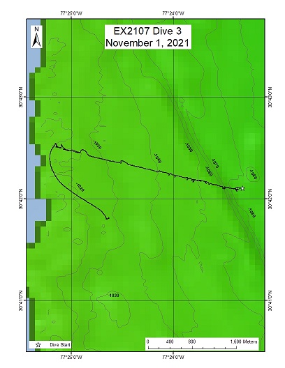
Area
Midwater North; Eastern shelf break, northern Blake Plateau
Overview
| Date: | November 01, 2021 |
| Max Depth: | 1016.2 Meters |
| Bottom Time: | 1 Hours 11 Minutes 2 Seconds |
Purpose
Midwater Transects and collections
Download & View Files
| Dive Summary Report (PDF - 3.75 MB) | View/Download | Requires Adobe Acrobat Reader to view the Dive Summary Report |
| Dive Track (KML - 78.7 KB) | View/Download | Requires Google Earth or equivalent client to view the Dive Track |
| ROV Ancillary Data (Zip - 13.3 MB) | Download | Link takes you to a public FTP server |
| ROV CTD/Sensor Data (Zip - 6.28 MB) | Download | Link takes you to a public FTP server |
| Camera Platform Sensor Data (Zip - 6.28 MB) | Download | Link takes you to a public FTP server |
| Low-Resolution Video Clips (Zip - 13.6 GB) | Download | Link takes you to a public FTP server |
| Underwater Still Images (Zip - 107 MB) | Download | Link takes you to a public FTP server |
| Dive Video Collection Self-Service Portal | Open | Link takes you to an online video discovery and access tool |
Deep Mound - 1
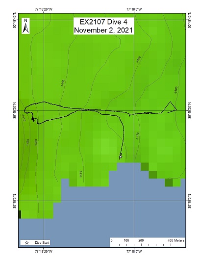
Area
Deep Mound - 1; Along the eastern Slope of the shelf break of the Blake Plateau
Overview
| Date: | November 02, 2021 |
| Max Depth: | 1400 Meters |
| Bottom Time: | n/a |
Purpose
Exploration of a possible deep reef, collections
Download & View Files
| Dive Summary Report (PDF - .834 MB) | View/Download | Requires Adobe Acrobat Reader to view the Dive Summary Report |
| Dive Track (KML - 84.6 KB) | View/Download | Requires Google Earth or equivalent client to view the Dive Track |
| ROV Ancillary Data (Zip - 3.64 MB) | Download | Link takes you to a public FTP server |
| ROV CTD/Sensor Data (Zip - 1.87 MB) | Download | Link takes you to a public FTP server |
| Camera Platform Sensor Data (Zip - 1.87 MB) | Download | Link takes you to a public FTP server |
| Low-Resolution Video Clips (Zip - 4.2 GB) | Download | Link takes you to a public FTP server |
| Underwater Still Images (Zip - 12.2 MB) | Download | Link takes you to a public FTP server |
| Dive Video Collection Self-Service Portal | Open | Link takes you to an online video discovery and access tool |
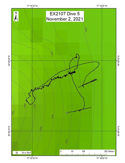
Deep Mound (Attempt 2- repeat of Dive 04)
Area
Deep Mound (Attempt 2- repeat of Dive 04); Along the eastern slope of the shelf break of the Blake Plateau
Overview
| Date: | November 02, 2021 |
| Max Depth: | 1413.8 Meters |
| Bottom Time: | 3 Hours 16 Minutes 44 Seconds |
Purpose
Exploration and collections
Download & View Files
| Dive Summary Report (PDF - 3.81 MB) | View/Download | Requires Adobe Acrobat Reader to view the Dive Summary Report |
| Dive Track (KML - 79.7 KB) | View/Download | Requires Google Earth or equivalent client to view the Dive Track |
| ROV Ancillary Data (Zip - 9.68 MB) | Download | Link takes you to a public FTP server |
| ROV CTD/Sensor Data (Zip - 3.57 MB) | Download | Link takes you to a public FTP server |
| Camera Platform Sensor Data (Zip - 3.57 MB) | Download | Link takes you to a public FTP server |
| Low-Resolution Video Clips (Zip - 8.4 GB) | Download | Link takes you to a public FTP server |
| Underwater Still Images (Zip - 114 MB) | Download | Link takes you to a public FTP server |
| Dive Video Collection Self-Service Portal | Open | Link takes you to an online video discovery and access tool |
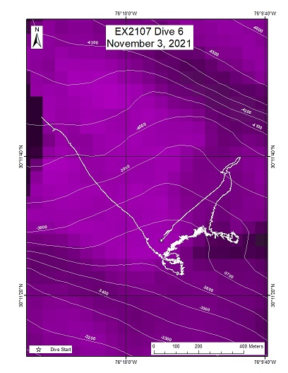
Blake Spur Wall
Area
Blake Spur Wall; Edge of the Blake Spur
Overview
| Date: | November 03, 2021 |
| Max Depth: | 3650.3 Meters |
| Bottom Time: | 3 Hours 5 Minutes 20 Seconds |
Purpose
Exploration and Collections along a steep wall
Download & View Files
| Dive Summary Report (PDF - 3.59 MB) | View/Download | Requires Adobe Acrobat Reader to view the Dive Summary Report |
| Dive Track (KML - 79.5 KB) | View/Download | Requires Google Earth or equivalent client to view the Dive Track |
| ROV Ancillary Data (Zip - 12.8 MB) | Download | Link takes you to a public FTP server |
| ROV CTD/Sensor Data (Zip - 6.08 MB) | Download | Link takes you to a public FTP server |
| Camera Platform Sensor Data (Zip - 6.08 MB) | Download | Link takes you to a public FTP server |
| Low-Resolution Video Clips (Zip - 12.7 GB) | Download | Link takes you to a public FTP server |
| Underwater Still Images (Zip - 135 MB) | Download | Link takes you to a public FTP server |
| Dive Video Collection Self-Service Portal | Open | Link takes you to an online video discovery and access tool |
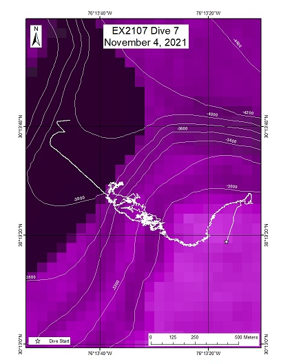
Blake Spur Canyon - Blake Plateau
Area
Blake Spur Canyon - Blake Plateau; The a small canyon on wall of the Blake Spur
Overview
| Date: | November 04, 2021 |
| Max Depth: | 3335.6 Meters |
| Bottom Time: | 1 Hours 7 Minutes 7 Seconds |
Purpose
Exploration
Download & View Files
| Dive Summary Report (PDF - 2.24 MB) | View/Download | Requires Adobe Acrobat Reader to view the Dive Summary Report |
| Dive Track (KML - 77.7 KB) | View/Download | Requires Google Earth or equivalent client to view the Dive Track |
| ROV Ancillary Data (Zip - 12 MB) | Download | Link takes you to a public FTP server |
| ROV CTD/Sensor Data (Zip - 6.15 MB) | Download | Link takes you to a public FTP server |
| Camera Platform Sensor Data (Zip - 6.15 MB) | Download | Link takes you to a public FTP server |
| Low-Resolution Video Clips (Zip - 13.5 GB) | Download | Link takes you to a public FTP server |
| Underwater Still Images (Zip - 86 MB) | Download | Link takes you to a public FTP server |
| Dive Video Collection Self-Service Portal | Open | Link takes you to an online video discovery and access tool |
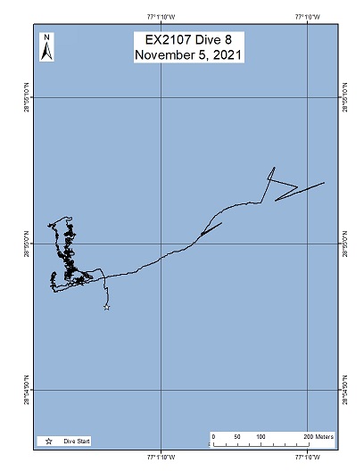
Sinkhole
Area
Sinkhole; Sinkhole on the Blake Plateau
Overview
| Date: | November 05, 2021 |
| Max Depth: | 1203.5 Meters |
| Bottom Time: | 2 Hours 58 Minutes 28 Seconds |
Purpose
Explorations - geological samples
Download & View Files
| Dive Summary Report (PDF - 4.09 MB) | View/Download | Requires Adobe Acrobat Reader to view the Dive Summary Report |
| Dive Track (KML - 75.6 KB) | View/Download | Requires Google Earth or equivalent client to view the Dive Track |
| ROV Ancillary Data (Zip - 9.77 MB) | Download | Link takes you to a public FTP server |
| ROV CTD/Sensor Data (Zip - 3.79 MB) | Download | Link takes you to a public FTP server |
| Camera Platform Sensor Data (Zip - 3.79 MB) | Download | Link takes you to a public FTP server |
| Low-Resolution Video Clips (Zip - 8.1 GB) | Download | Link takes you to a public FTP server |
| Underwater Still Images (Zip - 112 MB) | Download | Link takes you to a public FTP server |
| Dive Video Collection Self-Service Portal | Open | Link takes you to an online video discovery and access tool |
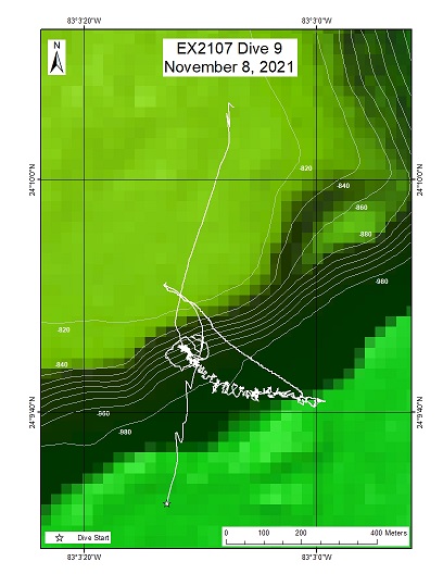
Tortugas Scarp
Area
Tortugas Scarp; Tortugas Valley - south of Dry Tortugas
Overview
| Date: | November 08, 2021 |
| Max Depth: | 982.1 Meters |
| Bottom Time: | 4 Hours 27 Minutes 29 Seconds |
Purpose
Exploration and collections
Download & View Files
| Dive Summary Report (PDF - 2.73 MB) | View/Download | Requires Adobe Acrobat Reader to view the Dive Summary Report |
| Dive Track (KML - 78 KB) | View/Download | Requires Google Earth or equivalent client to view the Dive Track |
| ROV Ancillary Data (Zip - 10.5 MB) | Download | Link takes you to a public FTP server |
| ROV CTD/Sensor Data (Zip - 5.37 MB) | Download | Link takes you to a public FTP server |
| Camera Platform Sensor Data (Zip - 5.37 MB) | Download | Link takes you to a public FTP server |
| Low-Resolution Video Clips (Zip - 11 GB) | Download | Link takes you to a public FTP server |
| Underwater Still Images (Zip - 193 MB) | Download | Link takes you to a public FTP server |
| Dive Video Collection Self-Service Portal | Open | Link takes you to an online video discovery and access tool |
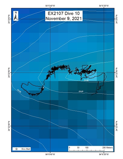
Shark Fin
Area
Shark Fin; Steep ridge
Overview
| Date: | November 09, 2021 |
| Max Depth: | 2456.6 Meters |
| Bottom Time: | 4 Hours 55 Minutes 41 Seconds |
Purpose
Exploration and collections
Download & View Files
| Dive Summary Report (PDF - 5.46 MB) | View/Download | Requires Adobe Acrobat Reader to view the Dive Summary Report |
| Dive Track (KML - 77.6 KB) | View/Download | Requires Google Earth or equivalent client to view the Dive Track |
| ROV Ancillary Data (Zip - 12.4 MB) | Download | Link takes you to a public FTP server |
| ROV CTD/Sensor Data (Zip - 5.98 MB) | Download | Link takes you to a public FTP server |
| Camera Platform Sensor Data (Zip - 5.98 MB) | Download | Link takes you to a public FTP server |
| Low-Resolution Video Clips (Zip - 13.4 GB) | Download | Link takes you to a public FTP server |
| Underwater Still Images (Zip - 173 MB) | Download | Link takes you to a public FTP server |
| Dive Video Collection Self-Service Portal | Open | Link takes you to an online video discovery and access tool |
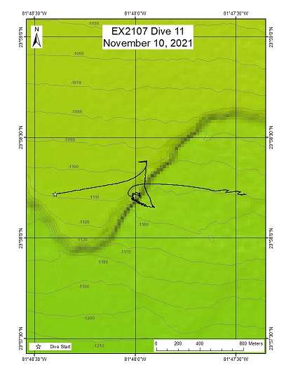
Key West Scarp
Area
Key West Scarp; South of Key West on Mitchell Escarpment
Overview
| Date: | November 10, 2021 |
| Max Depth: | 1151.5 Meters |
| Bottom Time: | 5 Hours 38 Minutes 13 Seconds |
Purpose
Exploration and collections
Download & View Files
| Dive Summary Report (PDF - 6.75 MB) | View/Download | Requires Adobe Acrobat Reader to view the Dive Summary Report |
| Dive Track (KML - 79.6 KB) | View/Download | Requires Google Earth or equivalent client to view the Dive Track |
| ROV Ancillary Data (Zip - 11.7 MB) | Download | Link takes you to a public FTP server |
| ROV CTD/Sensor Data (Zip - 6.16 MB) | Download | Link takes you to a public FTP server |
| Camera Platform Sensor Data (Zip - 6.16 MB) | Download | Link takes you to a public FTP server |
| Low-Resolution Video Clips (Zip - 13.4 GB) | Download | Link takes you to a public FTP server |
| Underwater Still Images (Zip - 191 MB) | Download | Link takes you to a public FTP server |
| Dive Video Collection Self-Service Portal | Open | Link takes you to an online video discovery and access tool |
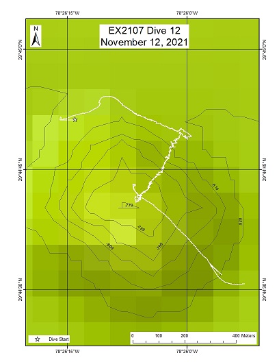
Knolls North
Area
Knolls North; Coral Mounds
Overview
| Date: | November 12, 2021 |
| Max Depth: | 815.2 Meters |
| Bottom Time: | 2 Hours 18 Minutes 24 Seconds |
Purpose
Coral Exploration
Download & View Files
| Dive Summary Report (PDF - 2.89 MB) | View/Download | Requires Adobe Acrobat Reader to view the Dive Summary Report |
| Dive Track (KML - 84.3 KB) | View/Download | Requires Google Earth or equivalent client to view the Dive Track |
| ROV Ancillary Data (Zip - 7.08 MB) | Download | Link takes you to a public FTP server |
| ROV CTD/Sensor Data (Zip - 3.18 MB) | Download | Link takes you to a public FTP server |
| Camera Platform Sensor Data (Zip - 3.18 MB) | Download | Link takes you to a public FTP server |
| Low-Resolution Video Clips (Zip - 6.3 GB) | Download | Link takes you to a public FTP server |
| Underwater Still Images (Zip - 162 MB) | Download | Link takes you to a public FTP server |
| Dive Video Collection Self-Service Portal | Open | Link takes you to an online video discovery and access tool |
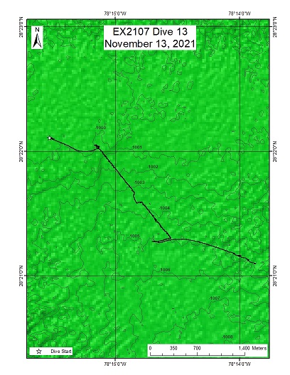
Midwater South
Area
Midwater South; Southern Blake Plateau
Overview
| Date: | November 13, 2021 |
| Max Depth: | n/a |
| Bottom Time: | n/a |
Purpose
Midwater Transects and collections
Download & View Files
| Dive Summary Report (PDF - 1.1 MB) | View/Download | Requires Adobe Acrobat Reader to view the Dive Summary Report |
| Dive Track (KML - 74.3 KB) | View/Download | Requires Google Earth or equivalent client to view the Dive Track |
| ROV Ancillary Data (Zip - 5.91 MB) | Download | Link takes you to a public FTP server |
| ROV CTD/Sensor Data (Zip - 2.77 MB) | Download | Link takes you to a public FTP server |
| Camera Platform Sensor Data (Zip - 2.77 MB) | Download | Link takes you to a public FTP server |
| Low-Resolution Video Clips (Zip - 6.7 GB) | Download | Link takes you to a public FTP server |
| Underwater Still Images (Zip - 50.3 MB) | Download | Link takes you to a public FTP server |
| Dive Video Collection Self-Service Portal | Open | Link takes you to an online video discovery and access tool |
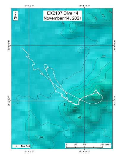
Million Mounds South
Area
Million Mounds South; Inside the Stetson-Miami HAPC
Overview
| Date: | November 14, 2021 |
| Max Depth: | 824.2 Meters |
| Bottom Time: | 5 Hours 52 Minutes 37 Seconds |
Purpose
Exploration/Collections
Download & View Files
| Dive Summary Report (PDF - 4.72 MB) | View/Download | Requires Adobe Acrobat Reader to view the Dive Summary Report |
| Dive Track (KML - 77.3 KB) | View/Download | Requires Google Earth or equivalent client to view the Dive Track |
| ROV Ancillary Data (Zip - 14.3 MB) | Download | Link takes you to a public FTP server |
| ROV CTD/Sensor Data (Zip - 6.83 MB) | Download | Link takes you to a public FTP server |
| Camera Platform Sensor Data (Zip - 6.83 MB) | Download | Link takes you to a public FTP server |
| Low-Resolution Video Clips (Zip - 13.2 GB) | Download | Link takes you to a public FTP server |
| Underwater Still Images (Zip - 231 MB) | Download | Link takes you to a public FTP server |
| Dive Video Collection Self-Service Portal | Open | Link takes you to an online video discovery and access tool |

