Sea Ice Extent
| September 2017 | Sea Ice Extent | Anomaly 1991-2020 | Trend per decade | Rank (39 years) | Record | ||||
|---|---|---|---|---|---|---|---|---|---|
| million km² | million mi² | Year(s) | million km² | million mi² | |||||
| Northern Hemisphere | 4.82 | 1.86 | -13.62% | -14.52% | Largest | 33rd | 1980 | 7.67 | 2.96 |
| Smallest | 7th | 2012 | 3.57 | 1.38 | |||||
| Southern Hemisphere | 17.91 | 6.92 | -3.76% | +0.70% | Largest | 37th | 2014 | 19.76 | 7.63 |
| Smallest | 3rd | 1986 | 17.68 | 6.83 | |||||
| Globe | 22.73 | 8.78 | -6.07% | -2.81% | Largest | 38th | 1980 | 26.49 | 10.23 |
| Smallest | 2nd | 2016 | 22.68 | 8.76 | |||||
Data Source: National Snow and Ice Data Center (NSIDC). Period of record: 1979–2017 (39 years)

According to the National Snow and Ice Data Center (NSIDC), the Northern Hemisphere (Arctic) sea ice extent — which is measured from passive microwave instruments onboard NOAA satellites — averaged for September 2017 was 4.87 million square km (1.88 million square miles), 1.67 million square km (650,000 square miles), or 25.54 percent, below the 1981-2010 average. This was the seventh smallest September Arctic sea ice extent on record and 1.24 million square kilometers (479,000 square miles) above the record low September set in 2012. September was marked by sea ice retreat early in the month and sea ice expansion after the 13th when the annual minimum extent occurred. Sea ice expanded rapidly during the second half of September, especially along the Siberian side of the Arctic. Regionally, much-below-average sea ice was observed for the Beaufort and Chukchi Seas. September Arctic sea ice extent is decreasing at an average rate of 12.8 percent per decade.
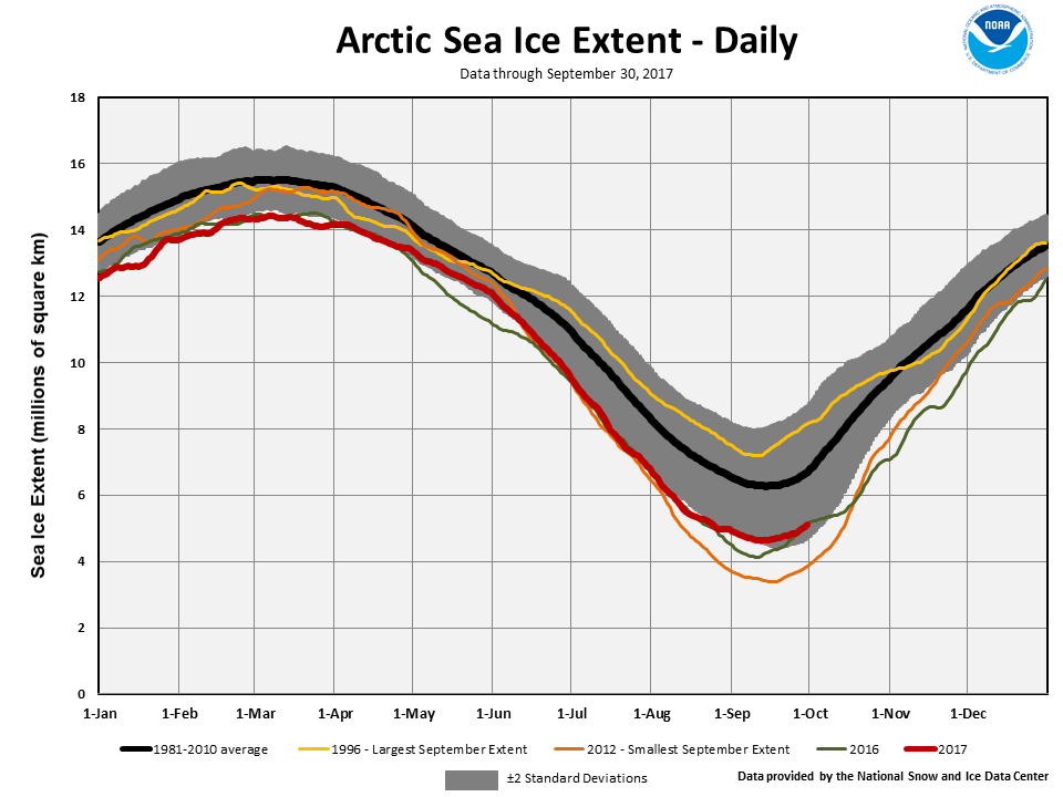
On September 13th, Artic sea ice reached its annual minimum extent, two days earlier than average. The 2017 minimum was 4.64 million square km (1.79 million square miles), 1.22 million square km (471,000 square miles) below the 1981-2010 average, the eighth smallest minimum Arctic sea ice extent since satellite records began in 1979. The 2017 minimum sea ice extent was 1.25 million square km (480,000 square miles) larger than the record smallest annual minimum extent that occurred in 2012. Large areas of open ocean that are typically ice covered in mid-September were observed on the 13th, including large areas of the Beaufort and Chukchi Seas on the Pacific side of the Arctic with the location of the ice edge further north than at any time on record for the region. The Northern Sea Route was mostly ice free, while parts of the Northwest Passage continued have high ice concentration. Ships were able to traverse the southern route of the Northwest Passage with the assistance of ice breakers, but the northern route remained blocked by thick ice.

The September Southern Hemisphere (Antarctic) sea ice extent was 18.03 million square km (6.96 million square miles), which was 850,000 square km (330,000 square miles), or 4.51 percent, below the 1981-2010 average. This was the second smallest September Southern Hemisphere sea ice extent on record and only slightly larger than the September extent in 1986. Southern Hemisphere September sea ice extent is increasing at an average rate of 0.69 percent per decade, with substantial inter-annual variability. It appeared that the Antarctic sea ice extent might have reached its annual maximum extent in mid-September, but a late-season surge in ice expansion caused the maximum to occur in mid-October.
For further information on the Northern and Southern Hemisphere snow and ice conditions, please visit the NSIDC News page.