Contents of this Section:
 January 2011 Selected Climate
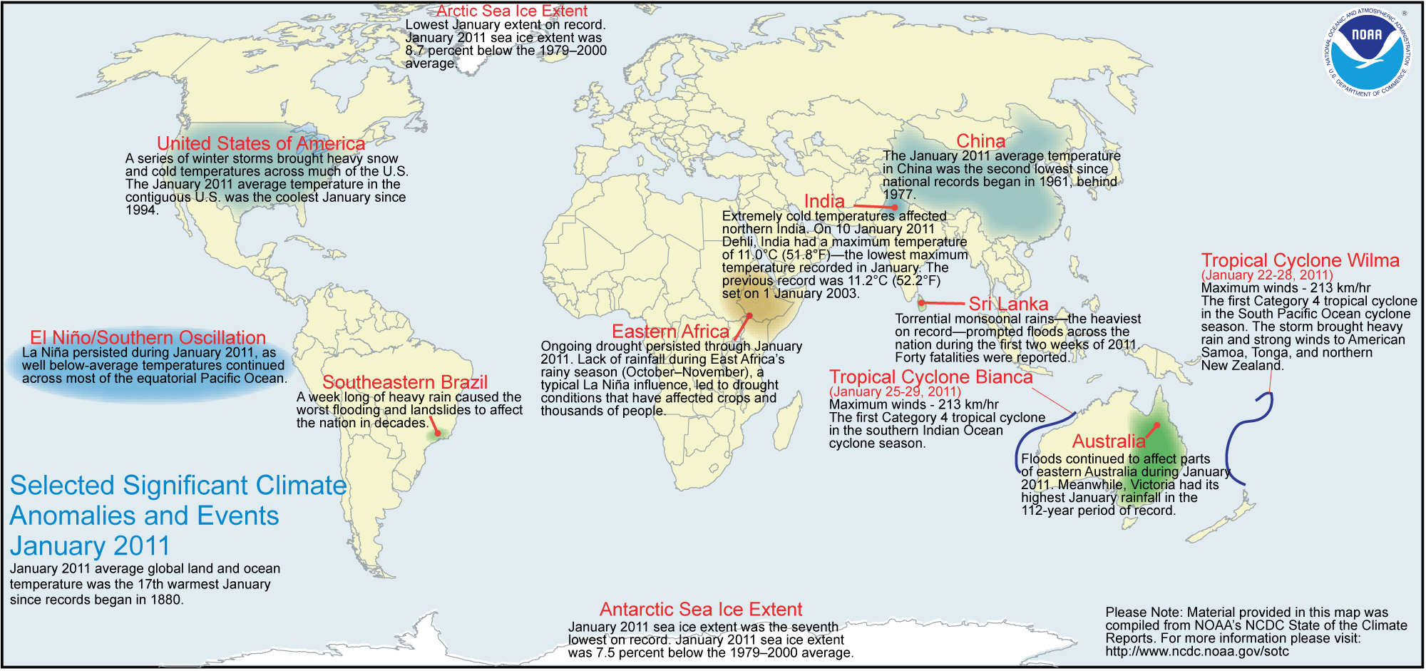
Anomalies and Events Map
Global Highlights
- The combined global land and ocean average surface temperature for January 2011 was 0.38°C (0.68°F) above the 20th century average of 12.0°C (53.6°F). This is the 17th warmest January on record.
- The global land surface temperature for January 2011 was 0.45°C (0.81°F) above the 20th century average of 2.8°C (37.0°F)—tying with 1949 as the 29th warmest January on record. Land surface termperature in the Northern Hemisphere was the 37th warmest on record for January. In the Southern Hemisphere, land surface temperatures ranked as 12th warmest on record.
- The worldwide ocean surface temperature for January 2011 was the 11th warmest January on record, at 0.35°C (0.63°F) above the 20th century average of 15.8°C (60.5°F).
Please Note: The data presented in this report are preliminary. Ranks and anomalies may change as more complete data are received and processed. Effective with the July 2009 State of the Climate Report, NCDC transitioned to the new version (version 3b) of the extended reconstructed sea surface temperature (ERSST) dataset. ERSST.v3b is an improved extended SST reconstruction over version 2. For more information about the differences between ERSST.v3b and ERSST.v2 and to access the most current data, please visit NCDC's Global Surface Temperature Anomalies page.
Introduction
Temperature anomalies for January 2011 are shown on the dot maps below. The dot map on the left provides a spatial representation of anomalies calculated from the Global Historical Climatology Network (GHCN) dataset of land surface stations using a 1961–1990 base period. The dot map on the right is a product of a merged land surface and sea surface temperature (SST) anomaly analysis developed by Smith et al. (2008). For the merged land surface and SST analysis, temperature anomalies with respect to the 1971–2000 average for land and ocean are analyzed separately and then merged to form the global analysis. For more information, please visit NCDC's Global Surface Temperature Anomalies page.


January 2011
The combined global land and ocean surface temperature anomaly for January 2011 was 0.38°C (0.68°F) above the 20th century average, resulting in the 17th warmest January since records began in 1880. Separately, both the Northern Hemisphere and Southern Hemisphere land and ocean temperatures were also 0.38°C (0.68°F) above the 20th century average, resulting in the 21st warmest January for the Northern Hemisphere and the 15th warmest on record for the Southern Hemisphere. Although the temperature anomaly is the same for the Northern and Southern Hemispheres, as well as the globe, each region has a different 20th century average temperature. This results in the same monthly temperature anomaly ranking differently for the different regions. The worldwide monthly averaged land surface temperature tied with 1990 as the 29th warmest January on record, with a temperature anomaly of 0.45°C (0.81°F) above the 20th century average. As shown in the dot maps above, warmer-than-average temperatures during the month of January were present across much of the world's land areas. The warmest anomalies occurred across the eastern half of Canada, Iran, and much of Siberia. Cooler-than-average conditions were present across southern Siberia, Mongolia, and most of China.
According to the Beijing Climate Center, January 2011 ranked as China's second coolest January on record—behind 1977—since national records began in 1961.
The worldwide sea surface temperatures (SST) during January 2011 were warmer than average across most of the oceans, with the exception of cooler-than-average conditions across the central and eastern equatorial Pacific Ocean, part of the southern Atlanitic Ocean, part of the Indian Ocean, and the southern oceans. The global ocean temperature ranked as the 11th warmest January on record, with an anomaly of 0.35°C (0.63°F) above the 20th century average. A moderate-to-strong La Niña remained across the equatorial Pacific Ocean during the month. Of note, the January 2011 global ocean temperature was the warmest on record among all Januaries when La Niña was present. The ten warmest Januaries occurred during either El Niño or ENSO-neutral conditions. According to NOAA's Climate Prediction Center (CPC), ENSO-neutral or La Niña conditions are equally likely by May–June 2011.
The average position of the upper-level ridges of high pressure and troughs of low pressure (depicted by positive and negative 500-millibar height anomalies on the  January 2011 map, respectively) are generally reflected by areas of positive and negative temperature anomalies at the surface, respectively. For other Global products, please see the Climate Monitoring Global Products page.
Temperature Rankings and Graphics
| January | Anomaly | Rank (out of 132 years) | Warmest on Record | ||||
|---|---|---|---|---|---|---|---|
| °C | °F | Year | °C | °F | |||
| Global | |||||||
| Land | +0.45 ± 0.14 | +0.81 ± 0.25 | 29th warmest* | 2007 | +1.75 | +3.15 | |
| Ocean | +0.35 ± 0.07 | +0.63 ± 0.13 | 11th warmest | 1998 | +0.56 | +1.01 | |
| Land and Ocean | +0.38 ± 0.08 | +0.68 ± 0.14 | 17th warmest | 2007 | +0.82 | +1.48 | |
| Northern Hemisphere | |||||||
| Land | +0.43 ± 0.22 | +0.77 ± 0.40 | 37th warmest | 2007 | +2.18 | +3.92 | |
| Ocean | +0.35 ± 0.08 | +0.63 ± 0.14 | 8th warmest | 1998 | +0.55 | +0.99 | |
| Land and Ocean | +0.38 ± 0.12 | +0.68 ± 0.22 | 21st warmest | 2007 | +1.15 | +2.07 | |
| Southern Hemisphere | |||||||
| Land | +0.50 ± 0.06 | +0.90 ± 0.11 | 12th warmest* | 2010 | +0.82 | +1.48 | |
| Ocean | +0.36 ± 0.06 | +0.65 ± 0.11 | 16th warmest* | 1998 | +0.58 | +1.04 | |
| Land and Ocean | +0.38 ± 0.06 | +0.68 ± 0.11 | 15th warmest | 2010* | +0.60 | +1.08 | |
*Signifies a tie
* Global Land tied with 1949 as 29th warmest on record.
* Southern Hemisphere Land tied with 1999 and 2008 as 12th warmest on record.
* Southern Hemisphere Ocean tied with 1980 as 16th warmest on record.


The most current data may be accessed via the Global Surface Temperature Anomalies page.
Precipitation
The maps below represent anomaly values based on the GHCN dataset of land surface stations using a base period of 1961–1990. The areas with the wettest anomalies during January 2011 included large parts of coastal Australia, northeast Brazil, and much of Indonesia. The driest anomalies were observed across a portion of central West Africa, Pakistan, India, much of northeast Asia, French Polynesia, the Hawaiian Islands, and parts of Mexico.


According to the Bureau of Meteorology, flooding in Australia was widespread in southeast Queensland and Victoria. Average monthly rainfall across Victoria was the highest January rainfall in the 112-year period of record.
Additional details on flooding and drought can be found on the January 2011 Global Hazards page.
References
Peterson, T.C. and R.S. Vose, 1997: An Overview of the Global Historical Climatology Network Database. Bull. Amer. Meteorol. Soc., 78, 2837-2849.
Quayle, R.G., T.C. Peterson, A.N. Basist, and C. S. Godfrey, 1999: An operational near-real-time global temperature index. Geophys. Res. Lett., 26, 333-335.
Smith, T.M. and R.W. Reynolds (2005), A global merged land air and sea surface temperature reconstruction based on historical observations (1880-1997), J. Clim., 18, 2021-2036.
Smith et al (2008), Improvements to NOAA's Historical Merged Land-Ocean Surface Temperature Analysis (1880-2006), J. Climate., 21, 2283-2293.