

Across Bosnia and Herzegovina, heat and dry conditions during
the summer months promoted drought across many areas. The
intensification of drought has forced numerous people to travel
many kilometers to find water, as the cost of trucking water into
communities was too expensive for most villages (IFRC).
In the United Kingdom, September was dry and warm. It was the
driest month since 1997, with rainfall 58 percent of average.
Sunshine in September averaged 6.06 hours of bright sunshine per
day, or the most since the England and Wales sunshine measurements
began in 1961. The Central England Temperature for
January-September was 16.26°C (61.3°F), or the
warmest January-September since records began in 1659 (UK Met
Office).

 larger
image
larger
image
|
In India, heavy
rains at the end of August and early September produced
flooding across much of the state of Orissa. Flooding affected over
3,500 villages and resulted in 14 deaths (UNDP). |
| Exceptionally heavy
rains affected the Sahel region of Africa during late August and
into September. Flooding affected parts Burkina Faso, Mali,
Mauritania and Niger, causing at least 15 deaths and destroying
thousands of homes (IFRC). In northern Nigeria, flooding was
characterized as the worst in more than 20 years in Kaduna state.
Thousands of people were forced to flee their homes as the Kaduna
River rose above the flood stage on September 7 (IFRC). |

larger
image
|
 larger
image
larger
image
|
Across China,
landslides and floods in the northwestern province of Shaanxi
killed at least 38 people by early September, and forced a
half-million people from their homes (Reuters). Flooding was
extensive along the Weihe, the largest tributary of the Yellow
River. |
Monsoonal rainfall that began in July in Pakistan resulted in
significant flooding across the country. The rains affected more
than 800,000 people leaving 250 dead, along with significant
property damage (IFRC). The monsoon season in Pakistan typically
runs through mid-September.
 larger
image
larger
image
|
Heavy rains in early
to mid-September across portions
of central Mexico brought flooding to several states. Floods
damaged thousands of homes and displaced thousands of people in the
states of Querétaro, Guanajuato, Nayarit,
Michoacán and Veracruz (IFRC). |
In Honduras, heavy rains during September 14-15 caused flooding
along the Ulúa River, which damaged the country's
agricultural and fishing sectors. The heaviest losses were reported
in the province of Cortés, where plantain, corn and
sugarcane were the crops most seriously affected (IFRC).
For an archive of flood events worldwide, see the
Dartmouth Flood Observatory.

| Severe thunderstorms,
including several confirmed tornadoes, spread across portions of
the U.S. Mid-Atlantic coastal plain during September 22-23, 2003.
Parts of Richmond, Virginia were hit with 160 km/hr (100 mph) wind
gusts as the storms moved through, with 40,000 customers losing
power in the state (Associated Press). More power outages occurred
in New Jersey and Pennsylvania, with an F-1
tornado causing damage in Delaware Township, New Jersey (New
York Times). |

larger
image
|

 Radar Image (Courtesy: NCAR)
|
Hurricane Jimena formed as
a tropical depression on August 28 and reached hurricane strength
by the 29th. Jimena weakened into a tropical storm as it passed
south of the Big Island of Hawaii on September 1st. Maximum
sustained winds on the 1st were 63 km/hr (34 knots or 39 mph) with
gusts to 85 km/hr (46 knots or 53 mph) at South Point. As many as
1,500 people lost electricity on the Big Island and rainfall
amounts ranged from 95 mm (3.74 inches) at the Hilo airport to 163
mm (6.42 inches) at Mountain View (NWS/CPHC). |
| Hurricane Fabian
developed in the eastern Atlantic from a tropical wave on the 27th
of August, several hundred miles west of the Cape Verde Islands.
Fabian became a tropical storm on the 28th and a hurricane on the
29th, and reached 'major hurricane' status (category 3 or higher on
the Saffir-Simpson scale) on the 30th. Fabian reached category 4
strength on the 31st, but did not reach maximum windspeeds of
230km/hr (125 knots or 145 mph) until September 1st. |

larger
image
|
Fabian passed near Bermuda on the 5th with maximum sustained
winds on the island near 185 km/hr (100 knots or 115 mph) with
gusts to 215 km/hr (115 knots or 132 mph). The storm was the
strongest to hit the island since Hurricane Arlene in August 1963.
The storm produced widespread power outages and damaged nearly
one-quarter of the island's hotels and guest houses. The storm was
responsible for 3 deaths in a boating accident east of the Canadian
Maritimes (Reuters).
Tropical Storm Henri developed
in the eastern Gulf of Mexico on the 3rd and weakened into a
tropical depression before crossing Florida on the 6th. The effects
of Henri were minimal, with some localized heavy rain and gusty
winds. Henri dissipated by the 8th.
 larger
image
larger
image
|
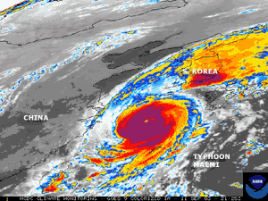
Typhoon Maemi formed as a
tropical depression on the 5th in the open waters of the Philippine
Sea. Maemi reached typhoon status by the 7th, peaking out on the
10th with maximum sustained winds near 280 km/hr (150 knots or 170
mph). Maemi made
landfall across southeastern South Korea on the 12th with
maximum sustained winds near 195 km/hr (105 knots or 120 mph). The
storm triggered landslides and floods that were responsible for at
least 117 deaths, and forced 25,000 to evacuate their homes (OCHA).
Estimated property damage was preliminarily set at $4.1 billion
(USD), with 5,000 homes destroyed and another 13,000 damaged
(OCHA). |
 Click for
Animation
Click for
Animation
|
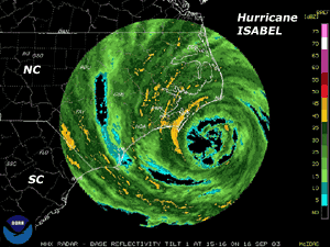
Isabel tracked
northwestward and made landfall along the Outer Banks of North
Carolina as a category-2 hurricane with maximum sustained winds
near 160 km/hr (85 knots or 100 mph). Heavy rain from the hurricane
had spread well inland over much of the Mid-Atlantic region during
the afternoon and evening of the 18th, along with a broad area of
tropical storm to hurricane force wind gusts over eastern North
Carolina, eastern Virginia and northward to the New Jersey
shore. |
| Isabel brought a
storm surge of 6-8 feet (1.8-2.4 meters) to the Outer Banks,
which cut a
new inlet near Cape Hatteras Village. Strong winds well inland
resulted in power outages for 1.8 million Dominion Power customers
in Virginia and North Carolina, the largest outage in the company's
history (Associated Press). Preliminary damage estimates are around
$1 billion, likely adding Isabel to the list of U.S. Billion Dollar Weather
Disasters. There were at least 40 fatalities, with 25 of them
in Virginia (Associated Press). |

larger
image
|
Rainfall totals from Hurricane Isabel are
available, as well as a detailed comparison of
Isabel with past hurricanes, Hugo and Floyd.
 larger
image
larger
image
|
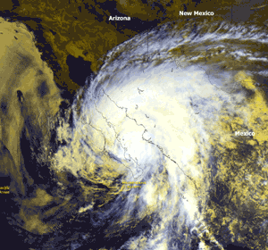
Hurricane Marty developed
as a tropical depression in the eastern Pacific Ocean on the 19th.
Marty made landfall along Mexico's Baja Peninsula on the 22nd near
San Jose del Cabo with maximum sustained winds near 160 km/hr (85
knots or 100 mph). Marty weakened as it tracked northward across
the Gulf of California, spreading heavy rains as far north as
Arizona by the 24th. Marty was responsible for 10 deaths, and was
the second hurricane in less than a month to affect Baja California
(Reuters/AFP). |
| Typhoon Choi-Wan
passed east of Japan on the 21st but fringe effects from the storm
caused gusty winds and locally heavy rainfall for coastal areas of
eastern Japan. |

larger
image
|
 larger
image
larger
image
|
Hurricane Juan developed in
the Atlantic Ocean well southeast of Bermuda as a tropical
depression on the 25th. Juan moved north and made landfall in Nova
Scotia late on the 28th/early on the 29th as a hurricane. Winds in
Halifax gusted to 143 km/hr (77 knots or 89 mph), producing
widespread power outages and wind damage, and resulting in two
deaths (CNN/Associated Press). A state of emergency was declared in
Halifax, and 150,000 people remained without power as of the 30th
(Reuters). |
No reports of significant extratropical cyclones were received
during September 2003

No reports of severe winter weather were received during
September 2003.
References:
Basist, A., N.C. Grody, T.C. Peterson and C.N. Williams, 1998:
Using the Special Sensor Microwave/Imager to Monitor Land Surface
Temperatures, Wetness, and Snow Cover. Journal of Applied
Meteorology, 37, 888-911.
Peterson, Thomas C. and Russell S. Vose, 1997: An overview of
the Global Historical Climatology Network temperature data base.
Bulletin of the American Meteorological Society,
78, 2837-2849.
|
 Hurricane Isabel Hits NC/VA (Click for 2.7MB
Loop)
Hurricane Isabel Hits NC/VA (Click for 2.7MB
Loop)


