Updated 31 Oct 2012

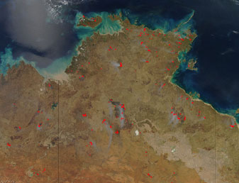
Early spring continued to foster dry conditions in the Southern Hemisphere. Central Australia, which typically receives very little rainfall during its May to September dry season, experienced extreme dryness during the month. On September 29th, a light rain of 3 mm (one-eighth inch) ended a streak of 157 consecutive days without precipitation at Alice Springs Airport. The streak was the longest dry spell at the location since records began in 1940. A fire vortex that spun up to 30 m (100 ft) high erupted during a wildfire near Alice Springs on September 11th.
In eastern Australia, dangerous wildfire conditions existed in New South Wales (NSW) where up to 50 grass, scrub, and bushfires flared in early September. Strong northwest winds fanned a grass fire near Berridale which destroyed a historic homestead and scorched almost 500 acres in the Snowy Mountains. Water-dropping aircraft assisted in containment efforts on another wildfire in the Budderoo National Park. Sydney experienced high temperatures of 31°C (88°F) during late September, where hot and dry conditions in NSW were cited as the worst in nearly 40 years, according to media reports.
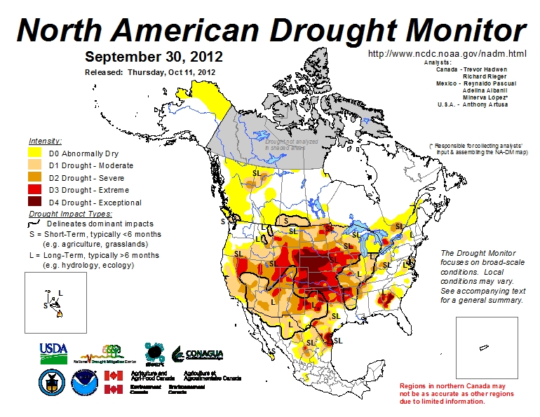
In the Northern Hemisphere, persistent drought and warmth in the U.S. and Canada fueled wildfires through beetle-killed forests. Over 64 percent of the contiguous U.S. was experiencing moderate-to-exceptional drought. Please visit the U.S. Drought Monitor report and NOAA's Wildfires page for additional information. Year-to-date acres burned through September in the U.S. was 8.8 million acres (48,258 fires), and 4.7 million acres in Canada (7,288 fires). In British Columbia, four homes were destroyed by flames and over 1,500 people were evacuated on September 9th, according to media reports. The arid Canadian region of Okanagan that is ideal for the cultivation of vineyards is prone to wildfires in dry seasons. The White Spruce Creek wildfire threatened oil and gas facilities late in the month and prompted local evacuations, while blazing over 54,000 acres to the east of Fort Nelson.
Across Europe, wildfires continued to take a toll as hot temperatures and gusty winds exacerbated the fire behavior. According to media reports, fires in Portugal destroyed over 173,000 acres between January and August and claimed the lives of two firefighters. About 20 bushfires blazed in the drought-stricken country in early September and threatened up to 3,000 people. In western Portugal, one person perished in the flames, which destroyed two homes and a factory, and caused disruption of road and rail services between Pombal and Fatima.
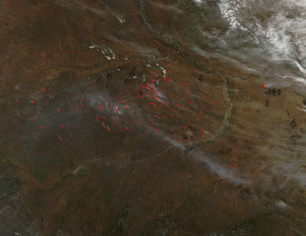
In Spain, more than 378,000 acres burned between January and August 2012, which was triple the amount for the same period in 2011 — and was the highest amount burned in a decade, according to media accounts. In early September, one fatality and five injuries in southern Spain resulted from an intense forest fire in the Costa del Sol region, which charred over 12,000 acres and forced the evacuation of nearly 4,000 people near Ojen. In Russia, over 74 million acres burned between January and August, mostly in the eastern and central Siberian taiga. Scientists determined the Russian wildfires emitted more carbon monoxide in 2012 (48 teragrams) than in any year since 2003 (72 teragrams).

Heavy rainfall in west and central Africa resulted in widespread flooding that impacted more than 3 million people since early July. Heavy rains in late August damaged more than 11,400 homes in Senegal and displaced nearly 287,000 of its residents.
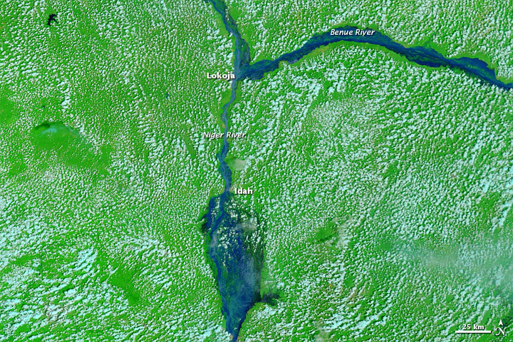
Torrential rains produced deadly flooding in Nigeria and necessitated the release of water from the Jebba and Kainji hydropower dams on the Niger River in late September to prevent their collapse. Emergency officials estimated over 35,000 people in central Nigeria were displaced from their homes during the month, with many villagers being rescued by boat from rooftops or trees. Flooding in the Kogi state, which occurred at the confluence of the Niger and Benue rivers, was deemed as the worst in 50 years. Flood waters carried hippopotamuses, crocodiles, and snakes into residential areas. Humanitarian relief organizations sought to provide food and shelter for the country's large number of Internally Displaced Persons (IDPs) in the Rivers State, whose plights were compounded by the deluges. Flooding threatened the cocoa-producing farmlands in the southwestern region of Nigeria, where 2 m (7 ft) of water submerged roads leading to the commercial center near Lagos. According to media accounts, at least 148 deaths resulted from flooding within the north and central Nigerian states since early July, while the heavy rains displaced over 620,000 Nigerians, close to 4,000 homes, inundated more than 370,000 acres of farmland, and induced at least 135 cases of cholera. As of mid-October, the number of fatalities across the country exceeded 430 since July, with nearly 550,000 homes lost, and more than 1.3 million Nigerians displaced due to the floods.
In the Republic of Niger, floods resulted in 88 deaths, the loss of over 24,000 homes, and affected over 511,000 people during September. Morocco provided nearly 45 metric tons in foodstuff, as part of its humanitarian aid to Niger in early October. In Chad, flooding destroyed over 94,000 homes in September, while 630,000 acres of cropland and nearly 520,000 people were adversely impacted. Heavy rains in mid-September caused breaching of the Lagdo Dam and swelled the Benue River in northern Cameroon, which resulted in up to 40 deaths, nearly 3,000 injuries, and impacted more than 26,000 residents, according to media reports. Morroco provided humanitarian aid to Cameroon during September.
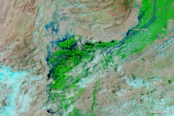
Monsoon rains triggered flash floods and hill torrents across central Pakistan in early September, resulting in widespread loss of life, livelihoods, and infrastructure. Over 4.8 million people were affected, primarily within the Balochistan, Punjab, and Sindh provinces. Extensive humanitarian efforts to provide food rations and medicines were coordinated by World Health Organization partners. Critical dietary staples included fortified wheat flour and vegetable oil, iodized salt, high-energy biscuits and supplements for infants. Standing water and damages to roadways hampered relief activities, which forced the distribution efforts to be conducted by boats. Supplying nutritional safe drinking water and sanitation services were priority needs in the flood-afflicted areas. Nearly 350,000 people sought refuge in over 500 relief camps. More than 402,000 homes and 1.1 million acres of crops were damaged, while over 9,600 cattle perished.
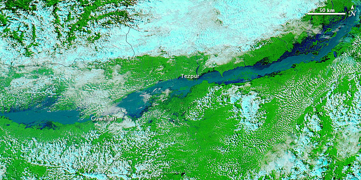
Heavy rains resulted in the flooding of the Brahmaputra River in northeast India during September. The number of displaced people neared 1.8 million, according to media reports. Twenty-one bodies were recovered in the state of Sikkim. At least 13 fatalities occurred in the state of Assam where flooding struck for the third time in 2012. Helicopters dropped provisions of rice, water, biscuits, and baby food to marooned flood victims, as many sought shelter within the estimated 3,000 temporary relief camps. Flooding inundated the 106-acre Kaziranga National Park, which is deemed as a United Nations Educational, Scientific, and Cultural Organization (UNESCO) World Heritage site. The Park is a sanctuary for the world's largest population of one-horned rhinoceroses as well as for numerous tigers, elephants, panthers, bears, and birds.
Flooding along the eastern Canadian coast at mid-month caused damage to homes and roads, according to media accounts. Heavy precipitation of up to 75 mm (2.95 inches) fell in central Nova Scotia on September 10, leaving some homes submerged in close to 1.5 m (4.9 ft) of water. Washed out roadways stranded at least 135 residents near Shubenacadie while some Truro residents were rescued by canoe.

A cold front passage across southern Australia in early September produced blustery winds with gusts up to 100 kph (62 mph) in eastern New South Wales, Tasmania, and Victoria and blizzard conditions in the Alpine areas. Damage occurred to roofs as the winds downed trees and power lines, resulting in over 600 emergency calls for assistance by residents.
Nine fatalities resulted in the wake of strong winds of up to 140 kph (87 mph) and heavy rains across central South America on September 19th, according to media reports. In Paraguay, five people died and over 80 others were injured in storm-related incidents, while at least 5,000 homes were destroyed. In Bolivia, two deaths occurred during flooding in the Santa Cruz region. In Uruguay, flooding claimed two lives and forced over 500 residents to evacuate their homes, and over 300 fallen trees led to power outages for 140,000 homes. The ferry service between Uruguay and Argentina was disrupted. Strong winds and rain in Buenos Aires caused evacuation of at least 25 people, power outages, and numerous traffic accidents. Earlier in the month, heavy rains in Buenos Aires produced extensive flooding which ruined over 8.6 million acres of barley and wheat crops, and losses of newborn calves through drowning.
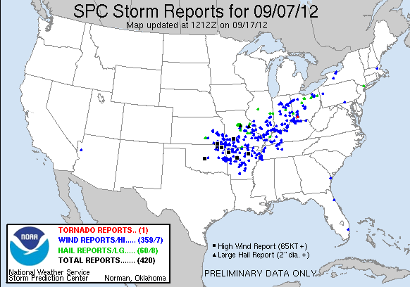
In the U.S., a cold front passage through the Mid-Mississippi Valley to the East Coast resulted in over 900 severe weather reports during September 6th–8th, primarily for wind events. Powerful thunderstorms with hail and gusty winds rolled through central Iowa on September 6th. Four fatalities occurred in Oklahoma as a result of the storms on September 7th. Across Missouri, power poles snapped during strong winds with hail leaving residents without utilities, according to media accounts. Strong winds peaking near 128 kph (80 mph) destroyed three airplane hangars and damaged three airplanes at an Arkansas airport, while falling trees damaged two homes and three cars and up to 71,000 Arkansans lost power. A tornado, which briefly hit in southwestern Ohio, damaged several homes and a barn. In New York, two tornadoes touched down on Long Island on September 8th causing minor structural damage to homes and buildings in Queens, while overturning cars in Brooklyn. Damages from winds occurred along nearly 450 km (300 mi) between Maryland and Connecticut. In Virginia, power outages affected nearly 65,000 residents. Twelve injuries occurred during an evacuation of the Prince George's County Fair in Maryland. Later in the month, two tornadoes struck in eastern North Carolina on September 18th where heavy rain flooded roads and downed power lines. Severe storms in southwestern Illinois on September 25th produced hail stones exceeding 5 cm (2 inches) in diameter and dumped as much as 152 mm (6 inches) of rainfall which resulted in flash floods. At least six tornadoes were reported in the state.
Torrential rains in southern Spain on September 28th resulted in flash flooding, which claimed at least 10 lives and forced evacuation of 600 residents, according to media reports. Thirty-five fairground workers in the town of Gandia sustained injuries when a tornado toppled a ferris wheel during violent thunderstorms. Up to 245 mm (9.6 inches) of precipitation inundated the Murcia region, particularly the provinces of Mãlage and Almeria, where the rains washed out bridges and roads, overturned cars, and disrupted rail services. Farmland was damaged and numerous livestock (pigs, horses, donkeys, and hens) perished.

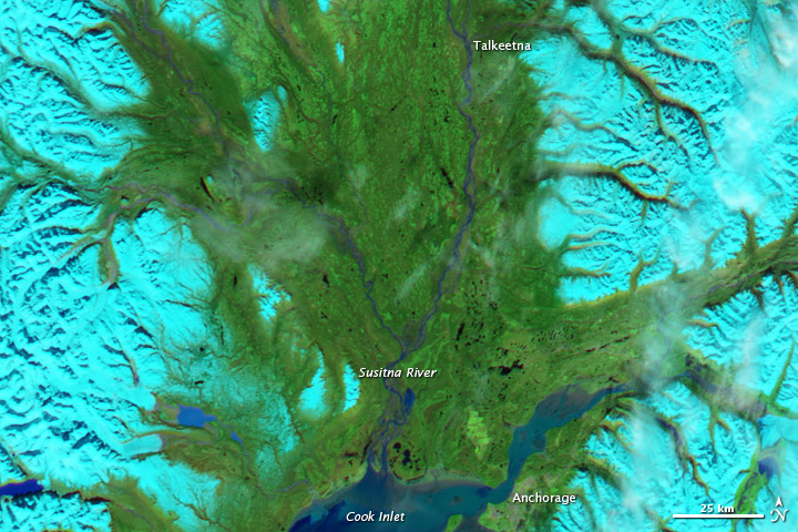
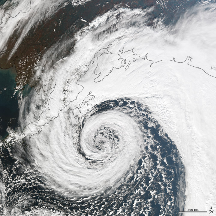
In southern Alaska, heavy rains in excess of 76 mm (3 inches) in the Susitna Valley and Talkeetna Mountains resulted in flooding of small rivers and creeks on September 16th. More rains and strong winds on September 19th produced severe flooding and power outages for 2,500 residents in the Matanuska-Susitna Borough. A levee along the Montana Creek was breached and reinforced with truckloads of rock. Residents of the Willow Creek area were evacuated. At least 10 persons were rescued from a flash flood near Wasilla where water levels approached nearly 1.8 m (6 ft). A 152-meter (500-foot) section of the Alaska Railroad along Gold Creek was washed out and prevented freight service by trains to Fairbanks. The Town of Talkeetna was evacuated on September 21st, as the Talkeetna River crested at 5.2 m (16.9 ft), which was second to its record high level of 5.3 m (17.4 ft), according to media reports. Nearby the Susitna River flooded. At least 60 roads and 820 residences were damaged of which 14 homes were destroyed. Flood waters began to slowly recede by the morning of September 22nd.
One fatality was presumed as a man was swept into Butte Creek while attempting to cross on September 24th, where flooding on the Denali Highway stranded a group of nearly 70 hunters. Within days another powerful extratropical cyclone developed off the Alaskan coast, but positioned to lessen the effects of its strong winds and rain over the south-central region. Following a rapid intensification, the storm's central pressure dropped to a minimum of near 956 mb. Coastal areas near Seward received up to 152 mm (6 inches) in additional precipitation, according to media reports. In Valdez, rain fell on 27 of 30 days during September for a total of 664.5 mm (26.16 inches), which was not only the highest amount for September, but also for any month at the location in records since 1949. The previous wettest month was November 1976 when 522.9 mm (20.59 inches) was recorded. The previous September record of 423.9 mm (16.69 inches) was set in 1981.

Two tropical cyclones developed off Africa's west coast during September, each reached hurricane strength. Hurricane Michael (Sep 3th–11th), which was the first Atlantic Basin storm to attain Category 3 strength in 2012, stayed entirely over ocean, as did the meandering Hurricane Nadine (Sep 11th–Oct 4th). Nadine earned the distinction as the second-longest Atlantic Tropical Storm on record with 21.25 days (ties Ginger of 1971). Please visit NOAA's Hurricanes and Tropical Storms page for detailed information.
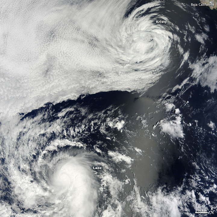
In the Eastern Pacific, two hurricanes and three tropical storms originated during the month. Tropical Storms John (Sep 2nd–4th), Kristy (Sep 9th–17th), and Hurricane Miriam (Sep 22nd–28th) followed similar tracks along the west coast of Mexico. Likewise, Hurricane Lane (Sep 15th–19th) remained completely at sea. Tropical Storm Norman (Sep 28th–30th) made landfall near Topolobampo, Mexico, and claimed one fatality. A shrimp trawler ran aground at the port of Mazatlãn and one of the eight crewmen was injured, according to media accounts. About 400 vessels sought safety from Norman's strong winds and large waves within the harbors along the Sea of Cortez. The southwestern U.S. also received heavy rainfall associated with Norman in excess of 102 mm (4 inches).
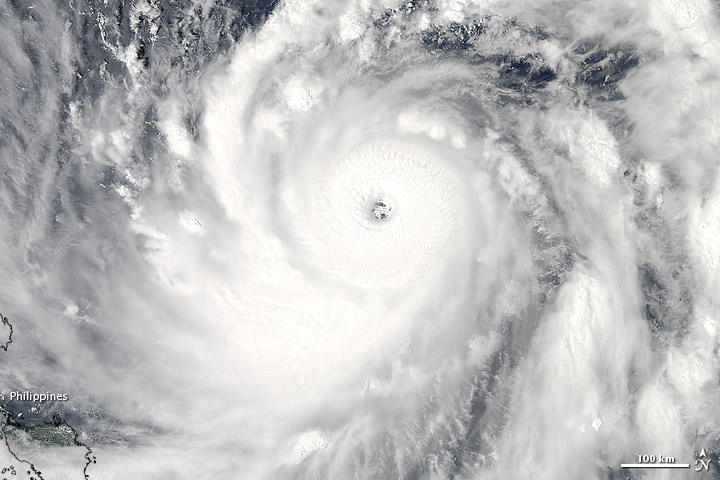
Six tropical cyclones formed in the Western Pacific during September of which two storms developed into deadly typhoons. Typhoon Sanba (a.k.a. Karen; Sep 9th–18th), which originated west of the Philippines, reached Category 5 strength by September 13th before making an initial landfall on September 16th in Okinawa, Japan, then another landfall in South Korea on September 17th. Sanba became the fourth typhoon to strike the Korean Peninsula in a single year — an event that has not occurred for 50 years, according to media reports. Over 200 mm (7.8 inches) of precipitation fell in southern regions of the country prompting landslides in the Gyeongsang province. Six fatalities resulted, more than 1,100 Korean residents were forced to evacuate, while over 67,000 Japanese and 382,000 Korean households lost power due to the storm. Extensive flooding occurred in the Philippines, western Japan, northeastern China, and Far East Russia in association with the storm's passage. The Russian city of Vladivostok received up to 107 mm (4.2 inches) of precipitation in 24 hours, which flooded roads and parts of the local airport.
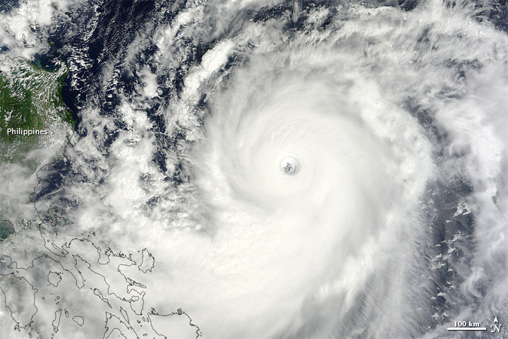
Typhoon Jelawat (a.k.a. Lawin; Sep 20th–Oct 1st), which originated east of Guam and veered northeast of Taiwan to make two landfalls in Japan, resulted in seven deaths and at least 180 injuries, according to media reports. The powerful storm was the second to hit the region in two weeks and the 17th typhoon to strike Japan in 2012. Heavy rains and strong winds resulted in widespread power outages and disrupted transportation services. Jelawat punched Okinawa with nearly 185 kph (115 mph) winds on September 29th, accompanied by gusts to nearly 232 kph (144 mph) which exerted force to overturn vehicles. Jelawat arrived west of Tokyo with winds of 126 kph (78 mph) on September 30th. Precautionary evacuations of over 50,000 residents along rivers were mandated in the city of Nagoya.
After their respective originations near Guam, Tropical Storms Ewiniar (Sep 23rd–30th) and Maliksi (Sep 29th–Oct 4th) followed similar northward tracks to the east of Japan, bringing heavy rains and storm surges along Honshu. Tropical Storm Gaemi (a.k.a. Marce; Sep 29th–Oct 7th ) formed in the South China Sea and initially moved toward the Philippines before looping back to make landfall in central Vietnam. One fatality resulted when the storm's strong winds and waves capsized a motor bancas transporting three Filipino fishermen. Flooding from storm surge in the Philippines resulted in emergency assistance to nearly 300 residents and damage to over 50 homes. The storm brought heavy rains and flooding to parts of Vietnam, Laos, Cambodia, and Thailand. The strong winds of the storm posed a threat to Vietnam's coffee industry whose harvest was near, as the young cherries, which contain the coffee plant's beans, could be dropped prematurely. Reservoirs in Thailand were lowered in advance of the torrential rains as a safety measure.

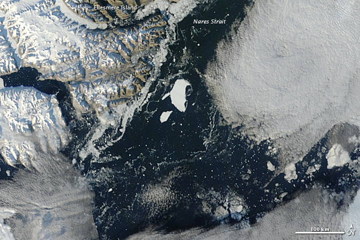
During September, the Arctic sea ice retreated to an all-time minimum extent since satellite records began in 1979, with an average extent of 1.39 million square miles. On September 16th, the lowest daily extent was 1.32 million square miles. The amount of melt during the season was 4.57 million square miles, which would be about the size of the entire U.S. and Mexico combined. The Arctic region is the fastest-warming region on the planet and its September sea ice extent has declined by 13 percent per decade over the last 33 years. Scientists concluded that the shrinking Arctic ice may have contributed to extreme effects on weather in Greenland, the U.S., and western Europe. For a more thorough discussion of sea ice extent, please see NOAA's Press Release. Reduction in Arctic ice threatens the habitats of Arctic wildlife including polar bears and walruses. Initial oil drilling operations were hindered by an enormous chunk of sea ice adrift in the Chukchi Sea. The ice — spanning 360 square miles across and up to 25 m (82 ft) in thickness — forced relocation of the Royal Dutch Shell drillship on September 10th.
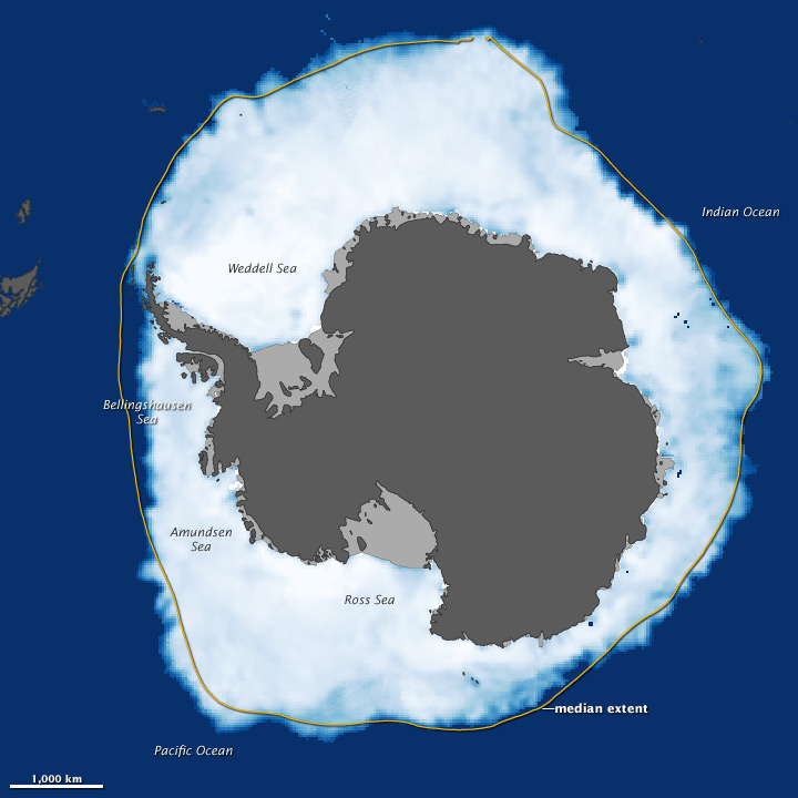
Conversely, at the opposite pole, Antarctic sea ice reached its all-time highest daily extent on record with a maximum extent of 7.51 million square miles on September 26th, while the month's average Antarctic sea ice extent was 7.49 million square miles. September sea ice has grown by about 1 percent per decade in Antarctica. Albeit counterintuitive, the Antarctic is undergoing a warming, as much as 3°C (5°F) annually and by 5°C (9°F) in winter over the past 60 years along the Antarctic Peninsula. A recent study published in Polar Biology concluded that declines in two penguin species (the Adelie and Chinstrap) in western Antarctica were linked to the warming effect. The penguins failed to attain the better nesting spaces and lost access to food sources. Yet, a third penguin species (Gentoo) has adapted and its number increased. Another study addressed the future climate impacts from the potential release of methane gas as Antarctic glaciers melt. During September, researchers on a voyage to East Antarctica produced a three-dimensional (3-D) map of the underside of sea ice for the first time by using an Autonomous Underwater Vehicle (AUV). The AUV technology outfitted with multi-beam sonar was deemed a significant advance for measuring the thickness and volume of sea ice. Mapping obtained by the free-swimming robotic submarine will be combined with aerial measurements of surface snow and ice features to create a comprehensive 3-D map.

Desert locust swarms were present in northern Africa during September following a second generation breeding, where heavy rains resulted in favorable ecological conditions. Treatment for locusts was applied to over 1,500 acres in Chad, and about 100 acres in Sudan as part of sustainable disaster risk reduction efforts. Locusts also bred along the Indo-Pakistan border while vegetation was green. The U.S. Agency for International Development (USAID) provides disaster assistance in countries like Africa that are subject to emergency transboundary outbreak pests (ETOPs), which include locusts, grasshoppers, armyworm, and rodents. Active monitoring of ETOPs is conducted to minimize the threat they pose on food security and economic well-being of affected communities.
 NOAA's National Centers for Environmental Information
