Northeast Region:
(Information provided by the Northeast
Regional Climate Center)
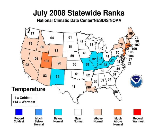
- The Northeast's average July temperature of 70.7°F
(21.5°C) was 0.9°F (0.5°C) above normal. This was
2.5°F (1.4°C) warmer than July 2007 and 1.3°F
(0.7°C) cooler than July 2006. Of the twelve states in the
region, only Maryland and West Virginia had averages below normal.
Maryland temperatures were 0.4°F (0.2°C) below normal and
West Virginia's were 1.0°F (0.6°C) below normal. The
remaining states saw temperatures that ranged from 0.6°F
(0.3°C) above normal in Vermont to 3.1°F (1.7°C)
above normal in Rhode Island. It was the 6th warmest
July since 1895 in Rhode Island.
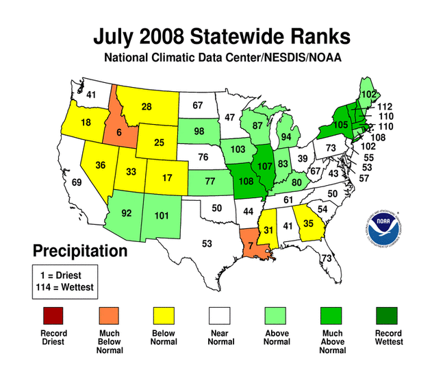
- Rainfall was abundant in the northern part of the region and
near or below normal in the southern half of the region. On
average, the Northeast saw 5.2 inches (132 mm) of rain, which was
127% of its normal July total. Of the three states with below
normal rainfall, New Jersey and Delaware were the driest, each with
95% of the normal July rainfall. Maryland tallied 98% of normal
rainfall. Elsewhere, precipitation totals ranged from 105% of
normal in Pennsylvania to 182% of normal in Rhode Island. With a
state average of 7.46 inches (190 mm), Vermont had its
3rd wettest July in 114 years. It was the 5th
wettest July in Massachusetts and New Hampshire, the 7th
wettest in Rhode Island and the 10th wettest in New
York.
- Severe weather on July 24th spawned a tornado in New
Hampshire that killed one woman near Deerfield and injured several
others. At its strongest, the tornado was categorized as an EF2 on
the enhanced
Fujita scale, which is characterized by winds from 111 to 135
mph (179 to 217 km/hr). Thousands of trees were downed and about a
dozen homes destroyed along its 40-mile path from Deerfield to
Freedom. New Hampshire averages about two tornadoes per year, and
this is the first confirmed tornado in New Hampshire for 2008. More
information can be found at the
Gray/Portland NWS Forecast Office.
For more information, please go to the Northeast
Regional Climate Center Home Page.
Midwest Region:
(Information provided by the Midwest
Regional Climate Center)
- Temperatures across the Midwest were cooler than normal in most
areas. The exceptions were in northeastern Wisconsin and
northwestern Minnesota, where temperatures averaged 1°F
(0.6°C) above normal, and in eastern and northeastern Ohio,
where temperatures were 1-2°F (0.6-1.2°C) above normal.
The coolest weather was found across the central Midwest, where
clouds and thunderstorms were most prevalent. July temperatures in
southeastern Iowa, western Illinois, and northeastern Missouri were
1.5-2.5°F (0.8-1.4°C) below normal. High temperatures
equal to or greater than 90°F (32°C) were limited to
southern and western Missouri, southern Illinois, and Kentucky. As
of July 31, many locations in the central and northern Midwest had
yet to record the first 90°F (32°C) temperature of the
season.
- Much of the central Midwest received normal to above normal
rainfall during July, but an area from central Iowa through the
northeastern half of Missouri into western Illinois accumulated
more than twice the normal July rainfall. A small area in northern
Missouri received more than three times the normal monthly
rainfall. Clusters of thunderstorms repeatedly developed and moved
over this area during the month. Rainfall amounts in northern
Missouri approached 20 inches (508 mm) for the month. The Long
Branch Reservoir cooperative station in Macon County, MO reported
18.6 inches (473 mm) during July, and there were many locations
reporting more than 15 inches (381 mm) of rain during the month.
Two observers with the Community Collaborative Rain, Hail and Snow
network (CoCoRaHS) in
northern Missouri reported more than 19 inches (483 mm) of rain in
July. The CoCoRaHS observer in Kirksville received more the 19.8
inches (502 mm) of rain, noting that the rain gauge overflowed
during a heavy event on July 25 and some of the rain that fell was
not measured and accounted for in the reported monthly total. In
Macon, Missouri, a CoCoRaHS observer measured 19.6 inches (499 mm)
of rain during the month. Based on preliminary data, July 2008 was
the 7th wettest on record for Missouri, 8th
wettest for Illinois, and the 14th wettest on record for
the nine-state Midwest region. In addition, total January-July
precipitation for Missouri, Illinois, and for the Midwest as whole
was the highest on record.
- The heavy rain in Missouri and Iowa caused widespread flash
flooding. Northern Missouri was particularly hard hit during July,
with three major heavy rain storms occurring in the last week, the
last being associated with the remnants of Hurricane Dolly. Mark
Twain Lake in northeastern Missouri, a flood control reservoir and
major recreational destination, reached a record level of 640.4
feet (195.2 m) on July 30, swelling it to twice its normal size.
The previous record was 636.8 feet (194.1 m) in 1993. Large
releases of water by U.S. Army Corps of Engineers through the
Clarence Cannon Dam caused flooding downstream on the Salt River
and its tributaries. On July 30, the Army Corps of Engineers closed
the lake to all boating traffic and increased the water released
through the dam to 50,000 cubic feet per second (cfs). Releases
above 12,000 cfs are unprecedented. These events negatively
affected area businesses during what is normally the height of the
tourist season.
For details on the weather and climate events of the Midwest during
July, see the weekly summaries in the
MRCC Midwest Climate Watch page.
Southeast Region:
(Information provided by the Southeast Regional
Climate Center)
- Average temperatures for July 2008 were close to normal over
the vast majority of the Southeast. A cool spell during the first
several days of July provided roughly half of the 105 new record
lows for the month. Augusta, GA recorded a low of 54°F
(12°C) during this cool spell, which broke the record for the
lowest minimum temperature for the month of July. The highest
temperatures during July occurred between the 19th and
24th as a Bermuda High extended inland across the U.S.
In fact, nearly 90% of the 63 record highs for the region in July
occurred during this period. The most notable extremes were
registered on July 22 when Hamilton, AL recorded a high of
104°F (40°C) and Hawkinsville, GA and Camden SC each
recorded a high of 103°F (39°C). Temperatures across
Puerto Rico and the Virgin Islands were relatively close to
normal.
- Thunderstorm activity during July produced a large amount of
variability in the monthly precipitation totals on the local to
regional scale. Many of the thunderstorms in the northern portions
of the region were connected with the movement of several cold
fronts across the region. Additionally, the outer rain bands of
developing Tropical Storm Cristobal brushed the coastal Carolinas
from July 17—20. Monthly precipitation totals exceeded 150%
of normal across east-central North Carolina and much of eastern
Florida. Localized regions of excessive precipitation were found
across small portions of the remainder of the region. Palm Bay, FL
and Blewett Lake, NC recorded 19.2 inches (487 mm) and 14.3 inches
(362 mm) of precipitation, respectively, during July. In contrast,
relatively dry conditions continued across much of the remainder of
the Southeast. Monthly precipitation totals of less than 70% of
normal were observed over broad portions of Alabama, Georgia, and
South Carolina as well as eastern and southern portions of
Virginia. San Juan, PR recorded only 1.8 inches (44 mm) of
precipitation during July, which was nearly 2.5 inches (64 mm)
below normal. Several isolated stations received much below normal
precipitation including Huddleston, VA with 0.5 inches (13 mm),
Sand Mountain, AL, with 0.7 inches (17 mm) and Pisgah Forest, NC
with 0.8 inches (21 mm).
- Drought conditions across the region changed very little during
the month. Exceptional drought conditions continued to plague
northwestern South Carolina and portions of western North Carolina
and extreme northeastern Georgia. A broad area of severe to extreme
drought continued to affect much of eastern Alabama, Georgia, South
Carolina, North Carolina, and southwestern Virginia. There were
many reports of severe weather across the Southeast, especially
high winds, which are quite common during the month of July. July
22 was most active day of the month with numerous reports of severe
weather in North Carolina, southwestern Virginia, and portions of
Georgia and Alabama.
For more information, please go to the Southeast Regional
Climate Center Home Page.
High Plains Region:
(Information provided by the High Plains
Regional Climate Center)
- After a below normal spring and early summer, temperatures
throughout the region returned to near-normal values during July.
Most areas had average temperatures within 2°F (1.1°C) of
their July normals. The exceptions within the region occurred in
northeastern Colorado, southwestern Wyoming, and the Nebraska
panhandle, where average temperatures ranged between 3-5°F
(1.7-2.8°C) above normal throughout the month. Areas of well
below normal average temperatures occurred in eastern North Dakota
and small portions of northeastern Kansas, where average
temperatures ranged 2-3°F (1.1-1.7°C) below normal.
Regional high and low temperature extremes both occurred in
Colorado, where Greely experienced the highest temperature in the
region of 110°F (43.3°C) on July 11th. The temperature
set a record high for the day and ranked as the all-time
2nd highest July temperature at the station. On the
other end of the spectrum, Fraser, CO had the lowest minimum
temperature for the High Plains Region at 30°F (-1.1°C)
on July 9th. This temperature ranked as the
3rd lowest minimum on record for the 9th and
the 13th lowest minimum for the month of July for Fraser, CO.
- The intermittent and convective nature of most July
precipitation across the High Plains Region resulted in scattered
areas of above average precipitation and widespread areas of well
below average precipitation. Above average locations included the
Nebraska panhandle, portions of eastern Wyoming, north-central
South Dakota, eastern North Dakota, portions of southeastern
Nebraska, and north-central Kansas. Those areas received between
150%-200% of their normal precipitation amounts for the month of
July. The remainder of the High Plains Region experienced
predominantly below average precipitation (approx 60%) in July,
with the least amounts in southwestern Wyoming and the majority of
Colorado (less than 50%). Roscoe, SD received a total of 6.0 in
(152 mm) throughout the month, resulting in 214% of the average
July precipitation. On the other end of both the spectrum and
region were Boulder and Northglen, Colorado. Boulder received only
0.1 in (2 mm) during the month, which is only 5% of the monthly
average. Even worse was Northglen, where no measurable
precipitation fell during July, which is 1.7 inches (43 mm) below
average.
- The majority of the spring and summer leading up to July have
been well below average in temperature and above average in
precipitation. The above average precipitation has left many
low-lying crop fields unplanted or in very poor shape. Areas around
the Valley, Nebraska NWS office have gone unplanted due to rain
events occurring on an abnormally regular basis throughout the
spring and early summer months. Additionally, areas of Iowa that
were devastated by floods from regular heavy rains over the last
few months have flooded many fields, ruining numerous crops for the
season. In contrast is the rapid expansion and intensification of
drought conditions in North Dakota. Large areas of western and
central North Dakota went from D0 and D1 drought conditions to D3
in approximately one month. Currently, the entire state is in
drought ranging from D0 in the eastern portions to D3 in western
North Dakota.
For more information, please go to the High Plains
Regional Climate Center Home Page.
Southern Region:
(Information provided by the Southern
Regional Climate Center)
- In the month of July, average temperatures in the Southern
Region were generally within a few degrees of normal. In
northeastern Texas, the average July temperature exceeded
3-4°F (1.5-2°C) above normal in a small area near Dallas
and a second small region just north of College Station. In
southern Texas, where drought conditions have recently dominated
the area, temperature averages ranged from 2°F (1°C)
below normal near Brownsville to as much as 4°F (2°C)
below normal just northeast of Carrizo Springs.
- Precipitation during July was quite variable over the Southern
Region, due in part to Hurricane Dolly. The storm slammed into the
southern Texas coast as a category two hurricane on July
23rd. Consequently, monthly rainfall totals in far
southern Texas were excessive, with many stations in the
southernmost counties reporting anywhere from 200 to 600 percent of
normal. Rainfall totals for the month were highest in the Southern
and Lower Valley climate divisions, with values ranging from 3 to 6
inches (76 mm to 152 mm) at most stations to as much as 15.4 inches
(390 mm) at Harlingen. As Dolly pushed inward, she was also
partially responsible for above normal monthly totals in the Trans
Pecos climate division. There, rainfall totals were approximately 3
to 5 inches (76 mm to 127 mm) above average. Unrelated to Dolly,
similar positive departures in rainfall were also observed in the
northern Texas Panhandle and in northern Arkansas. Elsewhere,
rainfall was generally below normal, particularly in southern
Arkansas, eastern Texas and most of Louisiana, where totals ranged
from 5-50% of normal. In parts of Mississippi, western Tennessee,
and southern Oklahoma, precipitation for the month varied between
one quarter and one half of the monthly average.
- The most significant July severe weather in the Southern Region
came in the form of Hurricane Dolly. Shortly before landfall on the
morning of July 23rd, Dolly's maximum wind speeds
increased to approximately 100 mph (160 km/h), making her a
category two storm. Dolly made landfall that afternoon along the
southern Texas coast near South Padre Island. The storm pushed
inland in a northwesterly direction and was quickly downgraded to a
category one storm and, later, a tropical storm. In total, two
deaths were attributed to the hurricane—one by electrocution
and the other by drowning in the surf. Dolly damaged thousands of
Rio Grande homes, tore down power lines, and filled the streets
with flood waters. Over 200,000 people were left without power, the
restoration of which was hindered by flooding. The Federal
Emergency Management Agency (FEMA) announced that federal disaster
aid has been made available for Texas to assist in damage
recovery.
For more information, please go to the Southern
Regional Climate Center Home Page.
Western Region:
(Information provided by the Western
Regional Climate Center)
- Temperatures throughout the West were slightly to moderately
above normal with the exception of the coastal Pacific Northwest
and much of New Mexico. Portions of the Intermountain West had an
extremely warm month, with Denver recording its 2nd
warmest July in the 60 year record. The final 19 days of the month
in Denver equaled or exceeded 90°F (32°C), which broke
its all time consecutive 90°F (32°C) day record. This
record string of hot weather has continued into August. Cheyenne,
WY, recorded just one day below normal during July. In contrast,
most of Alaska had a very cool month, with Anchorage recording its
lowest July average maximum temperature on record while Juneau
observed its 2nd coolest July in recorded history.
- Precipitation was predictably a mixed bag for a summer month,
with the notable exception of very wet conditions in New Mexico due
to strong monsoonal flow and the remnants of Hurricane Dolly.
Cloudcroft, NM recorded its wettest July on record with 13.3 inches
(339 mm) of rain and Albuquerque recorded its 4th
wettest July in 93 years with 3.4 inches (86 mm). Parts of Alaska
were quite wet with Fairbanks measuring its 6th wettest
July on record and Juneau its 2nd wettest.
- On July 9th, 110°F (43°C) heat near
Shafter, California led to the death of a 42 year old vineyard
worker. On July 12th, an intense thunderstorm just north of Mt.
Whitney in California dropped 6-7 inches (153-178 mm) of heavy
rainfall, causing a flash flood and a 300-yard wide mud flow that
seriously damaged 25 homes near Oak Creek and closed U.S. Highway
395 for two days. On July 25th, an 8-year old child was
killed by lightning while watching a baseball game in Tucson, AZ.
Up to 8 inches (203 mm) of rain from the remnants of Hurricane
Dolly fell in a 36-hour period in parts of the Sacramento Mountains
in southern New Mexico, causing numerous flash floods on July
26—27. In Ruidoso, over 100 homes were damaged and 150 people
took refuge in shelters. Eight bridges were damaged or washed out
and numerous highways in the area were closed.
For more information, please go to the Western
Regional Climate Center Home Page.
Alaska: (Information provided by Audrey
Rubel at NOAA NWS Alaska Region Headquarters.)
- Much of Alaska experienced a cooler than average July this
year, despite a warm spell during the beginning of the month across
much of the state. The interior experienced warm summer weather
during the first ten days of the month, but cool and wet conditions
prevailed thereafter. The average July temperature in Fairbanks of
60.6°F (15.9°C) was 1.8°F (1°C) below normal.
July was cooler and wetter than normal across the entire panhandle
as well. High temperatures there were lower than average, with July
2008 having the fewest number of days above 60°F (16°C)
since the early 1970s. In the far north, Kotzebue set two new
record high temperatures during the first week of July and then set
a new record low temperature on July 22 after cooler weather moved
into the area. Despite warm weather in the first part of the month,
July in Nome was 3.1°F (1.7°C) cooler than average.
- Rainfall in the Alaskan interior was above normal during July.
Eielson Air Force Base experienced the wettest July in the 60-year
record with 7.3 inches (185 mm) of precipitation, and Fairbanks
experienced its 6th highest July total in 104 years of
observations. Widespread rainfall amounts of 3-5 inches (76-126 mm)
caused flooding in interior Alaska during the last week of July.
Levels on the Tanana River at Fairbanks reached the second highest
stage on record, surpassed only by the 1967 flood. July
precipitation was higher than normal for the panhandle, with many
areas in the top ten wet years. Rain fell nearly every day of the
month in the panhandle. July 2008 was the 2nd wettest on record in
Juneau with a total of 8.3 inches (210 mm), 2.1 inches (54 mm)
below the record set in 1997. The year-to-date accumulated rainfall
in most of this region is now about 1 inch (25 mm) above normal.
Kodiak, which received 235% of normal precipitation amounts,
experienced its 4th wettest July on record.
- As of August 1st, the areal extent of ice in the
Chukchi Sea was somewhat lower than the long-term mean. In the
Beaufort Sea, however, ice coverage is well below the mean and is
at or near record minimum amounts. In contrast, Nome saw frost on
two days during July for the first time since 1976.
|