National Overview:
The  weather pattern over the contiguous United States during April 2011 consisted of a westerly flow with strong low pressure waves or troughs embedded in the flow. Some of the troughs formed deep low pressure systems with slow moving cold fronts which generated heavy rain and severe weather, especially in the Midwest to Southeast. According to preliminary reports, April had 875 reports of tornadoes which caused over 350 deaths. The National Weather Service expected the confirmed tornado count to exceed 600, which is a record for any month. There were over 2000 preliminary reports of hail damage and more than 3200 wind damage reports, with most of the damage occurring from the southern and central Plains to the Atlantic coast. Tornadoes were observed on two-thirds of the days of the month, with the biggest tornado outbreaks reported on the 14th-16th and 25th-27th.
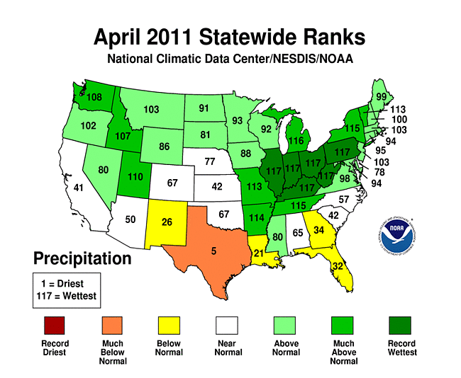
A zonal storm track was associated with the westerly flow, effectively dividing the country into above-normal precipitation across much of the northern half and below-normal rainfall across the southern tier. By the end of the month, wet soils dominated the northern U.S. and dry soils much of the southern U.S., where intensifying drought and widespread wildfires plagued the southern Plains. Texas had the 5th driest April in the 117-year record. The storm track repeatedly tapped Gulf of Mexico moisture in a southerly surface airflow that generated storm systems week after week over the Midwest. The resulting well-above-normal rainfall culminated in widespread record flooding in the Ohio Valley by the end of the month. Some areas received up to 20 inches of rain during the month, which is nearly half their normal annual precipitation. Six states (Illinois, Indiana, Kentucky, Ohio, Pennsylvania, and West Virginia) had the wettest April on record. Snow cover was confined to the northern areas and mountainous West. Snow cover peaked on April 20th when 22 percent of the contiguous U.S. was snow covered, but the month ended with only 10 percent coverage. Based on monthly average snow cover extent, April 2011 ranked as the 8th snowiest April in the 45-year satellite record for the contiguous U.S., and 10th snowiest April for North America.
April temperatures averaged below normal across the northwestern half of the country and above normal from the southern Plains to the Northeast, reflecting a westerly circulation that extended further south -- but was stronger -- than normal. The three states in the Pacific Northwest (Washington, 2nd coldest; Oregon 5th; Idaho, 10th) had the 10th coldest, or colder, April, while 9 states in the South and East ranked in the top 10 warmest category, with Delaware claiming its warmest April on record. This temperature pattern reflected a storm system orientation that contributed to the stormy weather east of the Rockies. On a national scale, April 2011 ranked as the 39th warmest and 10th wettest April in the 1895-2011 record.
Cold fronts and low pressure systems moving in the storm track flow are influenced by the broadscale atmospheric circulation. Four such large-scale atmospheric circulation patterns were dominant during April. The first was a weakening La Niña, which is the phenomenon created by cooler-than-average sea surface temperatures in the eastern tropical Pacific Ocean. At this time of year, La Niña is typically associated with cold temperature anomalies in the Northwest, warm anomalies in the South, and dry anomalies across most of the country. The second atmospheric circulation index was the Pacific/North American (PNA) pattern, which was negative for most of the month. A negative PNA this time of year is typically associated with warmer-than-normal temperatures over the southeast third of the U.S. and colder-than-normal temperatures in the Northwest. Precipitation is not strongly correlated. The third atmospheric circulation index was the North Atlantic Oscillation (NAO) pattern, which was positive for most of the month. A positive NAO this time of year is typically associated with warmer-than-normal temperatures across most of the country and drier-than-normal conditions in the Southeast and parts of the central and western U.S. The fourth atmospheric circulation index was the Arctic Oscillation (AO) pattern, which was alsopositive for most of the month. A positive AO this time of year is typically associated with warmer-than-normal temperatures across the central U.S. and drier-than-normal conditions across parts of the central and southeastern U.S.
The pattern of observed temperature anomalies for April 2011 generally matched the La Niña and PNA patterns for April (mid-spring), with some correlation to the NAO and AO patterns. The April precipitation pattern generally matched the mid-spring La Niña, NAO, and AO patterns in the southern Plains and Southeast. But the above-normal precipitation pattern for April 2011 in the Midwest and Northwest is closer to the mid-winter instead of mid-spring La Niña, PNA, and AO patterns.
- Climate Highlights - April
- The average U.S. temperature in April was 52.9 degrees F (11.6 degrees C), which is 0.9 degrees F (0.5 degrees C) above the long-term (1901-2000) average. April precipitation was 0.7 inch (18 mm) above the long-term average, the tenth wettest such month in 117 years of data.
- April was a month of historic climate extremes across much of the United States, including: record breaking precipitation that resulted in historic flooding; recurrent violent weather systems that broke records for tornado and severe weather outbreaks; and wildfire activity that scorched more than twice the area of any April this century.
- The Central climate region had its wettest April on record and it was the second wettest for the Northeast. Illinois, Indiana, Kentucky, Ohio, West Virginia, and Pennsylvania each had their wettest April since records began in 1895. An average of 11.88 inches (302 mm) of precipitation fell across Kentucky — nearly three times its long-term average — breaking the Commonwealth's previous record (7.61 inches or 193 mm, in 1972) by more than four inches (102 mm).
- In Texas, drought intensified, as the state had its fifth driest April on record. The Lone Star State has not experienced above-average precipitation since September 2010. Based on the U.S. Drought Monitor, 94 percent of the state is classified as in Severe drought (called the D2 category) to Exceptional drought (D4, the most intense designation).
- Nationally, the overall drought footprint across the contiguous U.S. remained above average, but decreased slightly from the beginning of the month to about 22 percent. The area of the country affected by the two most intense drought categories (D3, Extreme and D4, Exceptional) has increased for ten consecutive weeks, a streak dating to mid-February. Much of this very intense drought is focused in the Southern Plains and Southern Rockies.
- Ideal wildfire conditions prevailed across portions of the Southern Plains during April, and a record breaking 1.79 million acres burned across the country during the month. Texas, where over 2.2 million acres have burned since January, again bore the brunt of the wildfire activity.
- Several violent tornado outbreaks affected the country during April. According to data from NOAA's Storm Prediction Center, the number of confirmed tornadoes for the month may approach the previous all time monthly record of 542 tornadoes which struck the U.S. in May 2003.
- Much of the southern and eastern U.S. experienced above-normal warmth in April. Based on preliminary data, Delaware had its warmest such month since records began in 1895. It was the fourth warmest April for Virginia and the fifth warmest for Texas. Other states with much above normal warmth include Florida and Louisiana (7th warmest), New Mexico and West Virginia (8th), New Jersey (9th) and Maryland (10th).
- The Northwest was much cooler-than-normal during April. Washington (2nd coolest), Oregon (5th coolest) and Idaho (10th coolest) were all much cooler than normal. Washington had the greatest negative anomaly, 5 degrees F below their long-term average.
- Climate Highlights - Rolling Three-, Six-, and 12-month Periods
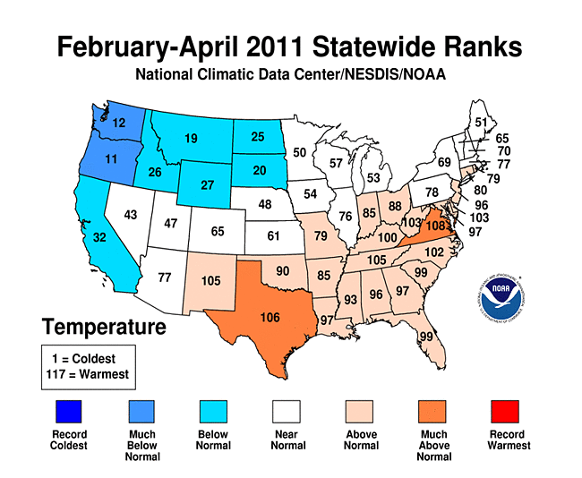
- Regionally, February-April 2011 was the wettest such period on record for the Northeast and Central climate regions. Within those regions several states experienced statewide precipitation records: Indiana, Kentucky, Ohio, New York, and Pennsylvania. Other states with much-above-average precipitation for the period were: West Virginia (2nd wettest), Illinois and Vermont (3rd), Michigan (5th), Missouri (6th), and Washington (9th).
- Exceptionally dry conditions have parched the soil and vegetation in Texas, which has recorded precipitation of just 1.68 inches (43 mm) on average across the state since February 1st. This is easily its driest February-April period on record for the state, nearly an inch less than the previous record (2.56 inches or 65 mm, Feb-Apr 1996). Also much drier-than-normal: New Mexico (7th driest) and Louisiana (8th driest).
- Temperatures during the past three months, when averaged across the nation, were near the 20th century average. However, much like April, the Northwest was cooler-than-normal while a large swath of the southern and eastern U.S. were above- to much-above normal.
- According to NOAA's Climate Prediction Center, La Niña conditions continued through April 2011 and are expected to transition to neutral conditions by early summer. The February-April U.S. temperature and precipitation patterns were largely consistent with those commonly associated with an early spring La Niña episode.
- The persistent dryness in Texas can also be traced back to the six-month period - their second driest such period. It was the sixth driest November-April period for New Mexico and the tenth driest for both Louisiana and Oklahoma.
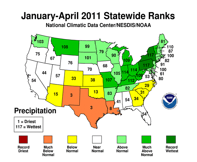
- The rolling 12-month (May-April) period show record wet for Minnesota, North Dakota and Wisconsin. The Great Lakes area had their wettest such period and it was much above normal in the Northeast, Central, Upper Great Plains, Northern Rockies and Northwest regions.
- Above average warmth has occupied much of the nation during the 12-month period. Only Montana, Oregon and Washington experienced average temperatures that were below the 20th century average.
- Climate Highlights - Year-to-Date Period
- The four-month average that makes up the year-to-date period has been above to much above normal for precipitation across the northern tier of the country. Record precipitation averages in New York and Pennsylvania contrasted with the third driest such periods in Texas and New Mexico.
| Location | Record | Amount | Previous Record (year) |
|---|---|---|---|
| Central Climate Region | Most April Precipitation | 8.41" | 6.82" (1927) |
| Illinois | Most April Precipitation | 7.31" | 7.13" (1957) |
| Indiana | Most April Precipitation | 9.22" | 7.01" (1947) |
| Kentucky | Most April Precipitation | 11.88" | 7.61" (1972) |
| Ohio | Most April Precipitation | 7.42" | 6.26" (1964) |
| Pennsylvania | Most April Precipitation | 7.59" | 6.47" (1993) |
| West Virgina | Most April Precipitation | 7.43" | 7.11" (1901) |
| Delaware | Warmest April | 58.1°F | 57.9°F (1994) |
| Central Climate Region | Most Feb-Apr Precipitation | 16.35" | 15.82" (1945) |
| Northeast Climate Region | Most Feb-Apr Precipitation | 14.02" | 13.89" (2008) |
| Texas | Least Feb-Apr Precipitation | 1.69" | 2.56" (1996) |
| Indiana | Most Feb-Apr Precipitation | 16.61" | 15.33" (2008) |
| Kentucky | Most Feb-Apr Precipitation | 22.05" | 20.42" (1909) |
| New York | Most Feb-Apr Precipitation | 13.81" | 13.30" (2008) |
| Ohio | Most Feb-Apr Precipitation | 15.68" | 15.61" (1964) |
| Pennsylvania | Most Feb-Apr Precipitation | 16.74" | 14.01" (1993) |
| East North Central Region | Most May-Apr Precipitation | 39.34" | 35.63" (1994) |
| Minnesota | Most May-Apr Precipitation | 35.68" | 32.96" (2006) |
| North Dakota | Most May-Apr Precipitation | 24.26" | 23.84" (1942) |
| Wisconsin | Most May-Apr Precipitation | 42.88" | 39.48" (1973) |
| United States | Most April Tornadoes Most Tornadoes in a Single Month |
875 Preliminary Tornado Reports* | 267 Tornadoes (April 1974) 542 Tornadoes (May 2003) |
| United States | Largest Tornado Outbreak | 305 Estimated Tornadoes April 25-28* | 148 (April 1974) |
| Wisconsin | Largest Tornado Outbreak in April | 14 Confirmed - April 10 | 10 Tornadoes (April 27, 1984) |
| North Carolina | Largest Tornado Outbreak | 30 Confirmed - April 16 | 22 Tornadoes (March 28, 1984) |
| Contiguous United States | Most Acres Burned by Wildfire in April | 1.79 Million Acres | 758,000 Acres (April 2008) |
*All numbers are preliminary unless otherwise stated. The number of confirmed tornadoes will be considerably less than the number of preliminary reports.
Alaska Temperature and Precipitation:
-
 Alaska
had its 34th coolest April on record, with a temperature 1.6°F (0.9°C) below the 1971–2000 average.
Alaska
had its 34th coolest April on record, with a temperature 1.6°F (0.9°C) below the 1971–2000 average.
-
 Alaska
had its 43rd coldest February–April on record, with a temperature 0.7°F (0.4°C) below the 1971–2000 average.
Alaska
had its 43rd coldest February–April on record, with a temperature 0.7°F (0.4°C) below the 1971–2000 average.
-
 Alaska
had its 38th warmest year-to-date period on record, with a temperature 0.5°F (0.3°C) above the 1971–2000 average.
Alaska
had its 38th warmest year-to-date period on record, with a temperature 0.5°F (0.3°C) above the 1971–2000 average.
-
 Alaska
had its 45th driest April since records began in 1918, with an anomaly that was 5.2 percent below the 1971–2000 average.
Alaska
had its 45th driest April since records began in 1918, with an anomaly that was 5.2 percent below the 1971–2000 average.
-
 Alaska
had its 38th wettest February–April on record, with an anomaly that was 14.5 percent above the 1971–2000 average.
Alaska
had its 38th wettest February–April on record, with an anomaly that was 14.5 percent above the 1971–2000 average.
-
 Alaska
had its 37th wettest year-to-date period on record, with an anomaly that was 11.8 percent above the 1971–2000 average.
Alaska
had its 37th wettest year-to-date period on record, with an anomaly that was 11.8 percent above the 1971–2000 average.
For additional details about recent temperatures and precipitation across the U.S., see the Regional Highlights section below. For information on local temperature and precipitation records during the month, please visit NCDC's Records page. For details and graphics on weather events across the U.S. and the globe please visit NCDC's Global Hazards page.
Regional Highlights:
These regional summaries were provided by the six Regional Climate Centers and reflect conditions in their respective regions. These six regions differ spatially from the nine climatic regions of the National Climatic Data Center.
- Northeast Region: (Information provided by the Northeast Regional Climate Center)
- Temperatures in the Northeast averaged 47.3 degrees F (8.5 degrees C) which was 1.1 degrees F (0.6 degrees C) above normal. This was the 4th consecutive April with above normal temperatures. Since 2002, all but two years, 2003 and 2007, have had warmer than normal April averages. Of the twelve states in the region, only Maine averaged below normal, with a departure of -0.6 degrees F (). Warmer-than-normal temperature departures ranged from +0.3 degrees F (-0.3 degrees C) in Vermont to +4.5 degrees F (+2.5 degrees C) in Delaware. It was the warmest April since 1895 in Delaware, the 9th warmest in New Jersey and West Virginia and the 10th warmest in Maryland.
- Precipitation totals were above normal for the third month in a row. The region averaged 6.17 inches (157 mm), which was 169 percent of normal. It was the 2nd wettest April in the Northeast in 117 years. Pennsylvania and West Virginia saw their wettest April since 1895; New York ranked 3rd wettest; and Vermont had its 5th wettest April since recordkeeping began 117 years ago. Southern Delaware and Maryland?s Eastern Shore received the least amount of precipitation this month, however, abundant rainfall in the rest of both states left them with above normal averages: 108 percent of normal in Delaware and 128 percent in Maryland. Wet conditions throughout West Virginia and Pennsylvania yielded totals that were 197 percent of normal and 211 percent of normal, respectively. Precipitation departures during April in the remaining states fell within this range and all of the states except Delaware ranked within the top 25 wettest in 117 years. Looking at the totals for the last two and three-month periods, precipitation totals for March and April in New York, Pennsylvania and West Virginia were the greatest recorded in those states in 117 years. The Northeast and the individual states of New York and Pennsylvania saw their wettest February through April since recordkeeping began in 1895.
- The forecasted April Fools Day snowstorm had potential to be the story of the month, but the storm did not live up to its expectations. The forecast for severe weather on the 28th did pan out and, while the impacts of the storms that day pale in comparison to the devastation in the southern U.S., the Northeast tallied at least 16 tornados and two microbursts on that day. Pennsylvania and New York each had 6 tornados, ranging in strength from EF0 to EF2 on the Enhanced Fujita Scale. Damage included uprooted or snapped trees, one destroyed mobile home and several destroyed barns and outbuildings, structural damage to homes, and injured or killed livestock. Several high voltage transmission towers in Pennsylvania were toppled by the tornados. Maryland had 4 confirmed tornados, including an EF0 tornado on the Andrews Air Force Base. Damage in Maryland was minimal as the storms were in the EF0 to EF1 categories.
- For more information, please go to the Northeast Regional Climate Center Home Page.
- Midwest Region: (Information provided by the Midwest Regional Climate Center)
- April precipitation totals were above average for most of the Midwest and two to four times normal in an area extending from southern Missouri eastward up the Ohio River valley. Totals were also several times normal in northern Michigan. Much of the precipitation in the southern Midwest fell during the last ten days of the month, swelling the Ohio and Mississippi rivers with runoff. Among Cooperative Network stations with a period of record (POR) of 90 or more years, seven recorded their wettest month ever. Forty-nine such stations recorded their wettest April. The stations that recorded their wettest month ever were 1) Poplar Bluff, Missouri, 21.39 inches (543 mm), old record 15.32 inches (389 mm) in October 2009, 103 year POR, 2) Du Quoin 4SE, Illinois, 16.90 inches (429 mm), old record 15.20 inches (386 mm) in June 1998, 117 year POR, 3) Portsmouth, Ohio, 14.62 inches (371 mm), old record 12.77 inches (324 mm) in January 1937, 109 year POR, 4) Fairfield, Ohio, 14.11 inches (358 mm), old record 13.96 inches (355 mm) in January 1937, 96 year POR, 5) Chester, Illinois, 13.94 inches (354 mm), old record 13.56 inches (344 mm) in July 1905, 109 year POR, 6) Olney 2S, Illinois, 13.31 inches (338 mm), old record 12.79 inches (325 mm) in May 1943, 116 year POR, and 7) Farmers 2 S, Kentucky, 12.53 inches (318 mm), old record 12.49 inches (317 mm) in May 2010, 106 year POR. Relaxing the criteria to include stations with 30 or more years in the POR puts 26 stations on the wettest month ever list and 151 stations on the wettest April list.
- April temperatures were above average across the Midwest for the first half of the month. In the second half of the month, temperatures remained above normal in Kentucky and southeastern Ohio but the rest of the Midwest was below normal. Averaged over the month, temperatures were above normal south of a line from Kansas City, Missouri to Toledo, Ohio and below normal north of that line. Departures ranged up to 4 degrees F (2 degrees C) above normal in Kentucky but just down to -2 degrees F (-1 degrees C) in the north. Maximum temperatures were especially cold in the second half of the month, with negative departures of 11 degrees F to 13 degrees F (6 degrees C to 7 degrees C) in parts of Iowa, Minnesota, and Wisconsin.
- Early in the month flooding was a problem in Minnesota in particular. The Red River reached major flood stage for the third straight spring. Flood waters in the Mississippi River basin moved down stream through the month and were along the Illinois-Missouri border by the end of the month. The heavy downpours in the Ohio River basin swelled the Ohio River and its tributaries late in the month and this water reached the confluence with the Mississippi River with both flooded. Cairo, Illinois, located on the Ohio River near the confluence with the Mississippi, matched the record 1937 flood crest just as the month was ending and the waters were still rising.
- Severe weather was plentiful in the Midwest with reports on 21 days in April. Although the Midwest was spared the killer tornadoes that occurred in the southern states, there were dozens of tornadoes in the Midwest that did considerable damage. Hail and thunderstorm winds also added to the destruction. Tornadoes were reported in each Midwest state except Minnesota and on 11 days, including six straight days from the 22nd to the 27th.
- For details on the weather and climate events of the Midwest, see the weekly summaries in the MRCC Midwest Climate Watch page.
- Southeast Region: (Information provided by the Southeast Regional Climate Center)
- Mean temperatures in April were between 3 and 5 degrees F (1.6 and 2.8 degrees C) above normal across most of the Southeast region. It was the warmest April in Miami, FL and Cape Hatteras, NC in records extending back to 1898 and 1933, respectively. April ranked among the top 5 warmest in many other locations across the Southeast, including Orlando, FL, Charleston, SC, Raleigh-Durham, NC, and Richmond, VA. Across the region, there were 386 daily maximum and 696 daily high minimum temperature record tied or broken during the month. During the Masters Golf Tournament on the 9th of the month, Augusta, GA recorded a daily maximum temperature of 91 degrees F (32.8 degrees C), which was 1 degree F (0.5 degrees C) shy of tying the all-time highest temperature recorded during the event since 1932. For the second straight month, mean temperatures were close to normal across Puerto Rico, while the U.S. Virgin Islands experienced their sixth straight month of below normal temperatures.
- As in March, precipitation totals were highly variable across the Southeast region. The wettest locations (200 to 300 percent of normal) were again found across northern Alabama and Georgia, as well as western North Carolina and Virginia. Huntsville, AL recorded 10.11 inches (256.8 mm) of precipitation for the month, making it the 5th wettest April in a record extending back to 1895. Persistent southerly flow ahead of several strong frontal systems contributed to a second straight month of above normal rainfall in parts of the southern Appalachian Mountains. Lake Toxaway, NC recorded 7.30 inches (185.4 mm) of precipitation on the 16th of the month, which broke the previous monthly 24-hr rainfall total of 5.59 inches (141.9 mm). For the month, Lake Toxaway recorded 11.78 inches (299.2 mm) of precipitation, marking the second straight month with more than 10 inches (254 mm) of precipitation. Heavy rainfall associated with a series of severe thunderstorms contributed to corridors of slightly above normal monthly precipitation totals across central portions of the Southeast. Conversely, it was a dry April across southern portions of Alabama and Georgia, eastern sections of North Carolina and Virginia, and nearly all of Florida, with precipitation totals only 25 to 75 percent of normal for the month. The driest locations (less than 25 percent of normal) were found across southern and eastern Florida and eastern sections of Georgia and South Carolina. Monthly precipitation was 50 to 75 percent of normal across the northern and southern coasts of Puerto Rico, but more than 200 percent of normal across the island interior.
- April 2011 was an historic month for severe weather across the Southeast region. In total, there were 1,877 reports of severe weather, including 323 reports of tornadoes. This is the greatest number of severe weather reports for any month in the Southeast region since 2000. The majority of the reports were issued during four separate outbreaks. The first occurred on the 4th and 5th of the month, as a large squall line raced across the region. Several weak to moderate tornadoes touched down in Georgia, killing seven people and causing hundreds of thousands of power outages. Widespread wind damage was also reported from the Gulf Coast to the mid-Atlantic region. The ASOS station at the Columbia Metro Airport in South Carolina recorded a 75 mph (120 km/hr) wind gust on the morning of the 5th, which tied for the fastest speed ever recorded at that station. The second outbreak occurred on the 8th and 9th, as a cluster of strong storms produced a few weak tornadoes and swaths of large hail, several of which were baseball-size, across Virginia and the Carolinas. On the 15th and 16th of the month, a strong cyclonic system brought another, more significant round of severe weather to the Southeast. There were 90 confirmed tornadoes from this outbreak, with most occurring in Alabama and North Carolina. Three of the tornadoes in Alabama were fatal, including an EF-3 that killed four people in the Deer Park community north of Mobile. However, the greatest impact from this event was felt in North Carolina, which experienced its worst tornado outbreak since March 1984. There were 30 confirmed tornadoes across the state, the most ever from a single outbreak in North Carolina, resulting in 24 deaths. Half of these deaths occurred in a mobile home community in Bertie County in the northeastern part of the state. Perhaps the most notable tornado from this outbreak was an EF-3 that completely destroyed a Lowes hardware store in Sanford and then destroyed several structures near downtown Raleigh. In Virginia, 12 tornadoes were confirmed from this outbreak, including an EF-3 that resulted in two deaths in the Tidewater region near Clopton. The most significant outbreak of the month occurred from the 26th to the 28th, as another strong cyclonic system helped spawn numerous supercell thunderstorms across the southern U.S. The greatest impact was felt in Alabama, where 30 tornadoes contributed to over 200 deaths across the state. Nearly half of the confirmed deaths were associated with two major tornadoes. One was an EF-4 that killed 65 people along an 80 mile (128 km) track that took it through the cities of Tuscaloosa and Birmingham. According to NOAA, these are the most fatalities from a single tornado in the U.S. since May 25, 1955. Over 5,700 structures were destroyed in Jefferson County (Birmingham), with damage estimates approaching $750 million. The strongest tornado from this outbreak was an EF-5 that tracked over 130 miles from northwest Alabama to southern Tennessee. This tornado was responsible for 36 deaths in the town of Hackleburg, AL. In Georgia, there were 15 tornadoes confirmed from this outbreak, including an EF-4 that struck the town of Ringgold near the Tennessee border. Fifteen deaths have been confirmed in Georgia from this outbreak. In southwest Virginia, an EF-3 tornado caused extensive damage and resulted in three fatalities near the town of Glade Springs. The severity of this outbreak may equal or exceed that of the April 1974 Super Outbreak, however, the exact number of tornadoes and deaths is still being determined.
- Despite generally below average rainfall in April, drought conditions improved slightly throughout the month across the Southeast region. Areas of moderate drought (D1) were eliminated across the Shenandoah Valley of Virginia, while the region of extreme drought (D3) in southeast Georgia was reduced to severe drought (D2). The overall warmth and dryness in April helped farmers across Georgia and Florida prepare for the planting of cotton and peanuts, though declines in pasture and leafy vegetables were reported. The continued dryness across south Florida and Puerto Rico forced some communities to begin implementing water restrictions.
- For more information, please go to the Southeast Regional Climate Center Home Page.
- High Plains Region: (Information provided by the High Plains Regional Climate Center)
- Temperatures were generally warmer than normal in the south and cooler than normal in the north across the High Plains Region this month. The majority of Colorado and Kansas were warmer than normal and average temperatures were up to 5.0 degrees F (2.8 degrees C) above normal. While the warmth was not record breaking, the persistent dry weather in western and south-central Kansas has stressed the winter wheat crops and caused them to decline. Meanwhile, April was the fifth month in a row in which average monthly temperatures were cooler than normal in the Dakotas. Each state had average monthly temperatures which ranged from near-normal to 5.0 degrees F (2.8 degrees C) below normal. In addition, locations in these states generally ranked in the top 25 coolest Aprils on record. The Theodore Roosevelt Airport in Dickinson, North Dakota had its 19th coolest April on record with an average temperature of only 38.8 degrees F (3.8 degrees C) which was 4.0 degrees F (2.2 degrees C) below normal (period of record 1948-2011). The record was set in 1950 with an average temperature of 31.9 degrees F (-0.1 degrees C). The cool, wet weather has delayed or slowed fieldwork and planting in not only the Dakotas, but also in Nebraska. In Wyoming, these conditions have delayed mountain snowmelt and allowed the snowpack to continue to grow. In addition, the snow water equivalency of the snowpack at the end of the month was 154 percent of average. The combination of these factors has raised concerns of flooding in southeastern parts of the state.
- When compared to other areas of the country, April was a relatively quiet month and winter still had its grip on much of the High Plains Region. Several systems that moved through the Region brought a wide variety of conditions, including snow, ice, high winds, hail, flooding, and tornadoes. A major system passed through the Region April 14-15. Heavy wet snow and high winds created treacherous blizzard conditions in western Nebraska, eastern Colorado, and northwestern Kansas. Interstate 80 was closed, as were local schools. In addition, several communities lost power. In South Dakota, several locations reported up to a foot (30 cm) of new snowfall and, according to the National Weather Service office in North Platte, Nebraska, snow drifts of 7-10 feet (213-305 cm) occurred with this storm. This same system brought severe weather to central Kansas. Damaging straight line winds, hail as large as tennis balls, and tornadoes were all reported.
- By the end of the month many locations in North Dakota had snowfall totals that ranked in the top 10 snowiest Aprils. Bismarck, North Dakota had its 5th snowiest April on record with 13.4 inches (34 cm) (period of record 1886-2011). Bismarck's record occurred in 1984 with 18.7 inches (47 cm). With 12.6 inches (32 cm) of snow, Williston, North Dakota had its 6th snowiest April on record and pushed its record-breaking seasonal snowfall total up to 107.2 inches (272 cm). Williston's April record occurred in 1896 with 26.6 inches (68 cm) (period of record 1894-2011). South Dakota's seasonal snow totals increased this month as well. With an April snowfall of 0.7 inches (2 cm), Sisseton, South Dakota's seasonal snowfall total came to 82.7 inches (210 cm) which surpassed the old record of 82.3 inches (209 cm) set in the 1993-1994 snow season (period of record 1900-2011).
- As expected, flooding did occur along the Red River this month. On the 9th, the Red River crested at Fargo, North Dakota at 38.75 feet which was the 4th highest on record (period of record 1897-2011). The record occurred on March 28, 2009 when the river crested at 40.84 feet. On April 14th, the Red River crested at 49.87 feet at Grand Forks, North Dakota which was the 3rd highest crest on record (period of record 1883-2011). The highest crest on record occurred on April 22, 1997 at 54.35 feet. According to the North Dakota State Climate Office, many roads and parts of the interstate were closed due to the flooding.
- There were some significant changes to the U.S. Drought Monitor over the past month. Generally, drought conditions worsened in Colorado and Kansas and improved in Nebraska and Wyoming. The Dakotas remained drought free. Drought conditions deteriorated along the Kansas-Colorado border where extreme drought conditions (D3) were introduced. Severe drought conditions (D2) also expanded from Oklahoma into south-central Kansas. The state of Nebraska had many improvements over the past month as much needed rainfall helped eliminate the moderate drought conditions (D1) in the south central part of the state and abnormally dry conditions (D0) in the central and eastern portions of the state. D0 was also eliminated in northern Wyoming due to increased precipitation and an above normal snowpack. According to the U.S. Seasonal Drought Outlook released April 21st drought conditions across Colorado and Kansas were expected to persist.
- For more information, please go to the High Plains Regional Climate Center Home Page.
- Southern Region: (Information provided by the Southern Regional Climate Center)
- In accordance with last month, April was a consistently warmer than normal month throughout the Southern Region. In Arkansas, Tennessee, Mississippi and Oklahoma, average daily temperatures for the month ranged between 2-6 degrees F (1.11- 3.33 degrees C) above expected values. In Louisiana and most of Texas, temperatures averaged between 4-6 degrees F (2.22-3.33 degrees C) above normal. The warmest part of the region for the month was in central Texas, where daily temperatures averaged 6-8 degrees F (3.33-4.44 degrees C) above normal. With an average temperature of 70.10 degrees F (21.17 degrees C), Texas experienced its fifth warmest April on record (1895-2011). Louisiana experienced its seventh warmest April on record (1895-2011) with a state average temperature of 70.40 degrees F (21.33 degrees C). Elsewhere in the region, Tennessee averaged 61.10 degrees F (16.17 degrees C), Mississippi averaged 66.70 degrees F (19.28 degrees C), Oklahoma averaged 61.70 degrees F (16.5 degrees C) and Arkansas averaged 63.30 degrees F (17.39 degrees C). For Tennessee, it was the thirteenth warmest April on record (1895-2011), while for Mississippi, it was the eighteenth warmest on record (1895-2011). Arkansas experienced its twentieth warmest April on record (1895-2011) and Oklahoma experienced its twenty-forth warmest April (1895-2011).
- April precipitation totals varied considerably across the Southern Region. Arkansas and Tennessee experienced extreme wetness, while extreme dryness dominated southern and western Texas. In Arkansas and Tennessee, April precipitation totals for the majority of stations varied between 150 and 400 percent of normal. This was also the case for the northern quarter of Mississippi and the eastern tip of Oklahoma. Most of the stations in Tennessee reported over 7 inches (177.80 mm) of precipitation for the month, with many reporting over 10 inches (254.00 mm). In Arkansas, conditions were equally as wet, with most stations reporting over 8 inches (203.2 mm) of precipitation. In fact, in Arkansas, over a dozen stations reported over 14 inches (355.60 mm) of precipitation for the month. The state of Tennessee averaged a total of 9.22 inches (234.19 mm), making it the third wettest April on record (1985-2011). For Arkansas, it was the fourth wettest April on record (1895-2011) with a state average precipitation value of 10.46 inches (265.68 mm). Mississippi and Oklahoma averaged near normal precipitation totals with values of 6.13 inches (155.70 mm) and 3.30 inches (83.82 mm), respectively. In Louisiana, conditions were relatively dry throughout the month. The state averaged only 2.61 inches (66.29 mm) of precipitation, making it the twenty-first driest April on record (1895-2011). In Texas, it was even drier. The state averaged only 0.75 inches (19.05 mm), which is the fifth driest April on record (1895-2011). For the state, the majority of stations in the High Plains, Trans Pecos, Rolling Plains, South Central, Southern and Lower Valley Climate divisions reported a precipitation total of 0 inches (0 mm).
- Spatially variable April precipitation totals in the Southern Region has led to dramatic changes in drought conditions over the past month. Extremely wet conditions in Tennessee has kept the state drought free. Similar wetness in Arkansas has led to a considerable improvement in drought conditions. As of May 3, 2011, only a small strip along the southern tip of Arkansas is classified as drought. The majority of the state, which last month was showing moderate to extreme drought, is now drought free. Drought conditions in Mississippi have not changed much over the past month. Anomalously high precipitation totals in the northern areas of the state has resulted in a one category improvement, while drier than normal conditions in the south led to a one category deterioration. Contrary to what has occurred in Tennessee and Arkansas, the remainder of the region has shown dramatic deterioration in drought conditions. Much of west central Texas is now in exceptional drought, as is east central Texas. This is also the case for part of the Oklahoma panhandle and west central Louisiana. Extreme drought has also expanded in central Oklahoma, northern Texas, southern Louisiana and southern Mississippi. These dramatic changes in drought conditions are primarily the result of low precipitation totals, coupled with higher than normal temperatures and the subsequent high water demands with which warmer-than-normal conditions are associated. As of May 3, 2011, 14.68 percent of the Southern Region is experiencing exceptional drought, while 46.58 percent of the region is experiencing extreme drought conditions or worse. In addition, 64.13 percent of the region is experiencing severe drought conditions or worse, and 71.52 percent of the region is in moderate drought or worse.
- On April 4, 2011, an EF2 Tornado in Hempstead County, Arkansas resulted in two injuries. In Louisiana, another tornado led to an injury in Tensas Parish. Several homes were destroyed.
- On April 14, 2011, two people died as a result of a tornado in Atoka County, Oklahoma. On the same day, three people were injured due to a tornado in Le Flore County, Oklahoma. Several homes were also destroyed and damaged. In Arkansas, two people were injured and two were killed as tornadoes ripped through Franklin and Pulaski Counties.
- Heavy rainfall in the final week of the month resulted in at least eight deaths in Arkansas. The Arkansas Democrat Gazette reported that levees on the Black River in Pocahontas, Arkansas have been breached, resulting in wide spread flooding. The flooding has resulted in the periodic closure of US Route 67. Governor Mike Beebe has declared 63 of the 75 counties in the state as disaster areas.
- Wildfires plagued the state of Texas throughout the month. Several town were evacuated and dozens of homes have been destroyed. Several fires have burned hundreds of thousands of acres. The most significant fire has been the Rockhouse fire. This fire began on April 9, located just outside the town of Marfa, Texas. This fire has destroyed over forty homes and has burned over 313,000 acres (1266.67 square kilometers) of land. Odesa America Online has reported that this is the largest wildfire in Texas history. Other fires include: one near Aspermont, Texas, which has burned over 122,000 (493.72 square kilometers) acres of land; one fire in Tom Green County which has burned over 160,000 acres (647.50 square kilometers) of land; one just outside of San Angelo which has burned over 12,000 acres (48.56 square kilometers) of land; one fire in Kent, Fisher, Scurry and Stonewall Counties which has burned over 160,000 acres (647.50 square kilometers) of land; and another fire in Val Verde County which has burned over 150, 000 acres (607.03 square kilometers) of land.
- Dozens of Tornadoes touched down in the south between the dates of April 25 to 27, 2011. The tornadoes have resulted in at least thirteen deaths in Arkansas, two deaths in Louisiana, thirty-four deaths in Mississippi, and thirty-four deaths in Tennessee. In Smithville, Mississippi, an EF5 tornado touched down on April 27, 2011. The twister was reported to have destroyed over 150 homes. Twenty-seven people are believed to have died as a result. Winds from the twister were estimated at 205 miles per hour (329.91 kilometers per hour). A strong EF4 tornado touched down on April 27 in Hamilton and Bradley Counties in Tennessee. Dozens of homes were destroyed and approximately twenty people were killed. Winds were estimated at 175-190 miles per hour (281.63-305.77 kilometers per hour).
- For more information, please go to the Southern Regional Climate Center Home Page.
- Western Region: (Information provided by the Western Regional Climate Center)
- Temperatures were distinctly different across the West, being generally above normal in the southeastern third and cooler to much cooler than normal in the northern two-thirds. Some locations in Washington reported temperatures of 8 degrees F (4 C) below normal while various locations in New Mexico were 6-8 degrees F (3-4 C) above normal.
- Precipitation was a mixed bag with pockets of wet and dry throughout the region. Generally, the northern half was wetter and the southern half drier, especially New Mexico and California. Parts of NE Montana were 300% of normal for the month while numerous locations in California, Nevada, Arizona and New Mexico recorded little or no rainfall. As a consequence the southern half of New Mexico and a portion of southeast Arizona were in extreme drought. A large local rain event hit the Oregon-California border coast on the 15-16th with some locations receiving nearly 10 inches (254 mm) of rain.
- Thanks to a mostly cool and cloudy April and consequent minimal runoff, mountain snowpack remained quite healthy with most mountain sensors reporting well over 100% of normal by the end of the month. Only Arizona and New Mexico had below normal snow pack. Glasgow MT added 3.3 inches (8 cm) to its record seasonal snowfall of 108.6 inches (276 cm), 372 percent of its 29.2 inch (74 cm) average through April. The central Sierra snowpack was near 200% of normal while most of the intermountain and Cascades were 150% or normal. On April 27th, 71 Snotel sites in the Wasatch and Uinta Ranges, and the upper Green River and Colorado River headwaters, registered the highest snow water content for the date since station installation (generally early to middle 1980s). The closely monitored April through July forecast of inflow to Lake Powell was around 119 percent of average.
- April 1-6: Wildfire near Fort Collins, CO: The Crystal Fire destroyed 13 homes just west of Fort Collins, CO, and burned nearly 3,000 acres. The fire started on the 1st and burned rapidly in the dry, windy conditions.
- April 7: Powerful storm in Alaska: A strong storm hit Alaska with winds of up to 110 mph in some areas near the Bering Sea which shut down marine and air traffic, damaged buildings and produced blizzard conditions. The cities of Kotzebue and Nome were mostly shut down to air traffic. Strong down slope winds in Anchorage downed trees and produced areas of blowing and drifting snow disrupting traffic and causing power outages to more than 5,500 residents in Palmer and Anchorage due to downed power lines.
- April 7-8: Southwest. A late season cold front hit much of the west. In Montana, up to 31 inches (78.7 cm) of snow fell in parts of Jefferson County. Although very little precipitation fell in the Southwest, conditions were quite cold and windy throughout the region, with some local damage from hail and gusty winds in excess of 70 mph in California and Nevada. A small tornado (EF0) was reported in Solano County, CA. An automated weather station in Yosemite National Park recorded a minimum temperature of -14 F (-25.5 C) on the morning of the 8th.
- April 11-16: Flooding in Northern Montana: Record winter snowfall in north central and northeast Montana led to moderate to major flooding along the Milk River. At least 11 roads in Valley and Phillips counties were under water and over 90 residences in the region faced evacuation.
See NCDC's Monthly Records web-page for weather and climate records for the most recent month. For additional national, regional, and statewide data and graphics from 1895-present, for any period, please visit the Climate at a Glance page.
PLEASE NOTE: All of the temperature and precipitation ranks and values are based on preliminary data. The ranks will change when the final data are processed, but will not be replaced on these pages. Graphics based on final data are provided on the Temperature and Precipitation Maps page and the Climate at a Glance page as they become available.