National Overview
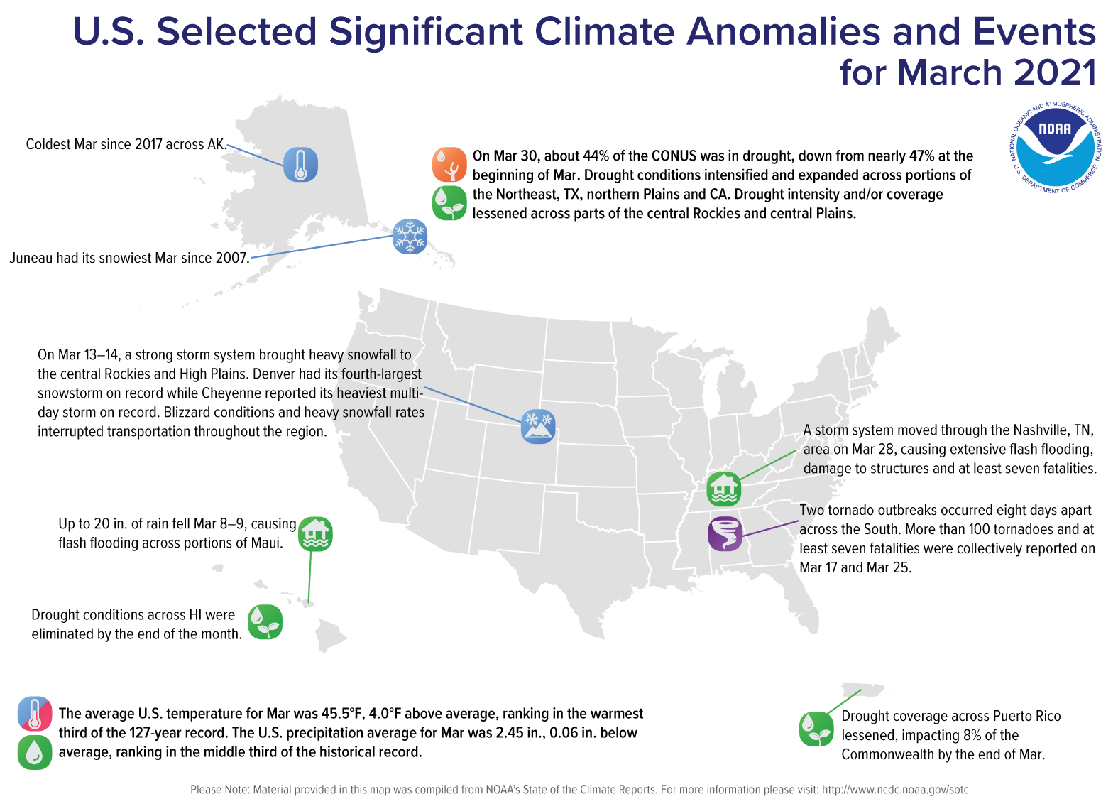
March Highlights
March Temperature
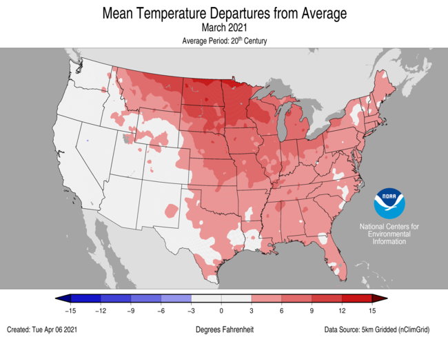
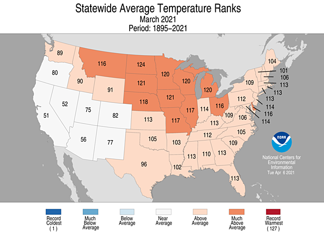
- During March, the average contiguous U.S. temperature was 45.5°F, 4.0°F above the 20th century average. This ranked in the warmest third of the 127-year period of record.
- Above-average temperatures were observed from the Northwest to the Great Lakes to the Gulf of Mexico and into the Northeast. Temperatures across North Dakota were fourth warmest on record. Below-average temperatures were present across parts of the West Coast during March.
- The contiguous U.S. average maximum (daytime) temperature during March was 57.9°F, 4.9°F above the 20th century average, ranking as the 11th warmest March on record. Above-average maximum temperatures blanketed a region from the Northwest to the Northeast to the Gulf of Mexico.
- The contiguous U.S. average minimum (nighttime) temperature during March was 33.1°F, 3.1°F above the 20th century average, ranking in the warmest third of the record. Above-average conditions were observed again from the Northern Rockies and Plains to the East Coast and to the Gulf of Mexico. Below-average minimum temperatures were observed across parts of the West.
- The Alaska March temperature was 8.9°F, 1.9°F below the long-term average. This ranked in the coldest third of the 97-year period of record for the state and was the coldest March since 2017. On average, the coldest departures from average occurred across south-central Alaska while much of the North Slope was near average. Bering Sea ice extent was 81 percent of average for March, which contributed to above-average temperatures across the Aleutians.
- During March there were approximately 3.5 times as many warm daily records as compared with cold records. As of April 6, there were 3,294 record warm daily high (1,674) and low (1,620) temperature records and 897 record cold daily high (417) and low (480) temperature records.
- Based on NOAA's Residential Energy Demand Temperature Index (REDTI), the contiguous U.S. temperature-related energy demand during March was 53 percent of average and ranked 11th lowest in the 127-year period of record.
March Precipitation
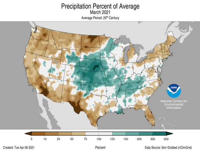
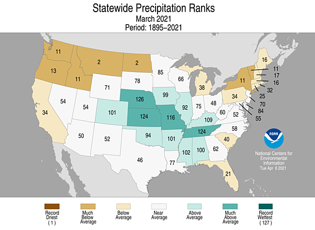
- The March precipitation total for the contiguous U.S. was 2.45 inches, 0.06 inch below average, and ranked in the middle third of the 127-year period of record.
- Above-average precipitation was observed from the central U.S. to the Tennessee Valley and Gulf Coast in March. Nebraska precipitation ranked second wettest for the month. Below-average precipitation occurred across the Northwest, northern Plains, Northeast, as well as portions of the Southeast, Deep South and West. Montana and North Dakota ranked second driest on record for the month. Portions of the northern Plains and Pacific Northwest had record dryness in March.
- A strong low pressure system brought heavy snowfall to the Rocky Mountains on March 13-14. Denver received 27.1 inches of snowfall making this event its fourth-largest snowstorm on record. Cheyenne, WY, had its heaviest multi-day snowstorm on record. The above-average precipitation received during March helped to lessen the severity of the long-term drought across the central Rockies and central Plains.
- Precipitation across Alaska during March was well above normal across western and northwestern Alaska as well as south of the Brooks Range. Juneau reported its snowiest March since 2007.
- According to the March 30 U.S. Drought Monitor report, nearly 44 percent of the contiguous U.S. was in drought, down from 46.6 percent at the beginning of March. Drought conditions intensified and expanded across portions of the Northeast, Texas, northern Plains and California. Drought intensity and/or coverage lessened across parts of the central Rockies and central Plains, as well as across Puerto Rico, and was eliminated in Hawaii.
- According to NOAA data analyzed by Rutgers Global Snow Lab, the March snow cover extent was approximately 237,000 square miles below the 1981-2010 average and ranked as the 7th smallest extent in the 55-year period of record. Above-average snow cover was observed across parts of the Pacific Northwest as well as the northern and central Rockies. Below-average snow cover was present across much of the Cascades, Great Basin, northern and central Plains, Great Lakes and parts of the Northeast.
Year-to-Date Highlights
January-March Temperature
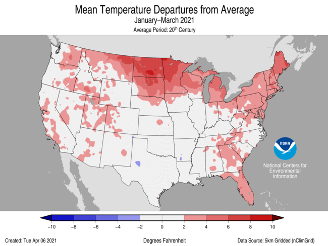
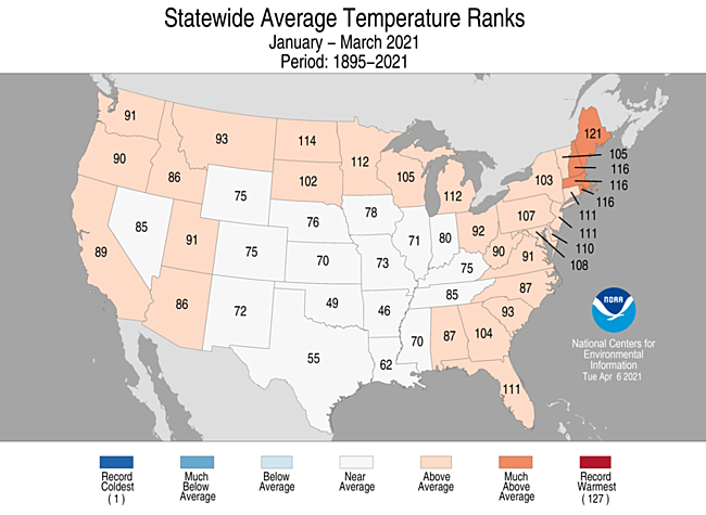
- The year-to-date (January-March) average contiguous U.S. temperature was 36.9°F, 1.8°F above average, ranking in the warmest third of the record.
- Above-average temperatures were present across the Northern Tier and Northeast as well as portions of the West and Southeast. Despite the broad extent of warmth seen during March across the Lower 48, temperatures over the first three months of the year were near average across a wide portion of the U.S. This was in large part due to the cold weather experienced during February. Below-average temperatures occurred across portions of the South.
- The contiguous U.S. average maximum (daytime) temperature during January-March was 47.6°F, 1.5°F above the 20th century average, ranking in the middle third of the historical record. Above-average conditions were observed across much of the West, northern Plains, Great Lakes, Northeast and in parts of the Southeast. Below-average daytime temperatures were present across parts of the central and southern Plains as well as the central Mississippi Valley.
- The contiguous U.S. average minimum (nighttime) temperature during January-March was 26.2°F, 2.0°F above the 20th century average, ranking in the warmest third of the record. Above-average conditions blanketed much of northern and central Plains, Great Lakes, East Coast and parts of the West.
- The Alaska January-March temperature was 6.8°F, 0.9°F above the long-term average, ranking in the middle third of the record for the state. Above-average temperatures occurred across Bristol Bay and the Aleutians during the first three months of 2021 with the remainder of the state experiencing near-average conditions.
- Based on REDTI, the contiguous U.S. temperature-related energy demand during January-March was 68 percent of average and was the 21st lowest value on record.
January-March Precipitation
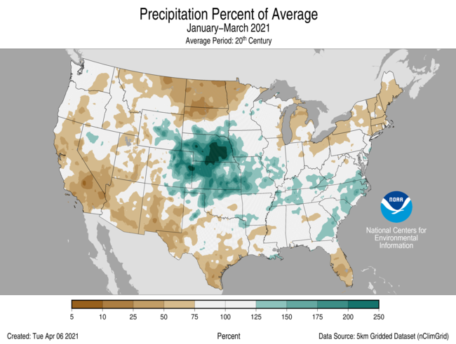
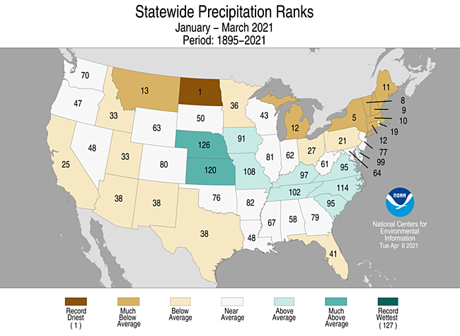
- The year-to-date precipitation total was 6.55 inches, 0.41 inch below average, ranking in the middle third of the January-March record.
- Above-average precipitation stretched from the central Plains to the East Coast during January-March. Nebraska ranked second wettest on record. Dry conditions were present across much of the West, northern Plains, Great Lakes, Northeast and parts of the South and Southeast. North Dakota ranked driest on record for this three-month period.
Extremes
-
The U.S. Climate Extremes Index (USCEI) for the year-to-date was 16 percent below average and ranked in the middle third of the 112-year period of record. Extremes in dry PDSI were above average with all other indicators near or below average for this three-month period. The USCEI is an index that tracks extremes (falling in the upper or lower 10 percent of the record) in temperature, precipitation and drought across the contiguous United States.
- On the regional scale, the Northeast, Southwest and West had CEI values which were slightly elevated. For the Northeast, extremes in warm minimum temperatures, wet PDSI and days without precipitation were above average. Across the Southwest, extremes in dry PDSI values covered the entire region and were the highest on record. Across the West, dry PDSI blanketed about 80 percent of the region, which was third highest on record.
Billion Dollar Disasters
- The first weather and climate disaster of 2021 to exceed the billion-dollar threshold was associated with the cold wave that occurred across the central United States in mid-February. This event has preliminary damage losses in excess of $10 billion. Texas experienced the majority of these losses, with costly impacts occurring in more than a dozen additional states. This event is the most costly winter storm event on record for the U.S., surpassing losses associated with the Superstorm of 1993.
- NCEI has identified 5 new historical billion-dollar events to the record that previously had not exceeded the threshold for inclusion (4 severe storm events; 1 winter storm event).
- March 28-29, 2000: Southern Severe Weather
- February 9-11, 2010: Northeast Winter Storm
- February 24-25, 2013: Southern Severe Weather
- April 12-13, 2014: Central Severe Weather
- April 24-25, 2015: South and Southeast Severe Weather
- To date, the U.S. has sustained 291 separate weather and climate disasters since 1980 where overall damages/costs reached or exceeded $1 billion (including CPI adjustment to 2021).
- The total, direct cost of these 291 events exceeds $1.9 trillion.
Regional Highlights
These regional summaries were provided by the six Regional Climate Centers and reflect conditions in their respective regions. These six regions differ spatially from the nine climatic regions of the National Centers for Environmental Information.
Northeast Region (Information provided by the Northeast Regional Climate Center)
- March was a warmer-than-normal month for the Northeast with an average temperature of 35.8 degrees F (2.1 degrees C), 1.3 degrees F (0.7 degrees C) above normal. Eleven states were warmer than normal, with average temperature departures for all 12 states ranging from 0.3 degrees F (0.2 degrees C) below normal in Vermont to 2.6 degrees F (1.4 degrees C) above normal in West Virginia.
- The Northeast had its 17th driest March since 1895 with 2.37 inches (60.20 mm) of precipitation, 66 percent of normal. All 12 Northeast states were drier than normal, with precipitation ranging from 45 percent of normal in Vermont to 92 percent of normal in West Virginia. This March ranked among the 20 driest Marches on record for five states: New York, eighth driest; Vermont, ninth driest; Massachusetts, 11th driest; New Hampshire, 14th driest; and Maine, 16th driest.
- The U.S. Drought Monitor from March 2 showed 4 percent of the Northeast in a moderate drought and 14 percent of the region as abnormally dry. These areas included portions of northern New England, New York, and northern Pennsylvania. With little precipitation, below-normal streamflow, and low soil moisture, conditions worsened in the region during the month. Moderate drought expanded in Vermont and northern New York and was introduced in western New York and northwestern Pennsylvania. Abnormal dryness expanded or was introduced in part of every Northeast state except Delaware and New Jersey. The U.S. Drought Monitor from March 30 showed 9 percent of the Northeast in a moderate drought and 28 percent of the region as abnormally dry. Spring fire season got underway in the Northeast, with an earlier-than-usual start in Maine. March’s dry conditions added an increased risk of wildfires, allowing them to start easily and spread rapidly. On March 14 and 15, several National Weather Service offices in the Northeast issued Red Flag Warnings and/or Fire Weather Watches due to low humidity and strong winds. Indeed, these conditions helped fuel several brush fires in southern New England, as well as an unusually large wild fire in New Jersey that consumed 170 acres and damaged homes. Dry conditions this spring have affected cranberry operations in Massachusetts, with growers concerned that yields will be reduced. Farmers in New Hampshire noted low groundwater levels have that not been able to meet the demands of livestock.
- Severe storms moved through West Virginia on March 18. Flash flooding led to road closures, while hail accumulated on the ground in several locations. The largest hailstones reached 2 inches (5 cm), or hen egg-sized, damaging cars and roofs. On March 26, an EF-1 tornado, with winds of up to 110 mph (49 m/s), damaged buildings and downed trees in Addison County, Vermont. The state has recorded only one other tornado in March since recordkeeping began in 1950. Severe thunderstorms on March 28 produced straight-line winds of up to 76 mph (34 m/s) in portions of Pennsylvania, Maryland, Delaware, and New Jersey. The winds downed trees, wires, and power poles and damaged a few buildings. This March was the least snowy on record (in many cases, tying several years) at 13 major climate sites. In addition, it was the first time on record that Bridgeport, Connecticut, received no snow during March.
- For more information, please visit the Northeast Regional Climate Center Home Page.
Midwest Region (Information provided by the Midwest Regional Climate Center)
- March temperatures were warmer than normal across the Midwest. The region as a whole averaged 42.0 degrees F (5.6 C) which was 5.3 degrees F (2.9 C) above normal. March ranked as the 10th warmest since 1895 (127 years). All nine Midwest states were above normal ranging from 3.7 degrees F (2.1 C) above normal in Kentucky to 7.7 degrees F (4.3 C) above normal in Minnesota. Minnesota and Michigan ranked as the 8th warmest March, while Wisconsin ranked 9th and Iowa 10th. The other states ranked between 13th and 20th. At Minneapolis, minimum temperatures only fell below normal on the first two and last two days of March giving a 27-day string of normal to above-normal minimum temperatures. More than 700 daily record-high minimum or maximum temperatures were tied or set in March, including more than 600 during a warm 3-day period from the 9th to the 11th.
- March precipitation was above normal for the Midwest. The average precipitation was 3.11 inches (79 mm), which was 0.59 inches (15 mm) above normal. Precipitation fell below normal in northwestern Minnesota (less than 25 percent of normal in some areas), southern Wisconsin, northern Illinois, lower Michigan, and northern Ohio. The rest of the region saw above-normal precipitation. Some locations had more than twice their normal total including along the southern border of Kentucky, the western border of Iowa, and parts of western Missouri. Statewide precipitation ranked as the 12th wettest since 1895 in Missouri. Only Michigan and Ohio had statewide precipitation totals that were below normal in March.
- March snowfall was limited to Minnesota, Wisconsin, Michigan, Iowa, and northern Illinois for the most part. An area in north-central Iowa and the Arrowhead of Minnesota were the only locations with above-normal snowfall in March. The rest of the Midwest was below normal, with much of Wisconsin, all of Michigan, and northeastern Ohio having deficits of more than 5 inches (13 cm) from normal. Some parts of Upper Michigan had deficits of more than a foot (30 cm). More than 150 stations in the Ohio River Valley and southern Midwest tied minimum snowfall records for the month by recording no snowfall.
- March saw elimination of drought in southwestern Iowa, east central Illinois, and northwestern Indiana. There was also a slight decrease in drought severity in northwestern Iowa where long-term severe and extreme drought stubbornly were hanging on. Moderate drought expanded slightly in northeastern Minnesota and emerged in southern Michigan and northern Ohio. Abnormally dry conditions expanded across much of Wisconsin and Michigan in March, however along the Minnesota-Wisconsin border the abnormally dry conditions were alleviated late in March.
- Severe weather was limited to fewer than 200 reports in March. Most of the reports were on just three days (17th, 25th, and 27th), with limited reports on five additional days, leaving 22 days with no reports of severe weather. The severe weather was largely in the southern third of the region, affecting Missouri, Kentucky, and southern areas in Illinois and Indiana. Several weak tornadoes touched down in Missouri on the 17th. Central Kentucky had EF-0 and EF-1 tornadoes on the 25th. An EF-11 tornado hit southern Illinois on the 27th. Large hail reports reaching 2.00 inches (5 cm) in diameter came from Minnesota on the 10th and from Missouri on the 17th. Reports on the 25th and 27th were largely strong convective winds. Trees, power poles, and buildings were damaged on the 25th. The 27th also saw multiple reports of vehicles blown over or off the road. There was a fatality in Indiana where a tree fell on a man and an injury in Illinois where a vehicle accident was caused by the wind. March 2021 saw less than half the number of reports in March 2020.
- For further details on the weather and climate events in the Midwest, see the weekly and monthly summaries in the Midwest Climate Watch page.
Southeast Region (Information provided by the Southeast Regional Climate Center)
- Report not available at time of publishing.
- For more information, please visit the Southeast Regional Climate Center Home Page.
High Plains Region (Information provided by the High Plains Regional Climate Center)
- Between heavy rain and snow, flooding and drought, and near-record warmth, it was another eventful month for the High Plains region. Northern areas of the region were largely warm and dry, with many locations having both a top 10 warmest and top 10 driest March on record. With little to no snowfall as well, these conditions contributed to an expansion of drought across North Dakota and parts of South Dakota. This continued the increased risk for wildfires, with several burning in recent months. In fact, at the end of March, multiple fires burned in the Black Hills of South Dakota, forcing evacuations and closing Mt. Rushmore National Memorial. At the beginning of April, fire emergencies were declared in both North Dakota and South Dakota.
- Areas to the south, however, were extremely wet, with a large portion of the region receiving over 200 percent of normal precipitation. Much of this precipitation fell in mid-March, when an intense, slow-moving storm system brought heavy rain and snow to parts of Colorado, Kansas, Nebraska, Wyoming, and South Dakota. Numerous daily and monthly records were set, with some locations receiving more precipitation in this storm than what would be expected for the entire month of March. This heavy precipitation helped to alleviate or remove drought conditions across a large part of the region by building snowpack in the mountains, reducing or eliminating long-term precipitation deficits, and recharging soil moisture. Interestingly, soils were so dry in central and eastern Nebraska that very little flooding was reported, despite the heavy rain. In western areas of the region, where heavy snow and blizzard conditions were reported, several roads were closed, thousands of flights were cancelled, and some livestock perished. Although this storm, along with subsequent precipitation events later in the month, helped to alleviate drought conditions, it will take much more precipitation to overcome the long-term deficits that have accumulated over time, particularly for parts of Colorado and Wyoming.
- Temperature:
- After an extremely cold February, temperatures across much of the High Plains rebounded. While temperatures were generally near normal in Colorado and Wyoming, the eastern half of the region had widespread departures in excess of 3.0 degrees F (1.7 degrees C) above normal. The highest departures, in the 9.0-12.0 degrees F (5.0-6.7 degrees C) range, occurred across portions of the Dakotas.
- These departures caused many locations in North Dakota, South Dakota, and Nebraska to be ranked among the warmest Marches on record. One of these locations was Grand Forks, ND, which had its 5th warmest March with an average temperature of 34.3 degrees F (1.3 degrees C). Although this temperature was 9.1 degrees F (5.1 degrees C) above normal, it did not come close to the 2012 record of 38.0 degrees F (3.3 degrees C) (period of record 1893-present). 2012 still holds the record for warmest March for most states in the region and for the entire U.S.
- With much of the region experiencing above-normal temperatures, some may be wondering about the status of spring leaf out. According to the USA National Phenology Network, spring leaf out was well underway across southern parts of the region, including Kansas, eastern Colorado, southern and eastern Nebraska, as well as portions of southern South Dakota. Interestingly, timing of the leaf out was mixed, with some areas of the region ahead of schedule and others behind. For instance, leaf out in parts of eastern Nebraska and southern South Dakota was up to 3 weeks ahead of average. To continue to track spring leaf out, please see: https://www.usanpn.org/news/spring.
- Precipitation:
- Precipitation varied widely this month, with a large portion of the region receiving more than twice the normal amount and other areas of the region receiving little to none. Wetter areas included much of Nebraska, Kansas, Wyoming, eastern Colorado, and southern and eastern South Dakota. Embedded within this area, several locations received over 300 percent of normal precipitation, which led to numerous records. For instance, Grand Island, NE had a monthly total of 8.65 inches (220 mm), which was a whopping 6.85 inches (174 mm) above normal, or 481 percent of normal (period of record 1895-present). Not only was this a new record for wettest March, this amount came close to Grand Island’s normal precipitation for the entire spring, which is 8.74 inches (222 mm). It is also noteworthy that all of Grand Island’s precipitation fell as rain. While it is not unprecedented to have a snowless March, it is not typical, as the monthly normal is 5.4 inches (14 cm). Other areas of the region received ample amounts of snow, however. Denver, CO, had its snowiest March on record with 34.0 inches (86 cm) (period of record 1874-present). This amount was high enough to also rank as Denver’s third snowiest month (of any month).
- For these wet areas, an intense storm in mid-March contributed greatly to the monthly totals. In a matter of days, snowfall totals of 2.0-4.0 feet (61-122 cm) were reported in parts of Colorado and Wyoming, while rainfall totals of 2.00-6.00 inches (51-152 mm) occurred across portions of Kansas and Nebraska. Several interesting records were set due to the heavy precipitation. For example, Cheyenne, WY had its snowiest day on record (for any month) with 22.7 inches (58 cm) on March 14 (period of record 1883-present), and Grand Island, NE set new records for wettest and second wettest March days (March 14: 2.75 inches/70 mm; March 13: 2.56 inches/65 mm).
- Meanwhile, North Dakota, along with the northern half of South Dakota, was quite dry. Much of this area received less than 25 percent of normal precipitation and many locations ranked in the top 10 driest Marches on record. This dryness, along with low soil moisture supplies and a reduced snowpack, contributed to a substantial deterioration in drought conditions, with many concerns about crops, livestock, and wildfires. Because late spring and early summer is typically the wettest time of the year for the Dakotas, additional deficits could begin to mount quickly if precipitation does not materialize.
- With variable amounts of snowfall across the Rockies this month, there were both increases and decreases in the upper Missouri Basin snowpack. According to the U.S. Army Corps of Engineers, between February 28th and March 28th, the Snow Water Equivalent (SWE) above Fort Peck Reservoir declined from 95 percent of average to 88 percent of average, while the reach between Fort Peck and Garrison Reservoirs increased by one percentage point to 95 percent of average. As of the week of March 29th, the statewide snowpack for Colorado and Wyoming was near median, at 92 and 98 percent of median, respectively. Plains snowpack, on the other hand, was largely non-existent most of the month. The 2021 runoff forecast for the upper Missouri Basin, as of March 2nd, was 21.7 MAF, which is 84 percent of average.
- There were numerous changes in drought conditions across the High Plains region this month. Overall, according to the U.S. Drought Monitor, the area experiencing drought (D1-D4) decreased from approximately 82 percent to 64 percent since the end of last month. The last time the region had an areal drought coverage less than 65 percent was at the beginning of October 2020. Heavy precipitation across portions of Colorado, Kansas, Nebraska, Wyoming, and southern South Dakota either improved or removed drought conditions for a large part of the region. The largest reductions occurred in Wyoming, Kansas, and Nebraska, at about 20 percent, 28 percent, and 56 percent, respectively. In Colorado, drought conditions remained in place for about 92 percent of the state; however, major improvements were made, especially in eastern areas that had extreme (D3) drought. Meanwhile, drought conditions expanded and/or intensified across parts of the Dakotas due to persistent dryness, a lack of snow cover, and low soil moisture supplies. By the end of the month, D3 had developed and expanded to encompass a large area of western North Dakota and north-central South Dakota. It is also important to note that, as of March 9th, the entire state of North Dakota was in drought for the first time since 2012. For North Dakota, this is an exceedingly rare occurrence. Prior to 2021, the entire state had been in drought only 10 other weeks during the entire history of the U.S. Drought Monitor.
- For more information, please visit the High Plains Regional Climate Center Home Page.
Southern Region (Information provided by the Southern Regional Climate Center)
- Temperatures for the month of March were above normal across the Southern Region, with the greatest departures from normal in the central and eastern parts of the region. Parts of northern, western, southern, eastern, and southeastern Texas as well as southern Louisiana experienced temperatures 0 to 2 degrees F (0.00 to 1.11 degrees C) above normal. Parts of western, southern, central, eastern, southeastern, and northeastern Texas; western, central, and eastern Oklahoma; southeastern, western, and northern Louisiana; eastern Tennessee; southern and central Mississippi, and most of Arkansas experienced temperatures 2 to 4 degrees F (1.11 to 2.22 degrees C) above normal. Parts of central and southern Texas, southeastern and northeastern Louisiana, central and eastern Oklahoma, eastern and northern Arkansas, northern and southwestern Mississippi, and eastern, central, and western Tennessee experienced temperatures 4 to 6 degrees F (2.22 to 3.33 degrees C) above normal. The statewide monthly average temperatures were as follows: Arkansas – 55.20 degrees F (12.89 degrees C), Louisiana – 62.20 degrees F (16.78 degrees C), Mississippi – 60.20 degrees F (15.67 degrees C), Oklahoma – 53.80 degrees F (12.11 degrees C), Tennessee – 53.60 degrees F (12.00 degrees C), and Texas – 59.30 degrees F (15.17 degrees C). The statewide temperature rankings for March were as follows: Arkansas (twenty-fifth warmest), Louisiana (twenty-seventh warmest), Mississippi (fifteenth warmest), Oklahoma (twenty-fourth warmest), Tennessee (seventeenth warmest), and Texas (thirty-second warmest). The region as a whole experienced its twenty-first warmest March on record. All state rankings are based on the period spanning 1895-2021.
- Precipitation values for the month of March varied spatially across the Southern Region. Parts of northwestern Louisiana, southwestern Oklahoma, and northern, eastern, central, southern, and western Texas received 50 percent or less of normal precipitation. Parts of northern, western, and southern Texas received 25 percent or less of normal precipitation, while parts of western and southern Texas received 5 percent or less of normal precipitation. In contrast, parts of northern Texas, western and northern Oklahoma, southeastern Louisiana, southern, northern, and eastern Arkansas, southern and northern Mississippi, and all of Tennessee received 130 percent or more of normal precipitation. Parts of northern Texas, western and northeastern Oklahoma, southern Louisiana, eastern and northern Arkansas, southern and northern Mississippi, and most of Tennessee received precipitation 150 percent or more of normal, while parts of northern Texas, western Oklahoma, southeastern Louisiana, eastern Arkansas, northwestern Mississippi, and eastern, central, and western Tennessee received 200 percent or more of normal precipitation. The statewide precipitation totals for the month were as follows: Arkansas – 5.97 inches (151.64 mm), Louisiana – 5.33 inches (135.38 mm), Mississippi – 7.58 inches (192.53 mm), Oklahoma – 3.14 inches (79.76 mm), Tennessee – 10.06 inches (255.52 mm), and Texas – 1.25 inches (31.75 mm). The statewide precipitation rankings for March were as follows: Arkansas (twenty-seventh wettest), Louisiana (fifty-first wettest), Mississippi (twenty-sixth wettest), Oklahoma (thirty-fourth wettest), Tennessee (fourth wettest), and Texas (forty-sixth driest). The region as a whole experienced its eighteenth wettest March on record. All state rankings are based on the period spanning 1895-2021.
- Drought and Severe Weather:
- At the end of March, drought conditions primarily deteriorated across the Southern Region. Exceptional drought conditions persisted across western and northwestern Texas, while exceptional drought conditions developed in southern Texas. Extreme drought conditions persisted or even expanded across parts of western, northwestern, and southern Texas, while extreme drought conditions developed across southeastern Texas. However, extreme drought conditions in southwestern Oklahoma were eliminated. Severe drought classifications developed or expanded across parts of southern, central, southeastern, and northeastern Texas. Moderate drought classifications expanded or developed across parts of western Oklahoma, northeastern Louisiana, and northern, central, southern, and eastern Texas. However, the moderate drought conditions in southern Louisiana, northwestern Mississippi, and parts of northern Texas were eliminated. There was an increase in the total area experiencing abnormally dry conditions, as abnormally dry conditions developed across southeastern and western Oklahoma, central Mississippi, northwestern Louisiana, and central and eastern Texas. However, abnormally dry conditions reduced or were eliminated across parts of northern Texas, southern Louisiana, eastern Mississippi, Tennessee, and northern Arkansas.
- In March, there were approximately 543 severe weather reports across Arkansas, Louisiana, Mississippi, Oklahoma, Tennessee, and Texas. There were 85 tornado reports, 222 hail reports, and 236 wind reports. Texas had the most tornado (43) and hail (103) reports while Mississippi had the most wind reports (82). Texas had the most reports (224) while Oklahoma had the fewest (25). Every state reported at least one tornado, while every state except for Louisiana accounted for at least 10 hail reports.
- On March 12, 2021, three tornado reports were issued for northern Texas. Additionally, tennis-ball sized hail was reported near Petersburg, Texas, while a wind gust of 64 mph (103.00 kph) was reported near McAdoo, Texas.
- On March 13, 2021, twenty-seven tornado reports were issued for northern Texas, with a couple of reports indicating tornadoes with EF-2 intensity. Baseball-sized hail was reported near Panhandle, Texas, while a wind gust of 87 mph (140.01 kph) was reported near Hart, Texas.
- On March 16, 2021, three tornado reports were issued, with two in Mississippi and one in Oklahoma. The two in Mississippi were verified to be an EF-1 and EF-0, respectively. Tennis ball-sized hail was reported near Hobart, Oklahoma, while lime-sized hail was reported near Georgetown, Mississippi and Brownwood, Texas. Additionally, a wind gust of 80 mph (128.75 kph) was reported near Canadian, Texas.
- On March 17, 2021, eleven tornado reports were issued, including nine in Mississippi, two in Louisiana, and one in Arkansas. Each of these reported indicated tornadoes were EF-0 intensity. Additionally, wind gusts of 75 mph (120.70 kph) were reported near Spring Cottage, Mississippi and Pine Burr, Mississippi.
- On March 22, 2021, an EF-1 tornado was reported near Canyon Lake, Texas, while a brief tornado was also reported near Paducah, Texas. Tea cup-sized hail was reported near Burnet Texas and Leakey, Texas. A wind gust of 76 mph (122.31 kph) was reported near Graham, Texas.
- On March 23, 2021, an EF-1 tornado was reported near Washington, Louisiana.
- On March 24, 2021, three tornado reports were issued in central Texas. Tea cup-sized hail was reported near Haslet, Texas and Junction, Texas. Unfortunately, one person was killed near Centreville, Texas after strong winds felled a tree onto a mobile home.
- On March 25, 2021, three tornado reports were issued in Tennessee, while one tornado report was issued in Mississippi. One person was injured due to an EF-2 tornado near Waynesboro, Tennessee, while four people were injured near Portland, Tennessee due to straight-line winds. Baseball-sized hail was reported near Lone Star, Mississippi.
- On March 27, 2021, twenty-five tornado reports were issued across Arkansas (10), Louisiana (2), Mississippi (3), Tennessee (2), and Texas (8). Unfortunately, one person was killed and three people were injured due to an EF-2 tornado near Carthage, Texas, while one person was injured due to an EF-2 tornado near Mount Enterprise, Texas. Tea cup-sized hail was reported near South Bend, Arkansas, while hail slightly smaller than tennis balls was reported near Eagleville, Tennessee. A wind gust of 80 mph (128.75 kph) was reported near Shelby, Mississippi.
- On March 30, 2021, four tornado reports were issued in Mississippi, while a tornado report was issued in Louisiana.
- For more information, please visit the Southern Regional Climate Center Home Page.
Western Region (Information provided by the Western Region Climate Center)
- By the end of March, 75% of the West was experiencing drought (21% in D4–Exceptional Drought) according to the U.S. Drought Monitor (USDM)—with the most severe drought conditions centered on the Four Corners states and Nevada. However, some minor relief came during March as a record-breaking winter storm event impacted eastern Colorado and southeastern Wyoming dumping up to four feet of snow. Elsewhere, isolated areas of northern Arizona, northeastern New Mexico, and eastern Utah experienced above-normal precipitation for March. However, below-normal Water-Year-to-Date (WYTD) precipitation as well as substantial longer-term (12-24 months) deficits kept most of the Four Corners states entrenched in extreme-to-exceptional drought with growing concern moving into the summer months as Lake Mead is expected to drop to historic low levels. In California, the statewide snow water equivalent (SWE) stood at 60% of normal on March 31. The poor hydrological conditions (snowpack and reservoirs) across California are expected to have a significant negative impact on water allotments and the agricultural sector, subsequently, moving into the summer dry season. In the Pacific Northwest, precipitation for the month was below normal; however, WYTD precipitation accumulations remained at near normal to above normal levels across parts of the region. In statewide reservoir conditions (March 1), below-average storage levels were observed in Arizona, California, Colorado, Nevada, New Mexico, and Oregon.
- In California, several cut-off lows during March brought cool temperatures and beneficial snowfall accumulations to areas of the Klamath Mountains and Sierra Nevada as well as modest rainfall accumulations to coastal areas, the Sierra foothills, and the Central Valley; however, the storms had little impact on the substantial WYTD precipitation deficits (up to 20 inches [508 mm] in northern California and the southern Sierra) observed across the state. In the southern Sierra, the Tulare Basin 6-station precipitation index was at 43% of the historical average (bottom 10th percentile) by the end of the month and the regional SWE breakdown was as follows: North–67%, Central–64%, and South–42%. With back-to-back dry winters, the state’s two largest reservoirs, Shasta and Oroville, were at 65% and 53% of historical averages, respectively.
- In the Pacific Northwest, precipitation in March was below normal across most of the region—particularly in areas of central Oregon and Washington including at the Columbia Gorge Region AP (Dallesport, Washington), which observed its second driest March on record with 0.18 in (5 mm; 15% of normal). As of March 31, NRCS SNOTEL stations were reporting normal to above-normal SWE across much of the Cascade Range of Oregon and Washington, Blue Mountains (OR), and portions of the Bitterroot Range (ID/western MT). Moreover, basin-wide (6-Digit HUC) SWE levels ranged from 79% (Klamath Basin) of median to 135% (Lower Columbia) of median with the Pacific Northwest region (2-Digit HUC) at 110% of median.
- In the Four Corners states, March precipitation events provided a slight boost in SWE levels across many of the drainage basins in the region including the South Platte (107%), Upper Arkansas (109%), Rio Grande Headwaters (105%), and the Upper Canadian (100%). However, the remainder of the basins in the region continued to be below normal, especially in southern portions of Arizona and New Mexico where basin-wide SWE (March 31) ranged from 37% of median (Upper Gila) to 57% of median (Rio Grande-Elephant Butte). In the Colorado River system, the total system was at 44% of normal in early April with Lake Powell and Lake Mead at 36% and 40% of capacity, respectively. Systemwide, the Colorado was 44% full in early April as compared to 52% full at the same time in 2020. Looking towards the summer months, there is growing concern that Lake Mead could reach a critical threshold level and trigger a first-time federal water-shortage declaration (for 2022) that would severely impact Arizona and Nevada.
- In Alaska, below-normal temperatures prevailed across much of the state except for areas along the North Slope and the Aleutians where average temperatures were above normal including at St. Paul Island which observed its 10th warmest March on record. Conversely, the greatest negative anomalies were observed in Southcentral along the Cook Inlet with Kenai AP observing an average temperature of 14.7° F (-9.6° C), a -11.0° F (-6.1° C) departure from normal. Precipitation for the month was a mixed-bag statewide with drier-than-normal conditions observed in the Cook Inlet, Northwest Gulf, and in parts of the Aleutians climate division (CD) while above-normal precipitation was observed across the Panhandle, Bristol Bay, Central Interior, and in the West Coast CD where King Salmon observed its fourth wettest March on record with 2.17 in (55 mm; 310% of normal).
- In the Hawaiian Islands, a strong, slow moving low-pressure system brought torrential rains (72-hour totals up to 21 in [533 mm]), landslides, severe flash flooding (overtopping Kaupakalua Dam, Maui), and evacuations to areas of Kauai, Maui, and Oahu. For the month, rainfall totals were as follows: Hilo Intl AP 24.99 in (635 mm; 186% of normal), Honolulu Intl AP 4.21 in (107 mm; 208% of normal), Kahului AP 9.78 in (248 mm; 399% of normal), Lihue AP 11.89 in (302 mm; 258% of normal), and Molokai AP 6.18 in (157 mm; 231% of normal).
- Significant Events
- Major winter storm impacts Colorado and Wyoming (Mar 13-15): Heavy snow and blizzard-like conditions impacted eastern portions of Colorado and Wyoming causing road closures, power outages, and numerous flight cancellations. Storm-total accumulations surpassed four feet in the northern Front Range and record-breaking single-day snowfall accumulations (Mar 14) were observed at numerous locations including Boulder (17.5 in; 444 mm), Cheyenne (18.1 in; 460 mm), Denver Intl AP (19.9 in; 505 mm), and Ft. Collins (16.8 in; 427 mm).
- For more information, please go to the Western Regional Climate Center Home Page.
 NOAA's National Centers for Environmental Information
