National Overview

April Highlights
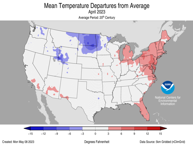

April Temperature

The contiguous U.S. average temperature during April was 51.4°F, 0.3°F above average, ranking in the middle third of the record.
Generally, temperatures were below average from the Northwest to the central Rockies and northern Plains and parts of the southern Plains. Temperatures were above average from the central Plains to the Great Lakes, along the East and Gulf coasts and in parts of the Southwest and southern Plains.
For the month of April, Maryland and Delaware each ranked second warmest on record for April while New Jersey ranked third, with nine additional states ranking among their top-10 warmest April in the 129-year record. Conversely, North Dakota ranked 10th coldest on record for the month.
The contiguous U.S. average maximum (daytime) temperature during April was 64.3°F, 0.8°F above the 20th century average, ranking in the middle third of the record. Maximum temperatures were above average from the Southwest to the Northeast, along the East and Gulf coasts and in parts of the southern Plains. Temperatures were below average from the Northwest to the central Rockies and northern Plains and parts of the southern Plains. Maryland and Delaware ranked warmest on record while New Jersey ranked third warmest with eight additional states ranking among their top-10 warmest April for daytime temperatures. North Dakota ranked eighth coldest April on record for daytime temperatures.
The contiguous U.S. average minimum (nighttime) temperature during April was 38.5°F, 0.2°F below the 20th century average, ranking in the middle third of the historical record. Minimum temperatures were above average from the Great Lakes to the Northeast, along the East and Gulf coasts and in parts of the Southwest. Temperatures were near or below normal from the Northwest to the Plains and in parts of the Tennessee River Valley. North Dakota ranked 12th coldest April on record for nighttime temperatures. Conversely, Massachusetts and Delaware ranked second and third warmest April on record, respectively, while nine additional states experienced a top-10 warmest April for nighttime temperatures.
The Alaska statewide April temperature was 16.3°F, 7.0°F below the long-term average. This ranked as the fourth-coldest April in the 99-year period of record for the state and was the coldest April since the record-cold April of 1985. Temperatures were below average across almost the entire state with near-normal temperatures in parts of the Southeast and Aleutians during the month.
Based on NOAA's Residential Energy Demand Temperature Index (REDTI), the contiguous U.S. temperature-related energy demand during April was 47 percent of average and the 22nd-lowest value in the 129-year period of record.
April Precipitation
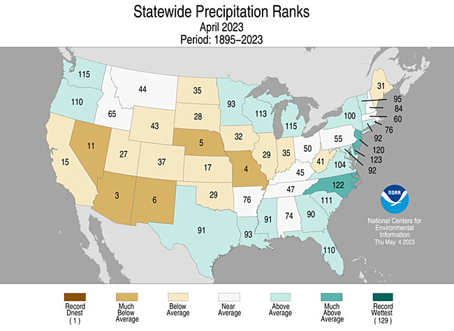
The April precipitation total for the contiguous U.S. was 2.40 inches, 0.12 inch above average, ranking in the middle third of the 129-year record.
Precipitation was above average across portions of the Northwest, along the Gulf and East coasts and Upper Midwest and below average from California to the Ohio River Valley and in parts of the northern Rockies and Maine.
Arizona, Missouri, Nebraska and New Mexico ranked third to sixth driest on record, respectively. Conversely, Delaware ranked seventh wettest, North Carolina ranked eighth wettest and New Jersey had its 10th-wettest April on record.
Monthly precipitation averaged across the state of Alaska was 2.01 inches, ranking in the middle third of the 99-year record. Conditions were wetter than average across much of the North Slope, eastern Interior and in parts of the Panhandle. Much of the central Interior to the West Coast and parts of the Southeast were near average, while parts of the Aleutians and Northwest Gulf experienced below-average precipitation for the month.
According to the May 2 U.S. Drought Monitor, about 24.4% of the contiguous U.S. was in drought, down about 3.8% from the beginning of April. Drought conditions expanded or intensified in parts of the Plains, Southeast and Northeast this month, while drought contracted or was eliminated across large parts of the West, Mid-Atlantic, Florida and in other parts of the northern and southern Plains, as well as Hawaii and Puerto Rico.
Billion-Dollar Weather and Climate Disasters
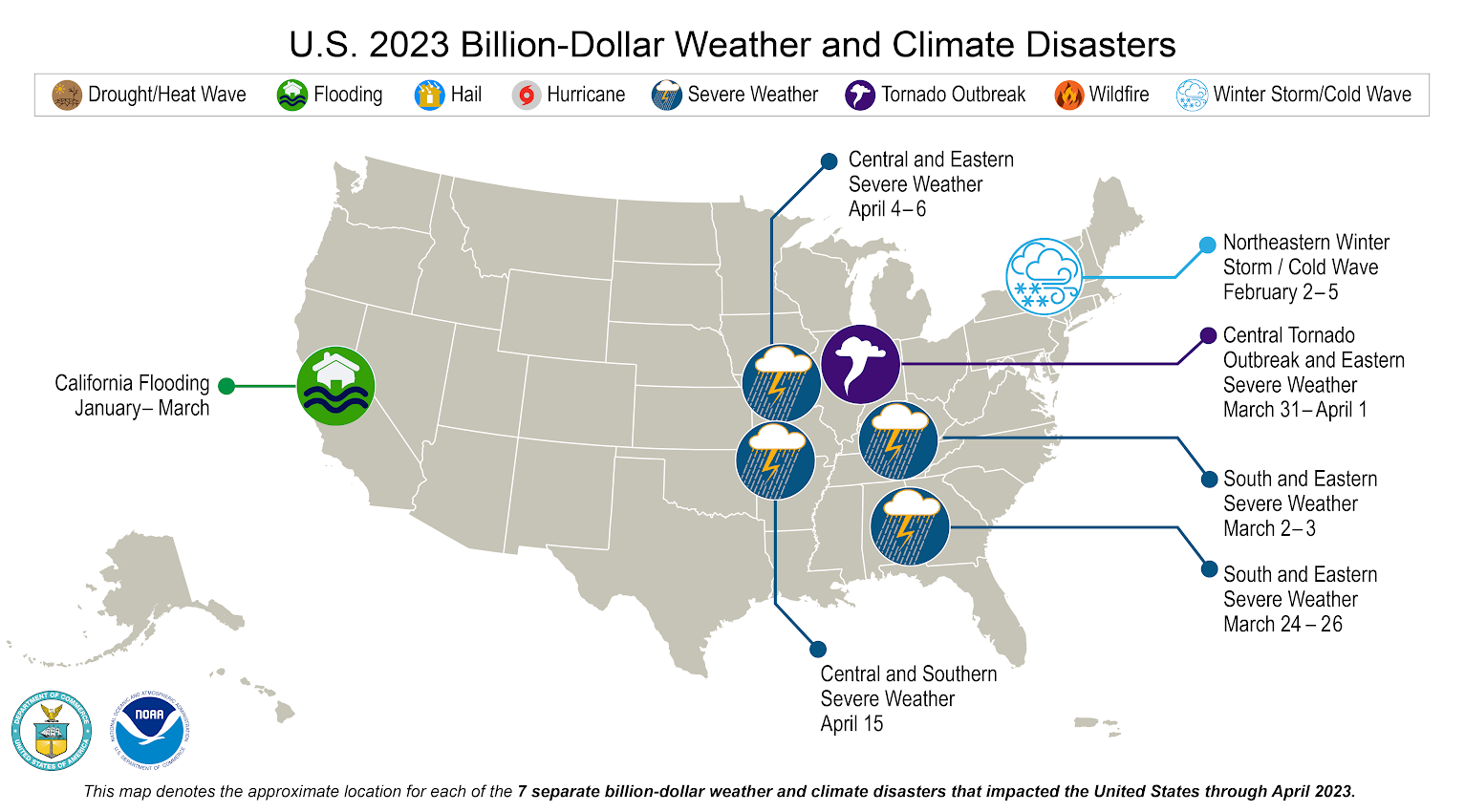
There have been seven confirmed weather and climate disaster events, each with losses exceeding $1 billion this year. These disasters consisted of five severe storm events, one winter storm and one flooding event. The total cost of these events exceeds $19 billion, and they have resulted in 97 direct and indirect fatalities. The number of disasters so far this year is the second-highest number recorded during the first four months of a year. Only 2017 and 2020 had more, with eight separate disasters recorded in January-April. The first four months of 2023 places the total, direct costs of the confirmed billion-dollar events ($19.0 billion) in second place behind the first four months of 2021 ($36.1 billion mostly driven by the historical Feb. 2021 winter storm and cold wave that crippled the Texas energy grid).
The U.S. has sustained 355 separate weather and climate disasters since 1980 where overall damages/costs reached or exceeded $1 billion (including CPI adjustment to 2023). The total cost of these 355 events exceeds $2.540 trillion.
Other Notable Events
Several notable weather systems produced severe thunderstorms and a number of tornadoes that impacted portions of the U.S. in April.
- On April 1, a 700-yard-wide EF-3 tornado touched down in Delaware, becoming the widest tornado in the state's history and tying as its strongest.
- A tornado outbreak occurred across areas of the southern and central Plains on April 19. A total of 29 tornadoes, including two EF-3 tornadoes, was confirmed by the National Weather Service, causing heavy damage and loss of life.
- On April 30, a state of emergency was declared after a rare EF-3 tornado touched down in Virginia Beach, destroying more than 100 structures.
In less than a 24-hour period, more than 25 inches of rain fell at the Fort Lauderdale Airport on April 13. The event, deemed a 1000-year event by the National Weather Service, smashed the previous one-day record of 14.59 inches of rain set on April 25, 1979.
Portions of the Upper Midwest and parts of the mountainous West received additional snowfall in April, adding to an already record- to near-record snowfall season.
- Duluth, Minnesota had its snowiest season on record with 140.1 inches of snow, besting 1995-96 by nearly 5 inches.
- Alta Ski Area in Utah surpassed 900 inches of snowfall on April 25—the most snowfall ever recorded at this ski resort.
- Jackson Hole Mountain Resort in Wyoming set a new snowfall record with 595 inches this season.
During late April, record winter snowfall across the northern Plains and Upper Midwest quickly melted due to a warm spell, causing the Mississippi River to crest and flood towns in the Upper Mississippi Valley.
According to the National Interagency Fire Center situation report released on April 28, more than 8,000 wildfires have burned more than 250,000 acres across the Southern U.S. this year. This is nearly two-thirds of all fires and acres consumed across the U.S. to date in 2023.
Year-to-Date Highlights

January-April Temperature
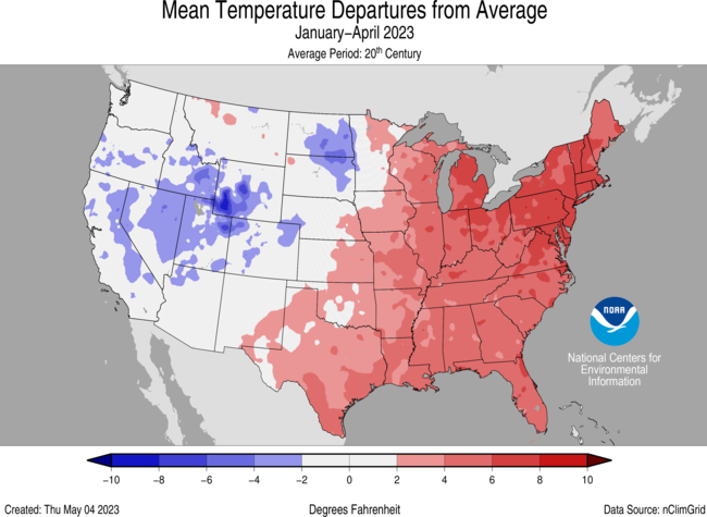
For the January-April period, the average contiguous U.S. temperature was 40.9°F, 1.8°F above average, ranking in the warmest third of the record.
Temperatures were above average across much of the eastern U.S. with near- to below-average temperatures from the northern Plains to the West Coast.
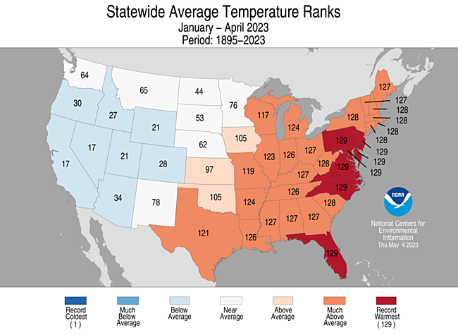
Pennsylvania, New Jersey, Maryland, Delaware, Virginia, North Carolina and Florida each had their warmest January-April period on record. New Hampshire, Massachusetts, Rhode Island, Connecticut, New York, West Virginia and South Carolina each had their second warmest, while 14 additional states ranked among their warmest 10 year-to-date periods on record. Nevada and California both ranked 17th coldest on record for this four-month period.
The contiguous U.S. average maximum (daytime) temperature during January-April was 52.0°F, 1.5°F above the 20th century average, ranking in the warmest third of the historical record. Above-average temperatures were observed across much of the eastern contiguous U.S. Near- to below-average temperatures were observed from the northern Plains to the West Coast. Pennsylvania, New Jersey, Maryland, Delaware, West Virginia, Virginia, North Carolina and Florida each ranked warmest on record for daytime temperatures during January-April period. Massachusetts, Connecticut and Rhode Island each had their second warmest, while 14 additional states ranked among their top-10 warmest January-April on record for daytime temperatures. No state experienced a top-10 coldest April on record for this four-month period.
The contiguous U.S. average minimum (nighttime) temperature during this four-month period was 29.8°F, 2.0°F above the 20th century average, ranking in the warmest third of the historical record. Above-average nighttime temperatures were observed across much of the eastern contiguous U.S., from the southern Plains to the East Coast and in parts of the northern tier. New Hampshire, Massachusetts, Connecticut, Rhode Island, New Jersey, Maryland, Delaware, North Carolina and Florida each ranked warmest on record for nighttime temperatures. Maine, Vermont, New York, Pennsylvania and Virginia each ranked second warmest with 13 additional states experiencing a top-10 warmest event for nighttime temperatures during the January-April period. Nighttime temperatures were near- to below-average from the central Rockies to the West Coast.
The Alaska January-April temperature was 11.7°F, 1.4°F above the long-term average, ranking in the middle third of the record for the state. Much of the state was near-normal for the four-month period while temperatures were above-average across much of the North Slope and in parts of the southeast and Aleutians.
Based on REDTI, the contiguous U.S. temperature-related energy demand during January-April was 32 percent of average and was the fourth-lowest value on record.
January-April Precipitation
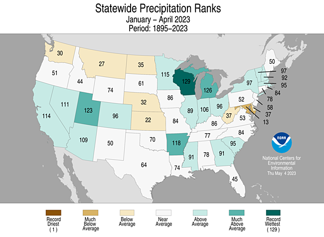
The January-April precipitation total for the contiguous U.S. was 10.22 inches, 0.74 inch above average, ranking in the wettest third of the historical record.
Precipitation was above average across much of the Southwest and Great Lakes, and in parts of the southern Mississippi Valley, Southeast and Northeast during the January-April period. Wisconsin ranked wettest on record while Michigan ranked fourth and Utah ranked seventh wettest on record, respectively.
On the dry side, precipitation was below average across parts of the Northwest, central and northern Plains, Mid-Atlantic and Florida during the January-April period. Maryland ranked 13th driest on record for this four-month period.
The January-April precipitation ranked in the wettest third of the 99-year record for Alaska, with above-average precipitation observed across much of the eastern Interior, North Slope and in parts of the Panhandle while the West Coast was much wetter than average. The central Interior and parts of the Southwest and Southeast were near average while south central Alaska and parts of the Aleutians experienced below-average precipitation during this period.
Extremes
The U.S. Climate Extremes Index (USCEI) for the year-to-date period was 32 percent above average, ranking in the highest third of the 114-year period of record. Extremes in warm maximum temperatures and warm minimum temperatures were the major contributors to this elevated CEI value. The USCEI is an index that tracks extremes (occurring in the upper or lower 10 percent of the record) in temperature, precipitation and drought across the contiguous United States.
On the regional scale, the Northeast, Ohio Valley and Southeast ranked much-above average for this year-to-date period. Each of these regions experienced elevated extremes in warm maximum temperatures and warm minimum temperatures. Conversely, extremes across the Northwest were 63 percent below average ranking as their 16th lowest year-to-date period on record.
Monthly Outlook
According to the April 30 One-Month Outlook from the Climate Prediction Center, areas from the Northwest to central Rockies, New England, Florida Peninsula and northern Alaska favor above-normal monthly mean temperatures in May, with the greatest odds likely to occur along eastern Washington to western Montana and southern Florida. The best chances for below-normal temperatures are forecast from California to southwestern New Mexico, Ohio and Tennessee River valleys and parts of the Southeast as well as across southeast Alaska. California to southern Idaho and states along the Gulf Coast, as well as parts of western Alaska, are favored to see above-normal monthly total precipitation. Below-normal precipitation is most likely to occur from the northern Plains to the Great Lakes. Drought improvement or removal is forecast across portions of the southern Plains, Mid-Atlantic and Florida, while persistence is more likely in portions of the West, the Northern to Central Plains and western Puerto Rico. Drought development is likely across the central parts of the Plains and Mississippi River Valley regions and in northwest Puerto Rico.
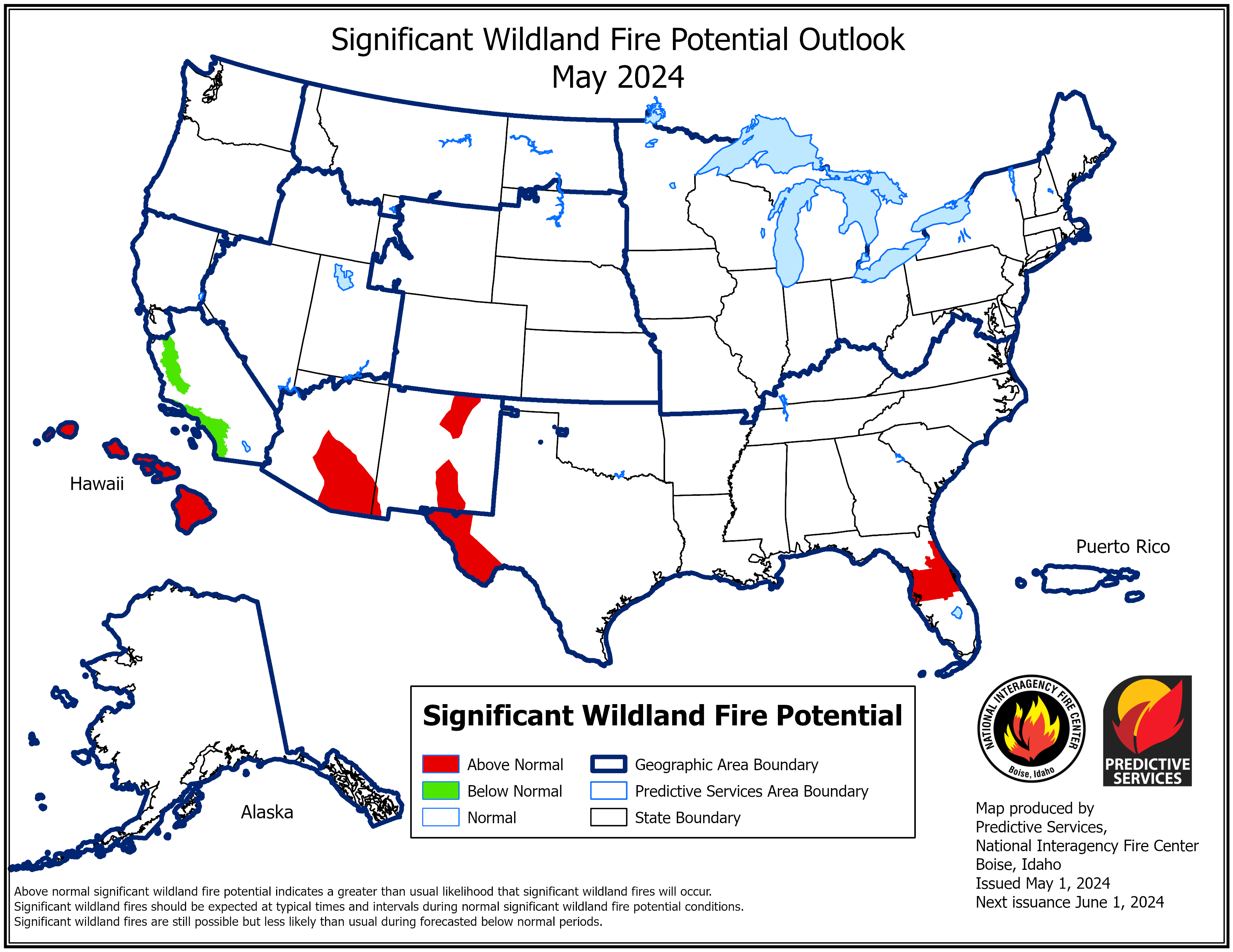
According to the One-Month Outlook issued on May 1 from the National Interagency Fire Center, portions of western Texas have above-normal significant wildland fire potential during May, while portions of the Southwest and northern Plains are expected to have below-normal potential for the month.
Regional Highlights
These regional summaries were provided by the six Regional Climate Centers and reflect conditions in their respective regions. These six regions differ spatially from the nine climatic regions of the National Centers for Environmental Information.
Northeast (Information provided by the Northeast Regional Climate Center)
A warm April started with intensifying dryness but ended with a deluge.
Temperature
The Northeast had its fifth warmest April since records began in 1895. The region's average temperature of 49.5 degrees F was 3.3 degrees F warmer than normal. April average temperatures for the 12 Northeast states ranged from 1.3 degrees F above normal in West Virginia to 4.4 degrees F above normal in Delaware. This April ranked among the 15 Aprils warmest on record for all states but West Virginia: Delaware and Maryland, second warmest; New Jersey, third warmest; Massachusetts and Pennsylvania, fourth warmest; New York and Rhode Island, fifth warmest; Connecticut, sixth warmest; New Hampshire, eighth warmest; Vermont, ninth warmest; and Maine, 15th warmest. This April was the warmest on record for Wilmington, Delaware; Newark, New Jersey; and Burlington, Vermont. Hartford, Connecticut, tied its warmest April temperature on record with a high of 96 degrees F on April 14. Worcester, Massachusetts, and Scranton and Williamsport, Pennsylvania, saw their earliest occurrence of a day with a high of at least 90 degrees F.
Precipitation
During April, the Northeast saw 3.55 inches of precipitation, 95 percent of normal. Seven of the 12 Northeast states experienced a wetter-than-normal April, with precipitation ranging from 67 percent of normal in Maine to 162 percent of normal in Delaware, its seventh wettest April. In addition, New Jersey saw its 10th wettest April. Scranton, Pennsylvania, had its wettest April day on record with 3.06 inches of rain on April 30.
Drought
The U.S. Drought Monitor from April 4 showed 2 percent of the Northeast in moderate drought and 9 percent as abnormally dry. During April, portions of the Mid-Atlantic, southeastern New York, and southern New England saw increasing precipitation deficits, below-normal streamflow, and reduced soil moisture. This led to the expansion of moderate drought and abnormal dryness across these areas. The U.S. Drought Monitor from April 25 showed 6 percent of the Northeast in moderate drought and 22 percent as abnormally dry. In addition, there was an increased risk of wildfires, with West Virginia issuing a week-long ban on all outdoor burning. The dry conditions also likely played a role in fueling a wildfire in Baltimore County, Maryland, that consumed 700 acres, the county's largest fire event since the 1970s, as well as a few large wildfires in New Jersey.
Notable Weather
On April 1, severe thunderstorms spawned 10 tornadoes in the southeastern corner of the region. The strongest of the tornadoes was an EF-3, with estimated peak wind speeds of up to 140 mph, that traveled over 14 miles across Sussex County, Delaware. It was roughly 0.4 miles wide at its largest, making it the state's widest tornado since 1950, according to the Philadelphia/Mt. Holly National Weather Service office. A few homes were swept off their foundations and collapsed, while multiple other houses and buildings such as garages and barns were damaged, some substantially. The tornado also caused significant tree damage and downed power poles including a couple of steel high-tension poles. There was one fatality, Delaware's third tornado-related death since 1950. Seven tornadoes - three EF-2s and four EF-1s - touched down in New Jersey, making it one of the state's largest tornado outbreaks since 1950. It was also likely the greatest number of tornadoes in a single day since 1950 for both Burlington and Monmouth counties in New Jersey, with an EF-2 tornado in Monmouth County among the county's strongest tornadoes on record. Pennsylvania and Maryland each saw an EF-1 tornado. In those four states, there were also multiple instances of straight-line winds, which produced similar damage to the tornadoes in some locations. Elsewhere in the Northeast, wind gusts of up to 76 mph, some related to thunderstorms and others not, downed trees and wires, snapped power poles, and damaged roofs and siding. The Northeast experienced unusually mild temperatures from April 12 to 15. High temperatures in the 70s, 80s, and 90s ranked among the 10 warmest high temperatures on record for April at multiple sites. In fact, Hartford, Connecticut, tied its warmest April temperature on record with a high of 96 degrees F on April 14. A few sites including Worcester, Massachusetts, and Scranton and Williamsport, Pennsylvania, saw their earliest occurrence of a day with a high of at least 90 degrees F. It was only the fifth April since 1892 with a 90-degree day in Worcester. On April 22, localized severe weather produced three tornadoes in the region. An EF-2 traveled nearly 10 miles across Sullivan County, New York, downing trees and causing severe damage to several farm buildings. In addition, an EF-1 tornado caused minor damage to structures and trees in Berks County, Pennsylvania, and an EF-0 tornado briefly touched down in Montgomery County, Maryland, also causing tree damage. The Northeast saw 13 tornadoes during April compared to the 1997-2021 average of four tornadoes (based on data from NOAA's Storm Prediction Center). Notably, New Jersey typically averages no tornadoes in April but saw seven this April. During the last week of April, an upper-level low pressure system stalled near the region, bringing persistent below-normal temperatures and multiple rounds of precipitation. The period from April 28 to the morning of May 1 was particularly wet, with rainfall totals ranging from 4 to 8 inches in an area from northern Maryland and Delaware through southeastern Pennsylvania and New Jersey into southeastern New York, as well as in portions of Maine. A few sites had one of their 10 wettest April days, with 3.06 inches of rain on April 30 in Scranton, Pennsylvania, becoming the site's wettest April day. In the Mid-Atlantic and southeastern New York, dry antecedent conditions somewhat tempered impacts; however, the sheer amount of rain, particularly falling on an urban setting, led to road closures, some stranded vehicles, and a few water rescues in several areas. In parts of Maine and New Hampshire, floodwaters entered buildings, swamped vehicles, and swept away chunks of roads. As the upper-level low persisted through early May, more details on the system's impacts on the Northeast, including an unusual snow event and record-low sea level pressures, will be shared in the May climate summary.
For more information, please visit the Northeast Regional Climate Center Home Page.
Midwest (Information provided by the Midwest Regional Climate Center)
Temperature
The average April temperature for the Midwest was 48.4 degrees F (9.1 degrees C), which was 0.3 degrees F (0.2 degrees C) below the 1991-2020 normal. Preliminary statewide average temperatures ranged from 4.1 degrees F (2.3 degrees C) below normal in Minnesota to 0.8 degrees F (0.4 degrees C) above normal in Ohio. April was marked by significant temperature swings across the region. Most notable was the warmup that sent temperatures soaring across the Midwest from April 8 - 16. High temperatures on April 12 and April 13 were up to 25 degrees F (13.9 degrees C) above normal across the upper Midwest, and up to 10 degrees F (5.5 degrees C) above normal in the lower Midwest. Sioux City, Iowa reached 92 degrees F (33.3 degrees C) on April 12th, which tied for the 6th highest April temperature since record-keeping began in 1896. Numerous long-running stations in Wisconsin, Minnesota, and Michigan recorded four consecutive days with temperatures at or above 80 degrees F (26.7 degrees C), setting a record for the most number days at or above 80 degrees F (26.7 degrees C) during the first half of April. A cold front traversed the region on April 16 ushering in colder-than-normal temperatures that would linger for the rest of the month. By April 17, temperatures across the northern and central Midwest were 50-60 degrees F (27.7-33.3 degrees C) cooler than at the peak warmth just 1-3 days prior. During the last week of April, minimum temperatures in the low to mid 20s were observed, even in the southernmost areas of the region, which led to frost advisories and freeze warnings. Demonstrating the extreme variability in temperatures, 1,074 daily warm temperature records and 588 daily cold temperature records were set during the month of April.
Precipitation
April precipitation totaled 3.16 inches (80 mm) for the Midwest, which was 0.51 inches (13 mm) below normal, or 86 percent of normal. Across the region, monthly precipitation anomalies were below normal in the lower Midwest and well above normal in the upper Midwest. Preliminary statewide precipitation totals ranged from 2.63 inches (67 mm) below normal in Missouri to 1.4 inches (36 mm) above normal in Wisconsin. Preliminary rankings indicate the 7th wettest April on record for Wisconsin and Michigan, and the 8th driest for Missouri. Medford, Wisconsin, accumulated 6.37 inches (161.8 mm) in April, which was the wettest April in 131 years of observations. Marquette, Michigan had its 2nd wettest April in 147 years with 6.63 inches (168.4 mm) of precipitation. Conversely, Columbia, Missouri had its 2nd driest April in 134 years with just 0.58 inches (14.7 mm) of precipitation recorded.
Drought
Just over 80 percent of the Midwest was free of drought or dryness during April, mostly east of the Mississippi River. In the west, drought and dryness persisted or expanded. Iowa continued to be the epicenter of drought in the region, with about 30 percent of the state affected by moderate (D1) to exceptional (D4) drought and about 30 percent listed as abnormally dry. Conditions worsened in Missouri, with about 11 percent of the state in drought by month's end, up 9 percent from last month. In Minnesota, dryness lingered in about 40 percent of the state while D1 affected just over 1 percent.
Snow
Snowfall totaled 5-40 inches (12.7-101.6 cm) across most of Minnesota, Wisconsin, and Michigan's Upper Peninsula during April, which was significantly above normal for these areas. High snowfall was fueled by multiple snowstorms throughout the month. There were 180 daily high snowfall records broken or tied for the month, with most happening in Minnesota and Wisconsin. Phelps, Wisconsin, located in the north central region of the state, had the snowiest April in 106 years with 34.1 inches (86.6 cm) of snow. Above-normal snowfall during April resulted in Duluth, Minnesota achieving its highest seasonal snowfall in 133 years (2022-23 snowfall was 140.1 inches (355.9 cm) as of April 30).
Notable Weather
An unusually warm early- to mid-April prompted rapid snowmelt of a deeper-than-normal snowpack in the upper Midwest. This, subsequently, led to near-record flooding along the upper Mississippi River that persisted through the end of the month. Numerous river gauges along the Mississippi River in Minnesota, Wisconsin, Iowa, and Illinois ended the month in major flood stage. Communities along the river implemented various measures including voluntary evacuations, pumping water, sand bagging, and fortifying flood walls to manage the flood waters. Boats and barge traffic were halted above St. Louis, Missouri due to flooding and lock closures along the upper stretches of the Mississippi River.
For further details on the weather and climate events in the Midwest, see the weekly and monthly reports at the Midwest Climate Watch page.
Southeast (Information provided by the Southeast Regional Climate Center)
Temperature
Mean temperatures in April were variable across the Southeast. Much of the interior of the region, as well as Puerto Rico and the U.S. Virgin Islands were near to slightly below average for the month. The greatest departures were found across parts of Alabama and Georgia, where some locations were 2 to 3 degrees F (1.1 to 1.6 degrees C) below average for the month. In contrast, mean temperatures were above average across the northern and southern ends of the region, as well as coastal sections of Georgia and the Carolinas. The greatest departures were found across the Florida Peninsula, southeastern Georgia, and northern Virginia, where many locations were between 3 and 5 degrees F (1.6 and 2.8 degrees C) above average for the month. Sarasota, FL and Brunswick, GA recorded their warmest April on record (since 1911 and 1948, respectively), Wilmington, NC and Fort Myers, FL recorded their second warmest April on record (since 1871 and 1902, respectively), Tampa, FL, Melbourne, FL, and Washington, D.C. recorded their third warmest April on record (since 1890, 1937, and 1871, respectively), Daytona Beach, FL tied its third warmest April on record (since 1923), and Miami, FL and Orlando, FL recorded their fourth warmest April on record (since 1895 and 1892, respectively). Warm weather dominated the beginning of the month, with mean temperatures between 10 and 20 degrees F (5.6 and 11.1 degrees C) above average ahead of a cold front between the 4th and 6th. Behind the front, mean temperatures were between 5 and 15 degrees F (2.8 and 8.3 degrees C) below average across much of the region, except the Florida Peninsula. Subfreezing temperatures were recorded as far south as central South Carolina and northeast Georgia on the mornings of the 10th and 11th. Warm weather returned between the 12th and 16th, with mean temperatures running 5 to 10 degrees F (2.8 to 5.6 degrees C) above average in many places. Several daily maximum temperature records were set across northern Virginia, where temperatures approached 90 degrees F (32.2 degrees C) in some places. The passage of another cold front brought slightly below average temperatures to much of the region between the 17th and 22nd, while above average temperatures continued to persist across the northern tier. Charlottesville, VA reached 92 degrees F (33.3 degrees C) on the 20th and 90 degrees F (32.2 degrees C) on the 21st. One final cold front swept across the region on the 23rd, with mean temperatures running between 5 and 15 degrees F (2.8 and 8.3 degrees C) below average, except across Florida. Morning temperatures dropped below freezing across the higher elevations of Virginia and North Carolina on the 23rd. The month ended with near average to slightly above average temperatures across most of the region.
Precipitation
Precipitation was above average across most of the region in April. Monthly totals were generally between 1 and 3 inches (25.4 and 76.2 mm) above average (125 to 150 percent of normal), with swaths of precipitation up to 6 inches (152 mm) above average (150 to 300 percent of normal) across much of the Carolinas and Virginia, as well as portions of Alabama, northern and southern Georgia, and eastern Florida. Greensboro, NC (1903-2023), Raleigh-Durham, NC (1887-2023), Greenville-Spartanburg, SC (1884-2023), and Palm Beach, FL (1888-2023) all recorded their third wettest April on record with 7.33 inches (186 mm), 7.84 inches (199 mm), 10.12 inches (257 mm), and 11.13 inches (282 mm) of precipitation, respectively. Greenville-Spartanburg, SC recorded 4.4 inches (112 mm) of precipitation on the 27th, which is the greatest one-day total for any April day on record. Rome, GA recorded its second wettest April day on record (since 1948) with 4 inches (102 mm) on the 8th of the month. Miami, FL recorded three consecutive days with at least 2 inches (50.8 mm) of precipitation from the 10th to the 12th. This is only the fourth such occurrence ever on record (since 1895). The wettest locations in the region were also found in southeastern Florida, where a slow-moving frontal boundary produced extremely heavy precipitation across eastern Broward County on the 12th and 13th of the month. Between 15 and 20 inches (381 and 508 mm) fell across an area extending from Hollywood Beach to Fort Lauderdale, with some locations recording over 30 inches (762 mm) of precipitation. A non-NOAA rain gauge at the Fort Lauderdale-Hollywood International Airport recorded 25.91 inches (658 mm) of precipitation on the 12th. If verified, this would set a new state record 24-hr precipitation amount. In contrast, the driest locations were found across northern Virginia, southern portions of Alabama, Georgia, and South Carolina, and most of Florida's Nature Coast, where monthly totals were as much as 3 inches (76.2 mm) below average (less than 75 percent of normal). Precipitation was variable across Puerto Rico, with mostly above average amounts in the eastern half of the island and below average amounts in the western half. For the second consecutive year, San Juan, PR recorded at least a trace of precipitation on every day in April. These are the only two such occurrences on record (since 1898). Precipitation was below average across the U.S. Virgin Islands. With regards to winter precipitation, trace amounts of snow and ice pellets were reported across northern Virginia on the 7th and 8th.
Drought
Cool and wet weather in April resulted in an elimination of abnormally dry (D0) conditions across parts of southern Alabama, southwest Georgia, and the western Panhandle of Florida, as well as much of the Carolinas and southern Virginia. Improvements of at least one drought category were also noted across South Florida. Moderate (D1) drought was eliminated across the eastern half of Puerto Rico but persisted across the northwest and southern slopes. Drought also persisted across the Virgin Islands, with abnormally dry (D0) conditions on Saint John, moderate (D1) drought on Saint Thomas, and severe (D2) drought on Saint Croix. Moderate (D1) drought expanded across northeast Florida, much of Virginia, and was introduced in the District of Columbia for the first time since October 2019. Severe (D2) drought persisted across much of the Florida Peninsula, with a band of extreme (D3) drought emerging from the Tampa Bay area up along the Nature Coast. Burn bans and water restrictions were noted across several counties. Overall, about 15 percent of the region was in abnormally dry (D0) conditions by the end of the month (down by about 20 percent from March), while moderate (D1) to extreme (D3) drought covered about 19 percent of the region (up by about 3 percent from March).
Agriculture
Heavy precipitation and cooler temperatures slowed or delayed many field activities, such as row crop planting and hay cutting, particularly in Alabama, Georgia, and South Carolina. In some cases, fields were completely flooded and had to be replanted. However, crops that were able to be planted early, such as corn, were already emerging in many places. The wet weather also increased disease and pest pressures in several crops, particularly strawberries. Despite the cooler and wetter weather, planting of cotton, peanuts, and soybeans were progressing well by the end of the month, except across some interior portions of the region where colder temperatures persisted. Hail damage to corn, wheat, and oat fields was reported across parts of Georgia and Florida. In southwest Georgia, most of the affected corn crop was young and is expected to recover. However, many of the wheat and oat fields were blown over, and most lost the majority of their kernels. As such, yields are expected to be reduced. Livestock and cattle were in fair to good condition across most of the region. The cool and wet weather was beneficial for recently planted pastures and forages and reduced the need for supplemental feeding in many places. However, some of the colder periods during the month resulted in frost damage to pastures and delayed dormancy breaking in Alabama, Georgia, and South Carolina. Damage was also noted to winter wheat in parts of Alabama and Georgia, resulting in stunted growth. Some blueberry, peach, and satsuma producers noted freeze damage from March that could result in losses of over 50 percent. However, later planted varieties were in generally good condition. In Florida, severe drought covered much of the citrus region, though beneficial rain did occur towards the end of the month. Pastures were in mostly poor to fair condition resulting in an increase in supplemental feed for cattle. Irrigation was being run across much of the state, while peanut and cotton planting progressed well throughout the month. In southeast Florida, heavy rain and flooding delayed sugarcane harvesting and rice planting. Warm and wet weather also increased the prevalence of whiteflies on many crops. Continued warm, dry, and windy weather resulted in low water levels across the Caribbean, with reports of dried-up farm ponds in parts of Puerto Rico. Egg production in the U.S. Virgin Islands has decreased by 50 percent due to the hot and dry conditions. Many farmers on the islands are moving to more drought-tolerant crops and those that grow quickly to help maximize production.
Notable Weather
There were 420 reports of severe weather across the Southeast in April, which is above the median frequency of 322 reports over the period 2000 to 2022 (130 percent of normal). There were 23 confirmed tornadoes (10 EF-0s, 9 EF-1s, 2 EF-2s, 2 EF-3s), which is below the median frequency of 31 (74 percent of normal). The strongest tornado was an EF-3 that touched down north of Hazel Green in Madison County, AL during the early morning of the 1st. Estimated peak winds were 160 mph (71.5 m/s). The tornado snapped and uprooted many trees and caused significant damage to numerous structures. A few homes were completely destroyed. One fatality and five injuries were confirmed. Three other weak tornadoes were reported across northern Alabama and Georgia on the 1st, resulting in at least three injuries in mobile homes. Another EF-3 tornado touched down north of the City of Virginia Beach during the early evening of the 30th. Estimated peak winds were 145 mph (64.8 m/s). Over 100 homes were damaged and several vehicles and boats were overturned. The greatest damage was found in the Chelsea neighborhood, where several homes shifted off of their foundations and roofs and upper walls were blown away. The tornado also damaged barracks and buildings at the Fort Story military base. There were 288 wind reports in April, which is above the median frequency of 197 (146 percent of normal). Thunderstorm winds exceeding 60 mph (26.8 m/s) were reported across parts of Alabama and Virginia between the 1st and 3rd of the month. Grandfather Mountain in western North Carolina recorded a 76 mph (33.9 m/s) wind gust on the 2nd. Wet and windy conditions caused two large pine trees to fall near the tee box on the 17th hole of the Augusta National Golf Club in Georgia during the playing of the Masters on the 7th of the month. No injuries were reported. Straight-line winds exceeding 50 mph (22.4 m/s) were recorded across parts of southern Alabama and northwest Florida on the 12th of the month. An 11-year-old girl was injured when a tree fell on her house in Santa Rosa County, FL. Two other individuals were injured when their camper rolled over in Gulf State Park in Baldwin County, AL. On the 22nd, a man was injured after being pinned under tree limbs that had fallen during a thunderstorm in Dillon, SC. Several reports of thunderstorm winds exceeding 50 mph (22.4 m/s) were recorded across parts of southern Georgia and northern Florida on the 27th of the month. A few gusts in the Tampa area exceeded 60 mph (26.8 m/s), while 80 mph (35.8 m/s) gusts were recorded around Tallahassee. One person in Leon County was injured when a tree fell on their car. There were 108 hail reports in April, which is above the median frequency of 94 (115 percent of normal). Over a dozen of these reports were for very large hail (at least 2 inches or 50.8 mm), many of which were in Florida. The largest hailstone was teacup-sized, or 3 inches (76.2 mm), in the community of Antioch in west-central Florida on the 24th of the month. Baseball-sized hail (2.75 inches or 69.8 mm) was also reported to the northeast in Lake County, FL on the 25th. On the 5th of the month, nickel-sized hail (0.88 inches or 22.3 mm) was reported in the town of Lajas on the southwestern slopes of Puerto Rico. This marks the sixth largest hailstone recorded in Puerto Rico since 1955 (the largest is 1.75 inches or 44.4 mm). In addition, pea-sized hail (0.25 inches or 6.3 mm) was reported in the community of Aguada on the extreme western interior of the island. Pea-sized hail was also reported in Frederiksted on the island of Saint Croix on the 6th of the month. This marks only the second time since 1955 that hail has been reported in the U.S. Virgin Islands. Atlanta, GA recorded a daily pollen concentration of 3417 grains per cubic meter on the 20th of the month, which marks the highest value to date in the season since records began in 1992. Significant flooding was observed with the heavy rainfall event in southeast Florida on the 12th and 13th. Several locations in the Fort Lauderdale, Hollywood, and Dania Beach areas were under 1 to 3 feet (305 to 914 mm) of water, stranding many people in their homes. Flooding at the Fort Lauderdale-Hollywood International Airport forced the cancellation of hundreds of flights over a two-day period. Broward County schools also closed for the remainder of the week due to flooded buildings and impassable roads. There were four rip current fatalities in April. On the 4th of the month, a 50-year-old male drowned near La Concha Beach in Puerto Rico. A 21-year-old male drowned near Saint Augustine Beach, FL on the 6th of the month. A father and daughter drowned after being caught in a rip current at Pass-a-Grille beach near Saint Petersburg, FL on the 23rd of the month. There was one lightning fatality in April. A 39-year-old male was struck while boating in Brevard County, FL on the 16th of the month.
For more information, please visit the Southeast Regional Climate Center Home Page.
High Plains (Information provided by the High Plains Regional Climate Center)
The northern parts of the High Plains continued to deal with the brutal winter, while the southern portions were dry once again. Both parts of the region are dealing with issues related to their ends of the extremes. Snow continued to pile up in the Dakotas and Wyoming, with numerous impacts. Hunting permits for antelope and deer were slashed in Wyoming this fall as a result of the winter. The Wyoming Game and Fish Department observed the excessive snowfall reduced both populations and has cut the permit numbers in an effort to help manage the populace. In North Dakota, a large number of dead deer were reported around the state, with over 100 reported in the Jamestown area alone. The rapid snowmelt in the middle of the month further exacerbated the issues, with flooding along the Red River and the Big Sioux. While in South Dakota, the heavy snow caused homes to explode due to the excessive weight. In the southern Plains, drought-related issues continued to plague the population. Several significant wildfires broke out in Nebraska due to the dry conditions. The state has implemented a burn ban to help reduce the number of fires. Kansas agricultural producers are preparing for another year of drought, with farmers scrambling to find food sources for their already culled herds.
Temperature
Winter does not seem to want to end, with cooler temperatures dominating the northern and western parts of the region. Average temperatures were still below freezing across North Dakota and Wyoming, with some locations recording their coldest April on record. Temperatures have been cooler for western Wyoming since the beginning of the year, with some locations 10 degrees F (5.6 degrees C) below normal through the end of April. Multiple locations including Tower Falls and Pavillion recorded their coldest month on record. Old Faithful in Yellowstone National Park observed a chilly average temperature of 25.9 degrees F (-3.4 degrees C) this month. Just like Wyoming, North Dakota continued to be cooler into April. Despite having temperatures over 10 degrees F (5.6 degrees C) below normal, only three locations in the state ranked as the coldest April on record. Most notably, the town of Mayville has records dating to 1895 and observed an average temperature of 29.8 degrees F (-1.2 degrees C) to rank coldest on record. Both Moffit and Carrington also recorded their coldest month. A heatwave impacted the lower part of the region in the middle of April, leading to temperatures skyrocketing well above 90 degrees F (32.2 degrees C). Atwood, Kansas was the warmest, with a high of 97 degrees F (36.1 degrees C) on the 13th. Hundreds of daily temperature records were broken from the 11th to the 13th as a result of this early heatwave.
Precipitation
April precipitation was below-normal for much of the region, with Nebraska very dry. The majority of the state was below 25 percent of their normal precipitation, leading to multiple locations ranking in the top 10 driest. Southwestern Kansas finally received some meaningful precipitation, however, not nearly enough to help improve the dire drought situation. North Platte, Nebraska was arguably the driest location in the region, with only 0.04 inches (1.02 mm) of precipitation. This tied with 1928 for the driest April on record. Nearby Grand Island only observed 0.15 inches (3.81 mm), ranking 3rd driest. Other locations in the state ranking in the top 10 driest include Chadron, Lincoln, and Norfolk. The significant snowfall that has impacted the Dakotas and Wyoming continued into April. Parts of Wyoming saw over 30 inches (76.2 cm) of snow, leading to numerous records. The small town of Atlantic City observed a whopping 48.8 inches (123.95 cm), the most in the state. The Dakotas received over 20 inches (50.8 cm) in some places. With such high totals continuing into April, many locations are likely to have recorded their snowiest year on record.
Drought
For the second month in a row, drought conditions improved in the Dakotas while degrading in the southern plains. Central Kansas and the front range of Colorado experienced up to a three-class degradation in April alone. Overall, there was a 6 percent decrease in D0 to D4 (abnormally dry to exceptional drought conditions). Rapid snowmelt after well-above-normal temperatures caused North Dakota to observe a 40 percent decrease in D0 to D4. Soil moisture greatly improved, while some minor flooding is taking place in the state. While some beneficial precipitation occurred in southwestern Kansas late in the month, the majority of the state has experienced a poor spring for precipitation. The central part of the state observed a multi-class degradation, with a 10 percent increase in D4. Elsewhere in the region, other localized improvements and degradation were observed.
For more information, please visit the High Plains Regional Climate Center Home Page.
South (Information provided by the Southern Regional Climate Center)
Tornadoes in the Southern Region led to 33 injuries and 11 fatalities during April.
Temperature
Temperatures were near to slightly below normal for much of the Southern Region for the month of April. April started off warm with temperatures during the first two weeks averaging two to three degrees F above normal. A pattern change in mid-April contributed to temperatures of two to four degrees F below normal across much of the region during the last two weeks of April. All six states in the Southern Region were near their historical median values (out of 129 years) during April. The warmest recorded temperature in the region was 105 F at Falcon Lake, Texas on April 15th. The coldest recorded temperature in the region was 20 F at Mt. Leconte, Tennessee on April 25th and at Lipscomb, Texas on April 5th. No station set record high or low temperatures for April in the Southern Region. Two long-term stations set records for highest recorded minimum temperature during April: Pikeville, Tennessee (68 F) on April 5th and Harlingen, Texas (79 F) on April 21st.
Precipitation
Precipitation was below normal for the western and northern portions of the region and well above normal along the Gulf Coast in Texas and Louisiana, much of eastern Texas, southern Arkansas, and northwestern Louisiana. Statewide average totals were above normal for Louisiana (37th wettest), Mississippi (40th wettest), Texas (42nd wettest), and the Southern Region as a whole (49th wettest). Oklahoma (29th driest) and Tennessee (45th driest) were drier than the 1991-2020 normal for April. Arkansas was near its median historical value. The five wettest stations for April were 5 CoCoRaHS sites, all in Texas: near Hallettsville (13.21 inches), near Lufkin (13.16 inches), Huntsville 1.3 SSE (13.09 inches), Huntsville 4.7 S (13.09 inches), and near Benwheeler (13.07 inches). Four stations reported single daily rainfall accumulations of over six inches and were spread across two states: near Lakes Charles, Louisiana (9.37 inches, April 7th), near Laredo, Texas (8.21 inches, April 23rd), near Crowley, Louisiana (6.85 inches, April 7th), and near Gonzales, Texas (6.43 inches, April 7th). One long-term station recorded a daily rainfall accumulation record for the month of April: Fedor 3 SE, Texas (3.96 inches, April 7th).
Drought/Flooding
During April the spatial extent of drought conditions remained relatively stable across the Southern Region, with improvements largely limited to eastern and deep south Texas. The percentage of the region experiencing moderate drought (D1) or worse decreased from 41.88 percent on April 4th to 34.98 percent on May 2nd. As of May 2nd much of central and western Texas, the Texas Panhandle, and western Oklahoma remained in drought conditions, with much of it being extreme (D3) or exceptional (D4). Moderate drought conditions persisted along the southeast Louisiana coast. Degradation was common in the Texas Panhandle and western Oklahoma during April. In the areas experiencing drought the primary impacts are low reservoir levels, low streamflow, and poor conditions of pasture and crops. As of April 30th, 61 percent of the winter wheat in Oklahoma and 57 percent of winter wheat in Texas was rated as Poor to Very Poor condition. Higher water levels and flows in areas north of the region have contributed to improvements in water levels at gauges along the lower Mississippi River, though levels remained below their historical mean levels for this time of year.
Notable Weather
Forty tornadoes were reported across the Southern Region in April, impacting all six states in the region. The ratings were 11 EF0, 16 EF1, 10 EF2, 2 EF3, and 1 not rated. In total there were 33 reported injuries and 11 fatalities. On April 1st, a long-lived EF3 tornado in McNary County, Tennessee injured 23 and led to nine fatalities. On April 1st, an EF3 tornado in Tipton County, Tennessee led to five injuries and one fatality. On April 1st, an EF2 tornado in Pontotoc, Mississippi injured one. On April 1st, an EF2 tornado in Rutherford, Tennessee led to two injuries. On April 19th, an EF3 tornado in Cole, Oklahoma led to one fatality. An EF1 tornado in Coryell County, Texas on April 28th injured two. There were a total of 266 severe wind reports, including a report of 90 MPH winds near McAdoo, Texas on April 26th. The largest of 486 hail reports were 4.5 inch hail reported at Dickens, Texas and near Bellmead, Texas on April 26th. Ongoing dry conditions and high winds led to wildfires occurring in Texas and Oklahoma during April, resulting in evacuations, road closures, and damage to structures though overall fire activity has been near normal.
For more information, please visit the Southern Regional Climate Center Home Page.
West (Information provided by the Western Region Climate Center)
Colder and drier than normal conditions persisted across the western U.S. during April 2023 as weak high pressure persisted offshore driving the stormtrack northwards. This brought generally dry and zonal flow to the western states and welcome precipitation to coastal Oregon and Washington. Snowmelt began in earnest throughout much of the western U.S. with the dry and sunny conditions. The coldest temperatures occurred in southwestern Wyoming, far northwestern Utah, and southeastern Idaho. Colder than normal conditions in Alaska limited melt rates of the record snowpack. Temperatures and precipitation in Hawaii were near-normal to above normal.
Temperature
Much of the western U.S. experienced near-to-below normal temperatures during April. Pine View Dam, Utah observed its coldest April in 80 years of record keeping with a mean temperature of 35.8 degrees Fahrenheit (7.1 degrees Fahrenheit below normal). Green River, Wyoming tied its 3rd coldest April since observations began 106 years ago with a mean temperature of 36.1 degrees Fahrenheit (6.8 degrees Fahrenheit below normal). Warmer than normal conditions were observed in western Arizona, southern Nevada, and parts of California.
Precipitation
Aside from western Oregon and Washington, the western U.S was drier than normal during April. In 99 years of record keeping, Northport, Washington observed its wettest April, with 3.17 inches of rainfall (1.5 inches above normal). Many locations with long-term observations in central and southern California, the southern half of Nevada and throughout Arizona and New Mexico recorded a record dry April. Zero precipitation was commonly observed in these places.
Snowpack
Snowpack conditions at the end of April remains well above normal (>150 percent of normal) across the southern tier of the western U.S. and the western Cascades in the northern tier. Further inland in the northern tier, near to slightly below normal conditions are found. Sunny conditions and several warm spells with high daytime temperatures and above-freezing nighttime temperatures spurred rapid snowmelt in Utah, California and Nevada. Melt out has occurred in the lower elevation areas of Arizona and New Mexico, however high elevations continue to maintain an impressive snowpack. The lowest snowpacks (< 50% of normal) are found in northwestern Montana and northwestern Wyoming. Maritime and intermountain snowpacks have achieved the ready-to-melt “ripe” state (approximately 50% density) while some higher elevation continental snowpacks, which typically ripen during May, remain at lower densities (30-40%).
Drought
While all western states still have some level of drought, the cool, wet, and snowy winter of water year 2023 led to dramatic short-term drought improvements in many locations. Compared to the start of the water year when less than 4% of the west had no drought, as of May 2, 46% of the west is drought free. The remaining areas of extreme to exceptional drought, accounting for less than 1.25% of the west, are found in far northeastern New Mexico, southeastern Wyoming, and central Oregon.
Alaska Summary
April brought historic cold to the northern two thirds of Alaska, limiting melting of the record snowpack built throughout a wet and snowy winter. Nome tied its all-time April record low of -30 degrees Fahrenheit on April 8. In the central interior, Tanana tied its second-coldest April in 105 years of record keeping with a mean temperature of 14.4 degrees Fahrenheit (12.9 degrees Fahrenheit below normal). With zero measured precipitation, Tanana also tied its driest April on record (0.3 inches below normal). With 0.91 inches of precipitation, Gulcana observed its 2nd wettest April in 83 years of records (0.7 inches above normal). Cold conditions limited sea ice melt over the northern Bering Sea region. Sea ice extent was typical of the 1991-2020 median.
Hawaii Summary
April 2023 brought near normal to above normal precipitation and both warmer than normal and close to normal temperatures to Hawaii. Drought conditions are limited to the far northern coast of the Island of Hawaii where a small area of moderate drought exists. Lihui, on Kauai, observed its tenth wettest April in 73 years of records with 4.79 inches of rainfall (2.8 inches above normal). On Molokai, Hilo measured 3.9 inches of rainfall (2.4 inches above normal), making April its 9th wettest since records began 74 years ago. Molokai also experienced its fifth warmest April on record with a mean temperature of 74.9 degrees Fahrenheit (0.8 degrees Fahrenheit above normal). Sea surface temperatures were slightly warmer than normal (1-2 degrees Fahrenheit) to the west of, and in the immediate vicinity of, Hawaii as La Niña weakens.
Notable Weather
Snowmelt Runoff Lowers Salinity in the Great Salt Lake: The historic snowpack built throughout Utah, but especially the Wasatch, began to melt in earnest during April. Snowmelt runoff flowing into the Great Salt Lake caused the lake to rise multiple feet with further rises expected. This is excellent news from lake chemistry and ecological perspectives as freshwater input to the south arm is now spilling into the hypersaline northern half. The freshwater is lowering lake salinity and helping stave off ecological collapse triggered by reduction of the lake's keystone species, the brine shrimp. Flooding from snowmelt runoff brought issues to California and Nevada as well, especially in the Tulare Lake Basin of California's San Joaquin Valley.
For more information, please go to the Western Regional Climate Center Home Page.