NOAA Monthly U.S. Climate Divisional Database (NClimDiv)
NClimDiv (Climate Indices)
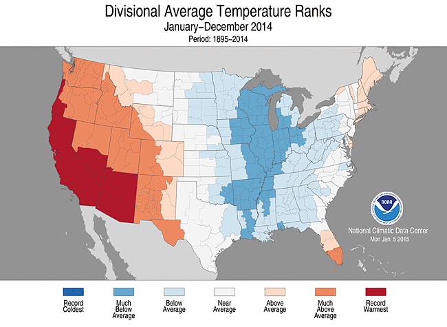 Divisional Average Temperature Ranks, January-December 2014
This dataset replaces the previous Time Bias Corrected Divisional Temperature-Precipitation Drought Index. The new divisional data set (NClimDiv) is based on the Global Historical Climatological Network-Daily (GHCN-D) and makes use of several improvements to the previous data set. For the input data, improvements include additional station networks, quality assurance reviews and temperature bias adjustments. Perhaps the most extensive improvement is to the computational approach, which now employs climatologically aided interpolation. This 5km grid based calculation nCLIMGRID helps to address topographic and network variability. This data set is primarily used by the National Oceanic and Atmospheric Administration (NOAA) National Climatic Data Center (NCDC) to issue State of the Climate Reports on a monthly basis. These reports summarize recent temperature and precipitation conditions and long-term trends at a variety of spatial scales, the smallest being the climate division level. Data at the climate division level are aggregated to compute statewide, regional and national snapshots of climate conditions. For CONUS, the period of record is from 1895-present. Derived quantities such as Standardized precipitation Index (SPI), Palmer Drought Indices (PDSI, PHDI, PMDI, and ZNDX) and degree days are also available for the CONUS sites.
In March 2015, data for thirteen Alaskan climate divisions were added to the NClimDiv data set. Data for the new Alaskan climate divisions begin in 1925 through the present and are included in all monthly updates. Alaskan climate data include the following elements for divisional and statewide coverage: average temperature, maximum temperature (highs), minimum temperature (lows), and precipitation. The Alaska NClimDiv data were created and updated using similar methodology as that for the CONUS, but with a different approach to establishing the underlying climatology. The Alaska data are built upon the 1971-2000 PRISM averages whereas the CONUS values utilize a base climatology derived from the NClimGrid data set.
As of November 2018, NClimDiv includes county data and additional inventory files.
- Cite as: Vose, Russell S.; Applequist, Scott; Squires, Mike; Durre, Imke; Menne, Matthew J.; Williams, Claude N., Jr.; Fenimore, Chris; Gleason, Karin; Arndt, Derek (2014): NOAA Monthly U.S. Climate Divisional Database (NClimDiv). [indicate subset used]. NOAA National Climatic Data Center. doi:10.7289/V5M32STR [access date].
- doi:10.7289/V5M32STR
- NCEI DSI 9640_02
- gov.noaa.ncdc:C00005
C00005
| Search Data |
|
| Download Data |
|
| Distribution Formats |
|
| Ordering Instructions | Contact NCEI for other distribution options and instructions. |
| Distributor | NOAA National Centers for Environmental Information
ncei.info@noaa.gov |
| Dataset Point of Contact | Customer Engagement Branch
NOAA National Centers for Environmental Information 1-828-271-4800 ncei.orders@noaa.gov |
| Dataset Point of Contact | Climate Monitoring Branch
DOC/NOAA/NESDIS/NCEI > National Centers for Environmental Information, NESDIS, NOAA, U.S. Department of Commerce +1 828-271-4800 ncei.monitoring.info@noaa.gov |
| Time Period | 1895-01-01 to Present (time interval: 1-month) |
| Spatial Bounding Box Coordinates |
N: 71.5
S: 24.0
E: -66.0
W: -180.0
|
| Spatial Coverage Map | |
| General Documentation |
|
| Associated Resources |
|
| Publication Dates |
|
| Data Presentation Form | Digital table - digital representation of facts or figures systematically displayed, especially in columns
|
| Dataset Progress Status | Ongoing - data is continually being updated |
| Data Update Frequency | Monthly |
| Purpose | The U.S. Climate Divisional Dataset is the only long-term temporally and spatially complete dataset from 1895 to the present for the Contiguous United States (CONUS) from NCEI. The dataset provides temperature, precipitation and drought indices, as well as heating and cooling degree days. Coverage is provided for U.S. climate divisions, states, multi-state regions, and the nation. Text output, and static and interactive graphs are available. |
| Use Limitations |
|
| Dataset Citation |
|
| Cited Authors |
|
| Principal Investigators |
|
| Collaborators |
|
| Publishers |
|
| Theme keywords | Global Change Master Directory (GCMD) Science Keywords
|
| Data Center keywords | Global Change Master Directory (GCMD) Data Center Keywords
|
| Platform keywords | Global Change Master Directory (GCMD) Platform Keywords
|
| Instrument keywords | Global Change Master Directory (GCMD) Instrument Keywords
|
| Place keywords | Global Change Master Directory (GCMD) Location Keywords
|
| Data Resolution keywords | Global Change Master Directory (GCMD) Temporal Data Resolution Keywords
|
| Use Constraints |
|
| Access Constraints |
|
| Fees |
|
| Lineage Statement | This dataset exhibits substantial differences with the previous Climate Divisional Dataset over the period 1895-2013. The first improvement is to the input data, which now include additional station records and contemporary bias adjustments (Menne and Williams, 2009). The second improvement is to the suite of climatic elements, which has been expanded to include both maximum and minimum temperature. The final (and far most extensive) improvement is to the computational methodology, which now addresses topographic and network variability via climatologically aided interpolation (Willmott and Robeson, 1995). |
| Processor |
|
| Processing Steps |
|
| Source Datasets |
|
| Processing Steps |
|
Last Modified: 2023-06-23
For questions about the information on this page, please email: ncei.info@noaa.gov