NOAA JPSS Visible Infrared Imaging Radiometer Suite (VIIRS) Cloud Type and Phase Environmental Data Record (EDR) from NDE
JPSS-CLP-NDE
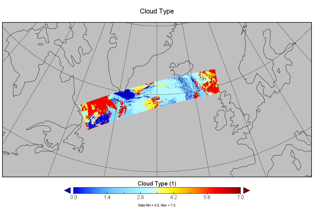 Example of Suomi NPP VIIRS NDE Cloud Type over the northern Atlantic Ocean on July 06, 2017.
This dataset contains a high quality operational Environmental Data Record (EDR) of cloud type and phase from the Visible Infrared Imaging Radiometer Suite (VIIRS) instrument onboard the Suomi-NPP satellite and is produced by the NOAA Satellite and Information Service (NESDIS). The EDR contains cloud type and phase information (liquid water, supercooled water, mixed phase, optically thin ice, optically thick ice, and multilayered ice) for each cloudy pixel. Additionally, this product includes data quality information that provides an assessment of the cloud phase values for on-earth pixels. The algorithm uses VIIRS infrared bands M14 (8.5µm), M15 (11.2µm), and M16 (12.3µm). The spatial resolution of the EDR is 750 meters and data are collected during day and night passes which provides global coverage at a temporal resolution of approximately every 12 hours. VIIRS cloud phase data distributed by the NESDIS Data Exploitation (NDE) system and obtained from the Comprehensive Large Array-Data Stewardship System (CLASS) are distributed in single 86-second granules in NetCDF-4 format with metadata attributes included.
- Cite as: Heidinger, Andrew, Donahue, David, and NOAA JPSS Program Office (2017): NOAA JPSS Visible Infrared Imaging Radiometer Suite (VIIRS) Cloud Type and Phase Environmental Data Record (EDR) from NDE. [indicate subset used]. NOAA National Centers for Environmental Information. [access date].
- gov.noaa.ncdc:C01433
- gov.noaa.class:JPSS_GRAN
C01433
| Download Data |
|
| Order Data |
|
| Distribution Formats |
|
| Ordering Instructions | Contact NCEI for other distribution options and instructions. |
| Distributor | NOAA National Centers for Environmental Information
ncei.info@noaa.gov |
| Dataset Point of Contact | Customer Engagement Branch
NOAA National Centers for Environmental Information 1-828-271-4800 ncei.orders@noaa.gov |
| Time Period | 2017-07-06 to Present (time interval: 12-hour) |
| Spatial Reference System | urn:ogc:def:crs:EPSG::4326 |
| Spatial Bounding Box Coordinates |
N: 90.0
S: -90.0
E: 180.0
W: -180.0
|
| Spatial Coverage Map | |
| General Documentation |
|
| Processing Documents |
|
| Associated Resources |
|
| Publication Dates |
|
| Edition | Validated |
| Data Presentation Form | Digital image
|
| Dataset Progress Status | Ongoing - data is continually being updated |
| Data Update Frequency | Continual |
| Purpose | This EDR is used downstream for other cloud algorithms (cloud height and optical properties) and could be used for the following applications: aircraft icing, precipitation type, and cloud microphysical studies. |
| Use Limitations |
|
| Dataset Citation |
|
| Cited Authors |
|
| Principal Investigators |
|
| Resource Providers |
|
| Publishers |
|
| Theme keywords | Global Change Master Directory (GCMD) Science Keywords
|
| Data Center keywords | Global Change Master Directory (GCMD) Data Center Keywords
|
| Platform keywords | Global Change Master Directory (GCMD) Platform Keywords
|
| Instrument keywords | Global Change Master Directory (GCMD) Instrument Keywords
|
| Place keywords | Global Change Master Directory (GCMD) Location Keywords
|
| Project keywords | Global Change Master Directory (GCMD) Project Keywords
|
| Data Resolution keywords | Global Change Master Directory (GCMD) Horizontal Data Resolution Keywords
|
| Stratum keywords | Global Change Master Directory (GCMD) Location Keywords
|
| Use Constraints |
|
| Access Constraints |
|
| Fees |
|
| Lineage Statement | The data were produced by the NOAA Office of Satellite and Product Operations (OSPO) NDE/PDA and are archived at the NOAA National Centers for Environmental Information (NCEI). |
| Processor |
|
| Processing Steps |
|
| Processing Documents |
|
| Source Datasets |
|
| Processing Steps |
|
Last Modified: 2023-06-23
For questions about the information on this page, please email: ncei.info@noaa.gov