NOAA Climate Data Record (CDR) of AVHRR Normalized Difference Vegetation Index (NDVI), Version 5

Normalized Difference Vegetation Index

browse graphic
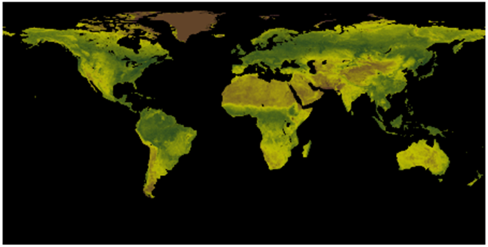
Global image of daily AVHRR NDVI.
This dataset contains gridded daily Normalized Difference Vegetation Index (NDVI) derived from the NOAA Climate Data Record (CDR) of Advanced Very High Resolution Radiometer (AVHRR) Surface Reflectance. The data record spans from 1981 to 10 days before the present using data from eight NOAA polar orbiting satellites: NOAA-7, -9, -11, -14, -16, -17, -18 and -19. The data are projected on a 0.05 degree x 0.05 degree global grid. This dataset is one of the Land Surface CDR Version 5 products produced by the NASA Goddard Space Flight Center (GSFC) and the University of Maryland (UMD). Improvements for Version 5 include using the improved surface reflectance data, correcting the data for known errors in time, latitude, and longitude variables, as well as improvements in the global and variable attribute definitions. The dataset is in the netCDF-4 file format following ACDD and CF Conventions. The dataset is accompanied by algorithm documentation, data flow diagram and source code for the NOAA CDR Program.
  • Cite as: Vermote, Eric; NOAA CDR Program. (2019): NOAA Climate Data Record (CDR) of AVHRR Normalized Difference Vegetation Index (NDVI), Version 5. [indicate subset used]. NOAA National Centers for Environmental Information. https://doi.org/10.7289/V5ZG6QH9. Accessed [date].
Download Data
Distribution Formats
  • NetCDF (Version: 4)
    • File Specification: The NetCDF data files comply with the Climate and Forecast (CF) Metadata Conventions and the NetCDF Attribute Convention for Dataset Discovery (ACDD).
Ordering InstructionsContact NCEI for other distribution options and instructions.
DistributorNOAA National Centers for Environmental Information
ncei.info@noaa.gov
Dataset Point of Contact NOAA Climate Data Record Program Office
DOC/NOAA/NESDIS/NCEI > National Centers for Environmental Information, NESDIS, NOAA, U.S. Department of Commerce
1-828-271-4800
land_sfc_bundle_contacts@noaa.gov
Time Period1981-06-24 to Present (time interval: 1-day)
Spatial Bounding Box Coordinates
N: 90.0
S: -90.0
E: 180.0
W: -180.0
Spatial Coverage Map
General Documentation
Processing Documents
  • AVHRR Normalized Difference Vegetation Index Source Code
    • CDR Source Code (download)
      This source code is for reference only. The source code is provided to maintain transparency of the algorithm and processes used in creating the Climate Data Record (CDR). The source code is not intended to be portable to any computer system(s) beyond that of the original CDR producer's environment.
  • Flowcharts Vegetation CDR
  • Climate Algorithm Theoretical Basis Document (C-ATBD)
Associated Resources
Publication Dates
  • publication: 2019-07-11
EditionVersion 5
Data Presentation Form Digital image
Dataset Progress StatusOngoing - data is continually being updated
Data Update Frequency Daily
PurposeThis dataset was produced to provide a high quality Climate Data Record (CDR) of Normalized Differential Vegetation Index (NDVI) for detecting drought-stressed regions, forecasting agricultural yields, and forestry and crop management. The NDVI CDR summarizes the measurement of surface vegetation coverage activity. The surface reflectance calculations in the red and the near infrared spectral bands derived from Advanced Very High Resolution Radiometer (AVHRR) provide NDVI values. The NDVI CDR produces daily output on a 0.05 degree by 0.05 degree global grid, from 1981 to present. This consistent, long-term record of remotely sensed vegetation observations allows scientists to characterize the health of vegetation in different regions across the world.
Use Limitations
  • See the Algorithm Theoretical Basis Document (ATBD) for a description of this dataset's use limitations.
Dataset Citation
  • Cite as: Vermote, Eric; NOAA CDR Program. (2019): NOAA Climate Data Record (CDR) of AVHRR Normalized Difference Vegetation Index (NDVI), Version 5. [indicate subset used]. NOAA National Centers for Environmental Information. https://doi.org/10.7289/V5ZG6QH9. Accessed [date].
Cited Authors
  • Vermote, Eric
    NASA Goddard Space Flight Center
  • NOAA CDR Program
Principal Investigators
Collaborators
  • NOAA CDR Program
Publishers
  • NOAA National Centers for Environmental Information
Theme keywordsGlobal Change Master Directory (GCMD) Science Keywords
  • Earth Science > Biosphere > Vegetation > Vegetation Index > Normalized Difference Vegetation Index (ndvi)
Data Center keywordsGlobal Change Master Directory (GCMD) Data Center Keywords
  • DOC/NOAA/NESDIS/NCEI > National Centers for Environmental Information, NESDIS, NOAA, U.S. Department of Commerce
  • DOC/NOAA/NESDIS/NCDC > National Climatic Data Center, NESDIS, NOAA, U.S. Department of Commerce
  • NASA/GSFC > Goddard Space Flight Center, NASA
  • UMD > University of Maryland
Platform keywordsGlobal Change Master Directory (GCMD) Platform Keywords
  • NOAA-7 > National Oceanic & Atmospheric Administration-7
  • NOAA-9 > National Oceanic & Atmospheric Administration-9
  • NOAA-11 > National Oceanic & Atmospheric Administration-11
  • NOAA-14 > National Oceanic & Atmospheric Administration-14
  • NOAA-16 > National Oceanic & Atmospheric Administration-16
  • NOAA-17 > National Oceanic & Atmospheric Administration-17
  • NOAA-18 > National Oceanic & Atmospheric Administration-18
  • NOAA-19 > National Oceanic & Atmospheric Administration-19
Instrument keywordsGlobal Change Master Directory (GCMD) Instrument Keywords
  • AVHRR > Advanced Very High Resolution Radiometer
Place keywordsGlobal Change Master Directory (GCMD) Location Keywords
  • Geographic Region > Global Land
Project keywordsGlobal Change Master Directory (GCMD) Project Keywords
  • NOAA Climate Data Record (CDR) Program
  • NOAA OneStop Project
Use Constraints
  • Cite as: Vermote, Eric; NOAA CDR Program. (2019): NOAA Climate Data Record (CDR) of AVHRR Normalized Difference Vegetation Index (NDVI), Version 5. [indicate subset used]. NOAA National Centers for Environmental Information. https://doi.org/10.7289/V5ZG6QH9. Accessed [date].
  • See the Use Agreement for this dataset available on the CDR page.
  • Use liability: NOAA and NCEI cannot provide any warranty as to the accuracy, reliability, or completeness of furnished data. Users assume responsibility to determine the usability of these data. The user is responsible for the results of any application of this data for other than its intended purpose.
Access Constraints
  • Distribution liability: NOAA and NCEI make no warranty, expressed or implied, regarding these data, nor does the fact of distribution constitute such a warranty. NOAA and NCEI cannot assume liability for any damages caused by any errors or omissions in these data. If appropriate, NCEI can only certify that the data it distributes are an authentic copy of the records that were accepted for inclusion in the NCEI archives.
Fees
  • In most cases, electronic downloads of the data are free. However, fees may apply for custom orders, data certifications, copies of analog materials, and data distribution on physical media.
Lineage information for: dataset
Lineage StatementThis dataset was produced by the NASA Goddard Space Flight Center (GSFC) and the University of Maryland (UMD), and is archived at the NOAA National Centers for Environmental Information (NCEI).
Processor
  • NASA Goddard Space Flight Center
  • University of Maryland
Processing Steps
  • For a description of the processing steps, see the Algorithm Theoretical Basis Document and the Data Flow Diagram for this dataset.
Processing Documents
    • AVHRR Normalized Difference Vegetation Index Source Code
      • CDR Source Code (download)
        This source code is for reference only. The source code is provided to maintain transparency of the algorithm and processes used in creating the Climate Data Record (CDR). The source code is not intended to be portable to any computer system(s) beyond that of the original CDR producer's environment.
    • Climate Algorithm Theoretical Basis Document (C-ATBD)
Source Datasets
Lineage information for: repository
Processing Steps
  • 2015-04-22T00:00:00 - NOAA created the National Centers for Environmental Information (NCEI) by merging NOAA's National Climatic Data Center (NCDC), National Geophysical Data Center (NGDC), and National Oceanographic Data Center (NODC), including the National Coastal Data Development Center (NCDDC), per the Consolidated and Further Continuing Appropriations Act, 2015, Public Law 113-235. NCEI launched publicly on April 22, 2015.
Last Modified: 2023-08-10
For questions about the information on this page, please email: ncei.info@noaa.gov