NOAA/WDS Paleoclimatology - Greenland Lake Sediment Magnetic Susceptibility and Titanium Concentration Data over the Past 12 ka
 Paleoclimatology - Lake
This archived Paleoclimatology Study is available from the NOAA National Centers for Environmental Information (NCEI), under the World Data Service (WDS) for Paleoclimatology. The associated NCEI study type is Lake. The data include parameters of paleolimnology with a geographic location of Greenland. The time period coverage is from Unavailable begin date to Unavailable end date in calendar years before present (BP). See metadata information for parameter and study location details. Please cite this study when using the data.
- Cite as: Puleo, P.J.K.; Axford, Y. (2023-03-09): NOAA/WDS Paleoclimatology - Greenland Lake Sediment Magnetic Susceptibility and Titanium Concentration Data over the Past 12 ka. [indicate subset used]. NOAA National Centers for Environmental Information. https://doi.org/10.25921/2t5x-vv10. Accessed [date].
- Please refer to Credit tab for full citation information.
- doi:10.25921/2t5x-vv10
- noaa-lake-37700
- NCEI DSI 1200_02
- NCEI DSI 1200_01
noaa-lake-37700
| Search Data |
|
| Download Data |
|
| Distribution Formats |
|
| Ordering Instructions | Contact NCEI for other distribution options and instructions. |
| Distributor | NOAA National Centers for Environmental Information
ncei.info@noaa.gov |
| Dataset Point of Contact | NOAA National Centers for Environmental Information
ncei.info@noaa.gov |
| Dataset Point of Contact | Data Center Contact
NOAA World Data Service for Paleoclimatology 828-271-4800 paleo@noaa.gov |
| Coverage Description | Paleo date information not available. |
| Time Period | 1950 to Present |
| Spatial Bounding Box Coordinates |
N: 61.24239
S: 61.237362
E: -45.22174
W: -45.228237
|
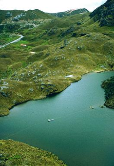
| Spatial Coverage Map | |
| General Documentation |
|
| Associated Resources |
|
| Publication Dates |
|
| Data Presentation Form | Digital table - digital representation of facts or figures systematically displayed, especially in columns
|
| Dataset Progress Status | Complete - production of the data has been completed |
| Data Update Frequency | Data update frequency not available |
| Supplemental Information |
ABSTRACT SUPPLIED BY ORIGINATOR: Greenland Ice Sheet (GrIS) outlet glaciers are currently losing mass, leading to sea level rise. Reconstructions of past outlet glacier behavior through the Holocene help us better understand how they respond to climate change. Kiattuut Sermiat, a southern Greenland outlet glacier near Narsarsuaq, is known to have experienced an unusually large Late Holocene advance that culminated at ~1600 cal yr BP and exceeded the glacier's Little Ice Age extent. We report sedimentary records from two lakes at slightly different elevations in an upland valley adjacent to Kiattuut Sermiat. These reveal when the outlet glacier's surface elevation was higher than during the Little Ice Age and constrain the associated outlet glacier surface elevation. We use bulk sediment geochemistry, magnetic susceptibility, color, texture, and the presence of aquatic plant macrofossils to distinguish between till, glaciolacustrine sediments, and organic lake sediments. Our 14C results above basal till recording regional deglaciation skew slightly old due to a reservoir effect but are generally consistent with regional deglaciation occurring ~11,000 cal yr BP. Neoglacial advance of Kiattuut Sermiat is recorded by deposition of glaciolacustrine sediments in the lower-elevation lake, which we infer was subsumed by an ice-dammed lake that formed along the glacier's margin just after ~3900 cal yr BP. This timing is consistent with several other glacial records in Greenland showing neoglacial cooling driving advance between ~4500–3000 cal yr BP. Given that glaciolacustrine sediments were deposited only in the lower-elevation lake, combined with glacial geomorphological evidence in the valley containing these lakes, we estimate the former ice margin's elevation to have been ~670 m a.s.l., compared with ~420 m a.s.l. today. The ice-dammed lake persisted until the glacier surface fell below this elevation at ~1600 cal yr BP. The retreat timing contrasts with overall evidence for cooling and glacier advance in the region at that time, so we infer that Kiattuut Sermiat's retreat may have resulted from reduced snowfall amounts and/or local glaciological complexity. High sensitivity to precipitation changes could also explain the relatively limited Little Ice Age advance of Kiattuut Sermiat compared with the earlier neoglacial advance.
|
| Purpose | Records of past climate and environment derived from lake sediment records. Parameter keywords describe what was measured in this dataset. Additional summary information can be found in the abstracts of papers listed in the dataset citations. |
| Dataset Citation |
|
| Cited Authors |
|
| Originators |
|
| Publishers |
|
| Theme keywords | Global Change Master Directory (GCMD) Science Keywords
|
| Data Center keywords | Global Change Master Directory (GCMD) Data Center Keywords
|
| Place keywords |
|
| Use Constraints |
|
| Access Constraints |
|
| Fees |
|
Last Modified: 2023-09-11
For questions about the information on this page, please email: ncei.info@noaa.gov