National Overview

December Highlights

December Temperature
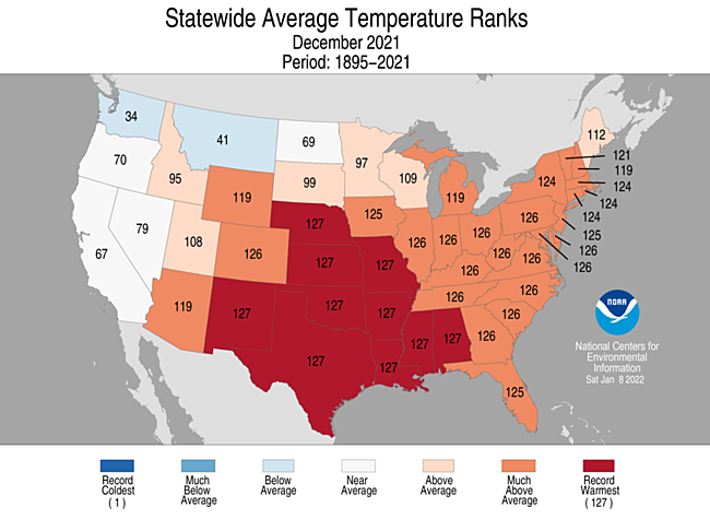
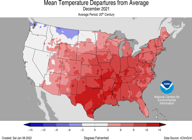
- For December, the average contiguous U.S. temperature was 39.3°F, 6.7°F above the 20th-century average. This ranked warmest for the 127-year period of record and exceeded the previous record set in Decmeber 2015.
- December was record warm across most of the central and southern Plains as well as the Middle and Lower Mississippi River Valley. 10 states ranked record warmest and an additional 21 states from the Rockies to the East Coast ranked among their top-five Decembers. Temperatures were below average across portions of the Pacific Northwest and northern Rockies.
- The most anomalous of the record heat observed during December was centered across the south-central U.S. Texas shattered their previous warmest December set in 1933 by 5.7°F. Oklahoma bested their 1933 record by 5.3°F. These record temperatures are similar to average temperatures for Texas and Oklahoma during late October and early November.
- The nationally averaged maximum temperature (daytime highs) was record warm during December at 50.0°F, 7.2°F above average. Temperatures were record warm from the High Plains and Deep South to the Ohio and Mississippi river valleys. Temperatures were above average from the Rockies to the East Coast and below average across portions of the West Coast and northern Rockies. Fifteen states across the central U.S. ranked record warm for daytime temperatures in December.
- The nationally averaged minimum temperature (overnight lows) during December was 28.7°F, 6.1°F above average and ranked second warmest in the 127-year record. Above-average overnight temperatures were observed across much of the Lower 48 with record warm temperatures in place across the Deep South and parts of the Lower Mississippi River Valley. Temperatures were below average across portions of the Northwest and northern Rockies. Six states across the southcentral U.S. ranked record warm for overnight temperatures during December.
- Alaska ranked in the middle third of the December record with a statewide average temperature of 6.6°F, 2.9°F above the long-term average. The warmest departures from average occurred across portions of the Central Interior and West Coast regions. Temperatures were below average for much of the Panhandle and Northeast Gulf regionsr.
- Warm records in December outpaced cold records by more than an eight-to-one margin. As of January 7, there were 11,013 warm daily high (6,323) and low (4,690) temperature records tied or broken during December. There were approximately 1,305 daily cold high (843) and low (462) temperature records set during the month.
- Based on NOAA's Residential Energy Demand Temperature Index (REDTI), the contiguous U.S. temperature-related energy demand during December was 16 percent of average and ranked as the 2nd-lowest value on record.
December Precipitation

- The December precipitation total for the contiguous U.S. was 2.38 inches, 0.03 inch above average, and ranked in the middle third of the 127-year period of record.
- Precipitation was above average across much of the West, northern Plains and portions of the Ohio Valley. Minnesota ranked second wettest for December. Precipitation was below average across much of the central and southern Plains, Midwest, Lower Mississippi Valley and along much of the East Coast.
- According to the January 4 U.S. Drought Monitor report, approximately 55 percent of the contiguous U.S. was in drought, similar to the extent of drought near the beginning of December. Drought conditions expanded or intensified across much of the central and southern Plains and Lower Mississippi River Valley. Drought severity lessened across the northern Rockies and throughout much of the West. Drought extent contracted across the Carolinas, Virginia and northern Plains.
Regional Highlights
These regional summaries were provided by the six Regional Climate Centers and reflect conditions in their respective regions. These six regions differ spatially from the nine climatic regions of the National Centers for Environmental Information.
Northeast Region (Information provided by the Northeast Regional Climate Center)
- The Northeast recorded its fifth warmest December since records began in 1895 with an average temperature of 34.3 degrees F (1.3 degrees C), 4.6 degrees F (2.6 degrees C) above normal. December average temperatures for the 12 Northeast states ranged from 1.7 degrees F (0.9 degrees C) above normal in Maine to 6.5 degrees F (3.6 degrees C) above normal in West Virginia. This December ranked among the 17 warmest Decembers on record for all 12 states: Maryland, second warmest; Delaware, New Jersey, Pennsylvania, and West Virginia, third warmest; New York and Rhode Island, fourth warmest; Connecticut and Massachusetts, fifth warmest; Vermont, eighth warmest; New Hampshire, 11th warmest; and Maine, 17th warmest.
- December was another drier-than-normal month for the Northeast. The region received 2.52 inches (64.01 mm) of precipitation, 67 percent of normal. December precipitation ranged from 27 percent of normal in Delaware to 84 percent of normal in New Hampshire. Five states experienced one of their 13 driest Decembers on record: Delaware, fifth driest; Maryland and New Jersey, sixth driest; and Connecticut and Rhode Island, 13th driest.
- The U.S. Drought Monitor released on December 2 showed 1 percent of the Northeast in severe drought, 1 percent in moderate drought, and 8 percent as abnormally dry. Below-normal precipitation in December caused moderate drought to be introduced in eastern West Virginia and eastern Maryland while abnormal dryness expanded in West Virginia, southern Pennsylvania, Maryland, Delaware, and southern New Jersey. In addition, drought and abnormal dryness persisted in northern New England. The U.S. Drought Monitor from December 28 showed 1 percent of the Northeast in severe drought, 3 percent in moderate drought, and 19 percent as abnormally dry.
- A powerful cold front moved through the Northeast on December 11. Some severe thunderstorms formed ahead the front, while damaging wind gusts affected the entire region after the front passed. The highest wind gusts were in the 35 to 55 mph (16 to 25 m/s) range for most areas, with gusts of 60 to 74 mph (27 to 33 m/s) reported in western and northern New York. Wind damage included downed trees and wires, snapped power poles, and damage to roofs and siding, particularly in western and northern New York. More than 196,000 customers in New York lost power. In addition, a seiche on Lake Erie caused water levels to reach 10.57 feet (3.22 m) at Buffalo, New York, the site’s sixth highest water level since at least 1975. Lakeshore flooding led to road closures and water entering some houses.
- For more information, please visit the Northeast Regional Climate Center Home Page.
Midwest Region (Information provided by the Midwest Regional Climate Center)
- December average temperature for the Midwest was 33.5 degrees F (0.9 degrees C), which was 5.8 degrees F (3.2 degrees C) above the 1991-2020 normal. Based on preliminary data, December 2021 was the 4th warmest December on record since 1895. The warmth was widespread, with temperature anomalies increasing from north to south across the region. Temperatures were above normal in all nine states, with statewide averages ranging from 1.4 degrees F (0.8 degrees C) above normal in Minnesota to a record-setting 9.4 degrees F (5.2 degrees C) above normal in Missouri. Maximum temperatures were 1-14 degrees F (1-8 degrees C) above normal across the region during December. There were 1014 maximum temperature records broken, with about half of those records set on December 15th and 16th. Missouri (282), Iowa (151), Illinois (142), and Wisconsin (111) reported the most maximum temperature records during the month. Several stations in Iowa broke the state’s December high temperature record of 74 degrees (23.3 degrees C) on December 15th – 16th. Minimum temperatures were 1-11 degrees F (1-6 degrees C) above normal across the region, except across northern Minnesota where minimum temperatures were up to 3 degrees F (2 degrees C) below normal. There were 440 warm minimum temperature records broken, with 104 records in Missouri alone.
- Average total precipitation was 2.64 inches (67 mm) for the Midwest during December, which was 0.45 inches (11 mm) above normal. Precipitation was variable across the region with statewide totals ranging from 0.53 inches (13 mm) below normal in Iowa to 1.8 inches (46 mm) above normal in Indiana. The most abundant precipitation fell across Minnesota, mostly as snow, where December precipitation was 200-400 percent of normal. The largest precipitation deficits were in western Iowa and northern Missouri where the monthly precipitation was 10-50 percent of normal. There were 342 precipitation records set during the month, with 127 records set across the region on December 11.
- Snowfall was above normal across northern Minnesota and northern Wisconsin where snow accumulations reached 20-40 inches (50-100 cm) during December. There were 164 snowfall records set in December, with most occurring in Minnesota (66) and Wisconsin (64). Heavy snow fell across southeast Minnesota on December 10th-11th, with some locations accumulating 21 inches (53 cm) and snowfall rates approaching 2 inches (5 cm) per hour. However, for much of the Midwest, snowfall deficits were widespread, including a lack of lake effect snow. In western Michigan and northern Indiana, snowfall was 5-15 inches (13-38 cm) below normal. Snowfall across northeast Ohio was 10-25 inches below normal. Warm temperatures delayed the measurable snowfall across the lower Midwest. Chicago set a record for the latest first measurable snowfall on December 28, breaking the previous record by eight days (records dating back to 1884).
- Drought conditions improved slightly in the Midwest during December, although patchy drought and dryness lingered across the northern and western states. The most noteworthy changes happened across northern Minnesota where D3 (extreme drought) was eliminated from the U.S. Drought Monitor and D2 (severe drought) improved 17 percent. Drought intensified in southern Wisconsin, and abnormal dryness expanded throughout western Missouri. The eastern portion of the region remained drought-free.
- A strong low-pressure system moved through the Midwest on December 10th-11th resulting in a widespread severe weather outbreak across Illinois, Indiana, Kentucky, Missouri, and Ohio. This storm resulted in 59 preliminary tornado reports and 234 high wind reports across the Midwest, with at least 65 confirmed fatalities and about 100 injuries in the region. Official damage surveys were conducted by the National Weather Service for 33 tornadoes in the Midwest, which included one EF-4 tornado and five EF-3 tornadoes. The communities of Mayfield, Kentucky and Dawson Springs, Kentucky saw extensive damage after taking a direct hit from a long-track EF-4 storm. The historic “Mayfield tornado,” as its commonly called, was on the ground for 165.7 miles, had peak winds of 190 mph, and resulted in 55+ fatalities. Media reports indicated over 1,000 homes and businesses were destroyed in Mayfield. An EF3 tornado with peak winds of 150 mph struck Edwardsville, Illinois causing extensive damage to an Amazon facility and killing six people. In Graves County, Kentucky, a peak wind gust of 107.1 mph was measured at a mesonet site and is currently under investigation for a potential statewide record. The economic impact of this storm, including affected areas outside of the 9-state Midwest region, was given an initial estimated cost of $18 billion.
- A second historic severe weather outbreak on December 15th resulted in a derecho that spawned tornadoes and destructive thunderstorms in Iowa, Illinois, Minnesota, Missouri, and Wisconsin. This was the first known derecho in December anywhere in the United States, according to the National Weather Service (NWS). This unseasonable storm system resulted in the Storm Prediction Center issuing their first-ever Moderate Risk area in the Iowa/Minnesota/Wisconsin region during the month of December (dating back to 1990) and their first-ever December tornado watch in Minnesota. As of December 23rd, the confirmed tornado count in Iowa reached 43, including 17 tornadoes rated EF2, setting an unofficial single-day tornado record (in any month) for the state. Prior to the December 15th outbreak, there had only been five tornadoes reported since 1950 in Iowa during December. As of December 29th, the NWS confirmed 20 tornadoes in Minnesota, marking the first December tornadoes on record for the state. As of December 27th, eight tornadoes had been confirmed by the NWS in Wisconsin. One fatality was reported in Minnesota after a falling tree struck a man in Rochester. One fatality was reported in eastern Iowa after high winds caused a semi-truck to roll.
- For further details on the weather and climate events in the Midwest, see the weekly and monthly reports at the Midwest Climate Watch page.
Southeast Region (Information provided by the Southeast Regional Climate Center)
- • Temperatures were much above average across much of the Southeast region for the month of December. Monthly mean temperatures were at least 2 degrees F (1.1 degrees C) above average for over 96 percent of the 190 long-term (i.e., period of record equaling or exceeding 50 years) stations across the region. None of the stations reported below average mean temperatures for the month. There were at least ten stations that observed monthly mean temperatures that were ranked their warmest value on record, including Montgomery, AL (1872-2021; at 9.3 degrees F (5.2 degrees C) above normal) and Pensacola, FL (1879-2021; at 9.1 degrees F (5.1 degrees C) above normal). Maximum temperatures ranged from 12.1 degrees F (6.7 degrees C) above normal in Haleyville, AL (1902-2021) to 0.9 degrees F (0.5 degrees C) above normal in San Juan, PR (1898-2021). There were several stations that had their highest counts of days reaching 70 degrees F (21 degrees C) or above, including Raleigh, NC (1887-2021; 12 days), and Florence, SC (1948-2021; 17 days). Daily temperature minimums ranged from 10.4 degrees F (5.8 degree C) above normal in Birmingham, AL (1895-2021) to 0.7 degrees F (0.4 degrees C) above normal in Fort Pierce, FL (1901-2021). The warmest weather of the month occurred from the 2nd through the 4th, as unusually warm air surged northward ahead of an approaching cold front. Daily maximum temperatures exceeded 70 degrees F (21 degrees C) across portions of every state. Hickory, NC (1949-2021) had a daily maximum temperature of 78 degrees F (26 degrees C) on the 3rd, and Morganton, NC (1893-2021) reached 80 degrees F (27 degrees C), making these their warmest December days on record. The University of South Carolina (1930-2021) in Columbia, SC, reported the highest daily maximum temperature in the region (excluding Puerto Rico) for the event at 84 degrees F (29 degrees C), which tied for its warmest December day on record. Christmas Day was also warm across much of the region, with Asheville, NC (1869-2021) reporting its warmest Christmas Day on record at 71 degrees F (22 degrees C) and Richmond, VA (1871-2021) observing the 3rd warmest at 73 degrees F (23 degrees C). In contrast, the coldest weather of the month across the Southeast occurred on the 21st through the 23rd, as the circulation around a departing mid-latitude cyclone ushered in cooler and drier air from Canada. Daily minimum temperatures fell below 30 degrees F (-1.1 degrees C) across portions of every state including Florida. Some locations in the higher elevations of North Carolina and Virginia fell below 20 degrees F (-6.7 degrees C), including Mt Mitchell (1925-2021) with a minimum temperature of 17 degrees F (-8.3 degrees C).
- • Precipitation was below normal across much the Southeast region for December, with monthly totals ranging from 75 to less than 25 percent of normal. The driest locations were found across much of Virginia, North Carolina, southern Florida and Puerto Rico. Indeed, Charlottesville, VA (1962-2021; 2nd driest) only observed 0.26 inches (7 mm) of precipitation, more than 2.7 inches (69 mm) below normal and Danville, VA (1916-2021; 4th driest) reported 0.65 inches (17 mm), which was more than 2.4 inches (61 mm) below normal. In contrast, the wettest locations for the month were located across central Georgia and the eastern part of the Florida Peninsula. Precipitation totals ranged from 100 to 200 percent of normal. Atlanta, GA (1878-2021; 29th wettest) measured 6.08 inches (154 mm) of precipitation for the month, over 1 inch (25 mm) above normal. A low-pressure system with associated cold front produced moderate rainfall on December 20th, with over 3 inches (76 mm) of precipitation measured in Atmore, AL (1940-2021) and 2.85 inches (72 mm) in Atlanta, GA (1878-2021), leading to reports of localized flooding and a few road closures. Measurable snowfall was confined to the higher elevations across the Southern Appalachian Mountains. The Mill Gap COOP station in VA measured the most snowfall for the region at 0.4 inches (10 mm), on the 9th. This was the second time on record that Mt. Mitchell (1925-2021) observed no snow for the entire month of December.
- • There were 120 reports of severe weather across the Southeast during December, which is 279 percent of the median monthly frequency of 43 reports during 2000-2019. There were 18 confirmed tornadoes reported for the month (8 EF-0, and 10 EF-1), which is double the monthly average of nine. The strongest tornado had winds of 95 mph (42 m/s) and occurred in Newton County, GA on December 31st. A dozen trees were uprooted along its path. The tornado reached peak intensity as it hit Veterans Middle school, removing significant amounts of siding and roofing from the gymnasium. It continued moving northeastward and crossed a Chick-Fil-A parking lot, where 2 cars were tossed and flipped. There were 6 minor injuries reported near the Chick-Fil-A. Another tornado, associated with a squall line, occurred in Bradford County, FL on December 8th. This tornado also had winds of 95 mph (42 m/s) and snapped several trees. No injuries or fatalities were reported. There were 13 reports of hail for the month, with the largest being golf-ball sized (1.75 inches) in Elmore County, AL on December 30th. There were 85 wind reports for the month, which is 258 percent of the average (33 reports). A thunderstorm produced a wind gust of 73 mph (33 m/s) in Manatee County, FL on the 21st, with reports of trees down and damage to a car due to a ‘wind driven coconut’. No injuries were reported.
- • Overall drought conditions changed very little in December. At the beginning of the month, a swath of severe drought (D2) stretched from northeastern North Carolina southwestward down to South Carolina, with a pocket of severe drought (D2) near the North Carolina/Virginia border. Moderate drought (D1) ringed the area of severe drought and stretched southward into Georgia. Most of the Southeast region north of Florida had abnormally dry conditions (D0). By the end of the month, the abnormally dry conditions decreased across much of Alabama and Georgia as did the moderate drought. However, the moderate drought expanded northward throughout most of Virginia. Drought conditions remained consistent across Puerto Rico for the month, with much of the island in moderate drought (D1) ringed by abnormally dry conditions (D0) and pockets of severe drought (D2) and extreme drought (D3) across the Virgin Islands. Farmers in the citrus growing region of Florida had to run irrigation due to the dry conditions. Fungal problems were reported to be under control, but disease in the southern part of the state was an issue due to the heavy fog late in December. Indeed, Gainesville, FL set a record (16 days) for number of dense fog (visibilities of ¼ mile or less) days in one month going back to 1973. Normal for the month of December is 6 dense fog days. Cool season forages and grazing pastures were growing very well with the mild weather conditions in Georgia and Alabama. However, with the daily warmth and cool nights, there were more respiratory problems in livestock. Fungal pathogens and weed control problems were noted as a concern due to the unusually warm December for parts of South Carolina. However, the warm and dry conditions allowed for producers to prepare land for spring and summer crops.
- For more information, please visit the Southeast Regional Climate Center Home Page.
High Plains Region (Information provided by the High Plains Regional Climate Center)
- Temperature
Above normal temperatures prevailed throughout most of December. Except for North Dakota, much of the region recorded much above normal temperatures. The southern part of the region experienced temperature departures of 6.0 – 10.0 degrees F (3.3-5.6 degrees C) above normal. This led to many areas ranking in the top 10 warmest December on record. Grand Is¬land, NE (period of record 1895-2021) and Norfolk, NE (period of record 1893-2021) both observed their warmest December on record. Several locations in both Colorado and Kansas recorded their second warmest December because of these much above normal tem¬peratures. Please see page 6 for additional rankings.
On the 15th, an extremely unusual and extreme event occurred in the High Plains. Temperatures in the southern part of the region exceeded 70.0 degrees F (21.0 degrees C) with departures up to 39.0 degrees F (21.7 degrees C) above normal in some areas. Many lo¬cations set their daily high record and their warmest temperature on record for December. Omaha, NE (period of record 1871-2021) observed their warmest December day on record, with a temperature of 74.0 degrees F (23.3 degrees C). These warm conditions lasted through most of the day until an extreme pressure system passed through, causing temperatures to drop over 40 degrees F (22.2 degrees C). The abnormally high tem-peratures combined with the significant winds from the pressure system led to large wildfires breaking out in north-central Kansas. The smoke from these fires was carried across Kansas and Nebraska, with the haze being seen as far away as Chicago. Over 163,000 acres (66,000 hectares) were burned before the fires were contained.
- Precipitation
Precipitation varied across the High Plains for De¬cember. The northern plains including North Da¬kota, western Colorado, and portions of Wyo¬ming and South Dakota observed above normal precipitation for the month. In the southern High Plains, below normal precipitation was recorded, with areas in Kansas and eastern Colorado receiv¬ing less than 5 percent of their normal precipitation.
This precipitation gradient resulted in some locations ranking in the top 10 wettest and driest December on record (see page 6 for December monthly rankings). Wichita, KS observed their driest December on record with 0.01 inches (0.25 mm) of precipitation. Chadron, NE tied with 2010 and other years for the driest Decem¬ber on record, observing a trace of precipitation. While the southern High Plains observed below normal pre¬cipitation, on December 15th an intense derecho moved through the region impacting Colorado, Nebraska, and Kansas with damaging winds, rain, tornadoes, and dust.
The largest precipitation was observed in western Col¬orado, with areas receiving over 3 inches (76 mm) above normal. Grand Junction, CO observed their wettest De¬cember on record with 2.08 inches (53 mm) exceeding their previous record of 2.05 inches (52 mm) in 2007.
Snowfall also varied across the region. Sisseton, SD observed their 2nd snowiest December on re¬cord with 20.3 inches (52 cm) of snow. Grand Forks, ND observed their 3rd snowiest December on re¬cord with 27.0 inches (69 cm) of snow, with the re¬cord being 36.0 inches (91 cm) and set in 2010. In contrast, Topeka, Wichita, and Dodge City, Kan¬sas observed their least snowy December on record, tied with multiple years, with 0.00 inches of snow.
- Active End to the Year for the Region
Warmer temperatures dominated most of the High Plains, while precipitation var¬ied across the region. The southern portion of the region was dry, while drought-strick¬en parts of North Dakota and western Colorado received beneficial precipitation. The warm and dry conditions in the southern portion of the region attributed to several noteworthy events.
A strong low-pressure system moved across the southern part of the region, leaving a trail of destruction in its wake. In Colorado, a 107 mph (172 km/h) wind gust was recorded in Lamar. The winds there caused power outages and damage to homes. To the east, Kansas experienced severe winds which led to substantial amounts of dust being stirred up. These dust storms resulted in the closure of several highways and numerous crashes along Interstate 70 in the western part of the state. The dry weather and intense winds also contributed to an outbreak of wildfires in north-central Kansas. Meanwhile, in neighboring Nebraska, both severe storms and snow occurred in a several-hour span. An extremely unusual derecho that was strong and fast-moving crossed the state, with numerous 75 mph (121 km/h) plus wind gusts and dozens of tornadoes reported. After the storm had passed, temperatures significantly dropped which led to snow. This light snowfall and the remaining high winds led to the first issuance of a Snow Squall Warning by the National Weather Service in Hastings, NE.
At the end of the month, a devastating wildfire broke out north of Denver, CO on the 30th. Winds gusted from 70 to 100 mph (113 to 161 km/h), with a maximum gust of 115 mph (185 km/h) recorded in Arvada. These fires rapidly spread across the foothills and engulfed up to 1,000 homes, making this among the most destructive fires in Colorado state history.
Southern Region (Information provided by the Southern Regional Climate Center)
December 2021 was the warmest winter month on record in the Southern Region, with records going back to 1895.
- Temperatures
December's average temperature across the Southern Region was 56.6 °F (13.7 °C). Not only did this far exceed the previous record of 52.0 °F (11.1 °C), but it broke the previous record for warmest winter month (December, January, or February), which was previously held by February 2021 at 56.2 °F (13.4 °C). At an individual state level, Arkansas at 52.8 °F (11.6 °C) had its warmest winter month on record, Louisiana at 61.2 °F (16.2 °C) tied its second warmest winter month on record (behind February 2017), Mississippi at 57.8 °F (14.3 °C) had its third warmest winter month on record (just 0.1° behind January 1950 and February 1932), Oklahoma tied February 1954 for its warmest winter month on record at 50.6 °F (10.3 °C), Tennessee at 4.98 °F (9.9 °C) tied for its second warmest winter month on record (even with February 1927 and behind December 2015), and Texas at 58.9 °F (14.9 °C) had its warmest winter month on record. The approximate percentage of individual stations with sufficient data having their warmest December on record by state: 80% in Arkansas, 75% in Louisiana, 65% in Mississippi, 100% in Oklahoma, 30% in Tennessee, and 97% in Texas. The highest temperature in the region was 96 °F (35.6 °C) at Stamford, west-central Texas, on December 27, while the lowest temperature was 4 °F (-15.6 °C) at Lipscomb, in the Texas Panhandle, on December 18.
- Precipitation
The high temperatures were accompanied by below-normal precipitation, particularly in western and southern portions of the Southern Region. Precipitation ranked 7th driest at 2.72" (69 mm) in Louisiana, 10th driest at 0.62" (16 mm) in Texas, 19th driest at 3.57" (91 mm) in Mississippi, 30th driest at 0.87" (22 mm) in Oklahoma, 50th driest at 3.62" (92 mm) in Arkansas, and 57th driest at 4.44" (113 mm) in Tennessee. The region-wide average ranked 14th driest at 1.72" (44 mm). Substantial portions of western Texas and Oklahoma recorded zero measurable precipitation for the month, and for many of those areas, particularly near Amarillo and Midland, this was the second consecutive month without measurable precipitation. Conversely, the largest monthly total was 8.26" (210 mm) at a CoCoRaHS station near Heber Springs, Arkansas.
- Drought
With the combination of extremely high temperatures and low precipitation, drought conditions worsened across the Southern Region. Drought coverage expanded from 41.7% on November 30, 20221 to 62.4% on January 4, 2022, and extreme drought expanded from 0.3% to 15.0% over the same time period. All states except Tennessee had some portions in extreme drought. In western Texas and Oklahoma, the primary drought impacts were to farmers (winter wheat) and ranchers (winter forage, water for cattle), as well as enhanced wildfire risk. Elsewhere, impacts have been relatively minor, but the situation would need to improve fairly quickly over the next two months to avoid substantial agricultural impacts.
- Severe Weather
There were 45 confirmed tornadoes in the Southern Region in December 2021, making it one of the most active winter months for tornadoes on record. Most of the tornadoes occurred during the tornado outbreak on December 10-11, 2021. While the greatest damage and loss of life was across the border in Kentucky, tornadoes were responsible for two fatalities in Arkansas and five fatalities in Tennessee. Both Arkansas and Tennessee received EF4 damage from the same tornado, which also passed over Missouri on its way from Arkansas to Tennessee. Arkansas also was struck by two EF2 tornadoes, while Tennessee had one EF3 tornado and three EF2 tornadoes. Both of the long-track tornadoes during this outbreak touched down in Tennessee before moving into Kentucky. According to the Tennessee SCO, the total number of tornadoes in December 2021 exceeded the total number of tornadoes in all previous Decembers combined. In addition to tornadoes, there were 31 reports of hail and 174 reports of high or damaging winds. About half of these severe weather reports occurred during the December 10-11 tornado outbreak, but the remainder were distributed across eight other days. Tennessee reported the largest number of wind events (108), while Arkansas had the most hail reports (13) and Texas reported the largest hail (2", or 5 cm). In addition, the strong winds and severe weather on December 15, while concentrated farther north, contributed to two substantial wildfires in the Texas panhandle that burned a combined total of almost 55 sq mi (141 sq km).
- For more information, please visit the Southern Regional Climate Center Home Page.
Western Region (Information provided by the Western Region Climate Center)
- Many regions in the West experienced stormy weather during December 2021, bringing welcome precipitation and near-to-slightly below average temperatures. December began with low-to-no snow throughout most major western U.S. mountains. Later in the month, heavy and sustained snowfall brought significant snowpack gains to California, Nevada, Oregon, Utah, Wyoming, Montana, and Washington. Lower elevations received beneficial rainfall. As a result, drought conditions improved across much of the West, especially in central Utah, coastal Oregon, central and southern California, northern Idaho, and western Montana. In the Desert Southwest, southern Nevada and Arizona received above-average precipitation that improved drought conditions. Continued warm and dry conditions maintained and exacerbated drought in New Mexico. Wetter-than-average conditions in Hawaii led to notable drought improvement.
- Persistent low pressure in the far western U.S. favored near- to below-average temperatures. Bellingham, WA, with a 70-year period of record, had its 10th coldest December with a mean temperature of 34.6°F (1.4°C), which is 5°F (2.8°C) below normal. In 82 years of records, Fort Bragg, CA recorded its 6th coldest December with a mean temperature of 44°F (6.7°C; 1°F (0.6°C) below normal). Temperatures were well-above average in the desert Southwest as a result of persistent ridging. With 76 years of records, Roswell, NM set a December heat record with mean temperatures of 50°F (10°C), which is 8°F (4.8°C) above normal. Tucson, Arizona, where record keeping began in 1930, experienced its second warmest December with a mean temperature of 57.2°F (14°C), which is 4°F (2.4°C) above normal.
- An active Pacific stormtrack brought much-needed precipitation to locations throughout the West. California and Nevada especially benefitted from an exceptionally wet December. Measuring 7.6 in. (193 mm) Santa Barbara, CA recorded its 2nd wettest December (240% of normal) since records began in 1941. December was the second wettest in the 121-year record for Los Angeles, CA, where 9.4 in. (239 mm) of rain fell (384% of normal). Ely, NV measured 2.6 in. (66 mm) of precipitation (367% of normal), its 3rd wettest December since record keeping began in 1888. The above-normal precipitation occurred inland across the northern half of the West, providing drought amelioration. With 70 years of observations, Rawlins, WY experienced its 9th wettest December, measuring 0.83 in precipitation (21 mm; 207% of normal). With 2.1 in. (53 mm) of precipitation (371% of normal), Grand Junction observed its wettest December in 120 years of record keeping. Dry conditions prevailed in New Mexico. Clayton, NM recorded no measurable precipitation during December, tying its driest December in 112 years of records.
- Sea surface temperatures (SST) in the vicinity of Hawaii remained 0.5-1°C above average. La Niña-like atmosphere-ocean conditions persisted further south in the tropical Pacific with strong anomalous tropical easterly winds and upwelling equatorial Kelvin waves driving cold (2-3° below average) SST anomalies along the equator. Kahului, HI (Maui) recorded tied its 14th warmest December since records began in 1954 with an average temperature of 74.5°F (23.6°C; 0.1°F (0°C) below normal). Above-normal precipitation brought drought improvement to all islands, especially Maui and Moloka’i. On Maui, Kahului observed 7.45 in. (189 mm) of precipitation, good for its 5th wettest December and 266% percent of average.
- Alaska experienced an eventful December with a range of weather and climate extremes. On December 26, Kodiak Harbor observed a maximum temperature of 67°F (19.4°C), the highest December temperature recorded anywhere in Alaska. With 78 in. (1,981 mm) of snowfall, Denali National Park observed its snowiest December and deepest total snow depth (60 in. (1,524 mm)) since record-keeping began in 1923. Western Alaska was wetter than normal. Nome measured the most December precipitation since records began in 1900 with 3.92 in. (99 mm) of precipitation falling (373% of normal). Southeastern Alaska was drier than normal. Cordova recorded its lowest December precipitation since records began in 1909, measuring 1.87 in. (47 mm; 23% of normal). Bering Sea ice achieved its highest mean extent since 2012. Significant Events for December 2021
- Sustained extreme snowfall in the southern Cascades and Sierra Nevada: A week-long snowstorm lasting from December 24-30 associated with a deep offshore trough, copious moisture transport, and favorable jet stream orientation brought the most December snow in over 40 years to the region. The Central Sierra Snow Laboratory, located on Donner Summit, CA, recorded 214 in. (5437 mm) of snow during December. This storm was a boon for water resources and winter recreation as it brought the southern Cascades and Sierra Nevada from essentially no snow to well-above average (many SNOTEL stations finished December at 150-250% of average) for the date. The low elevation snowfall, heavy precipitation, and strong winds caused multi-day closures of major roads and widespread multi-day power outages in rural communities. Holiday travelers and residents were stranded for days in the mountains.
- Blizzard warning and Kona Low precipitation: On December 4, the National Weather Service issued a rare blizzard warning for high elevations of the island of Hawai’I with forecast 100 mph (45 m/s) winds and 12 in. (300 mm) of snow. The storm, a Kona Low, brought heavy precipitation, with Honolulu reporting 7.92 in (201 mm), its second wettest day since 1940.
- For more information, please go to the Western Regional Climate Center Home Page.