United States Climate Reference Network (USCRN) Raw Observations from Datalogger

PDA Files

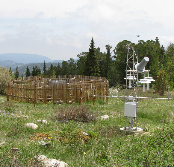
browse graphicStation Picture
Datalogger files are raw USCRN data. However, instead of being collected via satellite, the raw data are collected from station dataloggers (also referred to as PDAs--Personal Digital Assistant) in the field during site maintenance visits by NOAA/ATDD engineers. These data are uploaded to a site at Oak Ridge National Lab from where they are pulled by NCEI. These raw data are received as CSV formatted files--detailed documentation are required to read the data and will be provided to ingest. These files may not be available until months after the included observations are made. These data are considered of higher quality than USCRN Raw/streamed data.
  • USCRN Program requests that publications using this dataset should also cite the following article: Diamond, H.J., T.R. Karl, M.A. Palecki, C.B. Baker, J.E. Bell, R.D. Leeper, D.R. Easterling, J.H. Lawrimore, T.P. Meyers, M.R. Helfert, G. Goodge, and P.W. Thorne, 2013: U.S. Climate Reference Network after one decade of operations: status and assessment. Bull. Amer. Meteor. Soc., doi: 10.1175/BAMS-D-12-00170.
  • Please refer to Credit tab for full citation information.
  • NCEI DSI 6126_01
  • gov.noaa.ncdc:C00327
Order Data
Distribution Formats
  • CSV
    • File Specification:
    • File Compression:
Ordering InstructionsContact NCEI for other distribution options and instructions.
DistributorNOAA National Centers for Environmental Information
ncei.info@noaa.gov
Dataset Point of Contact Customer Engagement Branch
NOAA National Centers for Environmental Information
1-828-271-4800
ncei.orders@noaa.gov
Coverage Description
Time Period2000-11-15 to Present
Spatial Reference Systemurn:ogc:def:crs:EPSG::4326
Spatial Bounding Box Coordinates
N: 72.0
S: 18.0
E: -65.0
W: 172.0
Spatial Coverage Map
General Documentation
Associated Resources
Publication Dates
  • publication: 2000-11-15
Data Presentation Form Digital table - digital representation of facts or figures systematically displayed, especially in columns
Dataset Progress StatusOngoing - data is continually being updated
Data Update Frequency Irregular
PurposeUSCRN's primary goal is to provide future long-term homogeneous observations of temperature and precipitation that can be coupled to long-term historical observations for the detection and attribution of present and future climate change. Each station location is carefully selected to capture the representative climate regions of the nation. Data from the USCRN/USRCRN will be used in operational climate monitoring activities and for placing current climate anomalies into an historical perspective.
Use Limitations
  • Datalogger data is collected intermittently by a contractor (generally about once a year) and sent to the archive; this process can significantly delay the availability of the data. Datalogger data is incorporated into the USCRN system as soon as it is available from the archive.
Dataset Citation
  • USCRN Program requests that publications using this dataset should also cite the following article: Diamond, H.J., T.R. Karl, M.A. Palecki, C.B. Baker, J.E. Bell, R.D. Leeper, D.R. Easterling, J.H. Lawrimore, T.P. Meyers, M.R. Helfert, G. Goodge, and P.W. Thorne, 2013: U.S. Climate Reference Network after one decade of operations: status and assessment. Bull. Amer. Meteor. Soc., doi: 10.1175/BAMS-D-12-00170.
  • If emphasizing soil moisture/temperature data, USCRN Program requests that publications using this dataset should also cite the following article: Bell, J.E., M.A. Palecki, C.B. Baker, W.G. Collins, J.H. Lawrimore, R.D. Leeper, M.E. Hall, J. Kochendorfer, T.P. Meyers, T. Wilson, and H.J. Diamond. 2013: U.S. Climate Reference Network Soil Moisture and Temperature Observations. J. Hydrometeorol., doi: 10.1175/JHM-D-12-0146.1
Cited Authors
  • DOC/NOAA/NESDIS/NCDC > National Climatic Data Center, NESDIS, NOAA, U.S. Department of Commerce
Originators
  • DOC/NOAA/NESDIS/NCDC > National Climatic Data Center, NESDIS, NOAA, U.S. Department of Commerce
Publishers
  • DOC/NOAA/NESDIS/NCEI > National Centers for Environmental Information, NESDIS, NOAA, U.S. Department of Commerce
Theme keywordsGlobal Change Master Directory (GCMD) Science Keywords
  • Earth Science > Atmosphere > Atmospheric Temperature > Surface Temperature > Air Temperature
  • Earth Science > Atmosphere > Atmospheric Temperature > Surface Temperature > Maximum/Minimum Temperature
  • Earth Science > Atmosphere > Atmospheric Temperature > Surface Temperature
  • Earth Science > Atmosphere > Precipitation > Precipitation Amount
  • Earth Science > Atmosphere > Atmospheric Water Vapor > Water Vapor Indicators > Humidity
  • Earth Science > Atmosphere > Atmospheric Winds > Surface Winds
  • Earth Science > Atmosphere > Atmospheric Radiation > Incoming Solar Radiation
  • Earth Science > Atmosphere > Atmospheric Radiation > Solar Radiation
  • Earth Science > Land Surface > Surface Thermal Properties > Skin Temperature
  • Earth Science > Land Surface > Soils > Soil Moisture/Water Content
  • Earth Science > Land Surface > Soils > Soil Texture
  • Earth Science > Land Surface > Surface Thermal Properties > Land Surface Temperature
Global Climate Observing System (GCOS) Essential Climate Variables (ECVs)
  • Atmospheric - Surface - Air Temperature
  • Atmospheric - Surface - Wind Speed And Direction
  • Atmospheric - Surface - Precipitation
  • Atmospheric - Surface - Surface Radiation Budget
  • Atmospheric - Surface - Water Vapour
  • Terrestrial - Soil Moisture
  • Terrestrial - Land Surface Temperature
Data Center keywordsGlobal Change Master Directory (GCMD) Data Center Keywords
  • DOC/NOAA/NESDIS/NCDC > National Climatic Data Center, NESDIS, NOAA, U.S. Department of Commerce
  • DOC/NOAA/NESDIS/NCEI > National Centers for Environmental Information, NESDIS, NOAA, U.S. Department of Commerce
Platform keywordsGlobal Change Master Directory (GCMD) Platform Keywords
  • Meteorological Stations
Instrument keywordsGlobal Change Master Directory (GCMD) Instrument Keywords
  • Anemometers
  • Pyranometers
  • Fan-aspirated Radiation Shield
  • Rain Gauges
  • Soil Temperature Probe
  • Soil Moisture Probe
  • Temperature Sensors
  • Humidity Sensors
  • Thermometers
  • Disdrometers
Place keywordsGlobal Change Master Directory (GCMD) Location Keywords
  • Geographic Region > Polar
  • Geographic Region > Mid-Latitude
  • Continent > North America
  • Continent > North America > United States Of America
  • Continent > North America > United States Of America > Hawaii
  • Continent > North America > United States Of America > Alaska
Project keywords
  • U.S. Climate Reference Network > USCRN
Data Resolution keywordsGlobal Change Master Directory (GCMD) Horizontal Data Resolution Keywords
  • 250 km - < 500 km or approximately 2.5 degrees - < 5.0 degrees
  • 1 meter - < 30 meters
Global Change Master Directory (GCMD) Vertical Data Resolution Keywords
  • < 1 meter
  • 1 meter - < 10 meters
Global Change Master Directory (GCMD) Temporal Data Resolution Keywords
  • Hourly - < Daily
  • 1 minute - < 1 hour
Stratum keywordsGlobal Change Master Directory (GCMD) Location Keywords
  • Vertical Location > Land Surface
  • Vertical Location > Boundary Layer
Use Constraints
  • USCRN Program requests that publications using this dataset should also cite the following article: Diamond, H.J., T.R. Karl, M.A. Palecki, C.B. Baker, J.E. Bell, R.D. Leeper, D.R. Easterling, J.H. Lawrimore, T.P. Meyers, M.R. Helfert, G. Goodge, and P.W. Thorne, 2013: U.S. Climate Reference Network after one decade of operations: status and assessment. Bull. Amer. Meteor. Soc., doi: 10.1175/BAMS-D-12-00170.
  • If emphasizing soil moisture/temperature data, USCRN Program requests that publications using this dataset should also cite the following article: Bell, J.E., M.A. Palecki, C.B. Baker, W.G. Collins, J.H. Lawrimore, R.D. Leeper, M.E. Hall, J. Kochendorfer, T.P. Meyers, T. Wilson, and H.J. Diamond. 2013: U.S. Climate Reference Network Soil Moisture and Temperature Observations. J. Hydrometeorol., doi: 10.1175/JHM-D-12-0146.1
Fees
  • In most cases, electronic downloads of the data are free. However, fees may apply for custom orders, data certifications, copies of analog materials, and data distribution on physical media.
Lineage information for: repository
Processing Steps
  • 2015-04-22T00:00:00 - NOAA created the National Centers for Environmental Information (NCEI) by merging NOAA's National Climatic Data Center (NCDC), National Geophysical Data Center (NGDC), and National Oceanographic Data Center (NODC), including the National Coastal Data Development Center (NCDDC), per the Consolidated and Further Continuing Appropriations Act, 2015, Public Law 113-235. NCEI launched publicly on April 22, 2015.
Acquisition Information (collection)
Instrument
  • Anemometers
  • Pyranometers
  • Rain Gauges
  • Fan-aspirated Radiation Shield
  • Soil Temperature Probe
  • Soil Moisture Probe
  • Temperature Sensors
  • Humidity Sensors
  • Infrared Thermometers
  • Disdrometers
Platform
  • Meteorological Stations
Last Modified: 2023-06-23
For questions about the information on this page, please email: ncei.info@noaa.gov