1-Minute Page 1 Surface Weather Observations from the Automated Surface Observing Systems (ASOS) Network

browse graphic
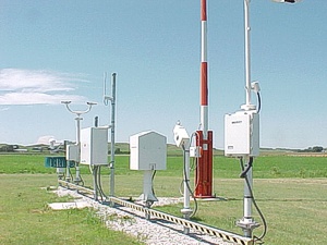
ASOS weather sensors (credit: NOAA/NWS)
This dataset includes one-minute observations for visibility extinction coefficient, 2-minute average and 5-second peak wind speed and direction, and runway visual range for approximately 900 stations in the U.S., Puerto Rico, the U.S. Virgin Islands, and some Pacific island territories as part of the Automated Surface Observing Systems (ASOS) network. The ASOS Program is a joint effort of the National Weather Service (NWS), the Federal Aviation Administration (FAA), and the Department of Defense (DOD). The ASOS network was designed to support weather forecast activities and aviation operations and, at the same time, support the needs of the meteorological, hydrological, and climatological research communities. The ASOS 1-minute page 1 and page 2 data were collected and processed by the NOAA National Centers for Environmental Information (NCEI).
  • Cite as: NOAA National Weather Service, U.S. Federal Aviation Administration, U.S. Department of Defense, NOAA National Centers for Environmental Information (2005): 1-Minute Page 1 Surface Weather Observations from the Automated Surface Observing Systems (ASOS) Network. [indicate subset used]. NOAA National Centers for Environmental Information. NCEI DSI 6405_02. [access date].
  • NCEI DSI 6405_02
  • gov.noaa.ncdc:C00386
Download Data
Distribution Formats
  • ASCII Text
Ordering InstructionsContact NCEI for other distribution options and instructions.
DistributorNOAA National Centers for Environmental Information
ncei.info@noaa.gov
Dataset Point of Contact Customer Engagement Branch
NOAA National Centers for Environmental Information
1-828-271-4800
ncei.orders@noaa.gov
Time Period1998-06-01 to Present
Spatial Bounding Box Coordinates
N: 72.0
S: 15.0
E: -60.0
W: 170.0
Spatial Coverage Map
General Documentation
Publication Dates
  • publication: 2005
Data Presentation Form Digital table - digital representation of facts or figures systematically displayed, especially in columns
Dataset Progress StatusOngoing - data is continually being updated
Data Update Frequency Daily
PurposeTo make a wide range of high temporal resolution climatic data available to researchers and the broader public and private sectors.
Dataset Citation
  • Cite as: NOAA National Weather Service, U.S. Federal Aviation Administration, U.S. Department of Defense, NOAA National Centers for Environmental Information (2005): 1-Minute Page 1 Surface Weather Observations from the Automated Surface Observing Systems (ASOS) Network. [indicate subset used]. NOAA National Centers for Environmental Information. NCEI DSI 6405_02. [access date].
Cited Authors
  • NOAA National Weather Service
  • U.S. Federal Aviation Administration
  • U.S. Department of Defense
  • NOAA National Centers for Environmental Information
Originators
  • NOAA National Weather Service
  • U.S. Federal Aviation Administration
  • U.S. Department of Defense
  • NOAA National Centers for Environmental Information
Publishers
  • NOAA National Centers for Environmental Information
Theme keywordsGlobal Change Master Directory (GCMD) Science Keywords
  • Earth Science > Atmosphere > Atmospheric Winds > Surface Winds
  • Earth Science > Atmosphere > Weather Events > Lightning
  • Earth Science > Atmosphere > Atmospheric Pressure > Atmospheric Pressure Measurements
  • Earth Science > Atmosphere > Atmospheric Temperature > Dew Point Temperature
  • Earth Science > Atmosphere > Atmospheric Temperature > Surface Temperature > Air Temperature
  • Earth Science > Atmosphere > Atmospheric Water Vapor > Water Vapor Indicators > Dew Point Temperature
  • Earth Science > Atmosphere > Clouds > Cloud Properties > Cloud Height
  • Earth Science > Atmosphere > Precipitation > Precipitation Amount
  • Earth Science > Atmosphere > Precipitation > Liquid Precipitation
  • Earth Science > Atmosphere > Precipitation > Liquid Precipitation > Rain > Freezing Rain
  • Earth Science > Atmosphere > Precipitation > Liquid Precipitation > Rain
  • Earth Science > Atmosphere > Precipitation > Solid Precipitation
  • Earth Science > Atmosphere > Precipitation > solid precipitation > snow
  • Earth Science > Atmosphere > Precipitation > snow water equivalent
Data Center keywordsGlobal Change Master Directory (GCMD) Data Center Keywords
  • DOC/NOAA/NESDIS/NCEI > National Centers for Environmental Information, NESDIS, NOAA, U.S. Department of Commerce
  • DOC/NOAA/NESDIS/NCDC > National Climatic Data Center, NESDIS, NOAA, U.S. Department of Commerce
  • DOC/NOAA/NWS > National Weather Service, NOAA, U.S. Department of Commerce
  • DOT/FAA > Federal Aviation Administration, U.S. Department of Transportation
  • DOD > U.S. Department of Defense
Place keywordsGlobal Change Master Directory (GCMD) Location Keywords
  • Continent > North America > United States Of America
  • Ocean > Atlantic Ocean > North Atlantic Ocean > Caribbean Sea > Puerto Rico
Stratum keywordsGlobal Change Master Directory (GCMD) Location Keywords
  • Vertical Location > Land Surface
  • Vertical Location > Troposphere
Use Constraints
  • Cite as: NOAA National Weather Service, U.S. Federal Aviation Administration, U.S. Department of Defense, NOAA National Centers for Environmental Information (2005): 1-Minute Page 1 Surface Weather Observations from the Automated Surface Observing Systems (ASOS) Network. [indicate subset used]. NOAA National Centers for Environmental Information. NCEI DSI 6405_02. [access date].
  • Use liability: NOAA and NCEI cannot provide any warranty as to the accuracy, reliability, or completeness of furnished data. Users assume responsibility to determine the usability of these data. The user is responsible for the results of any application of this data for other than its intended purpose.
Access Constraints
  • Distribution liability: NOAA and NCEI make no warranty, expressed or implied, regarding these data, nor does the fact of distribution constitute such a warranty. NOAA and NCEI cannot assume liability for any damages caused by any errors or omissions in these data. If appropriate, NCEI can only certify that the data it distributes are an authentic copy of the records that were accepted for inclusion in the NCEI archives.
Fees
  • In most cases, electronic downloads of the data are free. However, fees may apply for custom orders, data certifications, copies of analog materials, and data distribution on physical media.
Lineage information for: dataset
Lineage StatementThe data have been archived by the NOAA National Centers for Environmental Information.
Processing Steps
  • The NOAA National Centers for Environmental Information acquired and processed the station data from the ASOS network within one day of the observations. The data processing steps included data acquisition, basic quality assurance, assimilation into monthly station files, and data archive and access. The basic quality assurance included identifying improper record formats, incorrectly transmitted station IDs, and determining if record lengths and observing dates and times are within acceptable bounds. Additional data for the previous month may have been processed and made available during the first to third day of the following month, and on rare occasions later in that month, due to technical issues that delayed the processing of data in real-time.
Lineage information for: repository
Processing Steps
  • 2015-04-22T00:00:00 - NOAA created the National Centers for Environmental Information (NCEI) by merging NOAA's National Climatic Data Center (NCDC), National Geophysical Data Center (NGDC), and National Oceanographic Data Center (NODC), including the National Coastal Data Development Center (NCDDC), per the Consolidated and Further Continuing Appropriations Act, 2015, Public Law 113-235. NCEI launched publicly on April 22, 2015.
Acquisition Information (collection)
Instrument
  • ANEMOMETERS
  • AEROVANES
  • CEILOMETERS
  • TEMPERATURE SENSORS
  • PRESSURE SENSORS
  • RAIN GAUGES
Platform
  • Automated Surface Observing Systems (ASOS) network
Last Modified: 2023-06-23
For questions about the information on this page, please email: ncei.info@noaa.gov