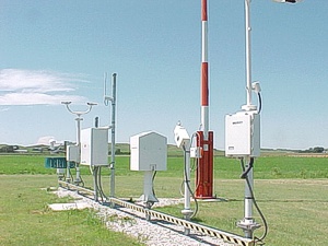
1-Minute Page 2 Surface Weather Observations from the Automated Surface Observing Systems (ASOS) Network
This dataset includes one-minute observations for precipitation type and amount, station pressure, temperature, dew point temperature, lightning detection elements, and the Frozen Precipitation Sensor Frequency for approximately 900 stations in the U.S., Puerto Rico, the U.S. Virgin Islands, and some Pacific island territories as part of the Automated Surface Observing Systems (ASOS) network. The ASOS Program is a joint effort of the National Weather Service (NWS), the Federal Aviation Administration (FAA), and the Department of Defense (DOD). The ASOS network was designed to support weather forecast activities and aviation operations and, at the same time, support the needs of the meteorological, hydrological, and climatological research communities. The ASOS 1-minute page 1 and page 2 data were collected and processed by the NOAA National Centers for Environmental Information (NCEI).
- Cite as: NOAA National Weather Service, U.S. Federal Aviation Administration, U.S. Department of Defense, NOAA National Centers for Environmental Information (2005): 1-Minute Page 2 Surface Weather Observations from the Automated Surface Observing Systems (ASOS) Network. [indicate subset used]. NOAA National Centers for Environmental Information. NCEI DSI 6406_02. [access date].
- NCEI DSI 6406_02
- gov.noaa.ncdc:C00387
C00387
| Download Data |
|
| Distribution Formats |
|
| Ordering Instructions | Contact NCEI for other distribution options and instructions. |
| Distributor | NOAA National Centers for Environmental Information
ncei.info@noaa.gov |
| Dataset Point of Contact | Customer Engagement Branch
NOAA National Centers for Environmental Information 1-828-271-4800 ncei.orders@noaa.gov |
| Time Period | 1998-06-01 to Present |
| Spatial Bounding Box Coordinates |
N: 72.0
S: 15.0
E: -60.0
W: 170.0
|
| Spatial Coverage Map | |
| General Documentation |
|
| Publication Dates |
|
| Data Presentation Form | Digital table - digital representation of facts or figures systematically displayed, especially in columns
|
| Dataset Progress Status | Ongoing - data is continually being updated |
| Data Update Frequency | Daily |
| Purpose | To make a wide range of high temporal resolution climatic data available to researchers and the broader public and private sectors. |
| Dataset Citation |
|
| Cited Authors |
|
| Originators |
|
| Publishers |
|
| Theme keywords | Global Change Master Directory (GCMD) Science Keywords
|
| Data Center keywords | Global Change Master Directory (GCMD) Data Center Keywords
|
| Place keywords | Global Change Master Directory (GCMD) Location Keywords
|
| Stratum keywords | Global Change Master Directory (GCMD) Location Keywords
|
| Use Constraints |
|
| Access Constraints |
|
| Fees |
|
| Lineage Statement | The data have been archived by the NOAA National Centers for Environmental Information. |
| Processing Steps |
|
| Processing Steps |
|
| Instrument |
|
| Platform |
|
Last Modified: 2023-06-23
For questions about the information on this page, please email: ncei.info@noaa.gov
