NOAA NEXt-Generation RADar (NEXRAD) Products
National Geospatial Data Asset (NGDA) NEXRAD (NEXt-Generation RADar) Products
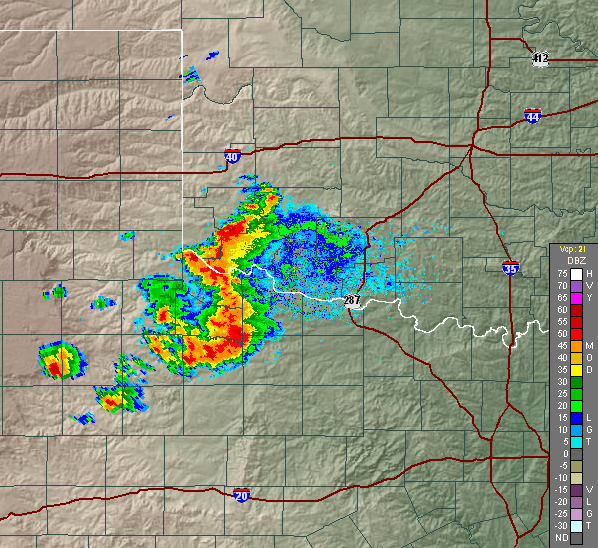 NEXRAD reflectivity image
This dataset consists of Level III weather radar products collected from Next-Generation Radar (NEXRAD) stations located in the contiguous United States, Alaska, Hawaii, U.S. territories and at military base sites. NEXRAD is a network of 160 high-resolution Doppler weather radars operated by the NOAA National Weather Service (NWS), the Federal Aviation Administration (FAA), and the U.S. Air Force (USAF). Doppler radars detect atmospheric precipitation and winds, which allow scientists to track and anticipate weather events, such as rain, ice pellets, snow, hail, and tornadoes, as well as some non-weather objects like birds and insects. NEXRAD stations use the Weather Surveillance Radar - 1988, Doppler (WSR-88D) system. This is a 10 cm wavelength (S-Band) radar that operates at a frequency between 2,700 and 3,000 MHz. The radar system operates in two basic modes: a slow-scanning Clear Air Mode (Mode B) for analyzing air movements when there is little or no precipitation activity in the area, and a Precipitation Mode (Mode A) with a faster scan for tracking active weather. The two modes employ nine Volume Coverage Patterns (VCPs) to adequately sample the atmosphere based on weather conditions. A VCP is a series of 360 degree sweeps of the antenna at pre-determined elevation angles and pulse repetition frequencies completed in a specified period of time. The radar scan times 4.5, 5, 6 or 10 minutes depending on the selected VCP. During 2008, the WSR-88D radars were upgraded to produce increased spatial resolution data, called Super Resolution. The earlier Legacy Resolution data provides radar reflectivity at 1.0 degree azimuthal by 1 km range gate resolution to a range of 460 km, and Doppler velocity and spectrum width at 1.0 degree azimuthal by 250 m range gate resolution to a range of 230 km. The upgraded Super Resolution data provides radar reflectivity at 0.5 degree azimuthal by 250 m range gate resolution to a range of 460 km, and Doppler velocity and spectrum width at 0.5 degree azimuthal by 250 m range gate resolution to a range of 300 km. Super resolution makes a compromise of slightly decreased noise reduction for a large gain in resolution. In 2010, the deployment of the Dual Polarization (Dual Pol) capability to NEXRAD sites began with the first operational Dual Pol radar in May 2011. Dual Pol radar capability adds vertical polarization to the previous horizontal radar waves, in order to more accurately discern the return signal. This allows the radar to better distinguish between types of precipitation (e.g., rain, hail and snow), improves rainfall estimates, improves data retrieval in mountainous terrain, and aids in removal of non-weather artifacts. The NEXRAD products are divided in two data processing levels. The lower Level II data are base products at original resolution. Level II data are recorded at all NWS and most USAF and FAA WSR-88D sites. From the Level II quantities, computer processing generates numerous meteorological analysis Level III products. The Level III data consists of reduced resolution, low-bandwidth, base products as well as many derived, post-processed products. Level III products are recorded at most U.S. sites, though non-US sites do not have Level III products. There are over 40 Level III products available from the NCDC. General products for Level III include the base and composite reflectivity, storm relative velocity, vertical integrated liquid, echo tops and VAD wind profile. Precipitation products for Level III include estimated ground accumulated rainfall amounts for one and three hour periods, storm totals, and digital arrays. Estimates are based on reflectivity to rainfall rate (Z-R) relationships. Overlay products for Level III are alphanumeric data that give detailed information on certain parameters for an identified storm cell. These include storm structure, hail index, mesocyclone identification, tornadic vortex signature, and storm tracking information. Radar messages for Level III are sent by the radar site to users in order to know more about the radar status and special product data. NEXRAD data are provided to the NOAA National Climatic Data Center for archiving and dissemination to users. Data coverage varies by station and ranges from May 1992 to 1 day from present. Most stations began observing in the mid-1990s, and most period of records are continuous.
- Cite this dataset when used as a source.
- NCEI DSI 7000
- NCEI DSI 6500
- gov.noaa.ncdc:C00682
C00682
| Search Data |
|
| Download Data |
|
| Distribution Formats |
|
| Ordering Instructions | Contact NCEI for other distribution options and instructions. |
| Distributor | NOAA National Centers for Environmental Information
ncei.info@noaa.gov |
| Dataset Point of Contact | Customer Engagement Branch
NOAA National Centers for Environmental Information 1-828-271-4800 ncei.orders@noaa.gov |
| Time Period | 1992-05-07 to Present |
| Spatial Reference System | EPSG:4326 |
| Spatial Bounding Box Coordinates |
N: 68.0
S: 11.0
E: -64.0
W: 124.0
|
| Spatial Coverage Map | |
| Dataset Information |
|
| General Documentation |
|
| Associated Resources |
|
| Publication Dates |
|
| Data Presentation Form | Digital image
|
| Dataset Progress Status | Ongoing - data is continually being updated |
| Data Update Frequency | Continual |
| Purpose | NEXRAD Level III products are used to remotely detect atmospheric features, such as precipitation, precipitation-type, storms, turbulence and wind, for operational forecasting and data research analysis. |
| Dataset Citation |
|
| Cited Authors |
|
| Originators |
|
| Publishers |
|
| Theme keywords | Global Change Master Directory (GCMD) Science Keywords
|
| Data Center keywords | Global Change Master Directory (GCMD) Data Center Keywords
|
| Platform keywords | Global Change Master Directory (GCMD) Platform Keywords
|
| Instrument keywords | Global Change Master Directory (GCMD) Instrument Keywords
|
| Place keywords | Global Change Master Directory (GCMD) Location Keywords
|
| Stratum keywords | Global Change Master Directory (GCMD) Location Keywords
|
| Use Constraints |
|
| Access Constraints |
|
| Fees |
|
| Lineage Statement | NEXRAD Level III products were collected by the NOAA National Weather Service (NWS) and are archived at the NOAA National Climatic Data Center (NCDC). |
| Processor |
|
| Processing Steps |
|
| Source Datasets |
|
| Processing Steps |
|
| Instrument |
|
| Platform |
|
| Operation |
|
Last Modified: 2023-09-06
For questions about the information on this page, please email: ncei.info@noaa.gov