Continental United States Hurricane Strikes Since 1950

browse graphicNOAA produced Continental United States Hurricane Strikes Since 1950 poster
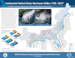
This is an annual edition poster showing all of the hurricanes having impacted the continental U.S. from 1950 to 2022. This 36x28 inch glossy poster gives a quick look of the location and strength of each hurricane which impacted the continental United States. The poster is also available to download as a PDF file. The map includes the name, category strength, year, and approximate strike location of each hurricane. For the 2022 edition two new hurricanes were added: Hurricane Ian, a Category-4 Hurricane hitting the western Florida Peninsula with a secondary landfall in South Carolina, and Hurricane Nicole, a Category-1 hurricane hitting the east coast of Florida.
Cite this dataset when used as a source.
  • POSTER-HURRICANES
  • gov.noaa.ncdc:C00694
Download Data
Order Data
Distribution Formats
  • XML
  • Printed Poster
  • PDF
Ordering InstructionsContact NCEI for other distribution options and instructions.
DistributorNOAA National Centers for Environmental Information
ncei.info@noaa.gov
Dataset Point of Contact Axel Graumann
DOC/NOAA/NESDIS/NCEI > National Centers for Environmental Information, NESDIS, NOAA, U.S. Department of Commerce
+1 828-271-4800
ncei.orders@noaa.gov
Time Period1950-01-01 to 2022-12-31
Spatial Bounding Box Coordinates
N: 46
S: 24
E: -69
W: -102
Spatial Coverage Map
General Documentation
Publication Dates
  • revision: 2023
Data Presentation Form Digital image
Hardcopy image - image archived in analog format
Dataset Progress StatusComplete - production of the data has been completed
Data Update Frequency Annually
PurposeTo provide high quality posters for significant hurricane events for the public.
Use Limitations
  • None
Cited Authors
  • DOC/NOAA/NESDIS/NCEI > National Centers for Environmental Information, NESDIS, NOAA, U.S. Department of Commerce
Publishers
  • NOAA National Centers for Environmental Information
Theme keywordsGlobal Change Master Directory (GCMD) Science Keywords
  • Earth Science > Atmosphere > Weather Events > Tropical Cyclones
  • Earth Science > Human Dimensions > Natural Hazards > Tropical Cyclones > Hurricanes
  • Earth Science > Atmosphere > Weather Events > Rain Storms
  • Earth Science > Human Dimensions > Natural Hazards > Tropical Cyclones > Typhoons
  • Earth Science > Atmosphere > Atmospheric Winds > Surface Winds
  • Earth Science > Oceans > Ocean Winds > Surface Winds
  • Earth Science Services > Data Analysis And Visualization > Visualization/Image Processing
Data Center keywordsGlobal Change Master Directory (GCMD) Data Center Keywords
  • DOC/NOAA/NESDIS/NCDC > National Climatic Data Center, NESDIS, NOAA, U.S. Department of Commerce
  • DOC/NOAA/NESDIS/NCEI > National Centers for Environmental Information, NESDIS, NOAA, U.S. Department of Commerce
Platform keywordsGlobal Change Master Directory (GCMD) Platform Keywords
  • Earth Observation Satellites > GOES (Geostationary Operational Environmental Satellite) > GOES-12 > Geostationary Operational Environmental Satellite 12
Place keywordsGlobal Change Master Directory (GCMD) Location Keywords
  • Continent > North America > United States Of America > Texas
  • Continent > North America > United States Of America > Louisiana
  • Continent > North America > United States Of America > Mississippi
  • Continent > North America > United States Of America > Florida
  • Continent > North America > United States Of America > Georgia
  • Continent > North America > United States Of America > Alabama
  • Continent > North America > United States Of America > South Carolina
  • Continent > North America > United States Of America > North Carolina
  • Continent > North America > United States Of America > Virginia
  • Continent > North America > United States Of America > West Virginia
  • Continent > North America > United States Of America > Maryland
  • Continent > North America > United States Of America > Delaware
  • Continent > North America > United States Of America > District Of Columbia
  • Continent > North America > United States Of America > Pennsylvania
  • Continent > North America > United States Of America > New Jersey
  • Continent > North America > United States Of America > New York
  • Continent > North America > United States Of America > Rhode Island
  • Continent > North America > United States Of America > Connecticut
  • Continent > North America > United States Of America > Massachusetts
  • Continent > North America > United States Of America > New Hampshire
  • Continent > North America > United States Of America > Vermont
  • Continent > North America > United States Of America > Maine,
Stratum keywordsGlobal Change Master Directory (GCMD) Location Keywords
  • Vertical Location > Land Surface
  • Vertical Location > Sea Surface
Use ConstraintsNo constraint information available
Other ConstraintsNone
Fees
  • In most cases, electronic downloads of the data are free. However, fees may apply for custom orders, data certifications, copies of analog materials, and data distribution on physical media.
Lineage information for: dataset
Lineage StatementComposite poster of hurricane images archived at NOAA.
Processing Environmentpaper forms
Lineage information for: repository
Processing Steps
  • 2015-04-22T00:00:00 - NOAA created the National Centers for Environmental Information (NCEI) by merging NOAA's National Climatic Data Center (NCDC), National Geophysical Data Center (NGDC), and National Oceanographic Data Center (NODC), including the National Coastal Data Development Center (NCDDC), per the Consolidated and Further Continuing Appropriations Act, 2015, Public Law 113-235. NCEI launched publicly on April 22, 2015.
Last Modified: 2023-06-23
For questions about the information on this page, please email: ncei.info@noaa.gov