NOAA Climate Data Record (CDR) of Gridded Satellite Data from ISCCP B1 (GridSat-B1) Infrared Channel Brightness Temperature, Version 1 (Version Superseded)
Geostationary IR Channel Brightness Temperature - GridSat B1
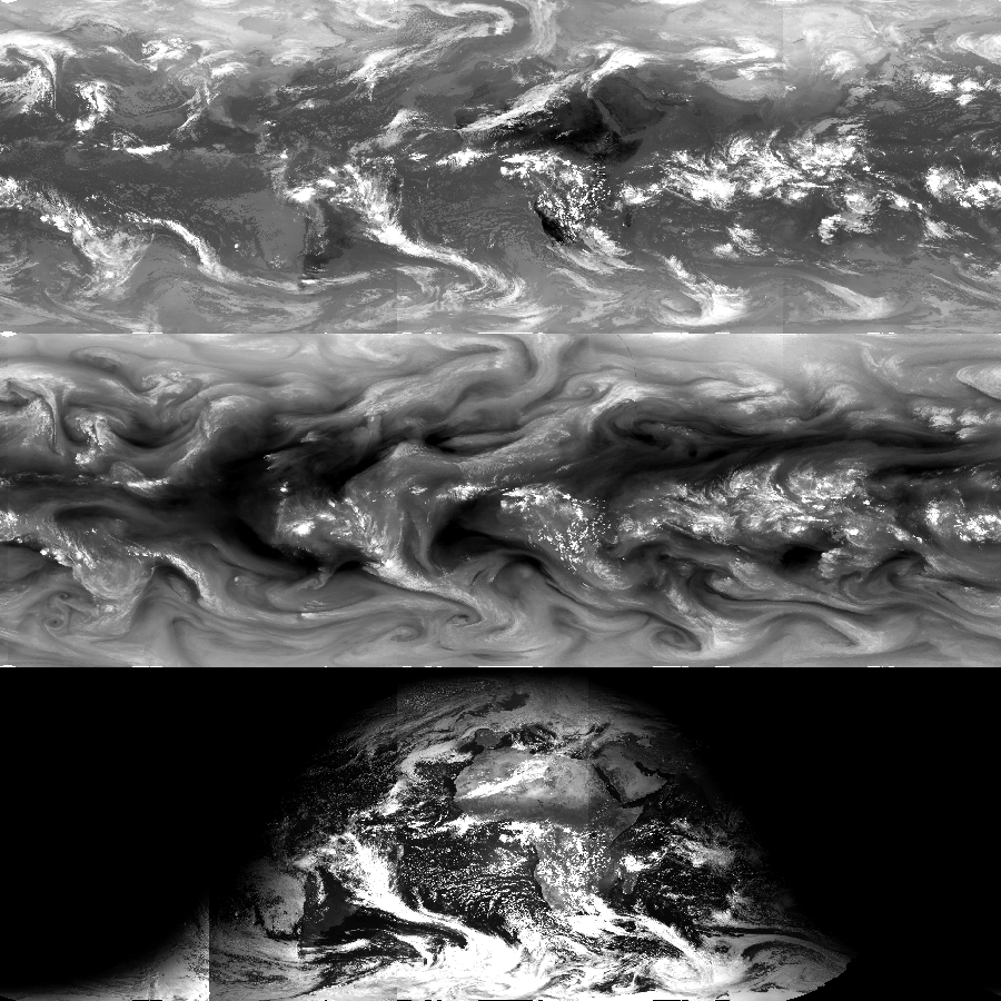 Image of IR window, water vapor and visible data.
*Note: This dataset version has been superseded by a newer version. It is highly recommended that users access the current version. Users should only use this version for special cases, such as reproducing studies that used this version.* The Intersatellite Calibrated Gridded Satellite Data from International Satellite Cloud Climatology Project (ISCCP) B1 data (or GridSat-B1) provides a uniform set of quality controlled observations for the infrared (IR) window channel at 11 microns for a 30 year record beginning in 1980. The ISCCP B1 data are quality controlled, calibrated, remapped and merged to provide nearly Global coverage of equal-angle uniform observations of IR brightness temperatures every 3 hours. Temporal normalization is performed via inter-satellite calibration against High Resolution Infrared Radiation Sounder (HIRS) channel 12 data during the ISCCP B1 period of record. For each 3-hour time segment (from 00 to 23 UTC), the IR channel from each satellite product is mapped to an equal-angle grid using nearest-neighbor sampling. Since the ISCCP B1 spatial resolution is approximately 8km, the resolution of the equal area grid is 0.07 degrees Latitude (approximately 8km at the Equator). The data span the Globe in Longitude and range from 70 degrees South to 70 degrees North Latitude. Satellites are merged by selecting the nadir-most observations for each grid point. Areas of satellite overlap are retained by storing data in layers. Channel primary layers (nadir-most observation) are written as 2-dimensional grids in the netCDF file, which facilitates processing of multiple files (e.g., aggregation of multiple times, etc.). Subsequent layers are written as either 2D grids or staggered arrays, which are 1-dimensional arrays that only record data when present. The fundamental Climate Data Record (CDR) is stored using netCDF and CF conventions to facilitate data usage with a wide range of processing software.
- Cite as: Knapp, Kenneth R.; NOAA CDR Program; (2010): NOAA Climate Data Record (CDR) of Gridded Satellite Data from ISCCP B1 (GridSat-B1) Infrared Channel Brightness Temperature, Version 1. [indicate subset used]. NOAA National Centers for Environmental Information. [access date].
- NCEI DSI 3648_01
- gov.noaa.ncdc:C00830
C00830
| Distribution Formats |
|
| Ordering Instructions | Contact NCEI for other distribution options and instructions. |
| Distributor | NOAA National Centers for Environmental Information
ncei.info@noaa.gov |
| Dataset Point of Contact | NOAA Climate Data Record Program Office
DOC/NOAA/NESDIS/NCEI > National Centers for Environmental Information, NESDIS, NOAA, U.S. Department of Commerce +1 (828) 271-4800 gridsat_b1_contacts@noaa.gov |
| Time Period | 1980-01-01 to 2009-12-31 |
| Spatial Bounding Box Coordinates |
N: 70.0
S: -70.0
E: 180.0
W: -180.0
|
| Spatial Coverage Map | |
| General Documentation |
|
| Associated Resources |
|
| Publication Dates |
|
| Edition | v01r01 |
| Data Presentation Form | Digital image
|
| Dataset Progress Status | Complete - production of the data has been completed
Historical archive - data has been stored in an offline storage facility Superseded - replaced by new |
| Data Update Frequency | Not planned |
| Purpose | These data can be applied to studies of tropical cyclones, the Intertropical Convergence Zone (ITCZ), global and regional precipitation monitoring, diurnal variation and outgoing longwave radiation. The data are intended to facilitate use of Global infrared measurements from geostationary satellites by non-satellite experts and to help facilitate large-scale processing via tools designed to process CF-compliant netCDF files. |
| Use Limitations |
|
| Dataset Citation |
|
| Cited Authors |
|
| Principal Investigators |
|
| Collaborators |
|
| Publishers |
|
| Theme keywords | Global Change Master Directory (GCMD) Science Keywords
|
| Data Center keywords | Global Change Master Directory (GCMD) Data Center Keywords
|
| Platform keywords | Global Change Master Directory (GCMD) Platform Keywords
|
| Instrument keywords | Global Change Master Directory (GCMD) Instrument Keywords
|
| Place keywords | Global Change Master Directory (GCMD) Location Keywords
|
| Project keywords | Global Change Master Directory (GCMD) Project Keywords
|
| Use Constraints |
|
| Access Constraints |
|
| Fees |
|
| Processing Steps |
|
Last Modified: 2023-09-14
For questions about the information on this page, please email: ncei.info@noaa.gov