NOAA Soil Moisture Products System (SMOPS) Daily Blended Products
SMOPS
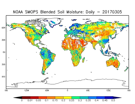 NOAA SMOPS Daily Blended Soil Moisture
The Soil Moisture Operational Products System (SMOPS) combines soil moisture retrievals from multiple satellite sensors to provide a global soil moisture map with high spatial coverage. SMOPS provides a seamless soil moisture map over global land from six satellites, including GPM, SMAP, GCOM-W1, SMOS, Metop-A, and Metop-B. The global soil moisture maps are generated in daily intervals with the most recent 24 hours of soil moisture from multiple retrieval algorithms, and mapped with a cylindrical projection on 0.25 x 0.25 degree grid. For each grid point of the map, the output includes soil moisture values as a percentage (vol/vol) of the surface (top 1-5 cm) soil layer with associated quality information and metadata. The daily product is available in netCDF file format. The archive period of record begins in March 2017. See the Details Section below for more information.
- Cite this dataset when used as a source.
- gov.noaa.ncdc:C00994
- gov.noaa.class:SMOPS
C00994
| Order Data |
|
| Distribution Formats |
|
| Ordering Instructions | Contact NCEI for other distribution options and instructions. |
| Distributor | NOAA National Centers for Environmental Information
ncei.info@noaa.gov |
| Dataset Point of Contact | Customer Engagement Branch
DOC/NOAA/NESDIS/NCEI > National Centers for Environmental Information, NESDIS, NOAA, U.S. Department of Commerce +1 828-271-4800 ncei.sat.info@noaa.gov |
| Coverage Description | |
| Time Period | 2017-03-15 to Present |
| Spatial Bounding Box Coordinates |
N: 90.0
S: -90.0
E: 180.0
W: -180.0
|
| Spatial Coverage Map | |
| General Documentation |
|
| Processing Documents |
|
| Publication Dates |
|
| Edition | Version 1.0 |
| Data Presentation Form | Digital image
|
| Dataset Progress Status | Ongoing - data is continually being updated |
| Data Update Frequency | Daily |
| Purpose | This dataset provides quality measurements of soil moisture variables from multiple instruments and platforms. |
| Use Limitations |
|
| Dataset Citation |
|
| Cited Authors |
|
| Originators |
|
| Principal Investigators |
|
| Contributors |
|
| Publishers |
|
| Theme keywords | Global Change Master Directory (GCMD) Science Keywords
|
| Data Center keywords | Global Change Master Directory (GCMD) Data Center Keywords
|
| Platform keywords | Global Change Master Directory (GCMD) Platform Keywords
|
| Instrument keywords | Global Change Master Directory (GCMD) Instrument Keywords
|
| Place keywords | Global Change Master Directory (GCMD) Location Keywords
|
| Project keywords | Global Change Master Directory (GCMD) Project Keywords
|
| Data Resolution keywords | Global Change Master Directory (GCMD) Horizontal Data Resolution Keywords
|
| Use Constraints |
|
| Access Constraints |
|
| Fees |
|
| Processing Steps |
|
Last Modified: 2023-06-23
For questions about the information on this page, please email: ncei.info@noaa.gov