Regional Hydrodynamic Model Outputs of the NOAA St. John's River Operational Forecast System (SJROFS)

CO-OPS SJROFS

browse graphic
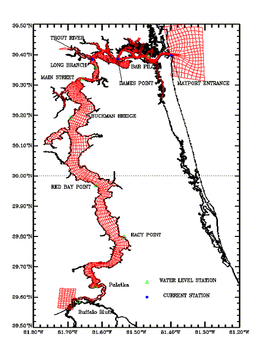
St. John's River model grid map
NOAA's National Ocean Service (NOS) has developed a St. John's River Operational Forecast System (SJROFS). The Environmental Fluid Dynamics Code (EFDC) has been used to perform operational nowcasts and forecasts for the Lower St. John's River. The EFDC model solves the three-dimensional, vertically hydrostatic, free surface, turbulent averaged equations of motions for a variable density fluid. The physics of the EFDC model and many aspects of the computation scheme are equivalent to the widely used Blumberg-Mellor model (POM). SJROFS is to produce hourly nowcasts and run every six hours four times daily forecasts of total water level and current velocity in the River to be used by the commercial and recreational maritime community.
  • Cite As: NOAA National Ocean Service; NOAA National Weather Service; NOAA Office of Oceanic and Atmospheric Research (2017): Regional Hydrodynamic Model Outputs of the NOAA St. John's River Operational Forecast System (SJROFS). [indicate subset used]. NOAA National Centers for Environmental Information. https://doi.org/10.25921/fztr-mf31. Accessed [date].
  • NCEI DSI 2014_01
  • gov.noaa.ncdc:C01357
Download Data
Distribution Formats
  • netCDF (Version: 3 classic)
  • netCDF (Version: 4)
Ordering InstructionsContact NCEI for other distribution options and instructions.
DistributorNOAA National Centers for Environmental Information
ncei.info@noaa.gov
Dataset Point of Contact Customer Engagement Branch
NOAA National Centers for Environmental Information
1-828-271-4800
ncei.orders@noaa.gov
Time Period2014-01-01 to Present (time interval: 6-minute)
Spatial Bounding Box Coordinates
N: 30.0
S: 29.0
E: -81.0
W: -81.0
Spatial Coverage Map
General Documentation
Associated Resources
Publication Dates
  • publication: 2017
Dataset Progress StatusOngoing - data is continually being updated
Data Update Frequency Daily
PurposeThis dataset is available to the public for a wide variety of uses including scientific research and analysis.
Dataset Citation
  • Cite As: NOAA National Ocean Service; NOAA National Weather Service; NOAA Office of Oceanic and Atmospheric Research (2017): Regional Hydrodynamic Model Outputs of the NOAA St. John's River Operational Forecast System (SJROFS). [indicate subset used]. NOAA National Centers for Environmental Information. https://doi.org/10.25921/fztr-mf31. Accessed [date].
Cited Authors
  • NOAA National Weather Service
  • NOAA National Ocean Service
  • NOAA Office of Oceanic and Atmospheric Research
Publishers
Theme keywordsGlobal Change Master Directory (GCMD) Science Keywords
  • Earth Science > Oceans > Salinity/Density
  • Earth Science > Oceans > Tides > Tidal Currents
  • Earth Science > Oceans > Coastal Processes > Longshore Currents
  • Earth Science > Oceans > Ocean Winds > Surface Winds
  • Earth Science > Oceans > Ocean Temperature > Water Temperature
  • Earth Science > Oceans > Coastal Processes > Sea Surface Height
Data Center keywordsGlobal Change Master Directory (GCMD) Data Center Keywords
  • DOC/NOAA/NOS/CO-OPS > Center for Operational Oceanographic Products and Services, National Ocean Service, NOAA, U.S. Department of Commerce
  • DOC/NOAA/NESDIS/NCEI > National Centers for Environmental Information, NESDIS, NOAA, U.S. Department of Commerce
  • DOC/NOAA/NESDIS/NCDC > National Climatic Data Center, NESDIS, NOAA, U.S. Department of Commerce
Platform keywordsGlobal Change Master Directory (GCMD) Platform Keywords
  • Other > Models > Operational Models
Place keywordsGlobal Change Master Directory (GCMD) Location Keywords
  • Continent > North America > United States Of America > Florida
Use Constraints
  • Cite As: NOAA National Ocean Service; NOAA National Weather Service; NOAA Office of Oceanic and Atmospheric Research (2017): Regional Hydrodynamic Model Outputs of the NOAA St. John's River Operational Forecast System (SJROFS). [indicate subset used]. NOAA National Centers for Environmental Information. https://doi.org/10.25921/fztr-mf31. Accessed [date].
  • Use liability: NOAA and NCEI cannot provide any warranty as to the accuracy, reliability, or completeness of furnished data. Users assume responsibility to determine the usability of these data. The user is responsible for the results of any application of this data for other than its intended purpose.
  • Disclaimers - Center for Operational Oceanographic Products and Services (CO-OPS): https://tidesandcurrents.noaa.gov/disclaimers.html
Access Constraints
  • Distribution liability: NOAA and NCEI make no warranty, expressed or implied, regarding these data, nor does the fact of distribution constitute such a warranty. NOAA and NCEI cannot assume liability for any damages caused by any errors or omissions in these data. If appropriate, NCEI can only certify that the data it distributes are an authentic copy of the records that were accepted for inclusion in the NCEI archives.
Fees
  • In most cases, electronic downloads of the data are free. However, fees may apply for custom orders, data certifications, copies of analog materials, and data distribution on physical media.
Lineage information for: dataset
Lineage StatementThe model output was produced by the NOAA National Weather Service, the NOAA National Ocean Service, and the NOAA Office of Oceanic and Atmospheric Research, and it is archived by the NOAA National Centers for Environmental Information.
Lineage information for: repository
Processing Steps
  • 2015-04-22T00:00:00 - NOAA created the National Centers for Environmental Information (NCEI) by merging NOAA's National Climatic Data Center (NCDC), National Geophysical Data Center (NGDC), and National Oceanographic Data Center (NODC), including the National Coastal Data Development Center (NCDDC), per the Consolidated and Further Continuing Appropriations Act, 2015, Public Law 113-235. NCEI launched publicly on April 22, 2015.
Last Modified: 2023-08-08
For questions about the information on this page, please email: ncei.info@noaa.gov