NOAA JPSS Visible Infrared Imaging Radiometer Suite (VIIRS) Aerosol Optical Thickness (AOT) and Aerosol Particle Size Parameter (APSP) Environmental Data Record (EDR) from IDPS
VIIRS-Aeros-EDR
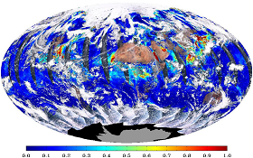 Example of global Aerosol Optical Thickness (AOT) EDR at 550nm overlaid on top of a true color (RGB) image.
This dataset contains a high quality operational Environmental Data Record (EDR) of Aerosol Optical Thickness (AOT) from the Visible Infrared Imaging Radiometer Suite (VIIRS) instrument onboard the Suomi-NPP satellite and is produced by the NOAA Environmental Satellite, Data, and Information Service (NESDIS). The algorithm that is used to derive the VIIRS AOT is based on an algorithm originally developed for the Moderate Resolution Imaging Spectroradiometer (MODIS) sensor but is adapted and improved upon for use by VIIRS. The algorithm utilizes eleven different spectral bands ranging from 0.412 to 2.250 microns as well as the Angstrom Exponent to calculate values stored as 96 x 400 arrays of 16-bit integers with a matching scale stored in each granule. The spatial resolution is 6 kilometers (km) which is derived from an intermediate product (IP) of 8 x 8 750 meter pixels. The temporal resolution provides global coverage daily. By default, IDPS VIIRS AOT data obtained from the Comprehensive Large-Array Stewardship System (CLASS) are distributed in four 86-second granules in Hierarchical Data Format v.5 (HDF5) with metadata attributes included. It is important to note that the Aerosol Particle Size Parameter (APSP) is included in this EDR and is reported as Ångström exponent.
- Cite as: Kondragunta, Shobha, Laszlo, Istvan, Qiu, Shuang and NOAA JPSS Program Office (2012): NOAA JPSS Visible Infrared Imaging Radiometer Suite (VIIRS) Aerosol Optical Thickness (AOT) and Particle Size Parameter (APSP) Environmental Data Record (EDR) from IDPS. [indicate subset used]. NOAA National Centers for Environmental Information. [access date].
- gov.noaa.ncdc:C01402
- gov.noaa.class:VIIRS_EDR
- JPSS Product ID:VAOOO
C01402
| Download Data |
|
| Order Data |
|
| Distribution Formats |
|
| Ordering Instructions | Contact NCEI for other distribution options and instructions. |
| Distributor | NOAA National Centers for Environmental Information
ncei.info@noaa.gov |
| Dataset Point of Contact | Customer Engagement Branch
DOC/NOAA/NESDIS/NCEI > National Centers for Environmental Information, NESDIS, NOAA, U.S. Department of Commerce ncei.sat.info@noaa.gov |
| Time Period | 2012-05-02 to Present (time interval: 24-hour) |
| Spatial Reference System | urn:ogc:def:crs:EPSG::4326 |
| Spatial Bounding Box Coordinates |
N: 90.0
S: -90.0
E: 180.0
W: -180.0
|
| Spatial Coverage Map | |
| General Documentation |
|
| Processing Documents |
|
| Associated Resources |
|
| Publication Dates |
|
| Edition | Validated |
| Data Presentation Form | Digital image
|
| Dataset Progress Status | Ongoing - data is continually being updated |
| Data Update Frequency | Continual |
| Purpose | The S-NPP VIIRS aerosol products are designed for use by the climate, air quality, research, applied, private, governmental, and military communities for the purpose of research, forecasts, communication, and policy decisions. |
| Use Limitations |
|
| Dataset Citation |
|
| Cited Authors |
|
| Originators |
|
| Principal Investigators |
|
| Publishers |
|
| Theme keywords | Global Change Master Directory (GCMD) Science Keywords
|
| Data Center keywords | Global Change Master Directory (GCMD) Data Center Keywords
|
| Platform keywords | Global Change Master Directory (GCMD) Platform Keywords
|
| Instrument keywords | Global Change Master Directory (GCMD) Instrument Keywords
|
| Place keywords | Global Change Master Directory (GCMD) Location Keywords
|
| Project keywords | Global Change Master Directory (GCMD) Project Keywords
|
| Data Resolution keywords | Global Change Master Directory (GCMD) Horizontal Data Resolution Keywords
|
| Stratum keywords | Global Change Master Directory (GCMD) Location Keywords
|
| Use Constraints |
|
| Access Constraints |
|
| Fees |
|
| Lineage Statement | These data were produced by the JPSS Interface Data Processing Segment (IDPS) and are archived at the NOAA National Centers for Environmental Information (NCEI). |
| Processor |
|
| Processing Steps |
|
| Processing Documents |
|
| Source Datasets |
|
| Processing Steps |
|
Last Modified: 2023-06-23
For questions about the information on this page, please email: ncei.info@noaa.gov