NOAA JPSS Visible Infrared Imaging Radiometer Suite (VIIRS) Cloud Base Height (CBH) Environmental Data Record (EDR) from IDPS
VIIRS-CBH-EDR
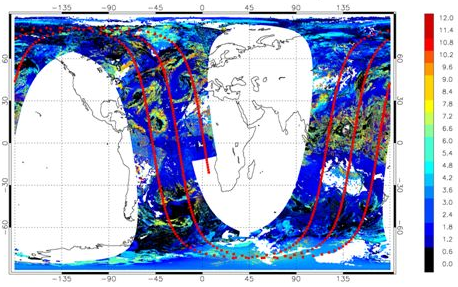 Example of VIIRS Cloud Base Height with CloudSat overpass track (red) on September 26, 2013
This dataset contains a high quality operational Environmental Data Record (EDR) of Cloud Base Heights (CBH) from the Visible Infrared Imaging Radiometer Suite (VIIRS) instrument onboard the Suomi-NPP satellite and is produced by the NOAA Environmental Satellite, Data, and Information Service (NESDIS). CBH is defined as the height above sea level at which cloud bases occur and is derived by subtracting Cloud Optical Thickness (COT) values from Cloud Top Height (CTH) values. The algorithm also incorporates data from the Cloud Mask Intermediate Product (IP). Each square cell is an average of reported base heights within that cell. If a cloud layer occupies only a portion of the cell then the average is reported for only the portion of the cell covered by the cloud. The spatial resolution of the EDR is 6 km and data are collected during day and night passes which provides global coverage at a temporal resolution of approximately every 12 hours. By default, VIIRS CBH IDPS data obtained from the Comprehensive Large Array-Data Stewardship System (CLASS) are distributed in four 86-second granules in Hierarchical Data Format V. 5 (HDF5) with metadata attributes.
- Cite as: Heidinger, Andrew, Qiu, Shuang, and NOAA JPSS Program Office (2013): NOAA JPSS Visible Infrared Imaging Radiometer Suite (VIIRS) Cloud Base Height (CBH) Environmental Data Record (EDR) from IDPS. [indicate subset used]. NOAA National Centers for Environmental Information. [access date].
- gov.noaa.ncdc:C01403
- gov.noaa.class:VIIRS_EDR
- JPSS Product ID:VCBHO
C01403
| Download Data |
|
| Order Data |
|
| Distribution Formats |
|
| Ordering Instructions | Contact NCEI for other distribution options and instructions. |
| Distributor | NOAA National Centers for Environmental Information
ncei.info@noaa.gov |
| Dataset Point of Contact | Customer Engagement Branch
NOAA National Centers for Environmental Information 1-828-271-4800 ncei.orders@noaa.gov |
| Time Period | 2013-04-27 to Present (time interval: 12-hour) |
| Spatial Reference System | urn:ogc:def:crs:EPSG::4326 |
| Spatial Bounding Box Coordinates |
N: 90.0
S: -90.0
E: 180.0
W: -180.0
|
| Spatial Coverage Map | |
| General Documentation |
|
| Processing Documents |
|
| Associated Resources |
|
| Publication Dates |
|
| Edition | Validated |
| Data Presentation Form | Digital image
|
| Dataset Progress Status | Ongoing - data is continually being updated |
| Data Update Frequency | Continual |
| Purpose | This data set provides a high quality Environmental Data Record (EDR) of Cloud Base Heights (CBH). As a high quality EDR, this data set could be used by the general aviation community for cloud ceiling and visibility determinations or as an environmental variable in climate models. |
| Use Limitations |
|
| Dataset Citation |
|
| Cited Authors |
|
| Originators |
|
| Principal Investigators |
|
| Publishers |
|
| Theme keywords | Global Change Master Directory (GCMD) Science Keywords
|
| Data Center keywords | Global Change Master Directory (GCMD) Data Center Keywords
|
| Platform keywords | Global Change Master Directory (GCMD) Platform Keywords
|
| Instrument keywords | Global Change Master Directory (GCMD) Instrument Keywords
|
| Place keywords | Global Change Master Directory (GCMD) Location Keywords
|
| Project keywords | Global Change Master Directory (GCMD) Project Keywords
|
| Data Resolution keywords | Global Change Master Directory (GCMD) Horizontal Data Resolution Keywords
|
| Stratum keywords | Global Change Master Directory (GCMD) Location Keywords
|
| Use Constraints |
|
| Access Constraints |
|
| Fees |
|
| Lineage Statement | These data were produced by the JPSS Interface Data Processing Segment (IDPS) and are archived at the NOAA National Centers for Environmental Information (NCEI). |
| Processor |
|
| Processing Steps |
|
| Processing Documents |
|
| Source Datasets |
|
| Processing Steps |
|
Last Modified: 2023-06-23
For questions about the information on this page, please email: ncei.info@noaa.gov