NOAA JPSS Visible Infrared Imaging Radiometer Suite (VIIRS) Cloud Cover Layer (CCL) Environmental Data Record (EDR) from IDPS
VIIRS-CCL-EDR
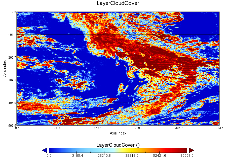 S-NPP VIIRS Cloud Cover Layer EDR image taken over a portion of North America on April 28, 2016
This dataset contains a high quality Environmental Data Record (EDR) of Cloud Cover Layers (CCL) from the Visible Infrared Imaging Radiometer Suite (VIIRS) instrument onboard the Suomi-NPP satellite and is produced by the NOAA Environmental Satellite, Data, and Information Service (NESDIS). The CCL EDR is a cloud product derived from several other Retained Intermediate Products (RIPs) including, Cloud Optical Properties (COP), Cloud Top Parameters (CTP), Perform Parallax Correction (PPC), and Cloud Base Height (CBH). Cloud cover is the fraction of a given area on the Earth's surface where a line segment extending between two altitudes intersects a cloud. CCL also includes a binary map (cloudy/not cloudy) that highlights cells that contain clouds. The RIPs are 750 meter spatial resolution products and the output EDRs are gridded to 6 km resolution. Global coverage is generated approximately every 12 hours. By default, IDPS VIIRS CCL data obtained from the Comprehensive Large-Array Stewardship System (CLASS) are distributed in four aggregated 86-second granules in Hierarchical Data Format v.5 (HDF5) with metadata attributes included.
- Cite as: Heidinger, Andrew, Qiu, Shuang, and NOAA JPSS Program Office (2013): NOAA JPSS Visible Infrared Imaging Radiometer Suite (VIIRS) Cloud Cover Layers (CCL) Environmental Data Record (EDR) from IDPS. [indicate subset used]. NOAA National Centers for Environmental Information. [access date].
- gov.noaa.ncdc:C01404
- gov.noaa.class:VIIRS_EDR
- JPSS Product ID:VCCLO
C01404
| Download Data |
|
| Order Data |
|
| Distribution Formats |
|
| Ordering Instructions | Contact NCEI for other distribution options and instructions. |
| Distributor | NOAA National Centers for Environmental Information
ncei.info@noaa.gov |
| Dataset Point of Contact | Customer Engagement Branch
DOC/NOAA/NESDIS/NCEI > National Centers for Environmental Information, NESDIS, NOAA, U.S. Department of Commerce ncei.sat.info@noaa.gov |
| Time Period | 2013-04-27 to Present (time interval: 12-hour) |
| Spatial Reference System | urn:ogc:def:crs:EPSG::4326 |
| Spatial Bounding Box Coordinates |
N: 90.0
S: -90.0
E: 180.0
W: -180.0
|
| Spatial Coverage Map | |
| General Documentation |
|
| Processing Documents |
|
| Associated Resources |
|
| Publication Dates |
|
| Edition | Validated |
| Data Presentation Form | Digital image
|
| Dataset Progress Status | Ongoing - data is continually being updated |
| Data Update Frequency | Continual |
| Purpose | The VIIRS CCL EDR is used extensively in numerical weather and climate prediction models. CCL could also be useful to the general aviation community. |
| Use Limitations |
|
| Dataset Citation |
|
| Cited Authors |
|
| Originators |
|
| Principal Investigators |
|
| Publishers |
|
| Theme keywords | Global Change Master Directory (GCMD) Science Keywords
|
| Data Center keywords | Global Change Master Directory (GCMD) Data Center Keywords
|
| Platform keywords | Global Change Master Directory (GCMD) Platform Keywords
|
| Instrument keywords | Global Change Master Directory (GCMD) Instrument Keywords
|
| Place keywords | Global Change Master Directory (GCMD) Location Keywords
|
| Project keywords | Global Change Master Directory (GCMD) Project Keywords
|
| Data Resolution keywords | Global Change Master Directory (GCMD) Horizontal Data Resolution Keywords
|
| Stratum keywords | Global Change Master Directory (GCMD) Location Keywords
|
| Use Constraints |
|
| Access Constraints |
|
| Fees |
|
| Lineage Statement | These data were produced by the JPSS Interface Data Processing Segment (IDPS) and are archived at the NOAA National Centers for Environmental Information (NCEI). |
| Processor |
|
| Processing Steps |
|
| Processing Documents |
|
| Source Datasets |
|
| Processing Steps |
|
Last Modified: 2023-06-23
For questions about the information on this page, please email: ncei.info@noaa.gov