NOAA JPSS Advanced Technology Microwave Sounder (ATMS) Remapped to Cross-track Infrared Sounder (CrIS) Sensor Data Record (SDR) from IDPS
JPSS-ATMS-CrIS
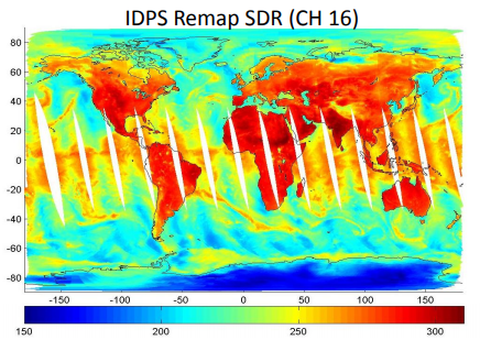 Example of a global image of remapped ATMS SDR channel 16. Courtesy of the JPSS LTM system.
The Advanced Technology Microwave Sounder (ATMS) is a 22 channel microwave sounder on board the Suomi NPP satellite that provides continuous cross-track scanning in a 824 km sun-synchronous orbit. This operational data set provides a sensor data record (SDR) remapped to instrument data from the Cross-track Infrared Sounder (CrIS). In combination with CrIS, a hyperspectral infrared sounder, ATMS will provide temperature and humidity profile information of sufficient accuracy, even in the presence of many cloud types, to improve further the presently respectable accuracy of operational numerical weather prediction models. ATMS should also extend the time series data on mean global upper air temperatures that began with its predecessor instrument, MSU, over twenty years ago. It will also yield global precipitation-rate retrievals for rain and snow with ~15-km resolution near nadir when combined with CrIS and 35-km resolution stand alone. By default, ATMS Remapped to CrIS SDR data obtained from the Comprehensive Large Array-Data Stewardship System (CLASS) are distributed as aggregated files of four 86-second granules in HDF5 file format with metadata attributes.
- Cite as: Weng, Fuzhong, Sun, Ninghai, Qiu, Shuang, and NOAA JPSS Program Office (2012): NOAA JPSS Advanced Technology Microwave Sounder (ATMS) Remapped to Cross-track Infrared Sounder (CrIS) Sensor Data Record (SDR) from IDPS. [indicate subset used]. NOAA National Centers for Environmental Information. [access date].
- gov.noaa.ncdc:C01427
- gov.noaa.class:ATMS_SDR
- JPSS Product ID:SATMR
C01427
| Download Data |
|
| Order Data |
|
| Distribution Formats |
|
| Ordering Instructions | Contact NCEI for other distribution options and instructions. |
| Distributor | NOAA National Centers for Environmental Information
ncei.info@noaa.gov |
| Dataset Point of Contact | Customer Engagement Branch
DOC/NOAA/NESDIS/NCEI > National Centers for Environmental Information, NESDIS, NOAA, U.S. Department of Commerce ncei.sat.info@noaa.gov |
| Time Period | 2012-04-19 to Present (time interval: 12-hour) |
| Spatial Reference System | urn:ogc:def:crs:EPSG::4326 |
| Spatial Bounding Box Coordinates |
N: 90.0
S: -90.0
E: 180.0
W: -180.0
|
| Spatial Coverage Map | |
| General Documentation |
|
| Processing Documents |
|
| Associated Resources |
|
| Publication Dates |
|
| Edition | Validated |
| Data Presentation Form | Digital image
|
| Dataset Progress Status | Complete - production of the data has been completed |
| Data Update Frequency | Not planned |
| Purpose | Types of data products that are included and/or could be derived from this data set include: Brightness temperature, surface temperature, rain rate, sea ice snow cover, TPW, IWP, CLW, and emissivity products. |
| Use Limitations |
|
| Dataset Citation |
|
| Cited Authors |
|
| Originators |
|
| Principal Investigators |
|
| Publishers |
|
| Theme keywords | Global Change Master Directory (GCMD) Science Keywords
|
| Data Center keywords | Global Change Master Directory (GCMD) Data Center Keywords
|
| Platform keywords | Global Change Master Directory (GCMD) Platform Keywords
|
| Instrument keywords | Global Change Master Directory (GCMD) Instrument Keywords
|
| Place keywords | Global Change Master Directory (GCMD) Location Keywords
|
| Project keywords | Global Change Master Directory (GCMD) Project Keywords
|
| Data Resolution keywords | Global Change Master Directory (GCMD) Horizontal Data Resolution Keywords
|
| Stratum keywords | Global Change Master Directory (GCMD) Location Keywords
|
| Use Constraints |
|
| Access Constraints |
|
| Fees |
|
| Lineage Statement | These data were produced by the JPSS Interface Data Processing Segment (IDPS) and are archived at the NOAA National Centers for Environmental Information (NCEI). |
| Processing Steps |
|
| Processing Documents |
|
| Source Datasets |
|
| Processing Steps |
|
Last Modified: 2023-06-23
For questions about the information on this page, please email: ncei.info@noaa.gov