NOAA JPSS Ozone Mapping and Profiler Suite (OMPS) Version 8 Nadir Profile Ozone (V8Pro) Environmental Data Record (EDR) from NDE
OMPS-V8Pro-NDE
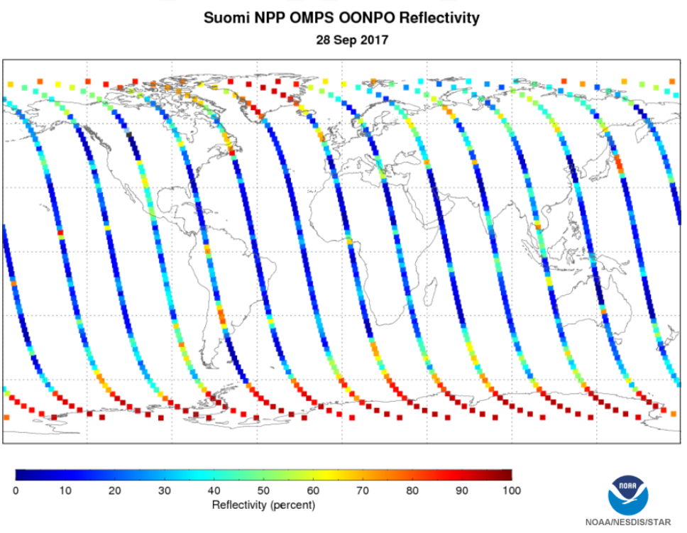 Global example of Suomi NPP OMPS Nadir Profile Ozone Reflectivity on September 28, 2017. Image courtesy of JPSS LTM system.
This dataset contains a high quality operational Environmental Data Record (EDR) of nadir profiler ozone from the Ozone Mapping and Profiling Suite (OMPS) instrument onboard the Suomi-NPP satellite and is produced by the NOAA Environmental Satellite, Data, and Information Service (NESDIS). This global daily product provides estimates of layer ozone amounts, UV reflectivity, and absorbing aerosol index values at a spatial resolution of 50 kilometers at nadir. The EDR also contains quality information including quality flags, measurement sensitivities, and retrieval efficiency factors. The OMPS Nadir Profiler Ozone EDR distributed by the NESDIS Data Exploitation (NDE) system and obtained from the Comprehensive Large-Array Stewardship System (CLASS) are distributed in single 86-second granules in NetCDF-4 format with metadata attributes included.
- Cite as: Flynn, Lawrence, Vaishali, Kapoor, and NOAA JPSS Program Office (2017): NOAA JPSS Ozone Mapping and Profiler Suite (OMPS) Version 8 Nadir Profile Ozone (V8Pro) Environmental Data Record (EDR) from NDE. [indicate subset used]. NOAA National Centers for Environmental Information. [access date].
- gov.noaa.ncdc:C01448
- gov.noaa.class:JPSS_OZONE
C01448
| Download Data |
|
| Order Data |
|
| Distribution Formats |
|
| Ordering Instructions | Contact NCEI for other distribution options and instructions. |
| Distributor | NOAA National Centers for Environmental Information
ncei.info@noaa.gov |
| Dataset Point of Contact | Customer Engagement Branch
DOC/NOAA/NESDIS/NCEI > National Centers for Environmental Information, NESDIS, NOAA, U.S. Department of Commerce ncei.sat.info@noaa.gov |
| Time Period | 2017-09-20 to Present (time interval: 24-hour) |
| Spatial Reference System | urn:ogc:def:crs:EPSG::4326 |
| Spatial Bounding Box Coordinates |
N: 90.0
S: -90.0
E: 180.0
W: -180.0
|
| Spatial Coverage Map | |
| General Documentation |
|
| Processing Documents |
|
| Associated Resources |
|
| Publication Dates |
|
| Edition | Validated |
| Data Presentation Form | Digital image
|
| Dataset Progress Status | Ongoing - data is continually being updated |
| Data Update Frequency | Continual |
| Purpose | OMPS measures total ozone in the atmosphere. In addition, the collection of this data contributes to fulfilling the U.S. treaty obligation to monitor the ozone depletion for the Montreal Protocol to ensure no gaps on ozone coverage. |
| Use Limitations |
|
| Dataset Citation |
|
| Cited Authors |
|
| Principal Investigators |
|
| Resource Providers |
|
| Publishers |
|
| Theme keywords | Global Change Master Directory (GCMD) Science Keywords
|
| Data Center keywords | Global Change Master Directory (GCMD) Data Center Keywords
|
| Platform keywords | Global Change Master Directory (GCMD) Platform Keywords
|
| Instrument keywords | Global Change Master Directory (GCMD) Instrument Keywords
|
| Place keywords | Global Change Master Directory (GCMD) Location Keywords
|
| Project keywords | Global Change Master Directory (GCMD) Project Keywords
|
| Data Resolution keywords | Global Change Master Directory (GCMD) Horizontal Data Resolution Keywords
|
| Stratum keywords | Global Change Master Directory (GCMD) Location Keywords
|
| Use Constraints |
|
| Access Constraints |
|
| Fees |
|
| Lineage Statement | The data were produced by the NOAA Office of Satellite and Product Operations (OSPO) NDE/PDA and are archived at the NOAA National Centers for Environmental Information (NCEI). |
| Processing Steps |
|
| Processing Documents |
|
| Source Datasets |
|
| Processing Steps |
|
Last Modified: 2023-06-23
For questions about the information on this page, please email: ncei.info@noaa.gov