High Definition Geomagnetic Model 2020 Real-Time Disturbance Calculator

browse graphicA map showing the magnetospheric component of the Earth's magnetic field calculated by the HDGM-RT with an inset of a declination line chart from the Honolulu observatory.
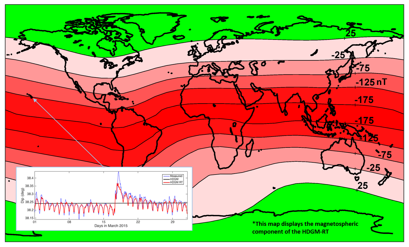
The High Definition Geomagnetic Model (HDGM) is a global, high resolution model of the Earth's geomagnetic main and crustal field, providing magnetic field values (total field, dip, and declination) at any point above or below the Earth's surface. Well planners can use HDGM to compute magnetic reference values at any point, as well as easily integrate HDGM into their directional drilling software. HDGM is updated annually to correctly model secular changes in the geomagnetic field. The US National Oceanic and Atmospheric Administration (NOAA), in partnership with the directional drilling industry and the University of Colorado have developed a real-time component for NOAA's High Definition Geomagnetic Model. HDGM-RT improves the HDGM by accurately modeling the magnetic fields originating in the Earth's magnetosphere in real-time using a combination of solar-wind observing satellites situated between Earth and sun and a chain of geomagnetic observatories on the Earth's surface. The model also includes an ionospheric field model calculated from a combination of observatory and Swarm satellite data in order to represent the daily variations in the ionosphere. The addition of HDGM RT can save rig-time and reduce the drilling cost by enabling improved drill string interference correction during adverse space weather conditions.
  • Cite as: NCEI Geomagnetic Modeling Team. 2019: High Definition Geomagnetic Model 2020 Real-Time Disturbance Calculator. NOAA National Centers for Environmental Information. Accessed [date].
  • NCEI Metadata ID: gov.noaa.ngdc:HDGM2020-RT
gov.noaa.ngdc:HDGM2020-RT
XML
Download Data
  • HDGM2020-RT Home Page (download)
    High Definition Geomagnetic Model (HDGM2020-RT) is sent via secure file transfer protocol
Distribution Formats
  • HDGM2020-RT.zip (Version: 1)
    • File Specification: High Definition Geomagnetic Model (HDGM2020-RT) with Stand-alone Graphical User Interface (GUI) for Windows and C source code. For access to the HDGM-RT, please contact hdgm.support@noaa.gov
Ordering InstructionsContact NCEI for other distribution options and instructions.
DistributorNOAA National Centers for Environmental Information
ncei.info@noaa.gov
Dataset Point of Contact NOAA National Centers for Environmental Information
ncei.info@noaa.gov
Dataset Point of Contact NCEI Geomagnetic Modeling Team
NOAA National Centers for Environmental Information
geomag.models@noaa.gov
Time Period1900-01-01 to 2020-12-31
Spatial Reference Systemurn:ogc:def:crs:EPSG::4326
Spatial Bounding Box Coordinates
N: 90
S: -90
E: 180
W: -180
Spatial Coverage Map
General Documentation
Publication Dates
  • publication: 2019-11-15
Edition1
Data Presentation FormmapDigital
Dataset Progress StatusComplete - production of the data has been completed
Historical archive - data has been stored in an offline storage facility
Data Update Frequency As needed - Associated HDGM2020-RT software may be updated as improvements are created.
PurposeThis data is available to the public for a wide variety of uses including scientific research and analysis.
Use Limitations
  • Produced by the NOAA National Centers for Environmental Information. Not subject to copyright protection within the United States.
Dataset Citation
  • Cite as: NCEI Geomagnetic Modeling Team. 2019: High Definition Geomagnetic Model 2020 Real-Time Disturbance Calculator. NOAA National Centers for Environmental Information. Accessed [date].
Cited Authors
  • NCEI Geomagnetic Modeling Team
Publishers
  • NOAA National Centers for Environmental Information
Theme keywordsGlobal Change Master Directory (GCMD) Science Keywords
  • Earth Science > Solid Earth > Geomagnetism > Magnetic Field
  • Earth Science > Solid Earth > Geomagnetism > Magnetic Intensity
  • Earth Science > Solid Earth > Geomagnetism > Magnetic Declination
  • Earth Science > Solid Earth > Geomagnetism > Magnetic Inclination
Data Center keywordsGlobal Change Master Directory (GCMD) Data Center Keywords
  • DOC/NOAA/NESDIS/NCEI > National Centers for Environmental Information, NESDIS, NOAA, U.S. Department of Commerce
  • DOC/NOAA/NESDIS/NGDC > National Geophysical Data Center, NESDIS, NOAA, U.S. Department of Commerce
Place keywordsGlobal Change Master Directory (GCMD) Location Keywords
  • Geographic Region > Global
Use Constraints
  • Use liability: NOAA and NCEI cannot provide any warranty as to the accuracy, reliability, or completeness of furnished data. Users assume responsibility to determine the usability of these data. The user is responsible for the results of any application of this data for other than its intended purpose.
Access Constraints
  • Distribution liability: NOAA and NCEI make no warranty, expressed or implied, regarding these data, nor does the fact of distribution constitute such a warranty. NOAA and NCEI cannot assume liability for any damages caused by any errors or omissions in these data. If appropriate, NCEI can only certify that the data it distributes are an authentic copy of the records that were accepted for inclusion in the NCEI archives.
Other ConstraintsCite as: NCEI Geomagnetic Modeling Team. 2019: High Definition Geomagnetic Model 2020 Real-Time Disturbance Calculator. NOAA National Centers for Environmental Information. Accessed [date].
Fees
  • The High Definition Geomagnetic Model Real Time Disturbance Field Calculator is available to the public, but requires payment to recoup the cost of model development, custom software creation and testing, as well as customer service efforts. For more information please contact hdgm.support@noaa.gov
Lineage information for: dataset
Processor
  • NOAA National Centers for Environmental Information
  • NOAA National Centers for Environmental Information
  • NOAA National Centers for Environmental Information
  • NOAA National Centers for Environmental Information
  • NOAA National Centers for Environmental Information
Processing Steps
  • The main component of the magnetic field generated by the Earth's core is calculated using data from a number of current and past satellite missions.
  • The component of the magnetic field generated by the Earth's lithosphere is calculated using data from a number of current and past models of the anomaly field of mineral distribution in the Earth's crust. These models are compiled from satellite, observatory, airborne, and marine observations of the Earth's magnetic field
  • The main component of the magnetic field generated by the Earth's lithosphere is converted into spherical harmonic coefficients in order to be combined with the magnetic field intensity and orientation of the Earth's core magnetic field.
  • The magnetic field due to contributions from the ionosphere reacting to space weather.
  • The magnetic field signature from the quiet-time magnetospheric signal and its electromagnetic induction.
Source Datasets
  • Swarm Satellite Data
  • CHAMP Satellite Data
  • DMSP Satellite Data
  • CryoSat Satellite Data
  • Earth Magnetic Anomaly Grid 2 arc-minute resolution (EMAG2)
  • INTERMAGNET Observatory Data
  • WDC Kyoto University Real-time DST
  • USGS Geomagnetism Program: Disturbance Storm-Time (Dst) Index
  • NASA Advanced Composition Explorer (ACE) real-time satellite data
  • >Deep Space Climate Observatory (DSCOVR) real-time satellite data
  • >NOAA SWPC real-time F10.7cm radio emissions
Lineage information for: repository
Processing Steps
  • 2015-04-22T00:00:00 - NOAA created the National Centers for Environmental Information (NCEI) by merging NOAA's National Climatic Data Center (NCDC), National Geophysical Data Center (NGDC), and National Oceanographic Data Center (NODC), including the National Coastal Data Development Center (NCDDC), per the Consolidated and Further Continuing Appropriations Act, 2015, Public Law 113-235. NCEI launched publicly on April 22, 2015.
Last Modified: 2020-05-14
For questions about the information on this page, please email: ncei.info@noaa.gov