NOAA GOES-R Series Advanced Baseline Imager (ABI) Level 2 Aerosol Detection (ADP)
ABI-L2-ADP
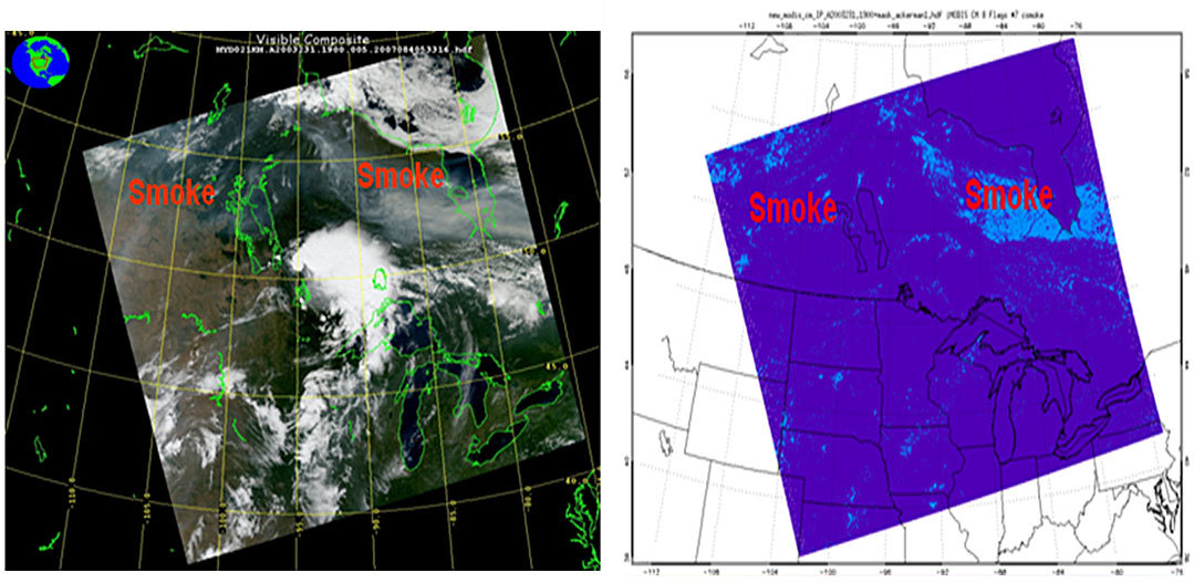 MODIS visible color composite image (left) of a British Columbia, Canada fire event on 19 August 2003 and the resulting smoke flag product generated by the GOES-R Aerosol Detection algorithm (right).
The GOES-R Advanced Baseline Imager (ABI) Aerosol Detection product contains three images in the form of binary masks that identify the presence of aerosols, dust, and smoke. The aerosol mask indicates the presence of either smoke or dust. The dust and smoke masks indicate the presence of dust and smoke, respectively. Because the presence of smoke and dust are independently derived, a given pixel can be identified with both dust and smoke. The product includes data quality information for on-earth pixels. The binary aerosol, dust, and smoke mask values are dimensionless quantities. The Aerosol Detection product images are produced on the ABI fixed grid at 2 km resolution for Full Disk, CONUS and Mesoscale coverage regions from GOES East and West. Product data is produced under the following conditions: Clear sky; Snow-free; Geolocated source data to local zenith angles of 90 degrees and to solar zenith angles of 87 degrees.
- Cite as: GOES-R Algorithm Working Group and GOES-R Series Program, (2017): NOAA GOES-R Series Advanced Baseline Imager (ABI) Level 2 Aerosol Detection (ADP). [indicate subset used]. NOAA National Centers for Environmental Information. [access date].
- doi:
- ABI-L2-ADP
- gov.noaa.ncdc:C01510
- gov.noaa.class:GRABIPRD
C01510
| Download Data |
|
| Order Data |
|
| Distribution Formats |
|
| Ordering Instructions | Contact NCEI for other distribution options and instructions. |
| Distributor | NOAA National Centers for Environmental Information
ncei.info@noaa.gov |
| Dataset Point of Contact | Customer Engagement Branch
DOC/NOAA/NESDIS/NCEI > National Centers for Environmental Information, NESDIS, NOAA, U.S. Department of Commerce ncei.sat.info@noaa.gov |
| Time Period | 2017-12-12 to Present (time interval: 10-minute) |
| Spatial Reference System | urn:ogc:def:crs:EPSG::4326 |
| Spatial Bounding Box Coordinates |
N: 81.3282
S: -81.3282
E: 6.2995
W: -156.2995
|
| Spatial Coverage Map | |
| General Documentation |
|
| Processing Documents |
|
| Associated Resources |
|
| Publication Dates |
|
| Edition | Provisional |
| Data Presentation Form | Digital image
|
| Dataset Progress Status | Ongoing - data is continually being updated |
| Data Update Frequency | Continual |
| Purpose | The Aerosol Detection product will use several spectral bands made available on the GOES-R imager. The algorithm will use known spectral absorption and scattering properties of different aerosols to detect their presence in the atmosphere. The Aerosol Detection product will enable forecasters to better monitor areas of smoke and dust, which can be critical factors in visibility and air quality forecasts. In addition to short-term prediction, this product will also enable better monitoring of the long-term trends in aerosol quantities and distribution throughout the atmosphere. |
| Use Limitations |
|
| Dataset Citation |
|
| Cited Authors |
|
| Principal Investigators |
|
| Resource Providers |
|
| Publishers |
|
| Theme keywords | Global Change Master Directory (GCMD) Science Keywords
|
| Data Center keywords | Global Change Master Directory (GCMD) Data Center Keywords
|
| Platform keywords | Global Change Master Directory (GCMD) Platform Keywords
|
| Instrument keywords | Global Change Master Directory (GCMD) Instrument Keywords
|
| Place keywords | Global Change Master Directory (GCMD) Location Keywords
|
| Project keywords | Global Change Master Directory (GCMD) Project Keywords
|
| Data Resolution keywords | Global Change Master Directory (GCMD) Horizontal Data Resolution Keywords
|
| Stratum keywords | Global Change Master Directory (GCMD) Location Keywords
|
| Use Constraints |
|
| Access Constraints |
|
| Fees |
|
| Lineage Statement | The data were produced by the NOAA Office of Satellite and Product Operations (OSPO) and are archived at the NOAA National Centers for Environmental Information (NCEI). |
| Processor |
|
| Processing Steps |
|
| Processing Documents |
|
| Source Datasets |
|
| Processing Steps |
|
Last Modified: 2023-09-18
For questions about the information on this page, please email: ncei.info@noaa.gov