
Bathymetric data provides insights into the land beneath the water
When humans first began to sail the ocean, they did so without having any idea of what they might find. They began to make maps of the new lands they discovered and, over time, those maps became more precise. But until the 1800s, what lay below the surface of the ocean was still mostly unknown. We now know that beneath the sea surface is an underwater world that contains mountain ranges, trenches, and plains.
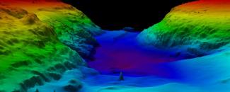
Bathymetry refers to the study of the underwater depths of water bodies, including the ocean, rivers, and lakes. Bathymetric data, collected from a variety of methods, can be used to create bathymetric maps depicting variations in the sea-floor using color and contour lines called depth contours or isobaths. NCEI manages the United States national archive for bathymetric data and holds bathymetric surveys received from sources worldwide. NCEI provides bathymetry data including:
- Coastal Lidar Data Archive
- Marine Trackline Geophysical Data
- National Ocean Service Hydrographic Survey Data
- NOAA Ocean Exploration Data
Bathymetric data provides valuable insights into the underwater world and helps in making informed decisions regarding the sustainable use and protection of our shared marine resources.
Mapping the Global Ocean
While we are learning more about the ocean floor all the time, we still know less about it than we do about the surfaces of Mars or the moon. NCEI is working with global partners to achieve national and international ocean mapping goals.
NCEI hosts the International Hydrographic Organization (IHO) Data Centre for Digital Bathymetry. Discovery and access to these data holdings can be found using the IHO Bathymetric Data Viewer. The viewer also shows the spatial extent of data archived at other repositories such as the European Marine Observation and Data Network (EMODnet) via web services. Earlier this year, NOAA and the IHO signed a Memorandum of Understanding reaffirming NCEI as the host of the Data Center for Digital Bathymetry.
NCEI and the IHO Data Center for Digital Bathymetry also serve as the long-term archive for all raw bathymetric data compiled by the General Bathymetric Chart of the Oceans (GEBCO) Ocean Mapping Program and the Nippon Foundation-GEBCO Seabed 2030 project. GEBCO is a not-for-profit organization with a goal to provide the most authoritative publicly available bathymetry of the world's oceans. It operates under the joint auspices of the IHO and the Intergovernmental Oceanographic Commission (IOC). Seabed 2030 is a global initiative that aspires to create a complete global ocean map by 2030. Seabed 2030 brings data together, identifies the unmapped gaps, and helps coordinate efforts by working with the established ocean mapping community.
NCEI serves as the archive for the IHO's Crowdsourced Bathymetry effort. These data from non-research vessels can be used to supplement the more rigorous and scientific bathymetric coverage undertaken by hydrographic offices, industries, and researchers around the world. Crowdsourced efforts as well as the crowdsourced bathymetry database are poised to become a major source of information for both national and international mapping efforts.
Closer to Shore
In the same way that topographic maps represent the features of dry land, bathymetric maps illustrate terrain that lies underwater. At the coastline, both kinds of maps are important.
A coastal digital elevation model (DEM) depicts Earth’s land surface and seafloor in an integrated digital map of a coastal region. NCEI is an international leader in coastal DEM development. Coastal digital elevation models support a variety of NOAA mission requirements. These include coastal flood forecasts and warnings due to tsunamis, hurricanes, and storm surge, as well as research into fish habitats, sea level changes, and off-shore energy. Accurate coastal DEMs are needed because the shape and depth of the ocean floor affects the speed and height of waves, and coastal land surface height primarily determines the inland extent of flooding.
The Earth TOPOgraphy (ETOPO) 2022 Global Relief Model is a global DEM that integrates topography, bathymetry, and shoreline data to model the contours and features of the entire planet, both above and below sea level. With this Earth model, the characteristics of our world—both land and the ocean floor—become more than two dimensional. ETOPO 2022 provides accurate topographic and bathymetric data to predict water movement across ocean surfaces and over landscapes.
Bathymetric Data Viewer
Bathymetry underpins the safe, sustainable, cost-effective execution of nearly every human activity at sea. It is essential for a wide range of blue economy applications, including navigation safety, marine research, resource exploration, environmental management, and underwater infrastructure planning.
NCEI maintains the National Ocean Service (NOS) hydrographic data and product archive, as well as the Hydrographic Survey Metadata Database (HSMDB). Data and products acquired by the Office of Coast Survey provide coverage of U.S. coastal waters and the exclusive economic zone. NCEI's Marine Trackline Geophysical database provides data on bathymetry, magnetics, gravity, and seismic reflection collected during marine cruises from 1939 to the present. NCEI also provides access to all the bathymetric data collected by NOAA Office of Ocean Exploration and Research, including by the Okeanos Explorer.
NCEI provides access to bathymetric data through the NCEI Bathymetric Data Viewer. The Bathymetric Data Viewer is an interactive map providing discovery, descriptions, and download capability for bathymetric survey data and digital elevation models archived at NCEI. Users can access multibeam, single-beam, lidar, crowdsourced bathymetry data as well as digital elevation models. In addition to the Bathymetric Data Viewer, NCEI promotes bathymetric data discovery access through a variety of tools. By providing this vital bathymetric data, NCEI supports NOAA's mission to understand and predict changes in Earth's environment, as well as conserve and manage coastal and marine resources to meet our nation's economic, social, and environmental needs.


