Stratospheric Water and OzOne Satellite Homogenized (SWOOSH) data set
SWOOSH
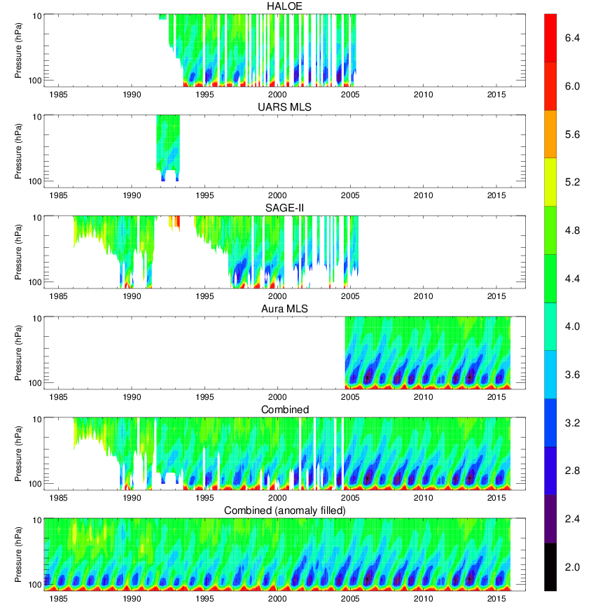 The tropical tape recorder in water vapor
The Stratospheric Water and Ozone Satellite Homogenized (SWOOSH) data set is a merged record of stratospheric ozone and water vapor measurements taken by a number of limb sounding and solar occultation satellites over the previous ~30 years. The SWOOSH record spans 1984 to present, and is comprised of data from the SAGE-II/III, UARS HALOE, UARS MLS, and Aura MLS instruments. The measurements are homogenized by applying corrections that are calculated from data taken during time periods of instrument overlap. The primary SWOOSH data product consists of monthly-mean zonal-mean values on a pressure grid. In addition to the primary (zonal-mean) grid, SWOOSH data are also available on 3D (longitude/latitude/pressure), equivalent latitude, and isentropic grids. The gridded data include the mean, standard deviation, number of observations, and mean uncertainty from each instrument. Also included is a merged (multi-instrument) product based on a weighted mean of the available measurements. Because the merged product contains missing data, a merged and filled product is also provided for (e.g., modeling) studies requiring a continuous dataset.
Dataset Citation
- Cite this data set when used as a source: Davis, Sean; Rosenlof, Karen; NOAA ESRL (2016):Stratospheric Water and OzOne Satellite Homogenized (SWOOSH), Version 2. NOAA National Centers for Environmental Information (NCEI). doi:10.7289/V5TD9VBX [access date]. Publications using this CDR should also cite the following journal article: Davis, S. M., Rosenlof, K. H., Hassler, B., Hurst, D. F., Read, W. G., Vömel, H., Selkirk, H., Fujiwara, M., and Damadeo, R.: The Stratospheric Water and Ozone Satellite Homogenized (SWOOSH) database: a long-term database for climate studies, Earth Syst. Sci. Data, 8, 461-490, doi:10.5194/essd-8-461-2016, 2016
Dataset Identifiers
- doi:10.7289/V5TD9VBX
- NCEI DSI 3699_01
- gov.noaa.ncdc:C00958
ISO 19115-2 Metadata
gov.noaa.ncdc:C00958
| Download Data |
|
| Distribution Formats |
|
| Ordering Instructions | Contact NCEI for other distribution options and instructions. |
| Distributor |
NOAA National Centers for Environmental Information ncei.info@noaa.gov |
| Dataset Point of Contact | Sean Davis DOC/NOAA/OAR/CSD > NOAA OAR Chemical Sciences Division, OAR, NOAA, U.S. Department of Commerce sean.m.davis@noaa.gov |
| Dataset Point of Contact | Customer Engagement Branch NOAA National Centers for Environmental Information 1-828-271-4800 ncei.orders@noaa.gov |
| Time Period | 1984-01-01 to Present (time interval: 1-month) |
| Spatial Bounding Box Coordinates |
West: -180.0
East: 180.0
South: -90.0
North: 90.0
|
| Spatial Coverage Map |
| Dataset Information |
|
| General Documentation |
|
| Associated Resources |
|
| Publication Dates |
|
| Edition | 2 |
| Dataset Progress Status | Ongoing - data is continually being updated |
| Data Update Frequency | Monthly |
| Purpose | This dataset will be used by researchers studying seasonal- to decadal-scale variability in water vapor and ozone concentrations in the stratosphere. |
| Use Limitations |
|
| Dataset Citation |
|
| Cited Authors |
|
| Originators |
|
| Collaborators |
|
| Publishers |
|
| Theme keywords |
Global Change Master Directory (GCMD) Science Keywords
|
| Data Center keywords |
Global Change Master Directory (GCMD) Data Center Keywords
|
| Platform keywords |
Global Change Master Directory (GCMD) Platform Keywords
|
| Instrument keywords |
Global Change Master Directory (GCMD) Instrument Keywords
|
| Place keywords |
Global Change Master Directory (GCMD) Location Keywords
|
| Stratum keywords |
Global Change Master Directory (GCMD) Location Keywords
|
| Use Constraints |
|
| Access Constraints |
|
| Fees |
|
| Lineage information for: dataset | |
|---|---|
| Lineage Statement | SWOOSH contains data from the following satellite instruments: SAGE II (v7), SAGE III (v4), HALOE (v19), UARS MLS (v5 for ozone, v6 for water vapor), and EOS Aura MLS (v4.2). All data are the standard Level 2 retrievals, downloaded from the standard data providers for each instrument. |
| Processor |
|
| Processing Steps |
|
| Processing Environment | Data set created on a Mac OSX system using IDL 8.5. |
| Source Datasets |
|
| Lineage information for: repository | |
|---|---|
| Processing Steps |
|
Last Modified: 2023-06-23
For questions about the information on this page, please email: ncei.info@noaa.gov
For questions about the information on this page, please email: ncei.info@noaa.gov