Archive of Geosample Data and Information from the Columbia University Lamont-Doherty Earth Observatory (LDEO) Lamont-Doherty Core Repository (LDCR)
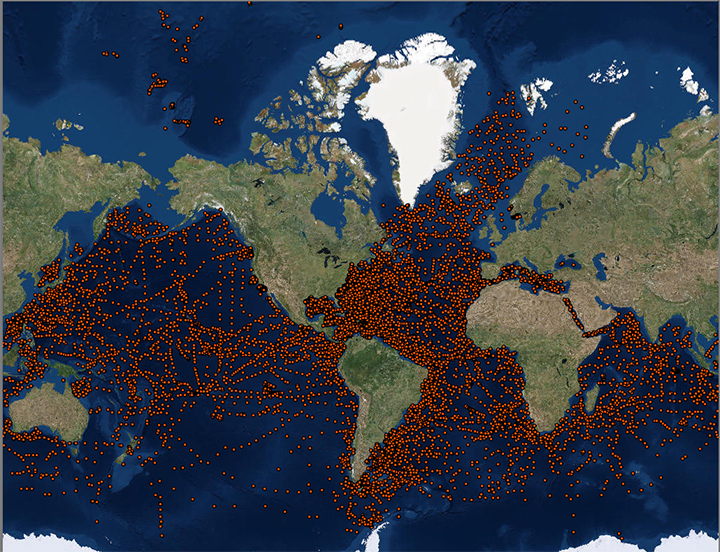 image of sea floor sample locations
The Lamont-Doherty Core Repository (LDCR), operated by the Lamont-Doherty Earth Observatory (LDEO) of Columbia University, is a partner in the Index to Marine and Lacustrine Geological Samples (IMLGS) database, contributing information to the IMLGS to help researchers discover geological samples curated in their facility. The partner repository also sends related data, documents, and imagery to NCEI for long-term archive, but the originating institution is the definitive source of information related to their sample collection. The LDCR contains one of the world's most unique and important collection of scientific samples from the deep sea. Sediment cores from every major ocean and sea are archived at the Core Repository. Materials available through the NCEI archive (other than core metadata) are core photos and descriptions, both of which were done at the time a core was opened; information/photos of what a core is like now are available upon request. If you would like to request material from LDCR holdings or want to know what other services are offered (grain size, coulometry, MST, etc.), please check the LDCR website for more information.
- Cite as: Lamont-Doherty Core Repository (LDCR). 1977: Archive of Geosample Data and Information from the Columbia University Lamont-Doherty Earth Observatory (LDEO) Lamont-Doherty Core Repository (LDCR). NOAA National Centers for Environmental Information. https://doi.org/10.7289/V5M61H7G. Accessed [date].
- doi:10.7289/V5M61H7G
- NCEI Metadata ID: gov.noaa.ngdc.mgg.geology:archived-data_LDEO-sample-repository
gov.noaa.ngdc.mgg.geology:archived-data_LDEO-sample-repository
| Search Data |
-
Map viewer (search)
Open an ArcGIS interactive map interface with the LDEO sample layer active to search and download data from the IMLGS database and access related links.
-
The new IMLGS web application (search)
The new IMLGS web application (2021), which uses a new REST-style API, provides a user interface for querying and displaying the IMLGS data.
-
NOAA GeoPlatform (search)
Access sample information from the IMLGS using the NOAA GeoPlatform.
|
| Download Data |
-
Table View (download)
A table view for searching and exporting data for LDEO samples from the IMLGS database and accessing related links.
|
| Distribution Formats |
- ASCII (Version: UTF-8)
- File Specification: American Standard Code for Information Interchange (ASCII) text format
- JPEG
- File Specification: Joint Photographic Experts Group Image Format
- PDF
- File Specification: Portable Document Format
|
| Ordering Instructions |
Contact NCEI for other distribution options and instructions. |
| Distributor |
NOAA National Centers for Environmental Information
ncei.info@noaa.gov
|
| Dataset Point of Contact |
NOAA National Centers for Environmental Information
ncei.info@noaa.gov
|
| Dataset Point of Contact |
Marine Geology Data Manager
NOAA National Centers for Environmental Information
geology.info@noaa.gov
|
| Dataset Point of Contact |
The Lamont-Doherty Core Repository (LDCR)
Lamont-Doherty Earth Observatory (LDEO) of Columbia University
corelab@ldeo.columbia.edu
|
| Coverage Description |
Global ocean sea floor and lakebeds |
| Time Period |
1936-01-01T00:00:00.000Z to Present |
| Spatial Reference System |
urn:ogc:def:crs:EPSG:4326 |
| Spatial Bounding Box Coordinates |
West: -180.00000
East: 179.91700
South: -66.59330
North: 86.18330
|
| Spatial Coverage Map |
|
| General Documentation |
-
Metadata Landing Page
How to cite this data set (doi:10.7289/V5M61H7G), all access options, and complete documentation
-
Originator's Web page
Documentation about the Lamont-Doherty Core Repository (LCDR) and information on requesting sample material
-
Archived files
Related offline geosample data files in the NCEI long-term archive
|
| Associated Resources |
- Lamont-Doherty Core Repository
- Index to Marine and Lacustrine Geological Samples (IMLGS)
- NCEI Marine Geology Data Archive
-
Parent Archive
Information about the Marine Geology Data Archive at NCEI
- NOAA/NCEI Marine Geology WAF
|
| Publication Dates |
- publication: 1977-12-31
- revision: 2022-05-05
|
| Data Presentation Form |
Digital table - digital representation of facts or figures systematically displayed, especially in columns
|
| Dataset Progress Status |
Ongoing - data is continually being updated
Historical archive - data has been stored in an offline storage facility |
| Data Update Frequency |
Irregular - The repository contributes data to the NCEI archive and to the IMLGS as new samples are added to their collection and/or as new sample data are available for public release. |
| Supplemental Information |
The Lamont-Doherty Core Repository (LDCR) is located in the Core Laboratory at the Lamont-Doherty Earth Observatory in Palisades, New York, approximately 15 miles north of the Columbia University main campus. Sediment cores and dredges from every major world ocean and sea, rivers and lakes, are archived in the Core Repository. A great number of cores in the archives were collected under the directive of Maurice Ewing, Lamont's founder and first director, who insisted that "a core-a-day" be taken whenever a Lamont vessel was at sea. As our ships criss-crossed across the oceans, he felt that one might never again pass over that particular piece of ocean terrain, and the opportunity to core should be taken for future researchers. Our irreplaceable global collection of legacy material is the result of Ewing's vision of a "library" of cores. The Lamont Repository is solely funded by the National Science Foundation Division of Ocean Sciences. Dr. Floyd McCoy, former Curator of the LDCR, lead the group that designed the original IMLGS. |
| Purpose |
The main purpose of the LDCR is to assure that geological samples are properly stored, described, preserved and available for use by qualified investigators from both inside and outside the institution. Data and information are archived at NCEI to promote public access to research results and to increase their discoverability via the IMLGS. |
| Use Limitations |
- Produced by the NOAA National Centers for Environmental Information. Not subject to copyright protection within the United States.
|
| Dataset Citation |
- Cite as: Lamont-Doherty Core Repository (LDCR). 1977: Archive of Geosample Data and Information from the Columbia University Lamont-Doherty Earth Observatory (LDEO) Lamont-Doherty Core Repository (LDCR). NOAA National Centers for Environmental Information. https://doi.org/10.7289/V5M61H7G. Accessed [date].
|
| Cited Authors |
- Lamont-Doherty Core Repository (LDCR)
|
| Originators |
- Nichole Anest
Columbia Climate School, Lamont-Doherty Earth Observatory (LDEO)
|
| Principal Investigators |
- Dr. Maureen Raymo
Columbia Climate School, Lamont-Doherty Earth Observatory (LDEO)
|
| Contributors |
- Ramona Lotti-Bond
Lamont-Doherty Earth Observatory (LDEO)
- Dr. Floyd McCoy
Lamont-Doherty Earth Observatory (LDEO)
|
| Custodians |
- NOAA National Centers for Environmental Information
|
| Sponsors |
- National Science Foundation (NSF)
|
| Points of Contact |
- Nichole Anest
Columbia Climate School, Lamont-Doherty Earth Observatory (LDEO)
|
| Publishers |
- NOAA National Centers for Environmental Information
|
| Acknowledgments |
- The LDCR receives substantial support from the U.S. National Science Foundation.
|
| Theme keywords |
Library of Congress Subject Headings
- Databases
- Scientific archives
- Electronic records
- Oceanography
- Ocean bottom
- Geology
- Submarine geology
- Marine sediments
SeaDataNet Common Vocabularies
- Marine geology
- Rock and sediment lithology and mineralogy
USGS Science Topics- Sea-floor characteristics
USDA National Agricultural Library's Agricultural Thesaurus (NALT)
Global Change Master Directory (GCMD) Science Keywords
- Earth Science > Oceans > Marine Sediments
- Earth Science > Oceans > Marine Sediments > Sediment Composition
- Earth Science > Paleoclimate > Ocean/Lake Records > Sediments
|
| Data Center keywords |
Global Change Master Directory (GCMD) Data Center Keywords
- DOC/NOAA/NESDIS/NCEI > National Centers for Environmental Information, NESDIS, NOAA, U.S. Department of Commerce
- DOC/NOAA/NESDIS/NGDC > National Geophysical Data Center, NESDIS, NOAA, U.S. Department of Commerce
|
| Platform keywords |
Global Change Master Directory (GCMD) Platform Keywords- In Situ Ocean-based Platforms > Ships
|
| Instrument keywords |
Global Change Master Directory (GCMD) Instrument Keywords
- In Situ/Laboratory Instruments > Corers > Coring Devices
- In Situ/Laboratory Instruments > Samplers > Dredging Devices
- In Situ/Laboratory Instruments > Samplers > Grabbers/Traps/Collectors > Grab Samplers
- In Situ/Laboratory Instruments > Corers > Rock Corers
- In Situ/Laboratory Instruments > Corers > Sediment Corers
- In Situ/Laboratory Instruments > Corers > Box Core
- In Situ/Laboratory Instruments > Corers > Gravity Corer
|
| Place keywords |
Global Change Master Directory (GCMD) Location Keywords
- Geographic Region > Global Ocean
- Vertical Location >Sea Floor
- Ocean > Arctic Ocean
- Ocean > Atlantic Ocean
- Ocean > Indian Ocean
- Ocean > Pacific Ocean
- Ocean > Southern Ocean
|
| Project keywords |
Global Change Master Directory (GCMD) Project Keywords- IMLGS > Index to Marine and Lacustrine Geological Samples
Global Change Master Directory (GCMD) Project Keywords- ICSU-WDS > International Council for Science - World Data System
|
| Use Constraints |
- Use liability: NOAA and NCEI cannot provide any warranty as to the accuracy, reliability, or completeness of furnished data. Users assume responsibility to determine the usability of these data. The user is responsible for the results of any application of this data for other than its intended purpose.
- Please consult the Curator before proposing to do research on any sample discovered through the IMLGS or the NCEI archive. LDEO has long had an open-policy toward sample requests from academic researchers world-wide. LDEO requests that material provided not be used for work other than the stated purpose (unless follow-up permission is granted), and that sub-samples of the material not be sent to other investigators (again, unless permission is granted). LDEO also requests that you send an electronic copy of all publications resulting from the use of the requested material. This helps document the importance of the repository to the scientific community and justify the funding LDEO receives.
- While every effort has been made to ensure that these data are accurate and reliable within the limits of the current state of the art, NOAA cannot assume liability for any damages caused by any errors or omissions in the data, nor as a result of the failure of the data to function on a particular system. NOAA makes no warranty, expressed or implied, nor does the fact of distribution constitute such a warranty.
|
| Access Constraints |
- Distribution liability: NOAA and NCEI make no warranty, expressed or implied, regarding these data, nor does the fact of distribution constitute such a warranty. NOAA and NCEI cannot assume liability for any damages caused by any errors or omissions in these data. If appropriate, NCEI can only certify that the data it distributes are an authentic copy of the records that were accepted for inclusion in the NCEI archives.
- Sample metadata and most data/images are available online for free download. Additional, full-resolution images from the offline archive may be available. Contact NCEI for more information.
|
| Other Constraints |
Cite as: Lamont-Doherty Core Repository (LDCR). 1977: Archive of Geosample Data and Information from the Columbia University Lamont-Doherty Earth Observatory (LDEO) Lamont-Doherty Core Repository (LDCR). NOAA National Centers for Environmental Information. https://doi.org/10.7289/V5M61H7G. Accessed [date]. |
| Fees |
- In most cases, electronic downloads of the data are free. However, fees may apply for custom orders, data certifications, copies of analog materials, and data distribution on physical media.
|
| Lineage information for: dataset |
|---|
| Lineage Statement |
Data are received by NCEI on an intermittent basis from the repository. Incoming data are checked for adherence to controlled vocabularies, illegal data types in numeric fields, and out of range latitudes/longitudes. NCEI adds IGSNs/links to related resources, where known, and may perform cursory visual inspection of data for reasonableness, asking the originator for guidance on discrepancies. NCEI informs the originator upon ingest of data to the IMLGS database, after which the originator provides one final quality control using the IMLGS map viewer. Data may also be updated/corrected at any time, at the originator's request. |
| Processor |
- NOAA National Centers for Environmental Information
- NOAA National Centers for Environmental Information / Northern Gulf Institute
|
| Processing Environment |
Native Dataset Environment: database tables with auxiliary text and PDF documents and digital imagery |
| Source Datasets |
- Lamont-Doherty Core Repository (LDCR)
- Description of Source: Every core entering the collection is split, photographed, and described. Information on sediment is logged by interval for lithology; mass properties such as texture and color; structure such as bedding and burrows; composition including carbonate content; paleontology and mineralogy; and nature of any contacts. Dredge descriptions are generally prepared by the principal investigator in charge of the acquisition. Records are kept for each core regarding its sampling history, including name of investigator, date, purpose, core or dredge, intervals, sample size, and publications resulting from use of the material. Databases of physical information, megascopic descriptions, and publications are maintained at the Repository and much of this information is now accessible online including grain size and carbonate analyses (those tests done after about 1997), multi-sensor track runs (GRAPE, P-wave velocity, magnetic susceptibility), and RGB line scan data and images. All of the megascopic descriptions and photographs are digitally archived at NCEI.
|
| Lineage information for: repository |
|---|
| Processing Steps |
- 2015-04-22T00:00:00 - NOAA created the National Centers for Environmental Information (NCEI) by merging NOAA's National Climatic Data Center (NCDC), National Geophysical Data Center (NGDC), and National Oceanographic Data Center (NODC), including the National Coastal Data Development Center (NCDDC), per the Consolidated and Further Continuing Appropriations Act, 2015, Public Law 113-235. NCEI launched publicly on April 22, 2015.
|
| Acquisition Information (collection) |
|---|
| Instrument |
- In Situ/Laboratory Instruments
|
| Platform |
- In Situ Ocean-based Platforms > SHIPS
|
Last Modified: 2022-05-05
For questions about the information on this page, please email:
ncei.info@noaa.gov