Archive of Geosample Data and Information from the University of Rhode Island (URI) Graduate School of Oceanography (GSO), Marine Geological Samples Laboratory (MGSL)
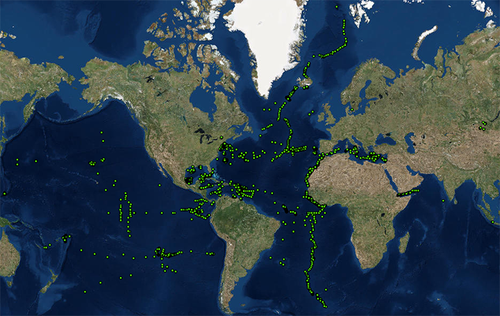 image of sea floor sample locations
The Marine Geological Samples Laboratory (MGSL) of the Graduate School of Oceanography (GSO), University of Rhode Island is a partner in the Index to Marine and Lacustrine Geological Samples (IMLGS) database, contributing information to the IMLGS to help researchers discover geological samples curated in their facility. The partner repository also sends related data, documents, and imagery to NCEI for long-term archive, but the originating institution is the definitive source of information related to their sample collection. The MGSL is a national facility that assists US scientists with marine sample curation and access, and is also the main repository for dredge rocks, deep-sea cores, grabs and land-based geological samples collected by the Marine Geology and Geophysics group at GSO/URI. The MGSL is located on the Narragansett Bay Campus of the University of Rhode Island in Narragansett, R.I. A majority of the funding for curatorial activities in the MGSL is provided by the Ocean Sciences Division of the National Science Foundation.
Dataset Citation
- Cite as: University of Rhode Island (URI) Graduate School of Oceanography (GSO). 1977: Archive of Geosample Data and Information from the University of Rhode Island (URI) Graduate School of Oceanography (GSO), Marine Geological Samples Laboratory (MGSL). NOAA National Centers for Environmental Information. https://doi.org/10.7289/V5JQ0Z0W. Accessed [date].
Dataset Identifiers
- doi:10.7289/V5JQ0Z0W
- NCEI Metadata ID: gov.noaa.ngdc.mgg.geology:archived-data_URI-sample-repository
ISO 19115-2 Metadata
gov.noaa.ngdc.mgg.geology:archived-data_URI-sample-repository
| Search Data |
|
| Download Data |
|
| Distribution Formats |
|
| Ordering Instructions | Contact NCEI for other distribution options and instructions. |
| Distributor |
NOAA National Centers for Environmental Information ncei.info@noaa.gov |
| Dataset Point of Contact |
NOAA National Centers for Environmental Information ncei.info@noaa.gov |
| Dataset Point of Contact | Marine Geology Data Manager NOAA National Centers for Environmental Information geology.info@noaa.gov |
| Dataset Point of Contact | Marine Geological Samples Laboratory (MGSL) University of Rhode Island, Graduate School of Oceanography mgsl@etal.uri.edu |
| Coverage Description | Global ocean sea floor and lakebeds |
| Time Period | 1956-01-01T00:00:00.000Z to Present |
| Spatial Reference System | urn:ogc:def:crs:EPSG:4326 |
| Spatial Bounding Box Coordinates |
West: -177.65000
East: 173.33303
South: -52.45000
North: 79.38000
|
| Spatial Coverage Map |
| General Documentation |
|
| Associated Resources |
|
| Publication Dates |
|
| Data Presentation Form | Digital table - digital representation of facts or figures systematically displayed, especially in columns |
| Dataset Progress Status | Ongoing - data is continually being updated Historical archive - data has been stored in an offline storage facility |
| Data Update Frequency | Irregular - URI contributes data to the NCEI archive and to the IMLGS as new samples are added to the MGSL collection and/or as new sample data are available for public release. |
| Supplemental Information | The Marine Geological Samples Laboratory (MGSL) is located on the University of Rhode Island’s Narragansett Bay Campus. The facility contains storage space for the curation of marine geological samples, including sediment cores, surface sediment grabs, dredge rocks, ROV/HOV grabs, and subaerial deposits of ocean island and arc volcanoes, in addition to housing support laboratories and teaching/outreach spaces. Our collections span the global ocean basins, and provide a library of resources for ongoing and future marine geological research. Support laboratories provide equipment and space for coarse and fine rock preparation, description, and subsampling, and for sediment core splitting, imaging, description, and subsampling. We partner with E/V Nautilus and the URI/GSO Inner Space Center in developing education and outreach activities, and actively teach OCG540: Geological Oceanography using facility labs and samples. The IMLGS contains a subset of summary metadata from the institutional database. The MGSL repository is funded by the National Science Foundation Division of Ocean Sciences, with additional support from the University of Rhode Island. |
| Purpose | The main purpose of the MGSL is to assure that geological samples are properly stored, described, preserved and available for use by qualified investigators from both inside and outside the institution. Data and information are archived at NCEI to promote public access to research results and to increase their discoverability via the IMLGS. |
| Use Limitations |
|
| Dataset Citation |
|
| Cited Authors |
|
| Originators |
|
| Custodians |
|
| Sponsors |
|
| Publishers |
|
| Acknowledgments |
|
| Theme keywords |
Library of Congress Subject Headings
|
| Data Center keywords |
Global Change Master Directory (GCMD) Data Center Keywords
|
| Platform keywords |
Global Change Master Directory (GCMD) Platform Keywords
|
| Instrument keywords |
Global Change Master Directory (GCMD) Instrument Keywords
|
| Place keywords |
Global Change Master Directory (GCMD) Location Keywords
|
| Project keywords |
Global Change Master Directory (GCMD) Project Keywords
|
| Use Constraints |
|
| Access Constraints |
|
| Other Constraints | Cite as: University of Rhode Island (URI) Graduate School of Oceanography (GSO). 1977: Archive of Geosample Data and Information from the University of Rhode Island (URI) Graduate School of Oceanography (GSO), Marine Geological Samples Laboratory (MGSL). NOAA National Centers for Environmental Information. https://doi.org/10.7289/V5JQ0Z0W. Accessed [date]. |
| Fees |
|
| Lineage information for: dataset | |
|---|---|
| Lineage Statement | Data are received by NCEI on an intermittent basis from the repository. Incoming data are checked for adherence to controlled vocabularies, illegal data types in numeric fields, and out of range latitudes/longitudes. NCEI adds IGSNs/links to related resources, where known, and may perform cursory visual inspection of data for reasonableness, asking the originator for guidance on discrepancies. NCEI informs the originator upon ingest of data to the IMLGS database, after which the originator provides one final quality control using the IMLGS map viewer. Data may also be updated/corrected at any time, at the originator's request. |
| Processor |
|
| Processing Environment | Native Dataset Environment: database tables with auxiliary text and PDF documents and digital imagery. |
| Source Datasets |
|
| Lineage information for: repository | |
|---|---|
| Processing Steps |
|
| Acquisition Information (collection) | |
|---|---|
| Instrument |
|
| Platform |
|
Last Modified: 2022-03-04
For questions about the information on this page, please email: ncei.info@noaa.gov
For questions about the information on this page, please email: ncei.info@noaa.gov