Archive of Geosample Data and Information from the Woods Hole Oceanographic Institution (WHOI) Seafloor Samples Laboratory
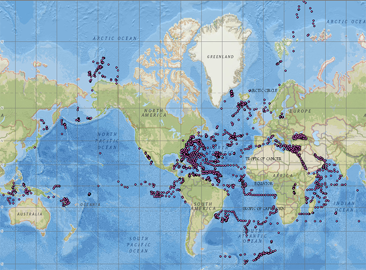 image of sea floor sample locations
The Woods Hole Oceanographic Institution (WHOI) Seafloor Samples Laboratory is a partner in the Index to Marine and Lacustrine Geological Samples (IMLGS) database, contributing information to the IMLGS to help researchers discover geological samples curated in their facility. The partner repository may also send related data, documents, and imagery to NCEI for long-term archive, but the originating institution is the definitive source of information related to their sample collection. The WHOI Seafloor Samples Laboratory receives funding from the US National Science Foundation and is located in the McLean Laboratory on WHOI's Quissett Campus.
- Cite as: Woods Hole Oceanographic Institution (WHOI) Seafloor Samples Laboratory. 1977: Archive of Geosample Data and Information from the Woods Hole Oceanographic Institution (WHOI) Seafloor Samples Laboratory. NOAA National Centers for Environmental Information. https://doi.org/10.7289/V5WH2N0Z. Accessed [date].
- doi:10.7289/V5WH2N0Z
- NCEI Metadata ID: gov.noaa.ngdc.mgg.geology:archived-data_WHOI-sample-repository
gov.noaa.ngdc.mgg.geology:archived-data_WHOI-sample-repository
| Search Data |
-
Map viewer (search)
Open an ArcGIS interactive map interface with the WHOI sample layer active, to search and download data from the IMLGS database and access related links.
-
Linked data interface (search)
Offsite Linked Data interface (RDF graph) for Semantic Web access to the database, offered cooperatively on the Rolling Deck to Repository (R2R) server.
-
Open Data ArcGIS interface (search)
Access sample information from the IMLGS using the Open Data ArcGIS interface enabling filtering, sorting, and export in multiple formats
|
| Download Data |
-
Web forms interface (download)
Text interface to search and download data for WHOI samples from the IMLGS database and access related links.
|
| Distribution Formats |
- ASCII (Version: UTF-8)
- File Specification: American Standard Code for Information Interchange (ASCII) text format.
- JPEG
- KML
- File Specification: Keyhole Markup Language File
- PDF
- File Specification: Portable Document Format
|
| Ordering Instructions |
Contact NCEI for other distribution options and instructions. |
| Distributor |
NOAA National Centers for Environmental Information
ncei.info@noaa.gov
|
| Dataset Point of Contact |
NOAA National Centers for Environmental Information
ncei.info@noaa.gov
|
| Dataset Point of Contact |
Marine Geology Data Manager
NOAA National Centers for Environmental Information
geology.info@noaa.gov
|
| Coverage Description |
Global ocean sea floor and lakebeds |
| Time Period |
1957-11-02T00:00:00.000Z to 2013-06-11T00:00:00.000Z |
| Spatial Reference System |
urn:ogc:def:crs:EPSG:4326 |
| Spatial Bounding Box Coordinates |
West: -179.7996
East: 178.81667
South: -59.7483
North: 84.95407
|
| Spatial Coverage Map |
|
| General Documentation |
-
Metadata Landing Page
How to cite this data set (doi:10.7289/V5WH2N0Z), all access options, and complete documentation.
-
Originator's Web page
Documentation about the Woods Hole Oceanographic Institution (WHOI) Seafloor Samples Laboratory and information on requesting sample material.
-
Archived files
Related offline geosample data files in the NCEI long-term archive
|
| Associated Resources |
- WHOI Seafloor Samples Laboratory
- Index to Marine and Lacustrine Geological Samples (IMLGS)
-
Parent Database
The parent IMLGS database contains more/related data and information.
- NCEI Marine Geology Data Archive
-
Parent Archive
Information about the Marine Geology Data Archive at NCEI.
- NOAA/NCEI Marine Geology WAF
|
| Publication Dates |
- publication: 1977-12-31
- revision: 2015-09-23
|
| Data Presentation Form |
Digital table - digital representation of facts or figures systematically displayed, especially in columns
|
| Dataset Progress Status |
Ongoing - data is continually being updated
Historical archive - data has been stored in an offline storage facility |
| Data Update Frequency |
Irregular - The repository contributes data to the NCEI archive and to the IMLGS as new samples are added to their collection, as resources allow. |
| Supplemental Information |
Additonal related data and information are available directly from the contributing institution, which is the authoritative and most current source of data and information related to their sample collection. The IMLGS contains a subset of summary metadata from the institutional database. Dr. David Johnson, former Curator of the WHOI SSL participated in design of the original Index to Marine and Lacustrine Geological Samples database. |
| Purpose |
Information about the WHOI geosample collection is archived at NCEI to promote public access to research results and to increase their discoverability via the IMLGS. |
| Use Limitations |
- Produced by the NOAA National Centers for Environmental Information. Not subject to copyright protection within the United States.
|
| Dataset Citation |
- Cite as: Woods Hole Oceanographic Institution (WHOI) Seafloor Samples Laboratory. 1977: Archive of Geosample Data and Information from the Woods Hole Oceanographic Institution (WHOI) Seafloor Samples Laboratory. NOAA National Centers for Environmental Information. https://doi.org/10.7289/V5WH2N0Z. Accessed [date].
|
| Cited Authors |
- Woods Hole Oceanographic Institution (WHOI) Seafloor Samples Laboratory
|
| Originators |
- James Broda
Woods Hole Oceanographic Institution, Department of Geology and Geophysics Core Repository
- Ellen Roosen
Woods Hole Oceanographic Institution, Department of Geology and Geophysics Core Repository
- Mr. Alan Driscoll
Woods Hole Oceanographic Institution (WHOI)
- Dr. Dave Johnson
Woods Hole Oceanographic Institution (WHOI)
|
| Custodians |
- NOAA National Centers for Environmental Information
|
| Sponsors |
- National Science Foundation (NSF)
|
| Publishers |
- NOAA National Centers for Environmental Information
|
| Acknowledgments |
- The WHOI Seafloor Samples Laboratory receives substantial support from the U.S. National Science Foundation.
|
| Theme keywords |
Library of Congress Subject Headings
- Databases
- Scientific archives
- Electronic records
- Oceanography
- Ocean bottom
- Geology
- Submarine geology
- Marine sediments
SeaDataNet Common Vocabularies
- Marine geology
- Rock and sediment lithology and mineralogy
USGS Science Topics- Sea-floor characteristics
USDA National Agricultural Library's Agricultural Thesaurus (NALT)
Global Change Master Directory (GCMD) Science Keywords
- Earth Science > Oceans > Marine Sediments
- Earth Science > Oceans > Marine Sediments > Sediment Composition
- Earth Science > Paleoclimate > Ocean/Lake Records > Sediments
|
| Data Center keywords |
Global Change Master Directory (GCMD) Data Center Keywords
- DOC/NOAA/NESDIS/NCEI > National Centers for Environmental Information, NESDIS, NOAA, U.S. Department of Commerce
- DOC/NOAA/NESDIS/NGDC > National Geophysical Data Center, NESDIS, NOAA, U.S. Department of Commerce
|
| Platform keywords |
Global Change Master Directory (GCMD) Platform Keywords- In Situ Ocean-based Platforms > Ships
|
| Instrument keywords |
Global Change Master Directory (GCMD) Instrument Keywords
- In Situ/Laboratory Instruments > Corers > Coring Devices
- In Situ/Laboratory Instruments > Samplers > Dredging Devices
- In Situ/Laboratory Instruments > Samplers > Grabbers/Traps/Collectors > Grab Samplers
- In Situ/Laboratory Instruments > Corers > ROCK CORERS
- In Situ/Laboratory Instruments > Corers > Sediment Corers
|
| Place keywords |
Global Change Master Directory (GCMD) Location Keywords
- Geographic Region > Global Ocean
- Vertical Location >Sea Floor
- Ocean > Arctic Ocean
- Ocean > Atlantic Ocean
- Ocean > Indian Ocean
- Ocean > Pacific Ocean
- Ocean > Southern Ocean
|
| Project keywords |
Global Change Master Directory (GCMD) Project Keywords
Global Change Master Directory (GCMD) Project Keywords- ICSU-WDS > International Council for Science - World Data System
|
| Use Constraints |
- Use liability: NOAA and NCEI cannot provide any warranty as to the accuracy, reliability, or completeness of furnished data. Users assume responsibility to determine the usability of these data. The user is responsible for the results of any application of this data for other than its intended purpose.
- Please consult the Curator before proposing to do research on any sample discovered through the IMLGS or the NCEI archive.
- While every effort has been made to ensure that these data are accurate and reliable within the limits of the current state of the art, NOAA cannot assume liability for any damages caused by any errors or omissions in the data, nor as a result of the failure of the data to function on a particular system. NOAA makes no warranty, expressed or implied, nor does the fact of distribution constitute such a warranty.
|
| Access Constraints |
- Distribution liability: NOAA and NCEI make no warranty, expressed or implied, regarding these data, nor does the fact of distribution constitute such a warranty. NOAA and NCEI cannot assume liability for any damages caused by any errors or omissions in these data. If appropriate, NCEI can only certify that the data it distributes are an authentic copy of the records that were accepted for inclusion in the NCEI archives.
- Sample metadata and most data/images are available online for free download. Additional, full-resolution images from the offline archive may be available. Contact NCEI for more information.
|
| Other Constraints |
Cite as: Woods Hole Oceanographic Institution (WHOI) Seafloor Samples Laboratory. 1977: Archive of Geosample Data and Information from the Woods Hole Oceanographic Institution (WHOI) Seafloor Samples Laboratory. NOAA National Centers for Environmental Information. https://doi.org/10.7289/V5WH2N0Z. Accessed [date]. |
| Fees |
- In most cases, electronic downloads of the data are free. However, fees may apply for custom orders, data certifications, copies of analog materials, and data distribution on physical media.
|
| Lineage information for: dataset |
|---|
| Lineage Statement |
Data are received by NCEI on an intermittent basis from the repository. Incoming data are checked for adherence to controlled vocabularies, illegal data types in numeric fields, and out of range latitudes/longitudes. NCEI adds IGSNs/links to related resources, where known, and may perform cursory visual inspection of data for reasonableness, asking the originator for guidance on discrepancies. Preliminary processed data are placed in a test database for inspection by the originator, and iteratively corrected until the originator approves their publication to the production database. Data may also be updated/corrected at any time, at the originator's request. |
| Processor |
- NOAA National Centers for Environmental Information
|
| Processing Environment |
Native Dataset Environment: database tables with auxiliary text and PDF documents and digital imagery. |
| Source Datasets |
- WHOI SedCore 2000 database
- Description of Source: Metadata describing the WHOI sample holdings contributed to the IMLGS are a subset of more extensive data maintained in the WHOI SedCore 2000 database. Additonal related data and information are available directly from the contributing institution, which is the authoritative and most current source of data and information related to their sample collection.
|
| Lineage information for: repository |
|---|
| Processing Steps |
- 2015-04-22T00:00:00 - NOAA created the National Centers for Environmental Information (NCEI) by merging NOAA's National Climatic Data Center (NCDC), National Geophysical Data Center (NGDC), and National Oceanographic Data Center (NODC), including the National Coastal Data Development Center (NCDDC), per the Consolidated and Further Continuing Appropriations Act, 2015, Public Law 113-235. NCEI launched publicly on April 22, 2015.
|
| Acquisition Information (collection) |
|---|
| Instrument |
- In Situ/Laboratory Instruments
|
| Platform |
- In Situ Ocean-based Platforms > SHIPS
|
Last Modified: 2020-04-21
For questions about the information on this page, please email:
ncei.info@noaa.gov