Marine Trackline Geophysical Database
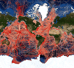 Map showing a web mercator projection of the trackline web map data discovery portal.
This data set contains bathymetry, magnetic, gravity and seismic shot point navigation data collected during marine cruises from 1939 to the present. Coverage is worldwide. These data are stored in the MGD77 exchange format and are available for download in a variety of user selectable formats. One Header record and multiple Data records are available for a particular cruise/leg (port to port operation). The Header record documents both the content and the structure of the subsequent Data records, containing that part of the data that remains invariant throughout the cruise. The Data records present geophysical data (bathymetry, magnetics and gravity) and seismic information (shot-point identification) with a corresponding time and position. Documentation that varies within the cruise is also included with the data records. Data are fully searchable on-line by geographic area, year of cruise, institution, platform, cruise, date or data type.
Dataset Citation
- Cite as: NOAA National Geophysical Data Center. 1977: Marine Trackline Geophysical Database. NOAA National Centers for Environmental Information. https://doi.org/doi:10.7289/V5CZ35DR. Accessed [date].
Dataset Identifiers
- doi:10.7289/V5CZ35DR
- NCEI Metadata ID: gov.noaa.ngdc:G00129
ISO 19115-2 Metadata
gov.noaa.ngdc:G00129
| Search Data |
|
| Distribution Formats |
|
| Ordering Instructions | Ordering Instructions: Trackline data can be obtained by visiting the Geophysical Survey Data Viewer. The user must then select the desired parameters (bathymetry, magnetics, gravity or seismic) and any other applicable filters. The user is then able to get all of the data that fit this criteria (within certain size limits) or may further refine their request by designating an area of interest. The user is then taken to a landing page where they can further refine the data that they would like to be delivered, format, and any other data that is available. The user then provides an email address where the user will be informed when their data package is available for download. |
| Distributor |
NOAA National Centers for Environmental Information ncei.info@noaa.gov |
| Dataset Point of Contact |
NOAA National Centers for Environmental Information ncei.info@noaa.gov |
| Dataset Point of Contact | Trackline Team NOAA National Centers for Environmental Information trackline.info@noaa.gov |
| Time Period | 1939-01-01 to Present |
| Spatial Reference System | Through the collection reference systems have vaired with time and location. Please see survey level metadata for detailed information. |
| Spatial Bounding Box Coordinates |
West: -180.00
East: 180.00
South: -90.00
North: 90.00
|
| Spatial Coverage Map |
| General Documentation |
|
| Publication Dates |
|
| Dataset Progress Status | Complete - production of the data has been completed Historical archive - data has been stored in an offline storage facility |
| Data Update Frequency | Irregular |
| Purpose | Marine Research and Commercial Exploration |
| Use Limitations |
|
| Dataset Citation |
|
| Cited Authors |
|
| Originators |
|
| Custodians |
|
| Publishers |
|
| Theme keywords |
Global Change Master Directory (GCMD) Science Keywords
|
| Data Center keywords |
Global Change Master Directory (GCMD) Data Center Keywords
|
| Place keywords |
Global Change Master Directory (GCMD) Location Keywords
|
| Project keywords |
Global Change Master Directory (GCMD) Project Keywords
|
| Use Constraints |
|
| Access Constraints |
|
| Other Constraints | Cite as: NOAA National Geophysical Data Center. 1977: Marine Trackline Geophysical Database. NOAA National Centers for Environmental Information. https://doi.org/doi:10.7289/V5CZ35DR. Accessed [date]. |
| Fees |
|
| Lineage information for: dataset | |
|---|---|
| Source Datasets | |
| Lineage information for: repository | |
|---|---|
| Processing Steps |
|
| Acquisition Information (collection) | |
|---|---|
| Instrument |
|
Last Modified: 2023-09-15
For questions about the information on this page, please email: ncei.info@noaa.gov
For questions about the information on this page, please email: ncei.info@noaa.gov