Water temperature, salinity, and current velocity collected at mooring S1 in the Amundsen Sea from 2010-02-15 to 2016-01-17 (NCEI Accession 0211128)
 Preview graphic
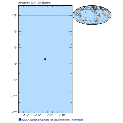
This dataset contains water temperature, salinity, and current velocity from multi-year mooring placed in the Getz-Dotson trough in the Amundsen Sea, on the West Antarctic continental shelf during 2010-2016. The mooring was placed in the same position between 2010 and 2020 (turning the mooring over every 1 or 2 years). There is a gap between 2016 - 2018, when the mooring had gone missing. Temperature and salinity was recorded all years on at least 5 points in the water column. Velocity was recorded most years. Data are in text format.
- Cite as: Wåhlin, Anna K.; Arneborg, Lars; Assman, Karen M.; Kalén, Ola; Melin, Marcus; Rolandsson, Johan; Stranne, Christian (2020). Water temperature, salinity, and current velocity collected at mooring S1 in the Amundsen Sea from 2010-02-15 to 2016-01-17 (NCEI Accession 0211128). [indicate subset used]. NOAA National Centers for Environmental Information. Dataset. https://www.ncei.noaa.gov/archive/accession/0211128. Accessed [date].
| Time Period |
2010-02-15 to 2016-01-17 |
| Spatial Bounding Box Coordinates |
West: -116.3521
East: -116.346
South: -72.4569
North: -72.45
|
| Spatial Coverage Map |
|
| Publication Dates |
|
| Data Presentation Form |
Digital table - digital representation of facts or figures systematically displayed, especially in columns
|
| Dataset Progress Status |
Complete - production of the data has been completed
Historical archive - data has been stored in an offline storage facility |
| Data Update Frequency |
As needed |
| Supplemental Information |
Submission Package ID: FXC6WX |
| Purpose |
These data were collected to support the Southern Ocean Observing System (SOOS), www.soos.aq |
| Use Limitations |
- Distribution liability: NOAA and NCEI make no warranty, expressed or implied, regarding these data, nor does the fact of distribution constitute such a warranty. NOAA and NCEI cannot assume liability for any damages caused by any errors or omissions in these data. If appropriate, NCEI can only certify that the data it distributes are an authentic copy of the records that were accepted for inclusion in the NCEI archives.
|
| Dataset Citation |
- Cite as: Wåhlin, Anna K.; Arneborg, Lars; Assman, Karen M.; Kalén, Ola; Melin, Marcus; Rolandsson, Johan; Stranne, Christian (2020). Water temperature, salinity, and current velocity collected at mooring S1 in the Amundsen Sea from 2010-02-15 to 2016-01-17 (NCEI Accession 0211128). [indicate subset used]. NOAA National Centers for Environmental Information. Dataset. https://www.ncei.noaa.gov/archive/accession/0211128. Accessed [date].
|
| Cited Authors |
|
| Principal Investigators |
|
| Contributors |
|
| Resource Providers |
|
| Publishers |
|
| Theme keywords |
NODC DATA TYPES THESAURUS
NODC OBSERVATION TYPES THESAURUS
WMO_CategoryCode
Global Change Master Directory (GCMD) Science Keywords
|
| Data Center keywords |
NODC COLLECTING INSTITUTION NAMES THESAURUS
NODC SUBMITTING INSTITUTION NAMES THESAURUS
Global Change Master Directory (GCMD) Data Center Keywords
|
| Platform keywords |
NODC PLATFORM NAMES THESAURUS
ICES/SeaDataNet Ship Codes
|
| Instrument keywords |
NODC INSTRUMENT TYPES THESAURUS
Global Change Master Directory (GCMD) Instrument Keywords
|
| Place keywords |
NODC SEA AREA NAMES THESAURUS
Global Change Master Directory (GCMD) Location Keywords
|
| Keywords |
NCEI ACCESSION NUMBER
|
| Use Constraints |
- Cite as: Wåhlin, Anna K.; Arneborg, Lars; Assman, Karen M.; Kalén, Ola; Melin, Marcus; Rolandsson, Johan; Stranne, Christian (2020). Water temperature, salinity, and current velocity collected at mooring S1 in the Amundsen Sea from 2010-02-15 to 2016-01-17 (NCEI Accession 0211128). [indicate subset used]. NOAA National Centers for Environmental Information. Dataset. https://www.ncei.noaa.gov/archive/accession/0211128. Accessed [date].
|
| Access Constraints |
- Use liability: NOAA and NCEI cannot provide any warranty as to the accuracy, reliability, or completeness of furnished data. Users assume responsibility to determine the usability of these data. The user is responsible for the results of any application of this data for other than its intended purpose.
|
| Fees |
- In most cases, electronic downloads of the data are free. However, fees may apply for custom orders, data certifications, copies of analog materials, and data distribution on physical media.
|
| Lineage information for: dataset |
|---|
| Processing Steps |
- 2020-07-13T21:49:26Z - NCEI Accession 0211128 v1.1 was published.
|
| Output Datasets |
- NCEI Accession 0211128 v1.1
|
| Lineage information for: dataset |
|---|
| Processing Steps |
- Parameter or Variable: WATER TEMPERATURE (measured); Units: degrees C; Observation Category: in situ; Sampling Instrument: mooring; Sampling and Analyzing Method: Microcat SBE37; Data Quality Method: Intercalibrated with ship-born CTD and corrected Checked for drifts, removed outliers, hourly averages.
- Parameter or Variable: SALINITY (measured); Units: psu; Observation Category: in situ; Sampling Instrument: mooring; Sampling and Analyzing Method: Microcat SBE37; Data Quality Method: Intercalibrated with ship-born CTD and corrected Checked for drifts, removed outliers, hourly averages.
- Parameter or Variable: CURRENT SPEED - NORTH/SOUTH COMPONENT (V) (measured); Units: m/s; Observation Category: in situ; Sampling Instrument: ADCP; Sampling and Analyzing Method: Moored (bottom mounted) ADCP; Data Quality Method: Quality control performed using standard criteria for filtering out bad data and outliers* based on quality controls on individual beams and bins recorded by the instrument each ping (percent good returns below 50%, average echo intensity below 40 (counts) and roll and pitch of instrument exceeding 20 degrees filtered out) *Taylor, J. A. & Jonas, A. M. Maximising Data Return: Towards a quality control strategy for Managing and Processing TRDI ADCP Data Sets from Moored Instrumentation. in 2008 IEEE/OES 9th Working Conference on Current Measurement Technology 80–88 (IEEE, 2008). doi:10.1109/CCM.2008.4480848.
- Parameter or Variable: CURRENT SPEED - EAST/WEST COMPONENT (U) (measured); Units: m/s; Observation Category: in situ; Sampling Instrument: ADCP; Sampling and Analyzing Method: Quality control performed using standard criteria for filtering out bad data and outliers* based on quality controls on individual beams and bins recorded by the instrument each ping (percent good returns below 50%, average echo intensity below 40 (counts) and roll and pitch of instrument exceeding 20 degrees filtered out) *Taylor, J. A. & Jonas, A. M. Maximising Data Return: Towards a quality control strategy for Managing and Processing TRDI ADCP Data Sets from Moored Instrumentation. in 2008 IEEE/OES 9th Working Conference on Current Measurement Technology 80–88 (IEEE, 2008). doi:10.1109/CCM.2008.4480848.
- Parameter or Variable: HYDROSTATIC PRESSURE (measured); Units: dbar; Observation Category: in situ; Sampling Instrument: mooring; Sampling and Analyzing Method: Microcat; Data Quality Method: Checked for drifts, removed outliers, hourly averages.
|
| Acquisition Information (collection) |
|---|
| Instrument |
|
| Platform |
|
Last Modified: 2022-10-20T14:18:29Z
For questions about the information on this page, please email:
ncei.info@noaa.gov




