Sea Ice Pressure Ridge Sail Height, Arctic, 2010-2018 (NCEI Accession 0202018)
 Preview graphic
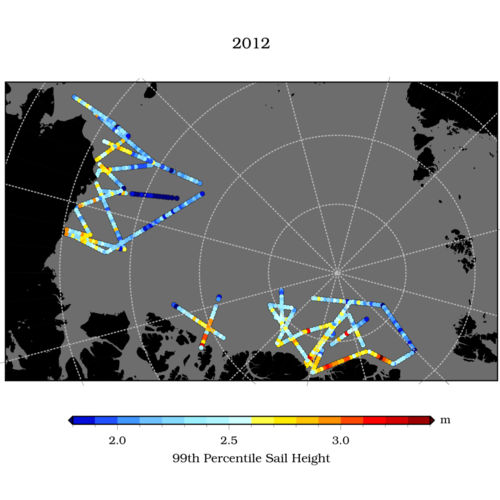
The Sail height data is derived from high-resolution Digital Mapping System imagery acquired in the late winter months of March, April, and May during NASA's annual Operation IceBridge airborne campaigns in the Arctic. Pressure-ridge sail-height is defined as the height of the ridge sail above the sea ice surface. Statistics describing pressure ridge sails are extracted per image. Arithmetic averages are computed for 25 km along-track segments for each aircraft flight line, in the absence of clouds, polar darkness and sea ice leads.
- Cite as: Duncan, Kyle; Farrell, Sinead; Connor, Laurence; Richter-Menge, Jacqueline; Hutchings, Jennifer; Dominguez, Roseanne (2019). Sea Ice Pressure Ridge Sail Height, Arctic, 2010-2018 (NCEI Accession 0202018). [indicate subset used]. NOAA National Centers for Environmental Information. Dataset. https://doi.org/10.25921/5j49-x434. Accessed [date].
| Time Period |
2010-03-23 to 2018-04-16 |
| Spatial Bounding Box Coordinates |
West: -180
East: 180
South: 65
North: 90
|
| Spatial Coverage Map |
|
| Publication Dates |
|
| Data Presentation Form |
Digital table - digital representation of facts or figures systematically displayed, especially in columns
|
| Dataset Progress Status |
Complete - production of the data has been completed
Historical archive - data has been stored in an offline storage facility |
| Data Update Frequency |
As needed |
| Supplemental Information |
Submission Package ID: BL0UWL |
| Purpose |
This dataset is available to the public for a wide variety of uses including scientific research and analysis. |
| Use Limitations |
- Distribution liability: NOAA and NCEI make no warranty, expressed or implied, regarding these data, nor does the fact of distribution constitute such a warranty. NOAA and NCEI cannot assume liability for any damages caused by any errors or omissions in these data. If appropriate, NCEI can only certify that the data it distributes are an authentic copy of the records that were accepted for inclusion in the NCEI archives.
|
| Dataset Citation |
- Cite as: Duncan, Kyle; Farrell, Sinead; Connor, Laurence; Richter-Menge, Jacqueline; Hutchings, Jennifer; Dominguez, Roseanne (2019). Sea Ice Pressure Ridge Sail Height, Arctic, 2010-2018 (NCEI Accession 0202018). [indicate subset used]. NOAA National Centers for Environmental Information. Dataset. https://doi.org/10.25921/5j49-x434. Accessed [date].
|
| Cited Authors |
|
| Principal Investigators |
|
| Collaborators |
|
| Contributors |
|
| Resource Providers |
|
| Points of Contact |
|
| Publishers |
|
| Theme keywords |
NODC DATA TYPES THESAURUS
NODC OBSERVATION TYPES THESAURUS
WMO_CategoryCode
Global Change Master Directory (GCMD) Science Keywords
Provider Keywords
- DMS First Image Filename
- DMS Last Image Filename
- Maximum sail height
- Mean sail height
- Modal sail height
- Number of Images
- Number of sail height measurements
- Sail height 25th percentile
- Sail height 5th percentile
- Sail height 75th percentile
- Sail height 95th percentile
- Sail height 99th percentile
- Sail height standard deviation
- Time
- high-resolution optical imagery
|
| Data Center keywords |
NODC COLLECTING INSTITUTION NAMES THESAURUS
NODC SUBMITTING INSTITUTION NAMES THESAURUS
Global Change Master Directory (GCMD) Data Center Keywords
|
| Platform keywords |
NODC PLATFORM NAMES THESAURUS
ICES/SeaDataNet Ship Codes
|
| Instrument keywords |
NODC INSTRUMENT TYPES THESAURUS
Global Change Master Directory (GCMD) Instrument Keywords
|
| Place keywords |
NODC SEA AREA NAMES THESAURUS
Global Change Master Directory (GCMD) Location Keywords
|
| Keywords |
NCEI ACCESSION NUMBER
|
| Use Constraints |
- Cite as: Duncan, Kyle; Farrell, Sinead; Connor, Laurence; Richter-Menge, Jacqueline; Hutchings, Jennifer; Dominguez, Roseanne (2019). Sea Ice Pressure Ridge Sail Height, Arctic, 2010-2018 (NCEI Accession 0202018). [indicate subset used]. NOAA National Centers for Environmental Information. Dataset. https://doi.org/10.25921/5j49-x434. Accessed [date].
|
| Access Constraints |
- Use liability: NOAA and NCEI cannot provide any warranty as to the accuracy, reliability, or completeness of furnished data. Users assume responsibility to determine the usability of these data. The user is responsible for the results of any application of this data for other than its intended purpose.
|
| Fees |
- In most cases, electronic downloads of the data are free. However, fees may apply for custom orders, data certifications, copies of analog materials, and data distribution on physical media.
|
| Lineage information for: dataset |
|---|
| Processing Steps |
- 2019-09-18T15:43:37Z - NCEI Accession 0202018 v1.1 was published.
|
| Output Datasets |
- NCEI Accession 0202018 v1.1
|
| Lineage information for: dataset |
|---|
| Processing Steps |
- Parameter or Variable: Time (calculated); Units: YYYY-MM-DD HH:MM:SS; Observation Category: other; Sampling Instrument: GPS.
- Parameter or Variable: LATITUDE (calculated); Units: degrees; Observation Category: model output; Sampling Instrument: high-resolution optical imagery.
- Parameter or Variable: LONGITUDE (calculated); Units: degrees; Observation Category: model output; Sampling Instrument: high-resolution optical imagery.
- Parameter or Variable: Number of Images (calculated); Units: count; Observation Category: model output; Sampling Instrument: high-resolution optical imagery.
- Parameter or Variable: Number of sail height measurements (calculated); Units: count; Observation Category: model output; Sampling Instrument: high-resolution optical imagery.
- Parameter or Variable: Mean sail height (calculated); Units: meters; Observation Category: model output; Sampling Instrument: high-resolution optical imagery.
- Parameter or Variable: Modal sail height (calculated); Units: meters; Observation Category: model output; Sampling Instrument: high-resolution optical imagery.
- Parameter or Variable: Maximum sail height (calculated); Units: meters; Observation Category: model output; Sampling Instrument: high-resolution optical imagery.
- Parameter or Variable: Sail height standard deviation (calculated); Units: meters; Observation Category: model output; Sampling Instrument: high-resolution optical imagery.
- Parameter or Variable: Sail height 5th percentile (calculated); Units: meters; Observation Category: model output; Sampling Instrument: high-resolution optical imagery.
- Parameter or Variable: Sail height 25th percentile (calculated); Units: meters; Observation Category: model output; Sampling Instrument: high-resolution optical imagery.
- Parameter or Variable: Sail height 75th percentile (calculated); Units: meters; Observation Category: model output; Sampling Instrument: high-resolution optical imagery.
- Parameter or Variable: Sail height 95th percentile (calculated); Units: meters; Observation Category: model output; Sampling Instrument: high-resolution optical imagery.
- Parameter or Variable: Sail height 99th percentile (calculated); Units: meters; Observation Category: model output; Sampling Instrument: high-resolution optical imagery.
- Parameter or Variable: DMS First Image Filename (calculated); Units: none; Observation Category: other; Sampling Instrument: high-resolution optical imagery.
- Parameter or Variable: DMS Last Image Filename (calculated); Units: none; Observation Category: other; Sampling Instrument: high-resolution optical imagery.
|
| Acquisition Information (collection) |
|---|
| Instrument |
|
| Platform |
|
Last Modified: 2023-08-30T13:09:40Z
For questions about the information on this page, please email:
ncei.info@noaa.gov