Sixth-warmest October on record; Category 5 atmospheric river dropped record precipitation on portions of California

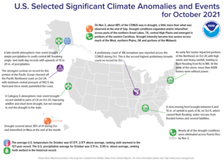
Conveyor belts of Pacific moisture, defined as atmospheric rivers, impacted much of the central West Coast from October 19-26. On October 24, a Category 5 (exceptional) atmospheric river event brought record rainfall to parts of central California. The heavy rain near wildfire burn scars triggered multiple landslides, yet helped partially snuff out the wildfire season and lessened the drought severity across this portion of the West.
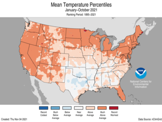
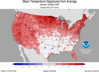
For October, the average contiguous U.S. temperature was 57.0°F, 2.9°F above the 20th-century average. This ranked sixth warmest in the 127-year period of record. For the year-to-date, the contiguous U.S. average temperature was also 57.0°F, 2.0°F above average, and ranked ninth warmest in the January-October record.
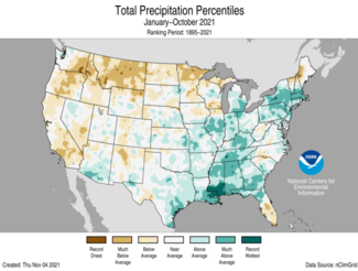
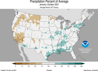
The October precipitation total for the contiguous U.S. was 3.11 inches, 0.95 inch above average, and ranked ninth wettest in the historical record. For the year-to-date, the contiguous U.S. precipitation total was 26.74 inches, 1.38 inches above average, and ranked in the wettest third of the January-October record.
This monthly summary from NOAA National Centers for Environmental Information is part of the suite of climate services NOAA provides to government, business, academia, and the public to support informed decision-making.
October
Temperature
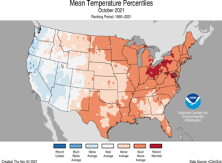
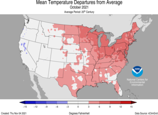
- Temperatures were above average from the Rocky Mountains to the East Coast. Ohio and Maryland ranked warmest on record for October while Pennsylvania, Delaware, New Jersey, Massachusetts, Rhode Island and Maine each ranked second warmest. Temperatures were below average across portions of the West Coast and Southwest.
- Alaska ranked in the middle third of the October record with a statewide average temperature of 28.0°F, 2.5°F above the long-term average. Temperatures were above average across portions of the Alaskan Interior and North Slope and slightly below average across the Panhandle. Despite the year-to-year downward trend in October sea ice extent, the average Chukchi Sea ice extent during October was the highest seen since 2001.
Precipitation
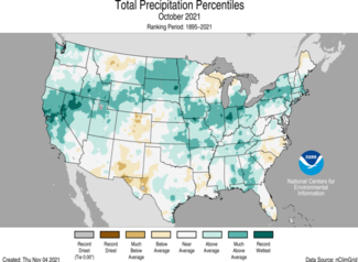
- Precipitation was above average across parts of the West, Plains, Great Lakes, Midwest, Southeast and Northeast. California and Illinois ranked fourth wettest on record for October. Precipitation was below average across portions of the Southwest, central Rockies and western Great Lakes.
- Multiple atmospheric river (AR) events occurred from October 19-26. The AR Category 5 event on October 24 brought record rainfall to portions of central California. Sacramento, Blue Canyon and Santa Rosa each reported their wettest 24-hour period on record during this event. Heavy mountain snowfall made travel through passes nearly impossible.
- While the AR events were impacting the West Coast, the East Coast experienced an early fall Nor’easter. On October 26, high winds and heavy rainfall led to flash flooding and power outages from New Jersey to Massachusetts.
- Alaska’s statewide average of 4.50 inches of precipitation in October was 0.11 inch above the long-term average and ranked in the middle one-third of the 97-year record. A late-month atmospheric river event transported ample amounts of moisture into south-central Alaska. Alyeska reported its wettest single day and 3-day period on record with 9.53 inches and 15.05 inches of precipitation, respectively. Portage Glacier Visitors Center received nearly 20 inches of rain during the last three days of October with accumulations continuing into early November.
- According to the November 2 U.S. Drought Monitor report, approximately 48 percent of the contiguous U.S. was in drought, a little more than what was observed at the end of September. Drought conditions expanded and/or intensified across parts of the northern Great Lakes, Texas, central High Plains and emerged in portions of the eastern Carolinas. Drought intensity became less severe across much of the West, northern Plains, Oklahoma, portions of the Midwest and was nearly eliminated across Puerto Rico.
Extremes
- A persistent ridge of high pressure across the eastern U.S. contributed to the record warm October temperatures observed in locations spanning from Milwaukee to New Haven, CT. Record-warm mild nights were observed from the Great Lakes to southern New England and were the main driver for these warm monthly temperatures.
- An all-time record low pressure system (942.5 mb) for a storm in this region developed in the eastern Pacific Ocean and strengthened rapidly on October 24, generating hurricane force winds and wave heights up to 45 feet off the coast of Washington and Oregon while channeling several waves of Pacific moisture toward the West Coast.
- Sacramento, CA, set a record of 211 days without measurable precipitation in 2021. This streak ended on October 17. On October 24, a category 5 atmospheric river event brought 5.45 inches of rainfall to Sacramento, breaking the previous single-day precipitation record of 5.28 inches, set in 1880.
- Preliminary tornado counts across the U.S. during October were second highest on record for the month with a count of 146. Only preliminary counts in 2018 ranked higher with 159 tornadoes reported. Oklahoma reported a record 31 tornadoes for October, which exceeds the previous record of 27 set in 1998.
Year-to-date (January-October)
Temperature
- Year-to-date temperatures were above average across much of the Lower 48. Maine ranked second warmest on record while Vermont and New Hampshire ranked third warmest on record for this 10-month period. Temperatures were below average across portions of the Deep South.
- Temperatures across Alaska ranked in the middle third of the historical record for January-October with a statewide average temperature of 30.6°F, 1.0°F above the long-term average. Temperatures were above average across portions of southwestern and northeastern Alaska.
Precipitation
- January-October precipitation was above average from the Deep South to the Great Lakes and into the Northeast. Mississippi and Massachusetts ranked third wettest while Louisiana ranked fourth wettest for this year-to-date period. Precipitation was below average across portions of the West, northern Plains, Great Lakes and New England. Montana ranked fourth driest for this period.
- Across Alaska, year-to-date precipitation was above average. Cook Inlet was drier than average while much of the Interior regions, West Coast, North Slope and Panhandle received above-average precipitation for the first 10 months of the year.
For more detailed climate information, check out our comprehensive October 2021 U.S. Climate report scheduled for release on November 12, 2021.

