
Extremes in both temperature and precipitation characterize October across the contiguous U.S.

For October, the average contiguous U.S. temperature was 52.3°F, 1.8°F below the 20th century average. This ranked in the lowest third of the 125-year period of record and was the coolest October since 2009. Below-average temperatures were observed from the High Plains to the Pacific Coast, while above-average temperatures blanketed the eastern third of the contiguous U.S. Parts of southern Florida were record warm. For the year-to-date, the contiguous U.S. average temperature was 55.5°F, 0.5°F above average, and ranked in the warmest third of the historical record.
The October precipitation total for the contiguous U.S. was 3.14 inches, 0.98 inch above average, and ranked as the eighth wettest October in the historical record. Above-average precipitation fell across much of the eastern half of the contiguous U.S., with record precipitation occurring across portions of the Great Lakes and the Mississippi Valley. Below-average precipitation fell across parts of the West, as well as the central and southern Plains. For the year-to-date, the contiguous U.S. precipitation total was 30.25 inches, 4.89 inches above average, and was the wettest January–October on record. Average precipitation across the contiguous U.S. for the 12-month period November 2018–October 2019 was 36.21 inches, 6.28 inches above average, exceeding the previous November–October record set in 1972–73 by nearly 1.5 inches.

This monthly summary from NOAA National Centers for Environmental Information is part of the suite of climate services NOAA provides to government, business, academia, and the public to support informed decision-making.
October Temperature

Above- to much-above-average temperatures dominated across the East Coast, southern Great Lakes, Ohio Valley, and southern Plains. Florida ranked second warmest during October, while Georgia and South Carolina ranked third warmest.
-
Record heat blanketed the Southeast and mid-Atlantic states the first week of October, shattering many all-time October heat records.
-
Below- to much-below-average October temperatures were observed across the Northwest, Intermountain West, Great Plains, and western Great Lakes. Idaho ranked coldest for the month, breaking the 1919 record by 0.8°F. The states of Washington, Utah, and Wyoming ranked second coldest during October.
-
Great Falls, MT, reported a low of 9°F on October 1 — the coldest temperature on record in Great Falls so early in the fall season.
-
An early-season snowstorm across the Rockies and Midwest was accompanied by bitter cold temperatures during the last week of October. All-time record low temperature records for October were set across the West with some temperatures dipping well below zero. Peter Sinks, UT, often one of the nation’s coldest locations, dropped to −46°F early on October 30, according to the Utah Climate Center. This temperature may be the coldest October temperature on record across the contiguous U.S.
-
-
Alaska ranked in the warmest third of the October record with a statewide average temperature of 30.8°F, 5.3°F above the long-term average. Parts of the North Slope experienced temperatures averaging at least 9°F warmer than the historical average, while much of the Panhandle experienced a mild October. It was the second warmest October for Utqiaġvik (Barrow).
October Precipitation

-
Above- to much-above-average precipitation was observed across much of the eastern half of the contiguous U.S. Mississippi ranked wettest during October, while 11 additional states ranked among their 10 wettest Octobers on record.
-
Below- to much-below-average precipitation occurred across the West, with Arizona and California ranking among their 10 driest Octobers on record.
-
An upper-level trough and an associated cold front brought the northern Rockies and Plains their first significant snowstorm of the season. From October 9–13, one to two feet of snow accumulated across portions of Montana and North Dakota, with several locations noting their snowiest start to the season. Great Falls, MT, reported 27 inches of snow while Bismark, ND, measured 17.1 inches for the season-to-date.
-
Another early-season snow storm impacted the central Rockies and parts of the Plains and Midwest. Denver reported 6.6 inches of snow on October 29 — the largest one-day October snowfall for Denver since 2011. Snow from this system also fell across portions of the central Plains and Great Lakes.
-
October was wet across much of Alaska with portions of the Northeast Interior, Southeast Interior, and West Coast divisions reporting record wet conditions for the month.
-
According to the October 29 U.S. Drought Monitor report, approximately 18 percent of the contiguous U.S. was in drought, down slightly from 19 percent at the beginning of October. Drought conditions became less severe across parts of the Southeast, Tennessee and Ohio valleys, Texas, the Alaska Panhandle, Hawaii, and Puerto Rico. Drought intensified across the Four Corners region of the Southwest.
Extremes
-
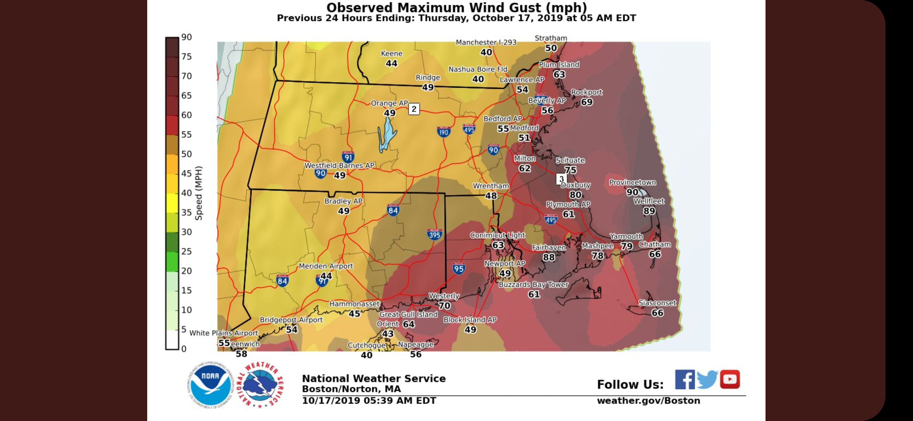
Subtropical Storm Melissa formed from a slow-moving East Coast nor’easter on October 11 with sustained winds of 65 mph. Impacts from Melissa included coastal flooding from Virginia to New York. Less than a week later, a mid-latitude cyclone, moving across the central and eastern United States, developed into a “Bomb Cyclone” (a storm whose central pressure drops by at least 24 millibars in 24 hours or less). This storm packed wind gusts up to 90 mph in southern New England on October 17 and left over 500,000 residents without power. New October low-pressure records were reported for various locations across Massachusetts, Rhode Island, and New Hampshire. Precipitation accumulations from this storm system measured between two and four inches across portions of New England.
-
Post-Tropical Cyclone Nestor made landfall on October 19 near Apalachicola, FL, with top sustained winds of 45 mph. The system brought between three and five inches of rainfall as well as tornadoes to the Florida Panhandle. Beneficial rains from the remnants of Nestor fell across parts of Georgia, South Carolina, North Carolina, and Virginia, which had been impacted by severe drought conditions.
-
Tropical Storm Olga merged with a cold front in the Gulf of Mexico on October 25 and made landfall as a post-tropical storm along the central Louisiana coast early the next morning. Many residents lost power across Louisiana as winds exceeded 70 mph, while tornadoes and wind damage impacted both Mississippi and Alabama.
-
Several large and dangerous wildfires impacted parts of north-central and southern California during October and remained active at the beginning of November. The Kincade Fire, located in north-central California, burned through nearly 78,000 acres and destroyed almost 350 structures by the end of October. The Tick, Saddleridge, and Getty fires in southern California consumed more than 14,000 acres as well as 60 structures. The Easy Fire, also located in southern California, consumed more than 1,700 acres by the end of October. These large and dangerous fires were fanned by powerful winds, with some gusts topping 100 mph in the Sierra Nevada range. Across southern California, unusually strong Santa Ana winds made it difficult for fire crews to keep these fires from spreading.
Year-to-date (January–October) Temperature

-
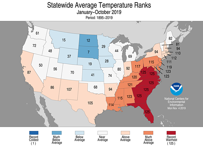
Above- to much-above-average year-to-date temperatures were observed from California to the southern Plains and from the Southeast to New England. Record warm temperatures were scattered throughout much of the Southeast and mid-Atlantic states. Thirteen states had a top 10 warm year-to-date period with Florida, Georgia, South Carolina, North Carolina, Virginia, and West Virginia reporting their warmest January–October on record.
-
Below-average temperatures occurred across the northern Plains and parts of the Midwest with South Dakota having its seventh coldest year-to-date period on record.
-
Alaska had its second warmest January–October on record. Record heat blanketed much of the North Slope and northern West Coast with portions of the Aleutians, the Northeast Interior, and Central interior also reporting record warm conditions. The rest of the state had above- to much-above-average temperatures for this 10-month period.
Year-to-date (January–October) Precipitation

-
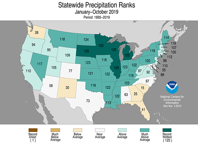
Above-average January–October precipitation dominated much of the country with record wet statewide ranks occurring in South Dakota, Minnesota, Wisconsin, Illinois, and Michigan. Below-average precipitation fell across the Pacific Northwest, parts of the Southwest and Southeast.


