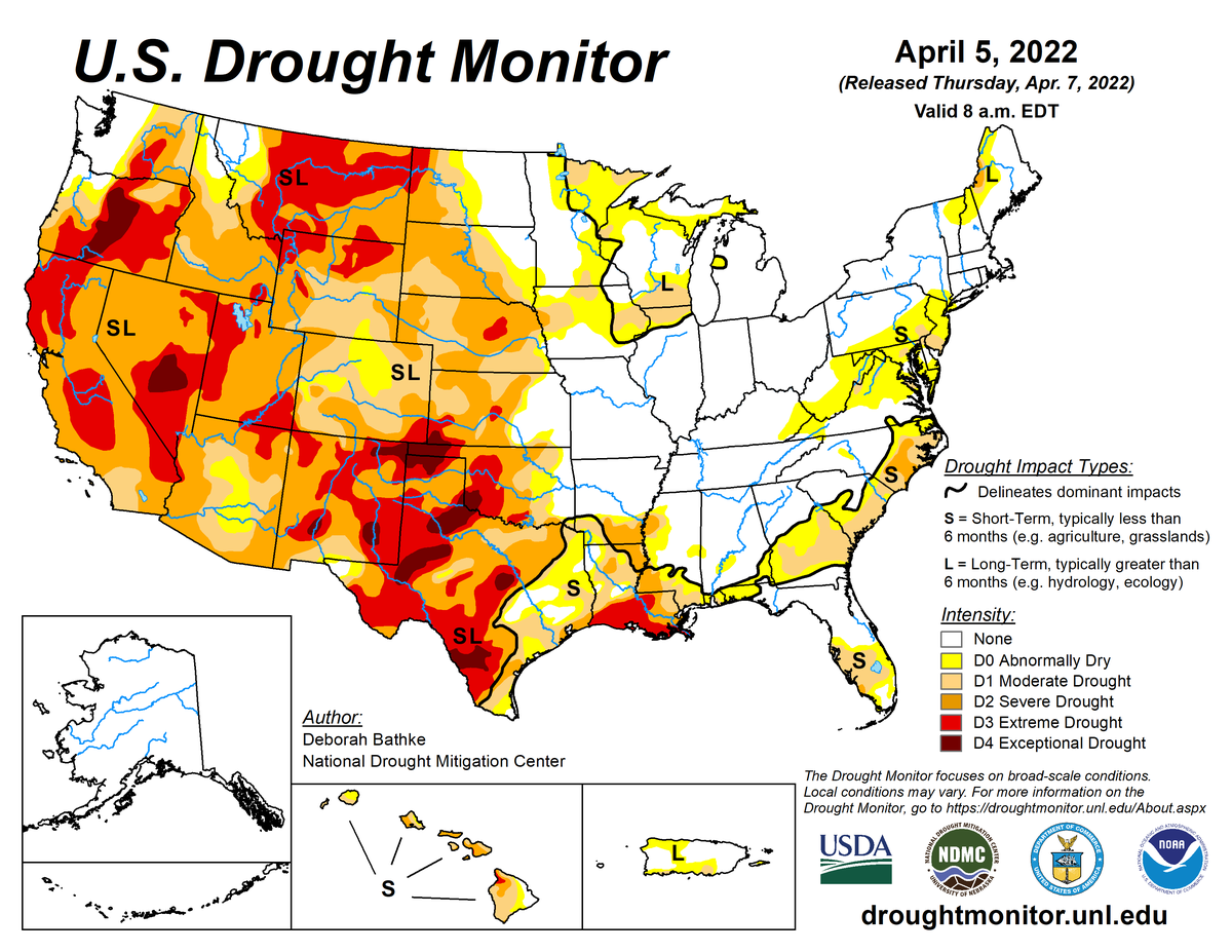
According to the April 5, 2022, U.S. Drought Monitor, moderate to exceptional drought covers 48.0% of the United States including Puerto Rico, a decrease from last week’s 48.6%. The worst drought categories (extreme to exceptional drought) increased slightly from 14.3% last week to 14.6%.
Four significant weather systems moved across the contiguous United States during the week of March 30–April 5. These systems began as upper-level disturbances accompanied by Pacific fronts and surface low pressure centers. They brought precipitation to parts of the Pacific Northwest and Rocky Mountains, but weekly totals were above normal in only a few places. A dominant upper-level long-wave ridge weakened the systems and kept most of the West drier than normal, with most of California and Nevada receiving no precipitation.
The weather systems were re-energized as they crossed into the Plains. They tapped moisture and energy from the Gulf of Mexico to spread precipitation across northeast Texas to the Great Lakes and into the Northeast, and rain mixed with severe weather across the South. However, many areas east of the Rockies missed out on the precipitation. These drier-than-normal areas included much of the Plains, Ohio Valley, and eastern Great Lakes, and coastal areas from Georgia to New Jersey.
With cold fronts alternating with warm fronts, temperatures were a mixed bag. The week ended up cooler than normal from the central Plains to Mid-Atlantic states and warmer than normal in California to the Great Basin and across the Gulf of Mexico coast. Drought or abnormal dryness contracted where the heaviest precipitation fell in parts of the southern Plains to Gulf Coast, and Upper Mississippi Valley to western Great Lakes.
Drought or abnormal dryness expanded or intensified across parts of the West, central and southern Great Plains, central Appalachians, and Mid-Atlantic coast where drier-than-normal conditions continued. Like the previous week, contraction exceeded expansion, with the nationwide moderate to exceptional drought area decreasing this week, but the area of most intense drought (extreme to exceptional drought) increased.

The full U.S. Drought Monitor weekly update is available from Drought.gov.
In addition to Drought.gov, you can find further information on the current drought as well as on this week’s Drought Monitor update at the National Drought Mitigation Center.
The most recent U.S. Drought Outlook is available from NOAA’s Climate Prediction Center and the U.S. Department of Agriculture provides information about the drought’s influence on crops and livestock.
For additional drought information, follow #DroughtMonitor on Facebook and Twitter.


