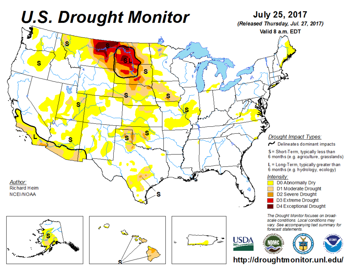
According to the July 25, 2017, U.S. Drought Monitor, moderate to exceptional drought covers 11.0% of the contiguous United States, an increase from last week’s 10.6%. The worst drought categories (extreme to exceptional drought) also increased from 2.3% last week to 2.6%, and they are now affecting over 350,000 people across the country.
An upper-level ridge of high pressure maintained its grip across the contiguous United States during this U.S. Drought Monitor week. The ridge kept temperatures warmer than normal from coast to coast, with the highest temperature departures from the High Plains to Mid-Atlantic States.
Weather systems moving in the jet stream flow rode over the top of the ridge, taking their surface lows and Pacific fronts along a northerly track into a trough over the eastern Lower 48 where they stalled out across the Midwest. Showers and thunderstorms developed as the fronts moved across the Northern Plains and into the Midwest, but rainfall amounts were mostly below normal.
Above-normal precipitation fell in places along the North Dakota–South Dakota border, from northeast South Dakota to northern Illinois, from the Ohio Valley to Mid-Atlantic States, and across parts of Nebraska and Kansas. Above-normal precipitation also fell across parts of the Southern Plains to Southeast as afternoon heating triggered convective storms, and a front near the end of the week sagged south.
The Southwest Monsoon continued this week, bringing above-normal precipitation to much of the Four Corners states and contracting drought and abnormal dryness. But drier-than-normal weather dominated the rest of the West, most of the Plains, much of the Midwest and South, and parts of the Mid-Atlantic and New England. Soils continued to dry out and crops suffered as drought and abnormal dryness continued to expand or intensify across the Plains, Midwest, northern Rockies, and Virginia.

The full U.S. Drought Monitor weekly update is available from Drought.gov.
In addition to Drought.gov, you can find further information on the current drought as well as on this week’s Drought Monitor update at the National Drought Mitigation Center.
The most recent U.S. Drought Outlook is available from NOAA’s Climate Prediction Center and the U.S. Department of Agriculture provides information about the drought’s influence on crops and livestock.
For additional drought information, follow #DroughtMonitor on Facebook and Twitter.


