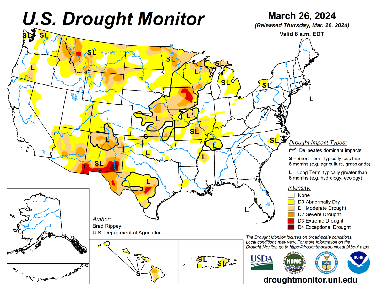
According to the March 26, 2024 U.S. Drought Monitor (USDM), moderate to exceptional drought covers 15.2% of the United States including Puerto Rico, a decrease from last week’s 17.8%. The worst drought categories (extreme to exceptional drought) decreased from 1.2% last week to 1.0%.
The atmospheric circulation at the upper levels over the contiguous U.S. underwent a change during this U.S. Drought Monitor week (March 20–26). The week started with a high-pressure ridge over the western contiguous U.S. and a low-pressure trough over the East, but ended with a trough over the western to central contiguous U.S. and ridge over the East Coast. This transition happened as a powerful upper-level Pacific weather system moved across the country. This upper-level system was manifested at the surface by strong low-pressure centers and cold fronts that brought rain and snow to several parts of the country. Weekly precipitation totals were above normal across much of the northern Plains to the Upper Midwest, all of New England, much of the East Coast, and parts of the southern Plains to the Lower Mississippi Valley.
The West had areas of above-normal precipitation mixed in with areas of below-normal precipitation. The week was drier than normal across the Rio Grande Valley, western parts of the High Plains to central Plains, the central Gulf of Mexico coast, all of the Ohio Valley, and much of the Tennessee Valley to the central Appalachians. The fronts brought colder temperatures that replaced the previously above-normal temperatures, so the week ended up colder than normal for most of the contiguous U.S. east of the Rockies and along the southern tier states. Only the Pacific Northwest and an area around the Mid-Mississippi Valley averaged near to warmer than normal for the week. Alaska was mostly warmer than normal for the week, with wetter-than-normal conditions across the west and drier-than-normal conditions for central to eastern Alaska. Hawaii and the U.S. Virgin Islands were mostly drier than normal, while it was a wetter-than-normal week for Puerto Rico.
Drought or abnormal dryness contracted or was reduced in intensity in parts of the Southwest, Puerto Rico, and the Plains to Mississippi Valley. Drought or abnormal dryness expanded or intensified in a few parts of the southern to central Plains, western High Plains, and Tennessee Valley. Nationally, contraction exceeded expansion, so the nationwide moderate to exceptional drought area decreased this week.
Nationally, contraction exceeded expansion, so the nationwide moderate to exceptional drought area decreased this week. Abnormal dryness and drought are currently affecting over 59 million people across the United States including Puerto Rico—about 19.2% of the population.

The full U.S. Drought Monitor weekly update is available from Drought.gov
In addition to Drought.gov, you can find further information on the current drought as well as on this week’s Drought Monitor update at the National Drought Mitigation Center
The most recent U.S. Drought Outlook is available from NOAA’s Climate Prediction Center and the U.S. Department of Agriculture provides information about the drought’s influence on crops and livestock
For additional drought information, follow #DroughtMonitor on Facebook and Twitter


