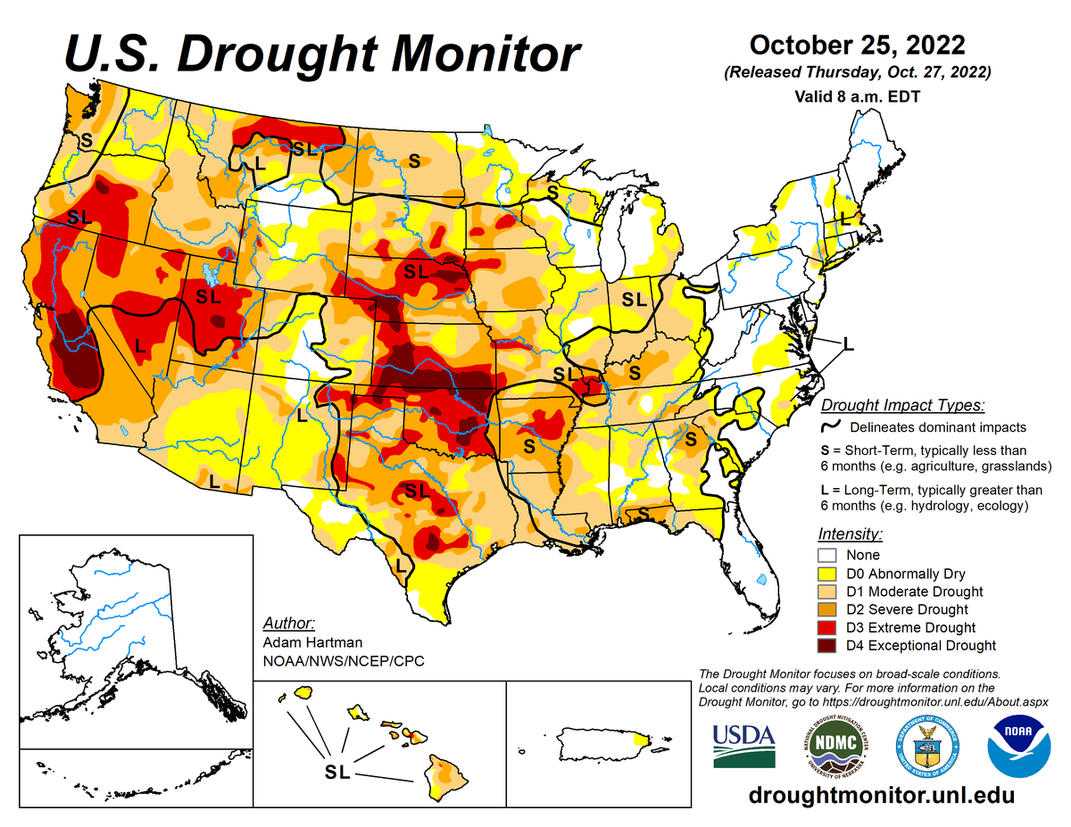
According to the October 25, 2022, U.S. Drought Monitor, moderate to exceptional drought covers 52.7% of the United States including Puerto Rico, an increase from last week’s 49.7%. The worst drought categories (extreme to exceptional drought) decreased slightly from 12.3% last week to 12.2%.
The upper-level circulation across the contiguous U.S. during this U.S. Drought Monitor (USDM) week (October 19-25) began with a strong ridge of high pressure over western North America and a deep trough over the eastern half of the continent, while an upper-level low pressure system was cut off from the jet stream flow and sat languishing over the Pacific just off the California coast. The circulation pattern shifted as the week wore on. A deep trough developed over the western contiguous U.S., weakening the ridge and pushing it eastward. The cutoff low was picked up in the jet stream flow and moved over the southern Plains states. Low pressure systems formed over the Atlantic Ocean just off the East Coast near the end of the week.
The week began with a large cold Canadian air mass over the eastern half of the contiguous U.S. and warmer-than-normal temperatures beneath the ridge over the West. But as the circulation pattern shifted, warmer-than-normal temperatures moved east and a Pacific front brought cooler-than-normal temperatures to the West. The Pacific front also spread rain and snow across much of the West, helping to extinguish many of the wildfires in the Pacific Northwest, and the front and upper-level low brought locally heavy rain to parts of the southern Plains to Mid-Mississippi Valley.
Fronts and the east coast lows also spread rain over parts of the Northeast. But large parts of the Southwest, central and southern Plains, and Lower and Upper Mississippi Valley, and much of the contiguous U.S. east of the Mississippi River, were drier than normal for the period, with soils continuing to dry out across most of the West, Plains, Midwest, and South. Drought and abnormal dryness contracted in parts of New Mexico to Missouri where the heaviest rains fell. But drought or abnormal dryness expanded in parts of the central Plains, and along much of the Mississippi River and areas eastward.
Nationally, expansion far exceeded contraction, with the nationwide moderate to exceptional drought area increasing again this week. About 52.7% of the U.S. (including Puerto Rico) was in moderate to exceptional drought as of October 25, 2022.
This is rapidly approaching the biggest drought extent in the USDM record of about 54.8% which occurred on September 25, 2012. Abnormal dryness and drought are currently affecting over 220 million people across the United States including Puerto Rico—about 70.8% of the population.

The full U.S. Drought Monitor weekly update is available from Drought.gov.
In addition to Drought.gov, you can find further information on the current drought as well as on this week’s Drought Monitor update at the National Drought Mitigation Center.
The most recent U.S. Drought Outlook is available from NOAA’s Climate Prediction Center and the U.S. Department of Agriculture provides information about the drought’s influence on crops and livestock.
For additional drought information, follow #DroughtMonitor on Facebook and Twitter.


