
NCEI is the central archive for the International Satellite Cloud Climatology Project (ISCCP), which began collecting data in July of 1983. Since then, the project has expanded to incorporate data from many different satellites. ISCCP receives data from a global network of Satellite Processing Centers (SPCs) that sample full resolution data to approximately 10km and 3 hourly resolution before sending it to NCEI for archive.
Access Methods
ISCCP-B1 data were remapped and calibrated as Gridded Satellite (GridSat) B1 data. We recommended using this data. If the GridSat B1 dataset does not meet your needs, contact NCEI for access to ISCCP-B1 data.
Citation
When possible, please cite Knapp (2008) when using the ISCCP-B1 data or other ISCCP-B1 imagery or GIBBS imagery in a publication or website.
Knapp, K. R., 2008: Scientific data stewardship of International Satellite Cloud Climatology Project B1 global geostationary observations. Journal of Applied Remote Sensing, 2, 023548, doi:10.1117/1.3043461.
ISCCP Cloud Products
The B1 data are used in a reprocessed ISCCP cloud product called ISCCP-H, which is available at a higher resolution (gridded products change from 2.5 degree to 1 degree spatial resolution). ISCCP-H is produced as a joint effort between NCEI and CICS-NC.
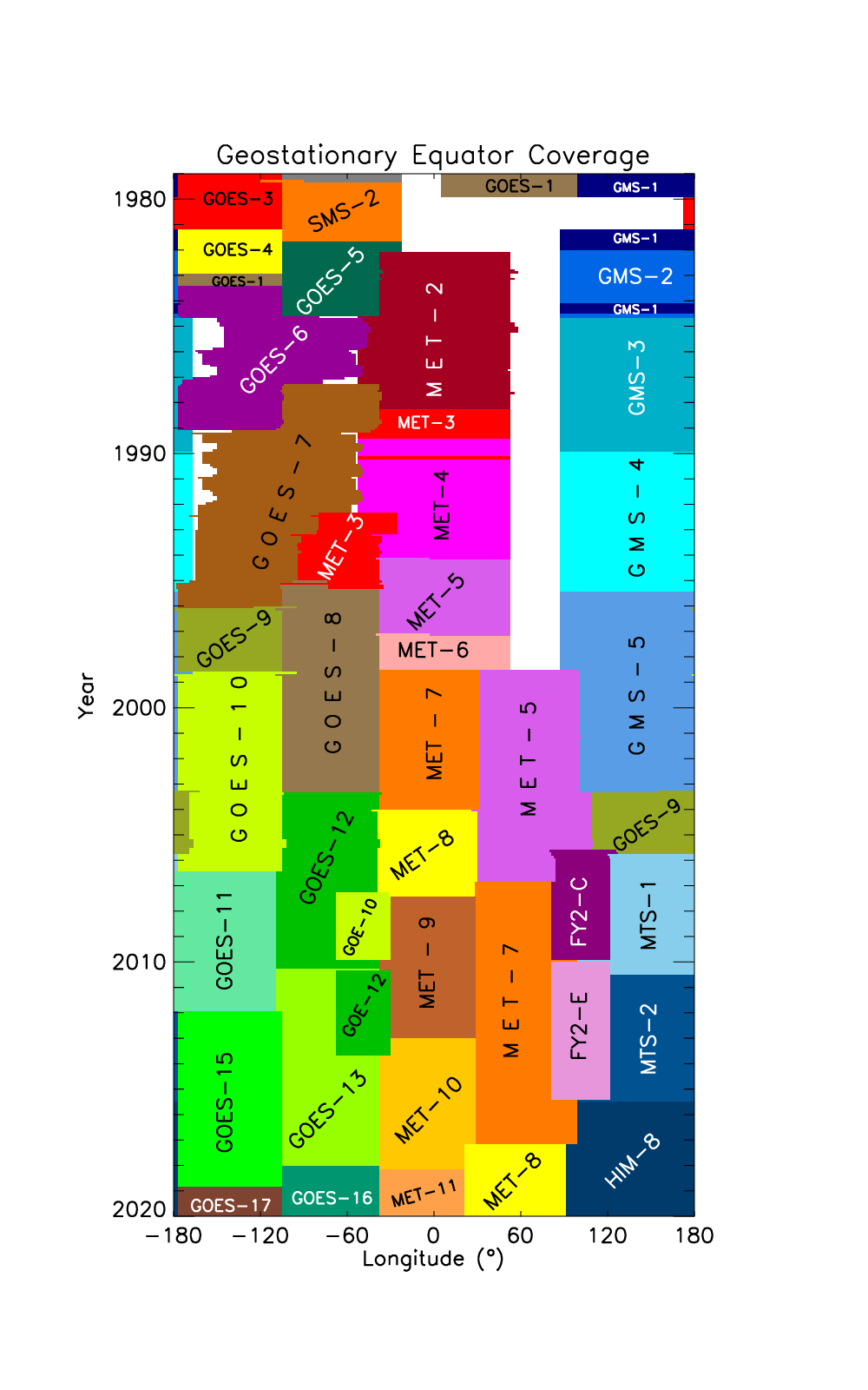
Information on geostationary satellites available for ISCCP processing.
| Satellite | Launch Date | Primary Location* |
Period of Record |
Bands Available |
|---|---|---|---|---|
| GOES-5 | 1981/05/22 | -75° | 1983/07/01-1984/07/30 | Visible & IR |
| GOES-6 | 1983/04/28 | -135° | 1983/09/30-1989/01/24 | Visible & IR |
| GOES-7 | 1987/02/26 | -100° | 1987/03/25-1996/01/17 | Visible & IR |
| GOES-8 | 1994/04/13 | -75° | 1994/11/30-2003/03/31 | All Imager Bands |
| GOES-9 | 1995/05/23 | -135° | 1996/01/01-1998/07/27 | All Imager bands |
| GOES-9¹ | 1995/05/23 | 155° | 2003/04/25-2005/10/01 | All Imager Bands |
| GOES-10 | 1997/04/25 | -135° | 1998/07/21-2006/06/21 | All Imager Bands |
| GOES-11 | 2000/05/03 | -135° | 2006/06/21-2011/12/06 | All Imager Bands |
| GOES-12 | 2001/07/23 | -75° | 2003/04/01-2010/04/14 | All Imager Bands |
| GOES-13 | 2006/05/24 | -75° | 2010/04/14-2018/01/08 | All Imager Bands |
| GOES-15 | 2010/03/04 | -135° | 2011/12/06-2020/03/02 | All Imager Bands |
| GOES-16 | 2016/11/19 | -75° | 2018/01/01-current | All ABI Bands |
| GOES-17 | 2018/03/1 | -135° | 2018/12/04-current | All ABI Bands |
| MET-2 | 1981/06/19 | 0° | 1983/08/31-2020/03/02 | Visible, WV & IR |
| MET-3 | 1988/06/15 | 0° | 1988/08/24-1989/06/19 | Visible, WV & IR |
| MET-3² | 1988/06/15 | -70° | 1992/09/11-1995/01/29 | Visible, WV & IR |
| MET-4 | 1989/03/06 | 0° | 1989/06/19-1994/02/04 | Visible, WV & IR |
| MET-5 | 1994/04/13 | 0° | 1994/01/01-1997/02/01 | Visible, WV & IR |
| MET-5³ | 1994/04/13 | 63° | 1998/06/01-2007/04/16 | Visible, WV & IR |
| MET-6 | 1993/11/20 | 0° | 1997/02/13-2000/01/20 | Visible, WV & IR |
| MET-7 | 1997/09/02 | 0° | 1998/05/31-2017/04/04 | Visible, WV & IR |
| MET-7³ | 1997/09/02 | 63° | 2007/04/16-current | Visible, WV & IR |
| MET-8 | 2002/07/28 | 0° | 2005/01/01-2007/05/10 | All MSG Bands |
| MET-8⁴ | 2002/07/28 | 41.5° | 2017/02/10-current | All MSG Bands |
| MET-9 | 2005/12/21 | 0° | 2007/05/10-2013/01/20 | All MSG Bands |
| MET-10 | 2012/07/05 | 0° | 2013/01/20-2018/02/20 | All MSG Bands |
| MET-11 | 2015/07/15 | 0° | 2018/02/20-current | All MSG Bands |
| GMS-1 | 1977/07/14 | 140° | 1984/01/21-1984/06/29 | Visible & IR |
| GMS-2 | 1981/08/11 | 140° | 1983/06/30-1984/09/26 | Visible & IR |
| GMS-3 | 1984/08/03 | 140° | 1984/09/27-1989/12/03 | Visible & IR |
| GMS-4 | 1989/09/06 | 140° | 1989/12/04-1995/06/12 | Visible & IR |
| GMS-5 | 1995/03/18 | 140° | 1995/06/13-2003/05/21 | Visible, WV & IR |
| MTS-1 | 2005/02/26 | 140° | 2005/10/01-2010/06/30 | Visible, WV & IR |
| MTS-2 | 2006/02/18 | 140° | 2010/06/30-2015/07/06 | Visible, WV & IR |
| HIM-8 | 2014/10/07 | 141° | 2015/07/07-present | All AHI Bands |
Global ISCCP B1 Browse System (GIBBS)
GIBBS provides access to global geostationary satellite data from nearly every location on Earth at three hourly intervals from 1980–present. More than one million images are available.
Citation
When possible, please cite Knapp (2008) when using the GIBBS imagery, the "GEO-Quilt" or other ISCCP-B1 imagery in a publication or website.
Knapp, K. R., 2008: Scientific data stewardship of International Satellite Cloud Climatology Project B1 global geostationary observations. Journal of Applied Remote Sensing, 2, 023548, non-government domain. doi:10.1117/1.3043461
Infrared Image Color Scales
Infrared imagery is displayed on a color scale that correlates with temperatures observed by the satellite. NCEI provides access to high resolution versions for publication (e.g., encapsulated postscript (EPS) for a published report or paper).
Infrared Window Color Scale
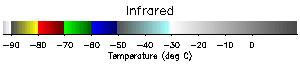
Infrared Water Vapor Color Scale
Contact Information
Contact customer service with any questions about the ISCCP-B1 data or GIBBS imagery.
Email: NCDC.SatOrder@noaa.gov
Project History
Data Rescue
The ISCCP B1 data figuratively sat on a shelf at NCEI until data rescue efforts began in 2003. By then, data were for most part unusable because of unknown or outdated storage formats and non-existent read/write routines. Over many years, NCEI developed new read and navigation algorithms for all B1 data. Along the way, gaps in the inventory were discovered and subsequently filled by SPCs and NCEI. The B1 data rescue was successful and has resulted in the use of ISCCP B1 data in numerous scientific endeavors.
Data Backfilling
NCEI has recreated B1 data for dates before the start of ISCCP data collection (July 1, 1983). This involved retrieving data from the NOAA Comprehensive Large Array-Data Stewardship System (CLASS), subsampling the full resolution data to the B1 level, then checking the quality using B1 processing algorithms. EUMETSAT (Europe) and JMA (Japan) kindly performed similar steps providing early B1 data for Meteosat-2 and GMS-1. The result of the backfilling extended the beginning of ISCCP B1 coverage from July 1983 to as early as 1978 for some satellites.
Peer Reviewed
- Knapp, K. R., 2008: Calibration of long-term geostationary infrared observations using HIRS. Journal of Atmospheric and Oceanic Technology, 5 (2), 183-195. doi:10.1175/2007JTECHA910.1.
- Knapp, K. R., J. J. Bates and B. Barkstrom, 2007: Scientific Data Stewardship: Lessons from a satellite data rescue effort. Bulletin of the AMS, 88 (9), 1359-1361. doi:10.1175/BAMS-88-9-1359.
ISCCP B1 Related work
- Knapp, K. R. and J. P. Kossin, 2007: New global tropical cyclone data from ISCCP B1 geostationary satellite observations. Journal of Applied Remote Sensing. 1, 013505. doi:10.1117/1.2712816 | PDF
- Kossin, J. P., D. J. Vimont, K. R. Knapp, and R. J. Murnane, 2006:
A Reanalysis of Global Hurricane Trends. Geophy. Res. Lett., 34, L04815. doi:10.1029/2006GL028836


