
The Coastal and Marine Ecological Classification Standard (CMECS) is a catalog of terms and definitions used to describe and classify marine ecological data using a simple, standard format and common terminology. CMECS allows users to organize and interpret marine observational data using a collection of settings (aquatic and biogeographic) and components (biotic, water column, substrate, and geoform) in a semi-hierarchical framework.
More information about CMECS, including technical guidance and examples of how to apply the standard, is available at the NOAA Integrated Ocean and Coastal Mapping Coordination Team’s website.

About
Individual projects implement CMECS in different ways to meet specific mapping and research needs, resulting in various approaches to utilizing the framework.
The CMECS in Action interactive map shows the locations of a growing collection of projects across U.S estuarine, marine, and Great Lakes waters. The map includes information about the project, the settings and components used, and links to project resources and data where available.
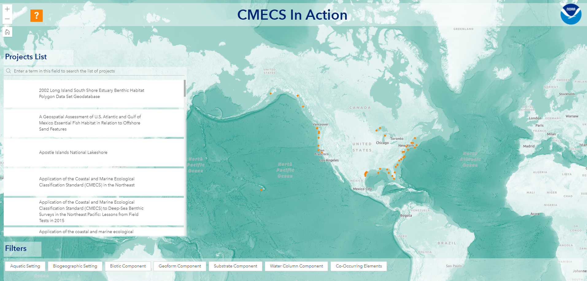
All the information displayed in the application is also available in this accessible, 508-compliant table.
Email ocm.cmecs-ig@noaa.gov with your project information so we can share it with others.
Federal Geographic Data Committee (FGDC)
CMECS, which was endorsed by the Federal Geographic Data Committee (FGDC) in 2012, builds on previous approaches from published national, regional, and local habitat classification procedures, and it provides a framework and process for future iterations of marine ecological classification (see Vocabulary Maintenance). The FGDC recommends federally funded projects use their endorsed standards in all federally-funded work.
The Coastal and Marine Ecological Classification Standard
This Federal Geographic Data Committee (FGDC) document describes the CMECS vocabulary and framework, and presents implementation guidance and examples.
Additional Information
CMECS Catalog of Units Database
This database contains the CMECS Catalog of Units.
Coding System Approach for CMECS Classification and Modifier Units
A user guide for the CMECS Codeset that includes an explanation of the codeset structure, examples, and other useful documentation.
CMECS Codeset
This workbook contains the CMECS Units and Codeset, organized in the CMECS component and settings framework.
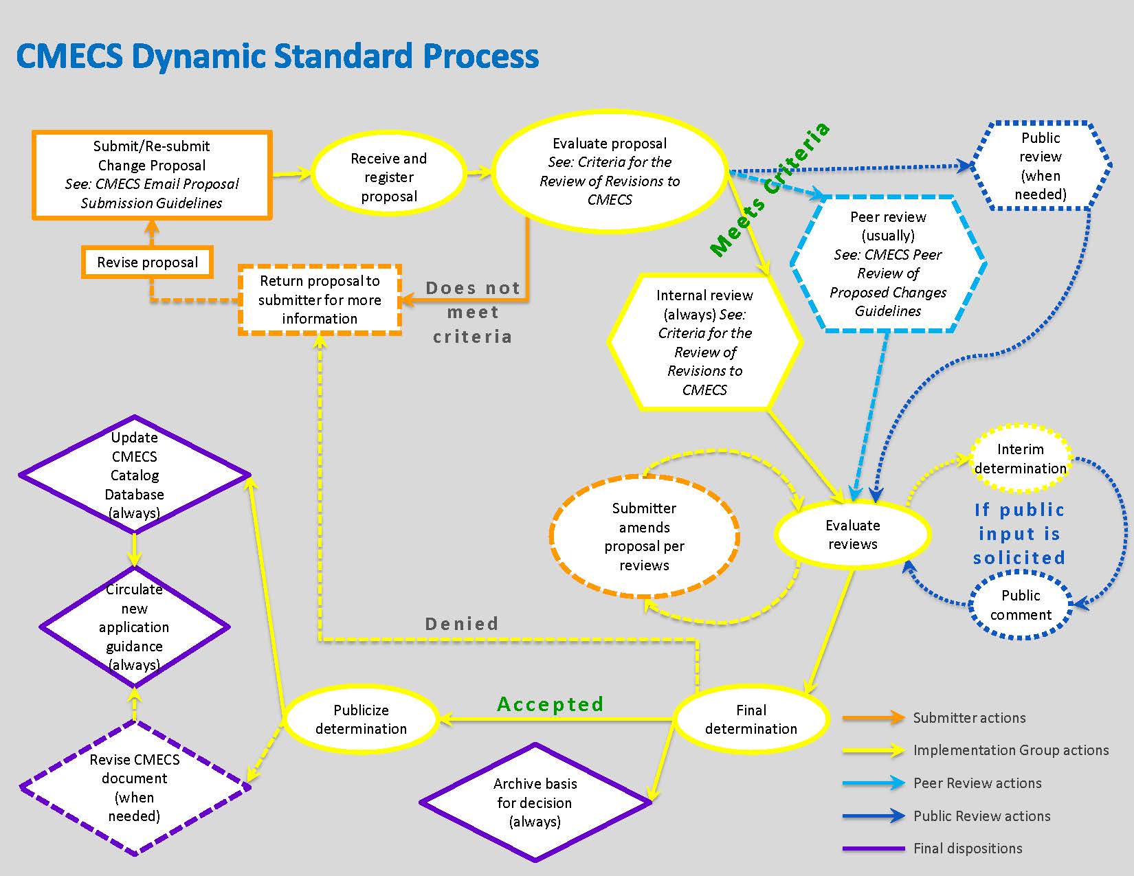
Dynamic Standard Process (DSP)
CMECS was designed as a Dynamic Content Standard, allowing it to be updated periodically to reflect advances in scientific knowledge, technology, and the needs of coastal management communities. The CMECS Implementation Group developed the Dynamic Content Process (DSP) (see figure) to collect and evaluate change proposals and suggested revisions from the user community.
Questions about the CMECS update and the DSP can be sent to ocm.cmecs-update@noaa.gov
Who can propose changes to CMECS?
Anyone can propose changes to CMECS. Most change proposals will likely come from people who have used CMECS in their work and have identified ways that the structure or vocabularies would work better for them.
For example, practitioners may have used provisional units* to supplement the CMECS vocabulary, or they may have found that the defined ranges of a parameter aren't descriptive enough of their data. Change proposals can also address minor edits, such as grammatical or typographical corrections and clarifications of definitions and meanings.
* Provisional units are proposed new units that nest fully within the existing CMECS hierarchy and may be used where 1) there is no existing CMECS unit or 2) the provisional unit better describes the existing CMECS unit. Provisional units are most likely to occur in the Geoform component as new geoforms or in the Biotic component as new biotic communities.
Proposing CMECS Revisions
Requests for formal changes or addition of new units should be submitted through the Proposed Change Request Form. The DSP proposal review workflow followed by the CMECS IG is outlined in Figure 1.
Please read the following guidance documents before submitting a change proposal:
- CMECS Proposal Submission Guidelines
- Criteria for the Review of Revisions to CMECS
- CMECS Peer-Review Guidelines
Change Proposal Summaries and Status
The Proposal Tracking Table shows summaries of the change proposals that have been submitted, including the review status and a link to the final disposition and justification. The table will be updated as new information becomes available. If you have questions or comments about any of these proposals, please email us at ocm.cmecs-update@noaa.gov.


