Quality-Controlled Underway Oceanographic and Meteorological Data from the Center for Ocean-Atmospheric Predictions Studies (COAPS) - Shipboard Automated Meteorological and Oceanographic System (SAMOS)
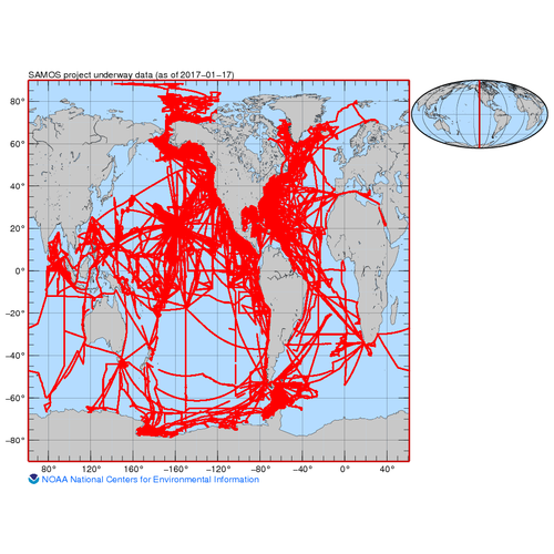 Preview graphic
The Florida State University Center for Ocean-Atmospheric Predictions Studies (COAPS) has been operating a data assembly center (DAC) to collect, quality evaluate, and distribute Shipboard Automated Meteorological and Oceanographic System (SAMOS) observations since 2005. A SAMOS is typically a computerized data logging system that records underway meteorological and near-surface oceanographic observations collected on research vessels. The SAMOS initiative does not provide specific instrumentation for vessels, but instead takes advantage of science quality instrumentation already deployed on research vessels and select merchant ships. The SAMOS initiative provides vessel operators with desired sampling protocols and metadata requirements that will ensure the DAC receives a consistent series of observations from each vessel. The DAC and its partners in U. S. National Oceanic and Atmospheric Administration (NOAA), the University National Oceanographic Laboratory System, the U. S. Coast Guard, and the U. S. Antarctic Program have implemented a series of daily data transmissions from ship-to-shore using an email protocol. A set of observations recorded at one-minute intervals for the previous day arrive at the DAC soon after 0000 UTC and undergo automated quality evaluation. A trained data analyst reviews data and responds directly to vessels at sea when problems are identified. A secondary level of visual quality control is completed after all data from a single ship and day are merged into a common daily file (allowing for delayed data receipts). All quality-evaluated data are freely available to the user community and are distributed to national archive centers. This dataset contains all of these data.
- Cite as: Smith, Shawn R.; Rolph, Jeremy J.; Briggs, Kristen; Bourassa, Mark A. (2009). Quality-Controlled Underway Oceanographic and Meteorological Data from the Center for Ocean-Atmospheric Predictions Studies (COAPS) - Shipboard Automated Meteorological and Oceanographic System (SAMOS). [indicate subset used]. NOAA National Centers for Environmental Information. Dataset. https://doi.org/10.7289/v5qj7f8r. Accessed [date].
gov.noaa.nodc:COAPS-SAMOS
| Search Data |
-
Granule Search (search)
Search for data granules belonging to this collection (a granule is the smallest aggregation of data that can be independently described and retrieved).
|
| Download Data |
-
THREDDS (download)
These data are available through a variety of services via a THREDDS (Thematic Real-time Environmental Distributed Data Services) Data Server (TDS). Depending on the dataset, the TDS can provide WMS, WCS, DAP, HTTP, and other data access and metadata services as well. For more information on the TDS, see http://www.unidata.ucar.edu/software/thredds/current/tds/.
-
HTTPS (download)
Navigate directly to the URL for data access and direct download.
-
FTP (download)
These data are available through the File Transfer Protocol (FTP). FTP is no longer supported by most internet browsers. You may copy and paste the FTP link to the data into an FTP client (e.g., FileZilla or WinSCP).
|
| Distribution Formats |
- netCDF (Version: netCDF-3)
- File Specification: SAMOS netCDF Version 1.0
- CSV
- ASCII
|
| Ordering Instructions |
Contact NCEI for other distribution options and instructions. |
| Distributor |
NOAA National Centers for Environmental Information
+1-301-713-3277
ncei.info@noaa.gov
|
| Dataset Point of Contact |
NOAA National Centers for Environmental Information
ncei.info@noaa.gov
|
| Time Period |
2005-05-09 to Present |
| Spatial Bounding Box Coordinates |
West: -180
East: 180
South: -79
North: 90
|
| Spatial Coverage Map |
|
| General Documentation |
|
| Associated Resources |
- Shipboard Automated Meteorological and Oceanographic System (SAMOS)
- Smith, SR, Briggs, K, Bourassa, MA, Elya, J, Paver, CR. Shipboard automated meteorological and oceanographic system data archive: 2005–2017. Geosci Data J. 2018; 5: 73– 86. https://doi.org/10.1002/gdj3.59
|
| Publication Dates |
- publication: 2009-09-09
- revision: 2025-12-17
- creation: 2008-08-20
|
| Data Presentation Form |
Digital table - digital representation of facts or figures systematically displayed, especially in columns
|
| Dataset Progress Status |
Ongoing - data is continually being updated
Historical archive - data has been stored in an offline storage facility |
| Data Update Frequency |
Monthly |
| Purpose |
Provide quality underway meteorological and physical oceanographic data to the user community. |
| Use Limitations |
- Distribution liability: NOAA and NCEI make no warranty, expressed or implied, regarding these data, nor does the fact of distribution constitute such a warranty. NOAA and NCEI cannot assume liability for any damages caused by any errors or omissions in these data. If appropriate, NCEI can only certify that the data it distributes are an authentic copy of the records that were accepted for inclusion in the NCEI archives.
|
| Dataset Citation |
- Cite as: Smith, Shawn R.; Rolph, Jeremy J.; Briggs, Kristen; Bourassa, Mark A. (2009). Quality-Controlled Underway Oceanographic and Meteorological Data from the Center for Ocean-Atmospheric Predictions Studies (COAPS) - Shipboard Automated Meteorological and Oceanographic System (SAMOS). [indicate subset used]. NOAA National Centers for Environmental Information. Dataset. https://doi.org/10.7289/v5qj7f8r. Accessed [date].
|
| Cited Authors |
|
| Contributors |
|
| Resource Providers |
|
| Points of Contact |
|
| Publishers |
|
| Acknowledgments |
- This project is supported by the NOAA Climate Observation Division.
|
| Theme keywords |
NODC DATA TYPES THESAURUS
NODC OBSERVATION TYPES THESAURUS
WMO_CategoryCode
Global Change Master Directory (GCMD) Science Keywords
SAMOS Data Types
- air temperature
- air temperature 2
- air temperature 3
- air temperature 4
- atmospheric pressure
- atmospheric pressure 2
- atmospheric pressure 3
- atmospheric pressure 4
- conductivity
- conductivity 2
- dew point temperature
- dew point temperature 2
- earth relative wind direction
- earth relative wind direction 2
- earth relative wind direction 3
- earth relative wind direction 4
- earth relative wind speed
- earth relative wind speed 2
- earth relative wind speed 3
- earth relative wind speed 4
- latitude
- long wave atmospheric radiation
- long wave atmospheric radiation 2
- longitude
- net atmospheric radiation
- net atmospheric radiation 2
- photosynthetically active atmospheric radiation
- photosynthetically active radiation 2
- platform course
- platform course 2
- platform course 3
- platform course 4
- platform heading
- platform heading 2
- platform heading 3
- platform relative wind direction
- platform relative wind direction 2
- platform relative wind direction 3
- platform relative wind direction 4
- platform relative wind speed
- platform relative wind speed 2
- platform relative wind speed 3
- platform relative wind speed 4
- platform speed over ground
- platform speed over ground 2
- platform speed over ground 3
- platform speed over ground 4
- platform speed over water
- platform speed over water 2
- platform speed over water 3
- precipitation accumulation
- precipitation accumulation 2
- precipitation accumulation 3
- rain rate
- rain rate 2
- rain rate 3
- relative humidity
- relative humidity 2
- relative humidity 3
- salinity
- salinity 2
- sea temperature
- sea temperature 2
- sea temperature 3
- sea temperature 4
- sea temperature 5
- sea temperature 6
- short wave atmospheric radiation
- shortwave atmospheric radiation 2
- time
- wet bulb temperature
|
| Data Center keywords |
NODC COLLECTING INSTITUTION NAMES THESAURUS
NODC SUBMITTING INSTITUTION NAMES THESAURUS
Global Change Master Directory (GCMD) Data Center Keywords
|
| Platform keywords |
NODC PLATFORM NAMES THESAURUS
Global Change Master Directory (GCMD) Platform Keywords
ICES/SeaDataNet Ship Codes
- ATLANTIS (call sign: KAQP, ICES code: 33AT, 1997-)
- Atlantic Explorer (call sign: WDC9417, ICES code: 33H4, 2005-)
- Bell M. Shimada (call sign: WTED, ICES code: 3322, 2010-)
- DAVID STARR JORDAN (call sign: WTDK, ICES code: 31JD, 1966-2010)
- DELAWARE II (ICES code: 316G)
- FAIRWEATHER (call sign: WTEB, ICES code: 317W)
- FALKOR (TOO) (call sign: ZGOJ7, ICES code: CIRF, 2022-)
- FERDINAND R. HASSLER (call sign: WTEK, ICES code: 33FI, 2012-)
- Falkor (call sign: ZCYL5, ICES code: CIFR, 2009-2022)
- GORDON GUNTER (call sign: WTEO, ICES code: 33GG, 1998-)
- HEALY (call sign: NEPP, ICES code: 33HQ, 1999-)
- HENRY B. BIGELOW (call sign: WTDF, ICES code: 33HH, 2005-)
- Hi'ialakai (call sign: WTEY, ICES code: 33HL, 2004-)
- KA'IMIMOANA (call sign: WTEU, ICES code: 33KM, 1996-2014)
- KNORR (call sign: KCEJ, ICES code: 316N, 1970-)
- Kilo Moana (call sign: WDA7827, ICES code: 33KB, 2002-)
- LAURENCE M. GOULD (call sign: WCX7445, ICES code: 33LG, 1998-)
- MELVILLE (call sign: WECB, ICES code: 318M, 1969-)
- MILLER FREEMAN (call sign: WTDM, ICES code: 31FN, 1974-)
- McArthur II (call sign: WTEJ, ICES code: 33MH, 2003-2014)
- NANCY FOSTER (call sign: WTER, ICES code: 33NF, 2004-)
- NATHANIEL B. PALMER (call sign: WPB3210, ICES code: 3206, 1992-)
- NEIL ARMSTRONG (call sign: WARL, ICES code: 33VB, 2015-)
- NEW HORIZON (call sign: WKWB, ICES code: 32NM, 1978-2015)
- OCEANUS (call sign: WXAQ, ICES code: 32OC, 1976-)
- OKEANOS EXPLORER (call sign: WTDH, ICES code: 334A, 2008-)
- OREGON II (call sign: WTDO, ICES code: 316O, 1977-)
- OSCAR DYSON (call sign: WTEP, ICES code: 33OA, 2005-)
- OSCAR ELTON SETTE (call sign: WTEE, ICES code: 33OC, 2003-)
- PELICAN (call sign: WSK3051, ICES code: 32PE, 1985-)
- PISCES (call sign: WTDL, ICES code: 334B, 2009-)
- POLAR SEA (call sign: NRUO, ICES code: 32L9, 1977-)
- RAINIER (call sign: WTEF, ICES code: 315R, 1968-)
- REUBEN LASKER (call sign: WTEG, ICES code: 33UD, 2014-)
- ROBERT GORDON SPROUL (call sign: WSQ2674, ICES code: 32QU, 1981-)
- ROGER REVELLE (call sign: KAOU, ICES code: 33RR, 1996-)
- Ronald H. Brown (call sign: WTEC, ICES code: 33RO, 1997-)
- SALLY RIDE (call sign: WSAF, ICES code: 33P4, 2016-)
- SOUTHERN SURVEYOR (call sign: VLHJ, ICES code: 09SS, 1988-2014)
- Sikuliaq (call sign: WDN7246, ICES code: 33BI, 2013-)
- THOMAS G. THOMPSON (call sign: KTDQ, ICES code: 3250, 1991-)
- THOMAS JEFFERSON (call sign: WTEA, ICES code: 33TJ, 2003-)
|
| Instrument keywords |
NODC INSTRUMENT TYPES THESAURUS
Global Change Master Directory (GCMD) Instrument Keywords
|
| Place keywords |
NODC SEA AREA NAMES THESAURUS
Geographic Names Information System (GNIS)
- Buzzards Bay
- Mare Island California Naval Shipyard
- Mare Island Strait
- Napa River
- Woods Hole
Global Change Master Directory (GCMD) Location Keywords
Integrated Marine Information System (IMIS)
|
| Project keywords |
NODC PROJECT NAMES THESAURUS
Global Change Master Directory (GCMD) Project Keywords
|
| Keywords |
NCEI ACCESSION NUMBER
|
| Use Constraints |
- Cite as: Smith, Shawn R.; Rolph, Jeremy J.; Briggs, Kristen; Bourassa, Mark A. (2009). Quality-Controlled Underway Oceanographic and Meteorological Data from the Center for Ocean-Atmospheric Predictions Studies (COAPS) - Shipboard Automated Meteorological and Oceanographic System (SAMOS). [indicate subset used]. NOAA National Centers for Environmental Information. Dataset. https://doi.org/10.7289/v5qj7f8r. Accessed [date].
|
| Access Constraints |
- Use liability: NOAA and NCEI cannot provide any warranty as to the accuracy, reliability, or completeness of furnished data. Users assume responsibility to determine the usability of these data. The user is responsible for the results of any application of this data for other than its intended purpose.
|
| Fees |
- In most cases, electronic downloads of the data are free. However, fees may apply for custom orders, data certifications, copies of analog materials, and data distribution on physical media.
|
| Lineage information for: repository |
|---|
| Processing Steps |
- 2015-04-22T00:00:00 - NOAA created the National Centers for Environmental Information (NCEI) by merging NOAA's National Climatic Data Center (NCDC), National Geophysical Data Center (NGDC), and National Oceanographic Data Center (NODC), including the National Coastal Data Development Center (NCDDC), per the Consolidated and Further Continuing Appropriations Act, 2015, Public Law 113-235. NCEI launched publicly on April 22, 2015.
|
| Acquisition Information (collection) |
|---|
| Instrument |
- accelerometer
- compass
- CTD
- echo sounder
- fluorometer
- GPS
- gyrocompass
- meteorological sensor
- oxygen sensor
- PAR Sensor
- pyrgeometer
- radiometer
- sound velocimeter
- sound velocimeter - moving vessel profiler
- temperature sensor
- thermometer
- thermosalinograph
- transmissometer
|
| Platform |
- Falkor (too)
- NEW HORIZON
- NOAA Ship Bell M. Shimada
- NOAA Ship David Starr Jordan
- NOAA Ship Delaware II
- NOAA Ship Fairweather
- NOAA Ship Ferdinand R. Hassler
- NOAA Ship Gordon Gunter
- NOAA Ship Henry B. Bigelow
- NOAA Ship Hi'ialakai
- NOAA Ship Ka'imimoana
- NOAA Ship McArthur II
- NOAA Ship Miller Freeman
- NOAA Ship Nancy Foster
- NOAA Ship Okeanos Explorer
- NOAA Ship Oregon II
- NOAA Ship Oscar Dyson
- NOAA Ship Oscar Elton Sette
- NOAA Ship Pisces
- NOAA Ship Rainier
- NOAA Ship Reuben Lasker
- NOAA Ship Ronald H. Brown
- NOAA Ship Thomas Jefferson
- OCEANUS
- R/V Atlantis
- R/V Falkor
- R/V KILO MOANA
- R/V Knorr
- R/V Laurence M. Gould
- R/V Melville
- R/V Pelican
- R/V Roger Revelle
- R/V Sally Ride
- R/V THOMAS G. THOMPSON
- ROBERT GORDON SPROUL
- RV Atlantic Explorer
- RV Nathaniel B. Palmer
- RV Neil Armstrong
- Sikuliaq
- SOUTHERN SURVEYOR
- USCGC Healy
- USCGC Polar Sea
|
Last Modified: 2025-12-31T02:21:33Z
For questions about the information on this page, please email:
ncei.info@noaa.gov