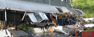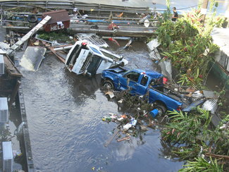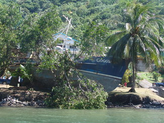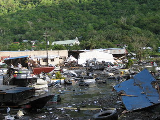
On an idyllic Monday night in 2009, the palm-lined coasts of the American Samoa, Samoa, and Tonga Islands looked peaceful and serene. But by early Tuesday morning, residents and tourists were struck a devastating blow when two massive earthquakes hit almost simultaneously 120 miles off the coast of the islands, triggering a tsunami that killed hundreds.
A Tsunami of Deadly Proportions
On September 29, 2009, two large earthquakes struck midway between Samoa and American Samoa, a U.S. territory. The earthquakes generated tsunami waves of up to 22 meters (72 feet) that engulfed the shores, killing at least 192 people—149 in Samoa, 34 in American Samoa, and 9 in Niuatoputapu, Tonga.
The devastation extended beyond human casualties with houses destroyed, cars swept out to sea and some villages being virtually annihilated. With over $200 million dollars in damages, the islands were ravaged both physically and economically.
An Uncommon Event
Most large earthquakes occur in subduction zones, where one plate of Earth’s crust dives beneath another plate. In this region, the Pacific plate subducts westward beneath the Australia plate at the Tonga Trench.
The deadly 2009 tsunami was triggered by at least two separate earthquakes occurring within 2–3 minutes of each other near the Tonga Trench, one of the most seismically active areas in the world. This is an extremely rare event, known as a “doublet.”
Since the earthquakes occurred so close in time, scientists have not been able to distinguish which earthquake occurred first or which caused a bigger tsunami. However, the events of September 29 involved a magnitude 8.1 earthquake on a normal fault within the outer rise; and the other magnitude 8.0 earthquake occurred on the subduction zone as a thrust event.
From Peril To Preparedness
The earthquakes were felt in American Samoa for up to 3 minutes, giving emergency responders, local government officials, and the public time to respond to natural warning signs because they understood the threat.
Thanks to education and outreach efforts held over the summer and fall of 2009, many organizations and individuals knew the signs of an impending tsunami and had developed tsunami evacuation plans.
Similar to American Samoa, knowledge of the threat and recognition of a tsunami’s natural warning signs saved many lives in Samoa. Starting in 2007, Samoa ran National Tsunami Drills in Apia to prepare for tsunamis, raising public awareness that during a worst-case scenario, villages would have only 15 minutes before a tsunami would arrive. Prior to the tsunami in 2009, Samoa also hosted two international meetings that brought attention to the local hazardous conditions that are common to many Southwest Pacific island nations.
The small South Pacific island of Niuatoputapu and its nearby volcanic cone Tafahi, along with a distant neighbor Niuafo‘ou, form a remote region known as the “Niuas,” located in the far north of the Tonga islands. In 2009, about 950 people lived on Niuatoputapu. The tsunami was a wake-up call there. At least three major waves hit, with the highest 22 meters (72 feet) on the southern coast of Tafahi. In the main villages of Hihifo, Falehau, and Vaipoa, flow heights measured 4 to 7 meters (13-23 feet). Luckily, many of the residents were able to evacuate to higher places during the first and second smaller waves.
Since the 2009 tsunami, Samoa has taken many preparedness measures:
Established a 24/7 National Earthquake and Tsunami Warning Center and built an Emergency Operations Center to support disasters
Upgraded its warning dissemination systems to include island-wide sirens and SMS to essential village and national representatives, churches, schools, NGOs, and the private sector
Created community-driven evacuation maps and signage.
In 2017, UNESCO Intergovernmental Oceanographic Commission (IOC) recognized Samoa’s first UNESCO IOC Tsunami Ready community, a pilot project that recognizes tsunami mitigation, preparedness, and response activities.
In 2012, American Samoa received TsunamiReady recognition from the NOAA National Weather Service. This recognition promotes the territory’s ongoing efforts at hardening its warning dissemination (sirens, emergency alert system, social media), conducting regular community and school outreach, and creating evacuation maps and response plans with regular drills.
An effective tsunami warning system relies on the free and open exchange and long-term management of global data and science products to mitigate, model, and forecast tsunamis. NCEI is the global data and information service for tsunamis. Global historical tsunami data, including more information about the Samoa Islands 2009 earthquake and tsunami, are available via interactive maps and a variety of web services.
Visit NCEI’s Natural Hazards website for more earthquake and tsunami data, images, and educational materials.
Reference: Kong, L., P. Dunbar, and N. Arcos (2015). Pacific Tsunami Warning System: A Half-Century of Protecting the Pacific 1965-2015. Honolulu: International Tsunami Information Center.


